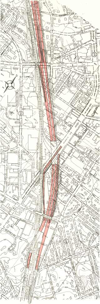
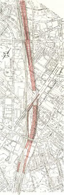
1959
1959
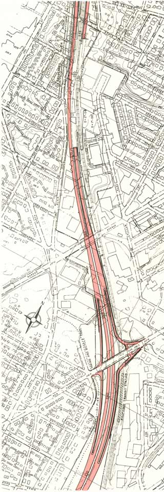
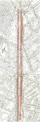
 1962
1962
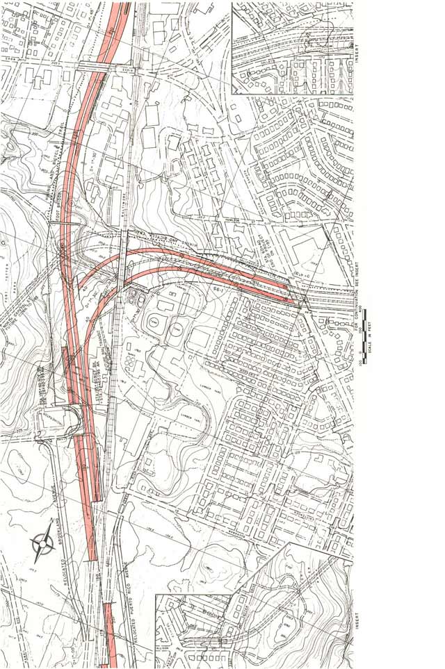
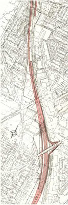
 1964
1964
The standard overly simplistic explanation:
It was a political game of highways being stopped in wealthier areas, and simply shoved unto NE, with the North Central Freeway being pushed from NW- as a
"white man's roads through black man's homes".
Reality:
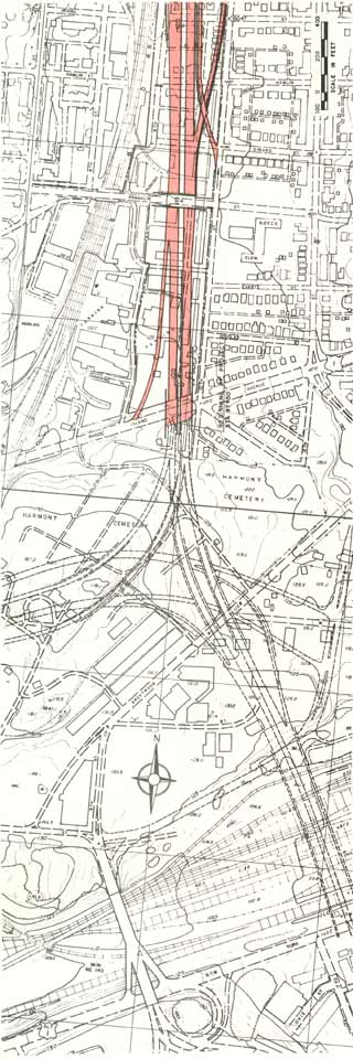
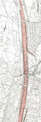
It was a trickier such game. Yes the freeway in the wealthiest area – the I-70S Northwest Freeway was canceled, while planning continued upon the other two northern radial Washington, D.C. freeways that appeared in the 1959 Mass Transportation Plan: the North Central Freeway that would become I-70S; and the I-95 Northeast Freeway. Each had been shown along all new separate routes, with the former roughly along Georgia Avenue, the latter in NE. But both would be subsequently consolidated upon a "Y" alignment upon the centrally located B&O Metropolitan Branch railroad industrial corridor, which was the only such surface route with the space for the freeway with minimum local neighborhood displacement via its lightly developed industrial strip.
That's where the freeway discussions, cir 1960-1962, had culminated, with the adaptation of this B&O “Y” Route by the JFK Administration,
Recommendations for Transportation in the National Capital Region: A Report to the President for Transmittal to Congress by the National Capital Transportation Agency November 1, 1962. A key point of this report was:
"Significance of Using B&O Route. Use of the Baltimore & Ohio Railroad corridor to bring Routes 70-S and 95 into the city is the key to meeting the need for additional highway capacity in northern Washington, Montgomery County and northwestern Prince Georges Counties and at the same time avoiding the substantial relocation of persons, loss of taxable property and disruption of neighborhoods that would result from construction of the Northeast, North Central and Northwest Freeway proposed in the 1959 plan. Further savings are realized by placing the rapid transit line to Silver Spring and Queen’s Chapel in the same railroad corridor."
The big popular outcry against the North Central Freeway did not emerge in
1962 or 1963. Rather it erupted in October 1964 with the release of the engineering report that
seriously deviated from the JFK B&O plan: a report delayed a
year plus past the 6 months it was supposed to take, past JFK’s
assassination, and up to the very next Presidential election,
representing a route planning deliberately BOTCHED as if by design to inflame local opposition. That report, ordered in 1962, started in 1963, and released days before the 1964 Presidential election, stated:
“ During the preliminary line studies it became evident that in pin pointing the general corridor of the Baltimore and Ohio Railroad in the District of Columbia should only be accomplished only after more detailed investigation of a band of alignments in that area”,
It featured 37 routes almost all over the map. It had a ‘recommended’ route -- option #11
"Railroad East- Sligo".
It largely following the railroad. But it had serious deviations in Brookland D.C., and far far worse in Takoma Park, Maryland- massively inflaming local opposition. A
Washington Post article September 30, 1964 prophetically understating titled
"Freeway Report May Touch Off Suburb Storm"
"District and Maryland highway officials have been sitting all summer on a long awaited report on the North Central Freeway that seems sure to touch off a storm in Silver Spring. The report has been proposed as the major funnel to bring traffic downtown from the Bethesda Silver Spring area.
Ordered more than two years ago, the report is still in preliminary form. It calls for a freeway connecting the District’s Inner Loop with the Capital Beltway.
In Washington, the route runs generally along the corridor of the Baltimore & Ohio railroad tracks….
The consultants, J.E. Greiner Co, of Baltimore were asked to make the study in mid 1962, it was originally expected to take six months. …
In the District the freeway will tie into with “the north edge of the Inner Loop,” Airis said. Officials from his department are still trying to determine just where the connection ought to be, he said.
One of the reasons the report took so long Airis added is that “we’ve had trouble nailing down the (Inner Loop) connection.
The preliminary report was turned over to the highway departments in June [1963 or 1964- this is not clear- though the facts ordered in 1962 and expected to take 6 months would suggest June 1963- DW]. District officials at first indicated it would be released without delay, but then kept postponing any announcements.
Concern by Maryland road officials over the suburban stretch apparently has caused most of the delay.
1963 brought major changes to the Inner Loop East Leg and approaches. However, like the 1960 I-95 Northeast Freeway, the 1964 and 1966 engineering reports truncate their respective studies to the area from the vicinity of Rhode Island Avenue northwards.
1960, 1964 and 1966


 1960
1960
 1962
1962
 1964
1964
 1966
1966
The report made public by the Maryland State Roads Commission has caused much consternation here in Takoma Park, for we are severely affected by the proposed freeway. It seems at first glance over the maps and materials available through the libraries and civic associations that the proposed 10 lane North Central Freeway takes a wide swerve away from the B&O tracks and in that fact destroys our community.
We need more than four weeks to study the plan and mobilize citizens into action; we need time to weigh the alternatives and their consequences. Therefore it is urgent that the December 15 joint public hearings in Silver Spring be postponed.- Mr and Mrs T McQuire, Takoma Park Washington Post Letter to the Editor published November 30, 1964
Notably the initial
Washington Post article dated November 12, 1964 reported that the freeway simply followed the railroad in the Takoma area, with another article, dated November 14, 1964 claiming that the freeway plans were “popular” [!]. Regarding the route deviation through Takoma Park, the reaction would be immediate, relatively broad and immensely (and quite justifiably) negative.


The Takoma Park Mayor and government passed resolutions[s] absolutely opposing the North Central Freeway as planned,
though not the freeway as per the JFK B&O concept. As the Washington Post reported on a public meeting in Takoma Park, March 10, 1965 in an article titled Takoma Park Shouts ‘No’
Most of the speakers were adamant against the roadway which was outlined in a huge map which hung behind the rostrum. Takoma Park will be split in half by the freeway declared Mayor George M Miller and the lives of elderly persons will be needlessly and extensively disrupted. City Councilman Russell B. Jones added “The Council of Takoma Park opposes the freeway definitely and unequivocally but if a decision is made that that freeway is necessary, that further consideration be given the route that is the least disruptive to the community and its older people, and that the feasibility of a railroad route be studied.
E. Brooke Lee of 8409 Piney Branch Road Silver Spring took a more moderate approach. A population 53 times that of Takoma Park would use the proposed expressway and these citizens should be given some consideration.
Relocating the expressway along the Baltimore &Ohio Railroad line could bring this added convenience to those outside the city, he suggested while preserving the integrity of Takoma Park.
At least one Takoma Park citizen though firmly supported the proposal. “What Takoma needs is a new freeway, I say a new freeway cutting right through the heart of the town to bring new life and light commerce and industry to the community" Herbert D. Smith of 11 Pine Ave declared amid boos, catcalls and jeers.
The JFK B&O route concept made immense sense, while the 1964 route deviation did not.
The deviation not only tremendously increased the local impacts - cutting a swath directly through Takoma Park’s oldest residential neighborhoods - but also added over a mile to the route.
I invite anyone to walk-drive the two different routes to see for themselves.
The 1964 deviation through Takoma Park was an all new swath cut through leafy tree residential neighborhoods constructed near the then last turn of the century, of beautiful houses- 471 which the execution of that plan would have removed.
The area around the Takoma, D.C. railroad station, though containing some like period buildings, was destined to be largely cleared and replaced by the WMATA rail transit station constructed during the 1970s, as a far more acceptable price for progress. That space directly alongside the railroad would have been largely sufficient for establishing a space for an elevated, or far better yet, a cut and cover tunneled freeway. Such a cut and cover tunnel could fit under whatever was created for the WMATA station, and to the north could be fit carefully in the space largely beneath Takoma Avenue, thus preserving the row of older homes there facing the railroad, and within the 80 feet or so behind the historic Cady Lee mansion.
Takoma Park, Maryland Mayor Miller, who was first elected to that position in 1954, unequivocally opposed the 1964 route, and was constantly re-elected to that position, even as he did not necessarily oppose the B&O Route for the North Central Freeway. He served a total of ten such terms, for a longer period of time than any other Takoma Park Mayor, before succumbing to cancer at Holy Cross Hospital in July 1972.
"By far the longest-serving Mayor was George Miller. Appointed to a
vacant Council seat in April 1953, he was elected mayor the following
April and served an astounding 19 years until his unexpected death in
July 1972. He spent his last years overseeing the construction of the
first city hall at Maple and Philadelphia Avenues, only to die before
the building was officially dedicated."
Sammie Abbott, a Takoma Park resident living at 7308 Birch Avenue, a house in the path of the 1964 option #11's southbound righthand lane, was this manufactured controversy's unquestionably most colorful figure.
He was an accomplished labor organizer in Buffalo, New York, who became a candidate for the U.S. Congress, regrettably under the Communist Party label (
his widow Ruth would exclaim and apologize to me personally that they had no idea that Stalin was the brute that they later found him out to be), and later, (1978-1985) the Mayor of Takoma Park.
Abbott had been spurred to become an anti freeway activist in the wake of the release of the October 1964 report. A highly accomplished artist, Sammie Abbott began creating numerous examples of protest art against the option #11 Railroad Sligo East North Central Freeway- examples such as the two pamphlets and the 1964 Christmas card published in the
Washington Post.

 Sammie Abbott 1964 Protest Art
Every indication I've seen or heard (including interviewing Ruth Abbott, as well as driving her around various sites of the un-built inside the Beltway and D.C. 70S (270) and 95 and the built freeway segments (she had zero fear at speeds legal throughout much of Europe, particularly when driving towards the I-95 stubs at the Capital Beltway), has the massive opposition spurred with the release of the infamous J.E. Greiner study report in October 1964. Not earlier.
If there had been any controversy about the B&O North Central Freeway when JFK was still alive or even into early-mid 1964, it was a small fraction of that that erupted in October – November 1964.
Indeed, that October 1964 dated engineering report was seen as if designed to take people by surprise and to piss them off- an idea conveyed by the September 30, 1964
Washington Post article
“Freeway Report May Touch Off Suburb Storm".
The engineering report would justify its relatively modest swerve away from the railroad into Brookland as conserving relatively scarce industrial space as opposed to housing, without mentioning that this included the historic Brooks Mansion!
Yet it would not even attempt explaining the ¼ away swerve away from the railroad through Takoma Park, Maryland.
This was never mind the far far higher impacts of a new swath removing 471 houses rather than say 30 along the railroad.
Nor the explicit November 1962 J.F. K. directive:
“Use of the Baltimore & Ohio Railroad corridor to bring Routes 70-S and 95 into the city is the key to meeting the need for additional highway capacity in northern Washington, Montgomery County and northwestern Prince Georges Counties and at the same time avoiding the substantial relocation of persons, loss of taxable property and disruption of neighborhoods that would result from construction of the Northeast, North Central and Northwest Freeway proposed in the 1959 plan.”


 1964
1964
With reducing building displacement a key point, these route deviations represented a clear betrayal of JFK's vision: a President who in early 1963 had canceled the highly unpopular I-66 North Leg West route along Florida Avenue and U Street, by calling for a look for alternatives that lead to the 1965 emergence of the I-66 K Street Tunnel proposal. Indeed, President Kennedy and his wife Jacqueline had expressed an interest in Washington D.C. planning during his inaugural ride along the Federal Triangle, and in all likelihood more involved himself with such planning issues than his predecessor Dwight D. Eisenhower, or perhaps any of his successors so far.
Indeed,
he was likely aware of that at
that time for the proposed Boston Inner Belt which featured proposed designs
for partially encased box tunnel segments beneath new pedestrian promenades. As JFK was from Boston and undoubtedly
somewhat familiar with that area along with that alongside Catholic University
of America (where the road there today is named after the 1962-1971 Speaker of the
House, John William McCormick), I can wonder if he ever envisioned a design like that for alongside
CUA.
John McCormack Drive
between B&O railroad and Catholic University of America
As a product of the local planning discussions of the early 1960s, the B&O route North Central Freeway had enjoyed the support of such organizations as the Committee of 100 on the Federal City (founded by 32nd U.S. President Franklin Delano Roosevelt's maternal uncle, Frederic Adrian Delano in 1924), which favored it as a 4 lane I-70S and I-95 each converging into an 8 lane I-95 North Central Freeway. With the November 1962 White House report placing it immediately along the railroad’s eastern side, it spurred no such popular outrage as would occur 2 years later and subsequently, with the route's botching but a part of a series of events designed to steer popular sentiment against this freeway along the B&O corridor which ran alongside Catholic University of America.
As if on key, the assassinated JFK’s successor fanned the flames of NE-NW class resentment by stating his opposition to the NW Freeway, with a January 17, 1965 Washington Post article's emphasis upon the number of lanes - 10 - conceivably masking the arguably greater intrusiveness of the route deviation away from the railroad through Takoma Park, Maryland.
And likewise, organizations, including this "Committee of 100", used the indignation against the 1964 plan as the reason -- or excuse -- to reverse their position on the B&O route concept, under the mantle of saving the homes of Blacks --
never-mind that prior to this highway planning perversion, the B&O Route was selected for its central location, and for being the route displacing the least number of homes.
As if on cue, this new opposition from attorney Peter S. Craig was accompanied by the support of the powerhouse Washington, D.C. law firm of
Covington &Burling, with a law suit alleging a lack of support from the appropriate government entities
before such had likewise reversed their support.
Such is an opposition, as indicated by the colorful protests, centered upon saving the 69 (or 34 as the plan was refined by 1970), holding out even against the route of the freeway with the highest utility with the least displacement as developed by 1973 with the B&O-PEPCO power-line route, displacing a total of 59 dwellings all the way to the interchange B near New York Avenue- a number comparable with the recent Virginia Springfield Interchange reconstruction project, and Maryland's Montgomery County Inter-county Connector- each displacing 57. With the Woodrow Wilson Bridge replacement project displacing 335 dwellings, and the feasibility of constructing a
geometrically acceptable tunnel link to the northern end of the existing I-395 Center Leg displacing as few as 33 dwellings, we ended up displacing more dwellings by NOT completing I-95 through Washington, D.C.
How the government would handle this sort of 'planning' designed to fan resentment and opposition,
in order to foment emotion and irrationality with the denial of the proposed freeway link’s basic utility- never-mind that the “Y” route replaced 3 separate freeways within a northern sector with
no radial links between 9 o’clock and 3 o’clock (and 11:00 and 2:30 regarding parkways which don’t allow trucks, at least regarding the freeway’s basic need versus the issue of the number of lanes). As the Washington Post reported April 4, 1965 in an article 'Unit Opposes Any Freeway In NE Area'
The Save Takoma Park Committee issued a statement yesterday welcoming the highway chief’s “admission that the $350,000, three year (consultants) study is inadequate.”
“But their proposal for a new rote survey evades the real issue- namely, that no study has demonstrated that this ten lane freeway is necessary.”
How the media reported certainly help mold popular opinion. An early example of this is the December 28, 1964 Washington Post ‘Potomac Watch column article The Game in Upper Northwest
REALPOLITIK IN THE DISTRICT of Columbia is a game played best in the upper northwest.
That’s’ why plans for carrying Interstate 70-S into the city have been shifted over the years from the Wisconsin Avenue corridor in Northwest Washington to the North Central Freeway route in Northeast Washington. In the Northwest, protectors of the status quo use phone calls first names and chats at the country club. On the other side of town they use picket signs, jeers and letters of protest. In both cases, the goal is to keep the expressway the expressway—any expressway – from their side of town
SO FAR THE OPPONENTS of the Wisconsin Avenue corridor have been highly. Highway planners have been forced to look for another route n the other side of Rock Creek Park.
The shift was not racial. Both routes would run through white and Negro neighborhoods alike.
But the North Central Freeway would run for a long stretch alongside the Baltimore & Ohio railroad tracks.
The Wisconsin Avenue corridor would nick the Chevy Chase Club.
The North Central would displace families of modest means.
The Wisconsin Avenue corridor would displace some members of the Establishment.
The North Central has drawn the opposition such as the Woodside Forest Citizens Association and the Save Takoma Park Committee.
The Wisconsin Avenue corridor raised the prestigious hackles of the Metropolitan Washington Board of Trade, the Federal City Council, Woodward & Lothrop and the chairman of the Riggs National Bank.
IT SHOULD BE NOTED however, that most of these groups indicated link through Northwest Washington for interstate 70-S, a proposal that subsequently bogged down mainly because of difficulties with parkland. They did not suggest putting it on the other side of Rock Creek Park.
At hearings in Silver Spring earlier this month the opponents of the North Central set up picket lines with outspoken protests such as “Fight Funk’s Folly” “In A Blue Funk”, and “Funk Will Meet His Waterloo.” Maryland Roads Commission Chairman John B. Funk’s replies were met with boos.
The foes of an expressway alongside Wisconsin Avenue had subtler lines of communication open to them.
All the chaps at the Chevy Chase Club had to do, for example, was to wait for the late District Commissioner David B. Karrick to show up for a round of golf to tell him what they thought. An old-line Washingtonian Karrick was not about to preside over the club’s dissolution – or even rearrangement of its golf course.
After two years of hot community debate, Karrick and Engineer Commissioner A.C. Welling outvoted Commissioner Robert E. McLaughlin in April of 1959 to kill the Wisconsin Avenue corridor.
“Boom Boom” Welling (he like to open new projects with cannon shots) had undoubtedly been cautioned extensively by then to hold his fire on freeway projects through Northwest Washington.
THE PROPOSAL however, was revived by the National Capital Planning Commission under former Chairman Harland Bartholomew. Then early in 1960 the Bureau of Public Roads said any interstate from Denver Colorado to Pooks Hill, Bethesda ought to come into town by the straightest route- the Wisconsin Avenue corridor. That brought out the big guns. Four committees of Congress jumped into the dispute. The upshot was a five year Congressional freeze on freeway construction through the Northwest west of 12th Street NW.
Out of all this came the proposal for the ten lane North Central Freeway announced this fall.
Both may be needed one day. Even Gen. Braddock thought that the Wisconsin Avenue corridor the best way to .. Rockville and that was in the French and Indian War. The North Central on the other hand would serve the more populous Silver Spring and Wheaton areas, among others.
Naturally no one wants a freeway to come barreling through his living room. Members of the Establishment have just as much right to object, as the families in the path of the North Central.But … [making] the North Central tens lanes wide should be looked at critically. District highway officials … [did this] .. because they say they are going to leave Northwest Washington alone.
The north Central should be able to stand on its own feet. But it seems unfair to ask residents to make room for ten lanes in order to buy time for the Northwest. Property owners there should have to face up traffic demands in their neck of the woods, to.
Note how the entire history cir 1961-1962 culminating in the JFK Administration report of Nov 1962 is compressed into a single sentence “Out of all of this came the proposal for the ten lane North Central Freeway announced this fall." No mention of the B&O Route of 1962, nor its betrayal by that strangely over-delayed report released nearly 15 months over-due, nor that if there had been controversy in 1962-63 it was a fraction of that engendered by the October 1964 released report.
This selective omission would be repeated ad nausea, by subsequent mass media reporting so designed to steer sentiment concerning what was a relatively UN-controversial proposed freeway from the JFK Administration that was deliberately botched at the time surrounding and following his assassination. This was the selective report to focus solely upon I-70S being pushed east of Rock Creek Park, with otherwise precious little reference to the topographical realities, to effectuate a spin of this as primarily a battle -- regarding I-95 -- of saving 69 or 34 houses closest to the railroad.
By April 1965 nonetheless officials declared they would do a restudy. Consistent of the idea of inflaming opposition, the new plan was ELEVATED over the RR version- never mind at least the proposal of the Committee of 100 on the Federal City cir 1962-64 for a low level version. The elevated high level version would occupy much of 1965 in the public’s attention before being dismissed, and subsequently followed by calls and promises for a new “supplementary” study.
That
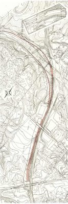
1966 plan, published in the supplementary North Central Freeway report by J.E. Greiner associates was a step in the right direction.
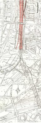
This version featured a 6 lane I-70S that would flank the railroad. That would converge with a 6 lane connection from an 8 lane I-95 via the District Fort Drive Route (which had its continuation in Maryland via Northwest Branch Park)- with the extra 2 lanes connecting to a connection to North Capital Street - arcing further westward into Fort Totten Park than the 1964 version, to join together and pass through a set of tunnels to the railroad's eastern side, and quickly neck down into a 10 lane I-95 North Central Freeway in the vicinity of Taylor Street. From there, the 10 lane 1-95 North Central Freeway paralleled the B&O railroad's eastern side, displacing only industrial properties southwards to Monroe Street, and some 69 homes further south between the railroad and 10th Street NE. Unlike the 1964 plan it entirely avoided the Turkey Thickett neighborhood and the historic Brooks Mansion. To the south of Jackson Street where the railroad begins turning southwesterly, the freeway route would maintain a southerly direction, leaving an opening between it and the railroad that becomes wider as it approaches Rhode Island Avenue.
Further south the freeway would met "Interchange B" with the Inner Loop, thus connecting with the 6 lane I-295 East Leg, and the 8 lane North Leg East continuation of I-95 to the Center Leg (3rd Street Tunnel).
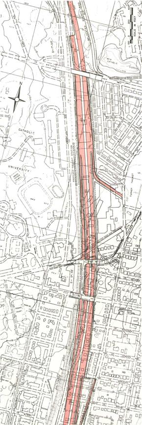
With an eye towards better land space utilization, the 1966 'supplementary' report included a suggestion of a lid atop a segment of the I-95 North Central Freeway alongside the main campus of Catholic University of America just east of the surface road along the east side of the B&O railroad, though not to the south where the design was also somewhat depressed grade.
 Cut and cover tunnels alongside Blair Park
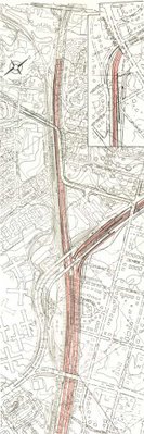
I-70S enters near D.C. through a set of cut and cover tunnels compatible with Montgomery Community College, preserving Blair Park, AND transitioning to a configuration to flank the railroad (rather then having it all to the east) to reduce the conflicts.
 3 lanes hugging each side of the B&O railroad in Takoma, D.C.
 Interchange at New Hampshire Avenue
1966 North Central Freeway at Brookland- Catholic University of America
Entirely east of the railroad further south in Brookland, it avoided Turkey Thicket and Brooks Mansion, reducing the number of dwellings for the I-95 portion of the North Central Freeway to 69 houses (1910-20s vintage).

The 1966 supplementary study included the future addition of constructing a lid atop the depressed portion alongside Brookland, potentially making a cut and cover tunnel.
 1966
1966
By late 1966 the controversy had significantly died down, with the agreement of the various government agencies upon the 'supplementary' study B&O Route,
only to be again inflamed by the brand new Federal Highway Authority.
According to a letter dated June 1, 1967 from Takoma Park resident and former --- to Maryland Governor Spiro Agnew:
Citizens of Takoma Park and Silver Spring had reason for their demonstrations of bitter dissatisfaction with the highway authorities of your predecessor's administration. After we had been given reason to believe that the causes of our protests had been in at least some part overcome, the matter now threatens to break into renewed bitterness. I am sure you will wish to avoid this as much as many of us.
We showed that the methods of traffic projections which were claimed to justify the North Central were fallacious, the results in error by as much as 400 percent. Our contention was tacitly admitted in "re-studied" versions of the proposal made public last year, sharply reducing the original plan of 5 lanes each way.
The re-studied proposal also tacitly admitted that the route first proposed was needlessly, even carelessly if not ruthlessly, destructive of our communities. The new version hugged both sides of the existing Baltimore and Ohio railway, thus avoiding a new swath of destruction to divide our communities and sharply reducing the number of homes to be taken.
The reduced, re-routed proposal was made public last year with endorsement of D.C. And Maryland highway authorities. The D.C. Portion was forced through the National Capital Planning Commission by votes of representatives of the D.C. Highway Department and of the U.S. Bureau of Public Roads. From this we concluded, reasonably enough, that the highway authorities of the two jurisdictions (Maryland and D.C.) had reached a firm understanding with the Bureau of Public Roads.
Many of us were therefore astonished and aroused to preparations for renewed protests when Washington newspapers recently reported that the Bureau has acted to open it all up again. We have not found the Bureau forthcoming with candid information, but the press articles intimate an intention to force Maryland to accept modifications of route or design ostensibly "cheaper."
The result is that the whole controversy, which had been somewhat quiescent, is beginning to agitate the communities again. I can assure you this is so, for although I recently resigned chairmanship of the Metropolitan Citizens Council for Rapid Transit and write this simply as an individual citizen who wishes your administration well, I do remain in close touch with neighborhood sentiment on transportation-related issues.
As the Washington Post would report, May 8, 1967:
Top officials of the Bureau have ordered a full review of the plans for the 3 ½ mile road … While it is good practice to disrupt as few people as possible in road building, is it worth the added cost of $22 million?
… Rejection by the Bureau would certainly fan the embers of one of the Washington area’s freeway controversies spearheaded by a group called the Save Takoma Park Committee. It rallied the residents of the middle income suburb composed largely of turn of the century homes on tree lined streets to strident opposition at hearings in Washington and Silver Spring on the original [1964] alignment.
This cheap skate attitude - $22 million upon a $271 million 1966 figure project -- surely served the purpose of poisoning popular sentiment against the B&O North Central Freeway.
 JFK Postage Envelope Issued May 29, 1967
Notably latter 1966- early 1967 was a time of transition and bureaucratic reorganization, with the U.S. Bureau of Roads being replaced by the then brand new U.S. Federal Highway Authority, with the outgoing administrator
Rex Marion Whitton, who served from 1961 to 1966,
quoted by the Kansas Evening Star about his retirement that at [the age of] 68
"I want to get out while I am still winning or at least that I am still winning"
as if on que of an impending planned scuttling.
 Rex Marion Whitton
 Lowell K Bridwell
His successor,
Lowell K Bridwell (1967-69) was later the FHWA director overseeing New York City’s to be scuttled Westway Project, which would have replaced Manhattan's elevated West Side Highway with a modern interstate highway, the southern part via a tunnel in new land fill within the pier area, beneath a new waterfront promenade, parkland and new development providing the perpetual benefit of property tax revenue, thereby creating an new source of perpetual property tax revenues; the Westway Project would have no expense to the City of New York , yet was unfairly maligned as a waste of money, as a reflection of the generalized post 1961 idea that the U.S. was too poor to afford highway and transit. Notably Bridwell died in 1986 at the age of 62 a mere year after Westway’s September 1985 cancellation.
The dynamics of a high level decision to scuttle the assassinated President's B&O Route North Central Freeway were further displayed by the words and actions of again subverting the B&O NCF by new US Department of Transportation Administrator Alan Boyd, starting with the adaptation of the historical revisionism that “forgets” to mention the route’s development 1961-1962, and its subsequent botching. As the Washington Post reported, January 15, 1968 Transportation Secretary Alan S. Boyd, who has refused to approve plans for the North Central Freeway, said yesterday the path of the road through Northeast Washington was determined
not by “where the traffic wants to go,” but by where “political opposition was insufficient to stop it.”
“All the traffic surveys say it should be built along the Wisconsin Avenue corridor,” Boyd explained in an interview on WTOP television’s Capital Conversation.
“But the people who live along Wisconsin Avenue or have business there have much more political clout than the people on the other side of town.”
Ten years ago the freeway was planned to run along the District shore of the Potomac River, Body said.
But it was pushed eastward,” he said, “until political opposition was insufficient to stop it.”
The outer approved by the National Capital Planning Commission in 1966 would run from the Capital Beltway through Silver Spring Takoma Park, and Northeast to a major interchange near Union Station. It would provide high speed access to downtown Washington from eastern Montgomery County.
“We’re going to have to find a better way to do it than to say we’re going to take the property of poor people and leave everyone else alone.” Body said. “That’s not the way the way the traffic moves.”
Boyd argued that highways could be built “to compact themselves reasonably well” in any neighborhood if stores and homes were built in the air space over the roads.
“We should not just tear up the homes of poor people and Negroes,” Boyd declared. “We ought t make a determined effort to put freeways where traffic wants to go.
Boyd, who said in November he would not approve another highway project, the Three Sisters Bridge, as presently planned, said he would continue his opposition until he knows “what’s going to happen to the traffic” that would use it. Under present plans, he said, “there’s no provision for a distribution system” to take heavy traffic from the bridge into the Northwest section of Washington
And, as reported in the Drew Pearson The Washington Merry Go Round column
'D.C. Mayor on Spot in Freeway Fight' (yes the Drew Pearson who maligned the Tucker Motor Car), on February 21, 1968:
Secretary Boyd also argues that Negro communities are not the only ones to be relocated to make room for suburban freeways. Wealthier communities should move too. Specifically he has held up the North Central Freeway in Washington because it was shifted over from a high bracket residential community to a low bracket , because the white residents pack more political punch than Negroes do. “We should not just tear up the homes of poor people and Negroes,” says Boyd. “We ought to make a determined effort to put freeways where the traffic wants to go. We’re going to have to find a better way to do it than say we’re going to take the property of poor people and let everyone else alone.”
Boyd conceivably had the option of promoting reviving the Northwest Freeway- consider how that freeway could have fit within the re-development footprint in downtown Bethesda- Boyd had practicalities that he could have advanced.
He could have pointed out that much of downtown Bethesda was to be demolished and replaced owing to the inevitable transit induced densification, anyway.
Hence he could have promoted that segment as a cut and cover tunnel beneath new buildings there as well as in Friendship Heights.
Further south, where the grade must further descend owing to the NW Washington D.C. topographically, he could have promoted a revision of the southern portion via a deep drilled tunnel straight from the Tenley Circle area to the existing end of I-66. That would have been roughly twice the length of the 1960 I-95 Northeast Freeway study option with 4 x 2 tunnels 4,000 feet in length, and would have made a powerful backup to his statements concerning social equality, and indeed the famous quote of JFK-
'ask not what your country can do for you; ask what you can do for your country'.
Rather, he conformed with the dynamics suggested by the outgoing U.S. Bureau of Roads chief's comments about getting out "while it still appeared that we were winning."
Indeed, he not only repeats the established media "spin" concerning I-70S (that 'forgets' the 1961-62 history leading to the JFK Administration's November 1, 1962, along with the route botching of the long delayed initial engineering report), thereby sustaining a resentment against the wealthier NW, he extends it to oppose I-70S along the railroad through Silver Spring and the Takoma Park area, and also to I-95 through the western edge of the Washington, D.C. neighborhood of Brookland, displacing 69 WW1 era townhouses (with a 1970 revision reducing that to 34), just across the railroad from Catholic University of America.
Indeed this geographical class angle would be useful, given that B&O and the Northeastern I-95 would have displaced but a fraction of that for the I-70S segment, due to the later construction of brick houses along the railroad's western side Blair Avenue, along with the Montgomery Gardens apartment complex near Blair Park.
The reaction of
"white mans roads through black mans homes" had been the response to the botched planning unveiled in 1964, with its review of a broad array of route options of the type of freeway planning of the 1959 Mass Transportation Plan rejected by the planning discussions that had lead to the adaptation of the I-70S / I-95 B&O North Central Freeway in 1962 by the Committee of 100 on the Federal City and the Kennedy Administration. Hence it was a betrayal of the participants who accepted this eastward shift as the means of routing I-70S with the least displacement (and as the most logical-cost effective means employing the existing areas of the rail-yards for routing traffic from I-70S and I-95 into and through the Inner Loop: certainly a deep drilled I-70S tunnel from Tenley Circle to I-66 would work, especially with an under Potomac Tunnel to Virginia Route 27 and or 110, but would not handle I-95 traffic, whereas the B&O concept handles I-70S and I-95 traffic).
The 'social justice' idea conveyed with this freeway planning politicization can be seen as a history extending back a century earlier when the B&O Metropolitan Branch was routed where it was in NE with that corridor significantly industrialized, while the comparable stream valley in NW, Archibald-Glover Park, remained more or less in its natural state.
Boyd (like any other such FHWA figure) has the option of promoting a further design evolution of the I-70S/ I-95 B&O North Central. One with greater capacity, given his testimony before the House subcommittee on roads -- reported by a December 6, 1967 Washington Post article "3 Major Road Projects Are Unwise" -- against the North Central Freeway "as it is now designed" describing it as "a tremendously expensive and inadequate artery."
He could have promoted a re-design without the neck-down and within a right of way avoiding the historic Brooks mansion to the east, and the line of Catholic University of America buildings to the west with the freeway entirely under-grounded southwards of Taylor Street. The extra capacity could have been added via cut and cover tunnel carriageway along the railroad's west side directly beneath John McCormack Drive- named for the 1961-1971 Speaker of the U.S. House of Representatives. Hence the planners could have accommodated the traffic
while maintaining and even enhancing the tranquility of this area directly alongside Catholic University of America: note Donald Trump's promoted treatment of the 57th to 72nd Street segment of Manhattan's West Side Highway of new concrete box tunnels directly beneath the new Riverside Park Drive.
 Manhattan's Riverside Drive Tunnel
 Boston I-93 Central Artery Tunnel/Promenade
Consistent with this expansive view of 'social justice' meaning for the broadest segment of society, he could have gone further with the idea of extending the legacy of monumental Washington, D.C. by combining the tradition of the Mall as well as such places as Meridian Hill Park, make the surface area atop the new underground I-95 North Central Freeway Tunnel, with its underground walls designed to accommodate a lowering and tunnelization of the two track heavy railroad, and optionally portions of the two track WMATA aluminum rail car transit Red Line. Such an under-grounding would permit re-establishing vast portions of this corridor as parkland, and conceivably be advanced to bring the long buried creak back to the surface. One would think that given all the talk about improving cities, that there would be advancement of such things as a cut and cover and deep drilled NW Freeway, and especially a largely tunneled cut and cover North Central Freeway beneath a new linear park extending atop the railroad corridor sculpted into the land and its architecture into the shape outlined by God and Man as situation and framed by Washington, D.C.'s majestic Union Station: a shape that may be called the
"Grand Arc".
 USNC Extending the Legacy with UN-official addition of the Grand Arc 95 /270E
 1997+ I-270 Takoma Station Town Square/Tunnel
Abbott and his allies never had the opportunity to see a serious such under-grounded North Central Freeway, and had taken their hardline stance spurred by the unveiling of the deviant 1964 "option #11 Railroad East Sligo extended even to the 1962 B&O route, according to Zachary M. Schrag’s The Great Society Subway: A History of the Washington Metro,at p 121, because this would still displace “a line of houses parallel to the railroad”, even though a fraction of those by the 1964 plan.
Schrag does not elaborate, but of these, the best were and remain those along Takoma Avenue on the RR’s east side, at Takoma Park Maryland’s northwestern edge, plus the northernmost house within Washington DC to the RR’s east side, the landmark Cady Lee Mansion with a mere 85 feet setback- all situated with adequate room to construct a cut and cover tunnel extending beneath Takoma Avenue to join the already (1966) planned cut and cover tunnel along Montgomery Community College. Extending the cut and cover configuration beneath Takoma Avenue, whether with 2 in each direction all along the railroad's east, or 3 in each direction flanking the railroad would fit, and have sufficient length to drop with the topography to extend the tunnel further south within the footprint of what was cleared for the WMATA station and suitable for new transit induced development.
The 1971 DeLeuw, Cather Associates and Harry Weese & Associates, Ltd. Washington D.C. version had the WMATA station area with a cut and cover I-70S North Central Freeway Tunnel with all six lanes to the railroad's east, thus displacing the historic Cady Lee Mansion along with the Takoma Avenue houses- and thereby creating a new means of inciting opposition. Before anyone advanced alternative designs more incorporating the space along the railroad's western side, as it enters Washington, D.C., perhaps with a set of 4 lane tunnel flanking the railroad -- I like the idea of employing this segment as a bypass for Maryland 410 around rather than through Takoma Park -- Maryland drops this link altogether in 1972.


Takoma Park area plates for the 1966 supplementary study B&O Low Level Route North Central Freeway, and the 1971 version


Sam Abbott’s artwork – of which there is much evident talent -- might suggest a plausible subconscious reason for his sentiment, assuming that he necessarily liked the landscapes he chose to paint. Much of that art was of rail-side industrial mud flats as those in his native Buffalo New York where he worked, organized, and was arrested and imprisoned; it was there, in the lock up with his best friend, where they here visited by that friend's daughter, Ruth, who was Sam's future wife.
Certainly, according to Ruth, he was partially spurred against the freeway by her father and his friend who inveighed against the petroleum economy at a time when freeway construction was occurring roughly at the time that many electric rail transit lines were being deactivated, and replaced with smelly and noisy diesel buses (even as heavy rail had already been using diesel electrics).
Sam Abbott passed away in 1990.
Thomas Airis passed away in July 1991.

 Abbott, Airis 1970 D.C. City Council hearing
US National Capital Planning Commission
reversed itself in December 1968- the botching and the spin having done its job prior to the politically turbulent events of that year that brought the MLK and RFK assassinations respectively that April and June.
It was simply a
'white mans road through black mans homes', as the newspapers defined it: a simple truth in the context of the botched 1964 planning,
but given the physical reality, an over simplification obscuring the more complex matters of political influence and power.
Not building the North Central Freeway saved, as per the 1966 design, 372 dwellings within Washington, D.C. and 163 within Maryland, with 69 of these, plus 110 respectively for the I-95 Northeastern Freeway, or 59 total for the 1973 I-95 B&O/PEPCO Route proposal.
This compares with the figures of 720 and 531 for the 1964 plan, 1,095 in D.C. for the 1960 I-95 Northeast Freeway near the B&O railroad; and 74 and about 1,000 respectively for the Wisconsin Avenue corridor and the east of Rock Creek Park segment of the Cross Park Freeway serving as the southernmost I-70S segment to its interchange with the I-66 North Leg of the Inner Loop Freeway at 14th and U Streets NW.
Of all of these, the most cost effective route -- B&O-PEPCO -- is endangered with ill advised real estate development along the north side of New Hampshire Avenue just inside Maryland (which would be fine if planned with having I-95 pass beneath) and
just inside D.C. in the traditional open field of the Masonic Eastern Star Home, and in the Brookland - Catholic University of America area in the traditional lightly developed industrial bands to the east between Taylor Street and Michigan Avenue, and west to the south along 8th Street NE connecting with our John McCormack Drive southbound I-95 Tunnel.
Likewise, and further what should be criminally negligent for creating a hazard,
the deathtrap residential development in the I-70S Takoma Station area of wood framed dwellings within and generally at a lower grade of a potential derailment of the immediately adjacent heavy railroad that carries heavy freight cars. Meanwhile, people in Takoma Park found out that the planning of 'DE-mapping' the freeways for the sake of some extra funds to speed the WMATA system's construction (while denying a potential perpetual revenue from highway tolls- an option apparently unconsidered), provided zero promise of WMATA not one day covering some of the local green space of the WMATA facilities with new development, with a new proposal for 95 such dwellings at the Takoma Station green area and parking lots.
Meanwhile, slapping I-95 signs on the eastern portion of the I-495 Capital Beltway led to a greater traffic burden there, leading to the recent Woodrow Wilson Bridge replacement project, replacing a single 6 lane span with a pair doubling capacity, with a displacement of 335 dwellings in Alexandria, and 57 at the concurrent Springfield Interchange replacement project. A new project the 11th Street Bridge[s] finally completes a no traffic light through route that
dips down through SE, though yet nothing yet to humanely tunnel portions of the I-295 or DC 295 Anacostia Freeway, with now decades of in-activism -- consider ECTC's Marion Barry as just a start.

According to the November 26, 2000 Washington Post magazine article
"End of the Roads" by Bob and Jane Freundel Levey, Takoma Parks Sammie Abbot guilted out Peter S Craig, with Abbott charging Craig with only caring for his neighborhood- never mind the significantly lower impacts of reusing an existing railroad industrial corridor rather than a swath through parkland or residences.
"I couldn't be parochial. I had to oppose the whole thing", he says, after Sammie Abbott called him out of the blue one night and said "All you care about is the rich White folks west of the [Rock Creek] Park". "He said I was being pretty provincial", Craig says. "He guilt triped me and as a good Quaker, I fell for it."
Never mind this shift to poorer Blacker areas was exactly what was being accomplished by the enemies of the northern radial freeways as the Northwest, North Central and North East. Had not Craig or Abbott, Abbott's ECTC confederate Reginald H. Booker, Marion Barry or anyone else following this line of reasoning pondered it in SE alongside the I-295/DC 295 Anacostia Freeway? Or in Springfield interchange or the Wilson Bridge replacement projects -- even if the areas are not majority Black -- both involving displacing more residences by widening the section of the I-495 Capital Beltway that became "I-95" upon the cancellation of the less necessarily imp-active idea of completing I-95 through Washington D.C. via the least displacement route of the B&O-PEPCO combination, reportedly over protests over the 34 WW1 era townhouses while running alongside Catholic University of America.
By going with the spin established by the very establishment running the show, Sam Abbott and ECTC's doctrinaire stance against the B&O Route North Central Freeway simply went along with what the established actually wanted, an establishment most plausibly --
consider the dynamics of a political wobble effect -- with
the entity marked by the very landmark properties along the proposed freeway routes.
It could be said that, for a man as Sammie Abbott the political activist and artist described as politically angry, that he, even if unwittingly, was preserving the canvass for the ultimate expression of the shape revealed, with the B&O Metropolitan Branch railroad's head piece of Union Station, with the rail corridors covered-
Grand Arc.
If Madrid, the Capital of Spain, can do it with its
M-30 Rio Project, so can Washington D.C. with
Grand Arc 95/270.
This Washington, D.C. Status Quo of a city locally split by surface rail-yards, the traffic burden shifted disproportionately onto SE, and the general inefficiencies of the absence of the Washington, D.C. northern radials, is a continuing social and political injustice.
Douglas A. Willinger
A Trip Within The Beltway
January 19, 2012