Thursday, July 24, 2008

Media Talking Head Bob Novak Hits Pedestrian With His Black Corvette

Apparantly Bob Novak is a man who drives to make time, to say the least.

Particularly when driving within Washington, D.C.

In a Black Corvette.

So, can anyone point to what this man has ever said publically on any of his talk shows about the government's 'inability' to construct a continuous freeway system?

With all of the talk about the changed reality after 911, what has Novak or any of the other Washington, D.C. media talking heads said about evacuation routes?

Surely he's aware of how I-395 just dumps out onto New York Avenue, etc.

http://www.huffingtonpost.com/2008/07/23/robert-novak-taken-into-p_n_114510.html

Wednesday, July 23, 2008

Takoma D.C. Tranport Chock Developer Chocked SW Freeway

An Epidemic of Corridor Chocks
right within the Nation's Capital City
Washington, D.C.


The developer that is pushing the development project at the Takoma WMATA Station is the same developer that irresponsibly chocked the SW Freeway corridor with the row of 28 townhouses at the northern edge of the Capital Square townhouse project, Eakin Youngentob.

As I wrote in my original "Highways And Communities" web site:

Eakin-Youngentob "Capital Square" townhouses, on land plot between 6th, 7th, G Street SW and the SW Freeway, with row of 28 townhouses a mere 16 1/2 feet from SW Freeway retaining wall, one block south of the U.S. Department of Housing and Urban Development. This 16 1/5 foot setback is significently less then that of all of the other buildings along the southern side of the SW Freeway, which have 70-90 fete of setback.

This makes it more difficult and expensive to construct new retaining wall for tunnel roof (as the existing walls would not be likely to be so designed), hence keeping the existing SW Freeway in a configuration that divides DC SW - hence contrary to long term NCPC planning for the removal of the mass of elevated highways and railways that now cross over South Capital Street.

This also makes it more difficult and expensive to improve safety and decrease conjestion and pollution with mitigating the SW Freeway bottleneck southwards and westerly of the Center Leg -- hence more likely remaining a traffic bottleneck with ripple effects well into Virginia.

http://web.archive.org/web/20060207152135/www.highwaysandcommunities.com/Planning_Errors_D.C._Real_Estate_Development_built_ALERT.htm

WMATA's awarding this developer underscores a blatant disregard for long term transportation corridor planning.

If numbers of dwelling were the overriding favor why was the Capital Square project built as townhouses rather than something more substantial with greater numbers of such along with the setback from the SW Freeway.


Thursday, July 17, 2008

A New I-395 Gateway- If It's Coordinated With New Development

A big "if" ...

New 14th Street Bridges
with tunneled vehicular connections to 14th Street and I-395


New I-395 tunnel segment to come with replacement of the existing 14th Street Bridges. Employs virtually the same alignment that I have proposed, though with a somewhat sharper curved transition to the existing SW Freeway then necessary.

Idea of revised ramp connections to 9th Street appears to require demolition of existing building at L'Enfant Plaza, which is consistent with desire to remove the "brutalist" 1960s-70s era architecture, and which would likely be eased by removal of the row of 28 townhouses that were irresponsibly placed only 16 1/2 feet from the existing SW Freeway retaining wall in 1999-2000 as the northern edge of the "Capital Square" residential project by EYI Associates between 0th and 7th Streets. With this occurring within sight of the headquarters of the U.S. Department of Housing and Urban Development and the U.S. Department of Transportation, why did not these agencies object?

Beyond the sharper curved transition to the existing SW Freeway alignment, this NCPC plan differs from my conceptualization by lacking a split to a supplemental I-395 tunnel beneath G Street SW to ease constructibility (e.g. routing traffic- particularly during constructing the new connection to the existing SE Freeway alignment at 7th Street SW), while permanently providing additional capacity with a gentler curved connection to the north-south Center Leg (3rd Street Tunnel): easing a traffic bottleneck that customarily extends into Virginia.

The surface treatment differs with its lack of an extension of G Street SW towards the Jefferson Memorial providing some additional landfill to more integrate the area, and of a traffic circle at the 14th Street location of the I-395 tunnel portal. As I envision it, this new bridge/tunnel segment would be located on the extended axis of Louisiana Avenue.

This proposal also includes a new more literal "14th Street" Bridge -- together with the above mentioned new I-395 bridge -- crossing the Potomac River, with both having tunneled segment respectively to 14h Street and the SW Freeway. It also includes burying the railroad, preserving the existing railroad corridor but at a lower elevation accommodating a newly restored Maryland Avenue.


New development proposal by Hoffman-Struever Waterfront LLC

http://www.swdcwaterfront.com/

Yet will the authorities be able to control themselves to preserve the necessary easement for the new segment of tunneled I-395?

Or shall they place buildings directly in the path?

Boondoggles as "Capital Square", the "Golden Rule" apartment house, and a bit of the rush of development along the South Capitol Street corridor suggest the latter.

Final Approval for DC financing of Waterfront passed- SWDC Blog

A busy day for NCPC- Greater Greater Washington

National Capital Framework Plan- Continuing The Legacy


Sunday, July 06, 2008

Parochialist Planning Sells Out Valuably Useful D.C. North Central Transport Corridor

- Chocks Washington, D.C.'s sole norther north-south transport corridor;
- Sells out public need for a bit more real estate development;
- A
ltogether disregards post 911 security/evacuation route in a general planning that has disregarded civil defense
- Promoted by the government and Catholic University of America

http://www.metbranchtrail.com/Documents/5DraftChapter5.pdf
(warning PDF!)

http://wwwtripwithinthebeltway.blogspot.com/2008/05/cuabrookland-transport-corridor-chock.html

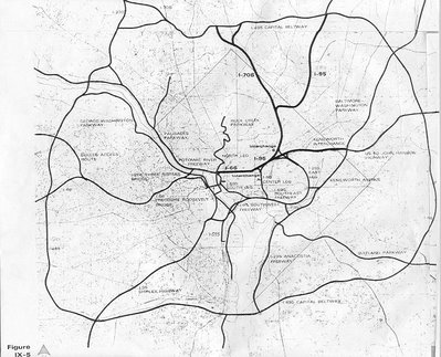
Note the placement of the North Central corridor about midway between the eastern portion of the Capital Beltway and the Potomac River. Is shown here with the I-95 Northeastern Freeway via the Northwest Branch Park route.