
for Alexandria, Virginia
Instead of pushing highways away, how about instead designing them to better harmonize into their surroundings?Since one of the main consequences of canceling I-95 through Washington, D.C. was the reconstruction and expansion of the Capital Beltway/Woodrow Wilson Bridge, I felt that this presented the opportunity to advance environmental highway design for the approach at the southern edge of Old Town Alexandria, Virginia, particularly with the Route 1 interchange.
During the 1990s, people in
Provide less additional capacity: build a replacement span with 10 lanes; this would provide a single 5 lane roadway in each direction to allow adding one additional lane per direction on the Capital Beltway, plus an additional lane per direction strictly between the interchanges at each end of the span, in
Make the river crossing a tunnel: build a tunnel to replace the 1961 vintage 6 lane span, to have the Capital Beltway cross beneath the
Push it away: re-route the Capitol Beltway with its new bridge about 700 feet to the south to increase its distance from the existing dwellings but to increase its environmental impact along the south side of Cameron Run. It would have placed the Capitol Beltway over Route 1.
I rejected these three alternatives due to a lack of capacity and flexibility for the project’s 75 year life expectancy and for the gross environmental impacts of the “pus it away” options. I liked the tunnel concept and some of the officially considered options but for the reduction in capacity and flexibility. I feel that the 1999 tunnel alternative would work if, for starters, it had some additional capacity and if it covered its approach through
By the time that I began attending meetings at the Woodrow Wilson Bridge Study and
But I felt that it did not go far enough in either direction. Extend it further east up onto the area of the bridge’s abutment would provide noise suppression where its most needed given the greater use of the accelerator to maintain speed on a climb. Also this would create an interesting viewing platform to
Extend it further west past the Hunting Terrace dwellings provides the opportunity for an actual terrace to and along Cameron Run towards the interchange with Route 1.
And what about this Route 1 interchange?
Because I thought of the official design for the new Route 1 interchange to be a monstrosity, I thought “what about something more appropriate?” Something lower. No giant overhead ramps near or over Route 1. Something quite different from conventional freeway design. Something primarily buried for the interchange ramps and the highway mainline, providing superior traffic operation ability and noise suppression, yielding the surface to new monumental parkland via a monumental new traffic circle.
In late 1996 or in 1997 I made a sketch of the area with an urban deck extended, though not incorporated with the Route 1interchange, which this sketch incorporated the official design for this interchange.

I followed that by March with an overlay over an 8 ½ by 11” overhead view of the existing interchange. From this, I made multiple photocopies which I pasted to card, cut and glued together into a primitive model, which I began showing people at various project related events, such as a rally held in front of the Alexandria City Hall, where I met various people. One of these people would be an employee from within the
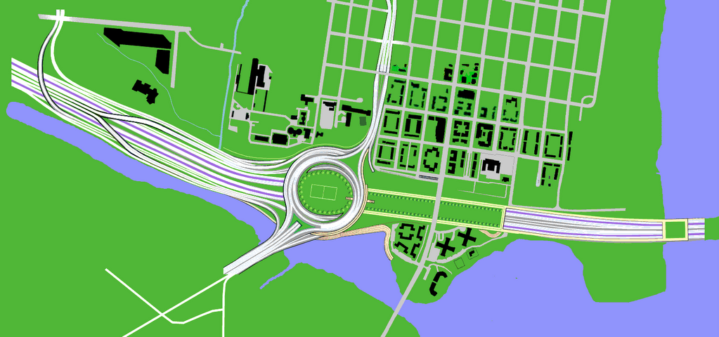 Illustration: un-official rendering of Alexandria Orb,
 Millennial Gateway for

Illustration:
for 12 lane bridge with Purple Line
with extended urban deck to terrace to Hunting Creek
By May 1998 I began the basic AUTOCAD drawing, refining it through the summer and into the autumn. In late November 1998 I first brought print outs of the drawing to one of the official meetings of the
On December 22, 1998 I filed copies with the U.S. Office of Copyrights. This turned out to be exactly one year prior to the Wilson Bridge Project's Draft Environmental Impact Statement (DEIS) of December 22/23, 1999.
I mailed this drawing to the above employee from the
Back then, I figured that adopting the Alexandria Orb design concept would add at least $100 million to the $2.2 billion Woodrow Wilson Bridge Project, which budgeted $600 million for the Route 1 interchange, and that this would be variable by staging some portions of the deck, for instance adding the deck area within the circle later. This was of course figuring that we would not have to wait until virtually completing the earlier design first to see how much it would be despised before then tearing it down (wasting $600++ million) to then adopt the Alexandria Orb.
 Alexandria Orb looking from the northwest


No comments:
Post a Comment