Wednesday, June 29, 2016
Scrap "Capitol Crossing" & Build A Park
This blog has editorialized against the Capitol Crossing air rights project atop the un-covered trenched segment of Washington, D.C.'s Center Leg Freeway as an ill advised endeavor that constricts the freeways's existing below ground level capacity by over 50% including its utterly irresponsible constriction of the emergency shoulders- all to increase the developer's profits, so done with no apparent consideration of the costs of replicating the lost capacity, via a perjurious US FHWA of 'no significant impact'.
There is an additional reason to oppose Capital Crossing. Why more more buildings? The area of Washington, D.C. has relatively little park space in the area north of the National Mall. The Center Leg has an existing park atop it for a meagerly single block.
Instead of simply scrapping the existing Capital Crossing project design, why not scrap it radically- eliminating not only the infringing support columns, but as well the monolithic new buildings of which that area has a new abundance of, and build a new park atop?
Does Washington, D.C. really need these new buildings?
Especially when the surrounding area is being heavily re-developed!
Have Congress enact legislation to purchase the air rights, scrap the Capitol Cross project, demolish the offending intrusions upon the sunken I-395 right of way, and construct a lid respecting such with a new park atop, perhaps with a hot house for plants, thus providing an oasis for such year round..
Tuesday, February 23, 2016
Capitol Crossing Air Rights - Adopts Different Design For I-395 SB On Ramp
Previously the design was for a ramp with a center loader portal in 3rd Street NW; now that has been replaced with a center loader portal in Massachusetts Avenue NW.
Reported by Greater, Greater Washington:
http://greatergreaterwashington.org/post/28316/a-new-ramp-is-coming-to-i-395-itll-be-a-little-better-for-pedestrians-and-a-little-worse-for-buses/
Both designs - Alternatives 1 and 3 - were options in the project's study report.
Both are good designs insofar that they are of the center loader configuration- a basic configuration to which urban freeway access ramps ought to be so constructed, as this eliminates the traffic conflict along the side of the local road by instead placing the freeway bound - or off ramp - traffic in the middle of the local road.
These two options were accompanied by a 3rd option - Alternative 2 - that was not of the center loader design, taking the left-hand curb of southbound 3rd Street NW.
In this blog I reported upon the selection of the design option - Alternative 1- with the center loader configuration upon 3rd Street NW.
The now selected design option - Alternative 3 - is for a center loader configuration, not on 3rd Street NW but instead Massachusetts Avenue NW.
The design now selected would require re-configuring the planned underground parking that would partially infringe upon 8 lane interstate right of way. Theoretically this could be addressed by reducing the number of underground parking spaces, and/or by an additional lower level, or a greater horizontal surface, with the lack of mention of the latter and the assertion that this nonetheless meaning greater space suggesting using the space that would have been used by the diagonal underground ramp with either of the options - Alternatives 1 and 2 -- for the transition from 3rd Street to I-395.
A September 24, 2015 letter by D.C. Councilmember Mary Cheh, to D.C. Deputy Mayor Brian T. Kenner opposes this now selected option - Alternative 3.
This letter points out that traffic from the west via Massachusetts Avenue or H Street, making a left turn onto 3rd Street to access southbound I-395 via the existing ramp or Alternatives 1 and 2, would have to travel further south on 3rd Street to access southbound I-395; instead of entering an on ramp to the north of G Street, such traffic would remain on 3rd Street for an additional 3 blocks where new residential development is envisioned, to the existing on ramp just past D Street.
It further states that this option would provide the developer with the most amount of underground space for the real estate project, ostensibly via re-assigning the space of the diagonal ramp transition of the other options.
It furthermore questions the planning process, asking "whether it followed the normal permitting progress, and - if it did not - why did it not?"
An answering letter from Kenner to Cheh defends the change, noting its elimination of the vehicular-pedestrian conflict with the right-hand turn from Massachusetts Avenue to southbound I-395, therefore eliminating one of the major vehicular traffic movements from the Massachusetts Avenue-3rd Street intersection (with all of the options nonetheless requiring traffic from the east to turn left on to 3rd Street to access I-395).
Perhaps the best option, apparently unconsidered officially would be to combine the two options, with center loader ramps on westbound Massachusetts Avenue and southbound 3rd Street, eliminating the former surface intersection conflict while reducing the distance such traffic from the east would remain on 3rd Street, and have the developer make do with less underground parking, or compensate by adding one extra lower level to the parking garage?
Of course this Capitol Crossing air rights real estate development project itself remains seriously flawed for impinging upon the 8 lane interstate right of way, and for eliminating the southbound I-395 off-ramp, as if the Washington, D.C. underground freeway system would never extend past the existing I-395 terminus at 4th Street and New York Avenue- contrary to previously seen public opinion differentiating such from more conventional suburban style surface freeways.
Though the Center Leg planning initiated with extensions with tremendous local impacts in displacement and traffic noise, the freeway planning had gone under a significant design evolution to meet local community concerns; that design evolution would eliminate a northern continuation along New Jersey Avenue, and replacing the proposed extensive new swath North Leg east-west freeway along Florida Avenue and U Street (1955 Inner Loop Report) with a tunnel primarily beneath K Street to the west (1965-1977) and along (1971-late 1970s) and then beneath (1996) New York Avenues to the east.
Such tunneled freeway proposals would be promoted by opponents to the earlier plans, notably Elizabeth Rowe during the 1960s for the I-66 K Street Tunnel, and the D.C. Mayor;s Office under then Mayor Marion Berry who was previously involved with the anti freeway 'Emergency Committee on the Transportation Crisis' in 1996 for the tunnel beneath New York Avenue which had popular local support favoring extending it further east.
Indeed, the northern Center Leg tunnel segment between Massachusetts Avenue and K Street was designed to accommodate the I-66 K Street Tunnel with a pair of one lane underground connectors, with a pair of three lane connections to the east. However, the K Street Tunnel would be "de-mapped" by 1977 owing to arguments that the world was going to run out of petroleum by the 1990s somehow rendering private automobiles obsolete, and that Virginia was not going to build their connecting I-66 segment- all of which proved false. And the 1996+ New York Avenue Tunnel planning would fall victim to a parachialist attitude within the government that a tunnel should not be built, with that corridors vehicular traffic all remaining on the surface so as to somehow encourage greater use of the WMATA subway system (despite a lack of such a route along New York Avenue), and to encourage the traffic to instead divert to less affluent areas to the east of the Anacostia River.
Recent - November 2015 - photographs that I personally took of the current Capitol Cross Air Rights Project may be seen here.
Monday, December 20, 2010
Capping I-395 Center Leg To Reconfigure Ramps

Project shall erect new buildings atop a cap atop the I-395 Center Leg Freeway southwards from Massachusetts Avenue NW, along with reconfiguring the freeway's access ramps.
This includes removing the southbound off-ramp (which is viewed as unneccessary since the freeway only starts just to the north at New York Avenue- owing to the wholesale freeway cancellations of the 1970s and early 1980s), replacing a Roman Catholic Church rectory, and again moving the Adas Israel Synagogue (now the Lillian and Albert Small Jewish Museum) moved to its present site about 1969 to accomdate WMATA subway related development.
Project shall reconnect G and F Streets across-atop the freeway, with G Street for pedestrians and bicylists, and F Street including vehicular traffic (with a full G Street connection impractical owing to the design of the northbound offramp).
Monday, December 13, 2010
Cap North Capitol Street
Malcom Kenton provides this photo at Greater, Greater, Washington, with this caption:"As I recently suggested, imagine this mini-highway decked over to become a tree-lined plaza framing the view of the Capitol dome"
Indeed at that earlier article, he writes:
Capping the depressed segments of North Capitol Street (the photo above is of the northern segment that crosses beneath Rhode Island Avenue NE) would convert them into cut and cover tunnels, expanding upon the efficency of the below ground cut with a roof to further the social benefits. As these are roads allowing and reconciling greater human activity within a given footprint, one could imagine environmentalist organizations favoring their construction- provided a philosophy of human growth.http://greatergreaterwashington.org/post/8321/make-north-capitol-street-a-true-gateway/
DDOT should begin by studying the cost, feasibility and impacts of decking over the dug-in portion of North Capitol between Rhode Island Avenue and T Street and creating an attractive public square — replacing a noisy eyesore with a neighborhood amenity. Should a full decking over prove prohibitively expensive, other more affordable aesthetic enhancements, such as covering the fences with native flowering vines, ought to be considered.
The planned park covering Dallas's Woodall Rodgers Freeway. Photo from the Dallas Observer
blog.
Converting highway corridors into public parks is becoming a trend amongst American cities. Boston exemplifies how greatly a city can be enhanced when an ugly highway corridor is put underground and converted into a well-designed park. Dallas also seeks to convert its Woodall Rodgers Freeway into greenspace.
Improvements to the North Capitol Street and New York Avenue intersection should also seek to address traffic bottlenecks. The ramp from southbound North Capitol onto New York Avenue, which is now used by two high-ridership Metrobus routes and several delivery trucks, is a notorious one. A redesign of this intersection that improves traffic flow, while also leaving space for a greenery or a public monument or fountain would greatly benefit this developing part of
the city.
Instead of a noisy, unattractive mini-freeway that benefits those driving through Bloomingdale, Eckington, Truxton Circle, NoMa at the expense of those who live along it, future residents and business owners and patrons could benefit from visual enhancements that complement the surrounding Victorian architecture and the view of the Capitol, while still allow traffic to flow smoothly. Turning this part of the North Capitol Street corridor into a desirable destination would generate benefits that could exceed the significant costs of remaking parts of the infrastructure.
Around 2005 District authorities conducted a study of the Truxton Circle area of North Capitol Street between the two depressed segments of North Capitol Street- that included an option for a cut and cover segment in this area effectively connecting the two existing depressed segments. IIRC, it did not surface or provide intermediate connections to the surface at Florida Avenue, with sparce consideration of such.
Nor, AFAIK has there been consideration of any other concepts for extending the depressed segment[s], let alone that for extending the 'cap'.
The two depressed segments appear to be a part of an upgraded North Capitol Street, that was planned to connect with the planned North Central and Northeast Freeways, as seen here (image), and here (image).
Monday, February 01, 2010
Cap Connecticut Avenue NW

An excellent idea that also should be applied to the open depressed segments of North Capitol Street at Rhode Island and New York AvenuesFound at Greater, Greater, Washington:
http://greatergreaterwashington.org/post.cgi?id=4764From Left For LeDroit:
http://leftforledroit.com/2010/01/putting-a-lid-on-it/-----
January 31, 2010Putting A Lid On It
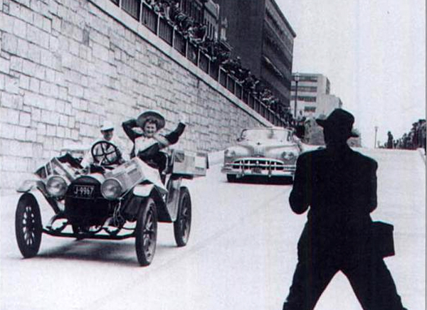
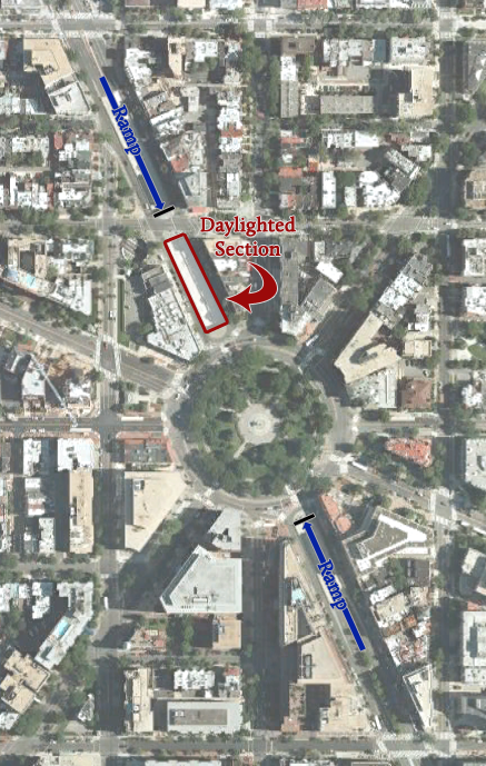
In 1950 the District opened a vehicular underpass allowing Connecticut Avenue to dive under Dupont Circle. The underpass, which still exists today, is flanked by two abandoned (and hidden) streetcar tunnels that sit behind each rusticated retaining wall. In March 2007, DDOT finished refurbishing the automobile underpass, but the city missed an excellent opportunity to restore the gashed avenue above.
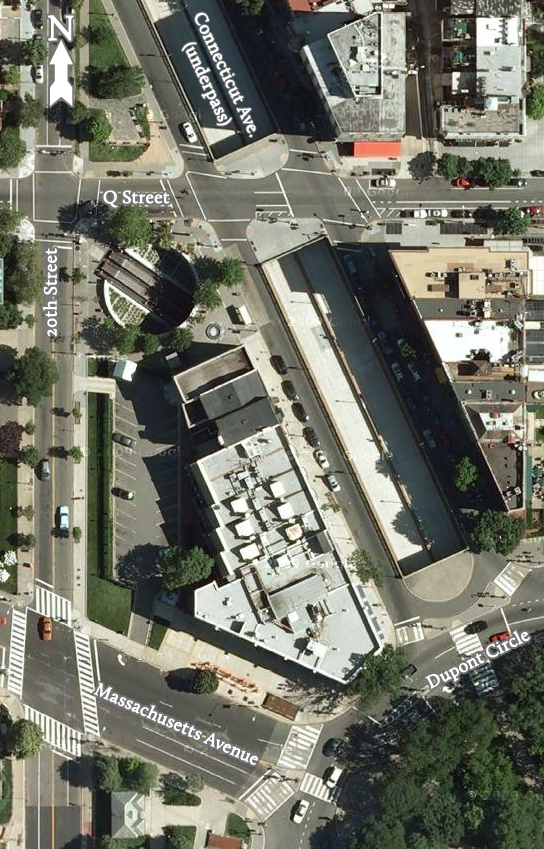
Between Dupont Circle and Q Street, the underpass is “daylighted”— exposed to the sky— needlessly monopolizing space from the block’s active street scene.
Our solution for street reclamation is simple: cap the underpass for that one block.
Connecticut Avenue, for that one block, would become much like P Street or Nineteenth Street (on the north side) as they approach the circle. Each provides a travel lane and a parking lane in each direction— far different from the cramped and highway-like atmosphere on Connecticut Avenue.
The businesses along the block would benefit from sidewalks that will double in width as well as from easier access from the roadway, parking spaces and sidewalk on the opposite side of the avenue. The increased sidewalk space will relieve the pedestrian congestion on the sidewalks (particularly on the east side) and provide space for outdoor seating and for stores’ promotional placards. Pairs of facing street benches perpendicular to the avenue will provide more seating for shop patrons and passersby.
Furthermore, the ample, seamless space would provide another truck-accessible venue for weekend farmers’ markets or art sales and other events that a stodgy National Park Service may not permit in the circle itself.
Plans are already in motion to build over I-395 and the National Capital Planning Commission dreams of covering the E Street Expressway in Foggy Bottom east of the Kennedy Center. Compared to those proposals, this one is simpler, easier, and cheaper and would benefit more residents.
Update: We considered the idea of a medial park, but worried that it would suffer from desolation due to its separation from the active sidewalks. Though certainly better than the status quo, we suspect fewer people would want to sit in what is essentially a grassy street median. That said, it would certainly be cheaper to build— and money is no small matter in this case!
The advantage of our proposal above is that it enhances existing spaces (the sidewalks) whose heavy use warrants improvement.
Categories: Recreation, Transportation
Tags: Connecticut Avenue, Dupont Circle, E Street Expressway, I-395, ideas
Monday, November 24, 2008
Eastern SE Freeway Bastardization

Evidently the topography favors covering over the existing freeway, with the new boulevard atop; not shown is the idea of covering the RR nor extending the cover towards the Anacostia River with a terrace/staircase, as already done at the Lincoln Memorial. As this involves covering the existing freeway -- IOW no new depressing -- this is a comparatively cheap freeway under-grounding, unlike say this freeway to the west between the 11th Street and 1th Street Bridges.
The idea of covering the segment of this freeway between 14th and 15th Streets SE appeared in this late 1960s illustration seen here.
Continuing this cover westerly requires removing the elevated approaches to the 11th Street Bridges, something that I propose with a replacement with below grade approaches that would conflict with the existing heavy RR, though compatible if converted to vehicular traffic or lighter rail which can tolerate grade changes upwards of 5% whereas heavy RR can only tolerate a 1% grade. As with the highway, this railroad right of way is coverable.
Continuing this cover easterly to Barney Circle would be feasible with allowances for the ramps.
Likewise, the topography allows such a relatively easy under-grounding for this freeway's needed extension to RFK Stadium- East Capitol Street, and is fully compatible with planning for a slow speed waterfront boulevard atop, including the idea of a traffic circle at Massachusetts Avenue SE. Here to the railroad should also be covered.

Only those promoting a mindless ideology against urban freeways -- alas those traditionally in control of the governments -- would rather place all of this vehicular traffic upon the surface waterfront boulevard.