B&
|
|
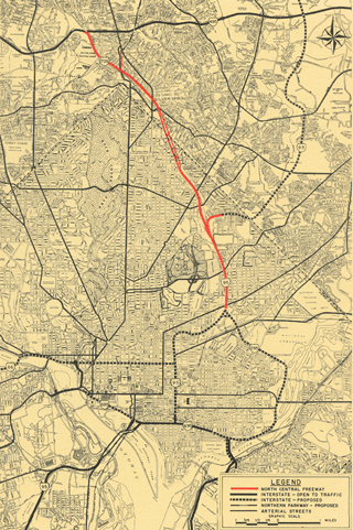
1966 B&O Route Low Level North Central Freeway
Description:
The 1966 B&O route I-70S North Central Freeway was to have started at the I-495 Capital Beltway in site of today's Mormon Temple with a set of 1 lane ramps connecting with I-495 to and from the west only, located immediately north/west of the existing railroad bridge that crosses I-495 between the Linden Lane and Seminary Avenue bridges. Approximately 800 feet south of I-495, these ramps would have converged upon a common alignment immediately adjacent to the west side of the B&O railroad with 2 lanes per direction in a bifurcated arrangement with the highway at a lower elevation than the railroad, where the southbound lanes would have entered a 500 foot long covered/cut and cover tunnel segment through the loading dock areas of Walter Reed Army Medical Center, just to the north of the Linden Lane bridge which crosses this railroad/proposed highway corridor.
This portion of the 1966 B&O Route Freeway would have continued southerly, directly along the B&O railroad's western side for approximately another 1900 feet before entering a second tunnel segment, roughly 900 feet long, to carry both directions of highway beneath the railroad to its eastern side, with this tunnel's southern portal approximately 700 feet south of Brookville Road. It would continue in a southerly direction immediately alongside the railroad's eastern side for approximately 1000 feet as an open depressed highway, and then another 750 feet that would have had a proposed Lyttonsville Road connection built directly atop its northbound lanes (directly east of a proposed Transit center for Metro Rail), and then another 1100 feet to 16th Street. There, the freeway was to merge with a freeway connection depressed and routed along 16th Street, between the east side of its existing southbound lanes and its relocated northbound lanes. This spur was to continue via the 16th Street corridor to cross beneath Georgia Avenue immediately to the south of Luzerne Drive, to feed into the proposed Northern Parkway, which would have run via Sligo Creek Park beneath the I-495 Capital Beltway and northwards towards Olney.
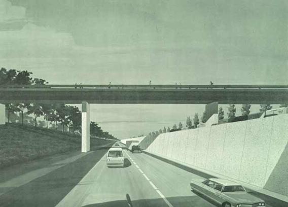 "Highway Structure Over Depressed Freeway" : Vertically Bifurcated: 4 lane segment, Silver Spring, Md.
South of the merge with the 16th Street spur to the Northern Parkway, this 4 lane I-70S North Central Freeway picked up 1 additional lane in each direction, and continue with 3 lanes in each direction along the B&O railroad's east side, crossing beneath an overpass for Spring Street, before crossing over Colesville Road (and continuing through the site of today's Silver Spring Metro bus depot), before entering a 460 foot long tunnel to cross beneath Georgia Avenue, with the alignment shifting just far enough away from the B&O to clear the northern approach to the Georgia Avenue underpass (dedicated in 1948). Roughly 1300 feet further along, the southbound lanes were to have entered a roughly 500 foot long tunnel to cross under the B&O railroad to again run along its western side to transition to a brief (roughly 350 foot long) depressed segment, before entering a 700 plus foot long tunnel beneath the Blair Park tennis courts, with its southern portal about 100 north of the Juniper Street bridge (now defunct).
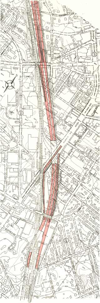
 "Depressed Freeway Showing Wall Design and Tunnel Portal" : 6 lane segment, Silver Spring, Md.
Meanwhile, the northbound lanes were to run in a parallel 700 plus foot long tunnel located immediately east of the B&O railroad, just west of Montgomery Community College, between Chicago Avenue and the Juniper Street Bridge. With its 3 southbound and 3 northbound lanes respectively flanking each side of the B&O railroad, the 1966 B&O Route North Central Freeway would have continued briefly past these tunnels at a grade lower than the railroad before rising above the railroad in the vicinity of Takoma and Buffalo Avenues, just before entering Washington, D.C. Within the District, it would have overpassed Piney Branch Avenue, Cedar, Aspen, Whittier, and Van Burean Streets, as essentially a wider version of the existing railroad berm. Immediately south of Van Burean Street, the northbound lanes would have descended into a 1300 plus foot long tunnel to bring the northbound lanes to railroad's west side, where both directions would have continued south, passing over Kansas Avenue and beneath New Hampshire Avenue. Approximately 600 feet north of Riggs Road, the 1966 B&O Route North Central Freeway would have begin to swing away (westerly) from the railroad, crossing beneath Riggs Road roughly 300 feet west of the railroad, and then beneath a new footbridge roughly 600 feet west of the railroad, before turning back towards the railroad at Fort Totten: the location of the I-70S North Central Freeway's merge with the I-95 Northeast Freeway.

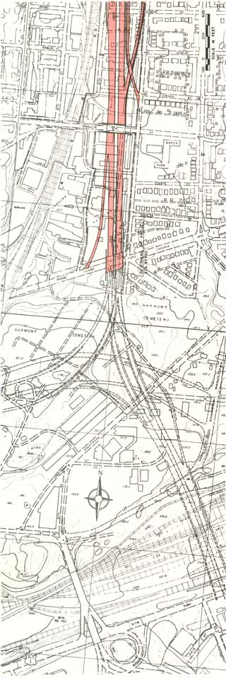
As per the 1964 plan (Route #11 "Railroad East-Sligo), this 1966 plan had the Washington, D.C. Portion of the I-95 Northeast Freeway alignment via the Fort Drive Route, located between Galloway and Gallatin Streets NE, entering the District from a Maryland routing via Northwest Branch Park in western Prince Georges County. Both the Maryland and District portions of the I-95 Northeast Freeway were to have 4 lanes in each direction, and have entered the District in a depressed below grade configuration crossing beneath South Dakota Avenue, with the proposed Metro Rail Green line located in its median. Immediately west of South Dakota Avenue, these plans had I-95 transitioning from 8 to 6 lanes, with 1 lane in each direction extending to and from a North Capital Street Future Connection to I-95, built via bored tunnels beneath Fort Totten Park. The 6 lanes of I-95 were to have turned southerly to join the North Central Freeway alignment, with the southbound I-95 lanes in a approximately 600 foot long tunnel, emerging to immediately parallel the I-70S lanes, crossing beneath a 300 foot long deck next to the incinerator, and merging together approximately 1500 feet to the south, 400 feet before entering a 1000 foot long tunnel bringing the southbound lanes to the railroad's east side. A separate 1000 foot long tunnel, with its northern portal approximately 100 feet north of the southbound I-70S/I-95 merge), transitioning the northbound lanes from the railroad's west side at Fort Totten, to its east side southwards between the railroad and a relocated Puerto Rico Avenue, and crossing with the railroad beneath Taylor Street, towards the west Brookland/Catholic University of America area. With 6 lanes of I-70S and 6 lanes from I-95 merging together into what was to be known as the I-95 North Central Freeway, this tunneled segment would have carried 5 or more lanes in each direction, with a lane drop to 4 lanes in each direction at an off ramp to Michigan Avenue. Unlike the 1964 plan, the 1966 plan completely avoided the Turkey Thicket neighborhood along 7th and Quincy Streets and Perry Place by running directly along the industrial properties between the railroad and Turkey Thicket, and crossing beneath bridges carrying Michigan Avenue (where the alignment began to shift easterly away from the railroad) and Monroe Streets over the railroad and proposed highway, through what became the vast paved areas of the Brookland/CUA Metro Rail bus stop. Unlike the 1964 plan, the 1966 plan ran closer to the railroad's east side, completely avoiding historic Brooks Mansion (built in 1837), while confining itself to the area of 9th Street, southwards to Jackson Street, where it began to veer away from the railroad by continuing more due south where the railroad itself begins arcing to the southwest. South of Jackson Street and north of Franklin Street, where the highway had begun to veer away from the railroad, the North Central Freeway right of way would grow from roughly 200 to 400 feet for a set of on and off ramps to 10th Street NE at Girard and Irving Streets, hence taking all of the houses lining the west side of 10th Street NE, south of Jackson Street, taking no 10th Street houses to the north of Jackson Street, for a total of 69 homes at the western edge of Brookland. At Girard Street, this right of way transitioned from residential to industrial properties, crossing beneath an overpass for Franklin Avenue with a centerline roughly 400 feet east of that of the railroad beneath its own, separate Franklin Avenue overpass structure. It would have continued south of Franklin Street for approximately 1000 feet before crossing over Rhode Island Avenue, immediately west of 10th Street NE, to the North Central's Freeway's southern terminus at Interchange C, located at the confluence of Washington, D.C.'s 2 major railroad corridors.
As planned in accordance with the 1966 B&O Route, Interchange C was to connect the I-95 North Central Freeway directly with the I-95 North Leg and the I-259 East Leg portions of Washington, D.C.'s own Inner Loop Freeway network, with I-95 continuing south via the I-95 North Leg, bringing I-95 to the I-95 Center Leg/Mall Tunnel Facility. Although this 1966 supplementary study plan for the North Central Freeway failed to suggest alternatives for the 1964 plans for the I-95 North Leg, by incorporating the routing along residential R Street for the I-95 North Leg's northern east west portion, and much of its routing along 3rd Street and New Jersey Avenues for its southern, north-south running portion, it would pioneer the incorporation of the community derived alternative plan of an I-66 K Street Tunnel, as a replacement for the originally planned (and highly unpopular) Florida Avenue/ U Street routing for a 6-8 lane open depressed freeway paralleling the south side of these roads. Of these roads, the only portions of D.C. I-95 that would be built was the Center Leg south of Massachusetts Avenue was built with its originally intended 6-8 lane cross-section width between 1966 and 1973, along with the I-95 Southwest Freeway, before leaving the District via that complex of bridges collectively and colloquially known as the "14th Street Bridge".
Like the 1964 study, the 1966 study made suggestions for building what was called "air rights" development atop portions of the North Central Freeway. Three tentative sites within Washington, D.C. were examined, with a forth identified, for air rights relocation housing:


 Cut and cover tunnels alongside Blair Park
 3 lanes hugging each side of the B&O railroad in Takoma, D.C.
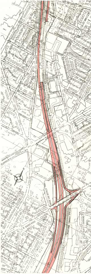 Interchange at New Hampshire Avenue
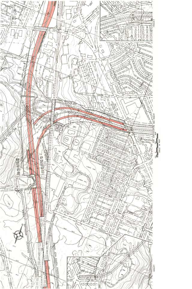 Retains the Fort Drive alignment for the I-95 Northeast Freeway from Maryland via Northwest Branch Park; but it realigns the North Central Freeway to the west, increasing its impacts on Fort Totten Park- hence creating a new objection.
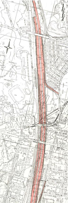
Entirely to the east of the railroad further south in Brookland, it avoided Turkey Thicket and Brooks Mansion, reducing the number of dwellings for the I-95 portion of the North Central Freeway to 69 houses (1910-20s vintage).

The 1966 supplementary study included the future addition of constructing a lid atop the depressed portion alongside Brookland, to make it a cut and cover tunnel.
Residences displaced DC/MD
1964 720/590
1966 372/163
The I-95 portion in D.C. from Fort Totten to the east would have taken 0 residences because it would have utilized the existing Fort Drive right of way previously reserved for the Intermediate Beltway Fort Drive
The I-95 portion of the North Central Freeway along the B&O railroad south of Fort Totten would have taken 69 houses at the western edge of Brookland, all south of Monroe Street and west of 10th Street NE, sparing Brooks Mansion to the north.
1966 North Central Freeway Supplementary Engineering Feasibility Report | B&O Route Low Level | B&O Route High Level |
| Washington, D.C. | ||
| Length | 4.33 miles | 4.33 miles |
| Configuration | 6 lanes from Maryland; 8 lanes south of the convergence of I-70S and I-95 at Fort Totten | 6 lanes from Maryland; 8 lanes south of the convergence of I-70S and I-95 at Fort Totten |
| ROW Costs | $39,700,000 | |
| Construction Costs | $66,558,000 | |
| Total Above Costs | $116,242,000 | |
| Residences taken | 372 | roughly the same |
| Population displaced | 1,250 | |
| Business locations taken | 89 | fewer businesses taken |
| Employment Displacement | 4,000 | |
| Initial Property Tax Base Loss | $8,943,000 | |
| Estimated Initial Property Tax Revenue Loss | $242,400 | |
| Maryland | ||
| Length | 3.38 miles | 3.38 miles |
| Configuration | 4 lanes from Beltway southwards to 16th Street; 6 lanes from 16th Street southwards to MD/D.C line. | 4 lanes from Beltway southwards to 16th Street; 6 lanes from 16th Street southwards to MD/D.C line. |
| ROW costs | $18,800,000 | |
| Construction Costs | $50,897,000 | |
| Total Above Costs | $77,332,000 | |
| Residences taken | 163 | |
| Population displaced | 488 | |
| Business locations taken | 70 | |
| Employment Displacement | 1,150 | |
| Initial Property Tax Base Loss | $5,537,000 | |
| Estimated Initial Property Tax Revenue Loss | $202,100 | |
| Full Route, Capital Beltway to Interchange "C" | ||
| Length | 7.71 miles | |
| ROW Costs | $58,500,000 | |
| Construction Costs | $117,455,000 | |
| Total Above Costs | $193,574,000 | |
| Residences Taken | 535 | |
| Population displaced | 1,738 | |
| Business Locations Taken | 159 | |
| Employment Displacement | 5,550 | |
| Initial Property Tax Base Loss | $14,480,000 | |
| Estimated Initial Property Tax Revenue Loss | $443,500 | |
| 1. Design Speed | Desired | Attained with 1966 I-70S/I-95 North Central Freeway |
| A. Freeway | 50 mph | 50 mph in D.C./70 mph in Maryland |
| B. Ramps | 25 mph | 25 mph |
| 2. Alignment | ||
| A. Horizontal Curvature | ||
| (1) Freeway (minimum) | 3 degrees | 7 -30'/3 -30' degrees |
| (2) Ramps (minimum radius) | 150 feet | |
| B. Vertical | ||
| (1) Freeway (Maximum Grade) | 3% | 4.0% |
| (Minimum Grade) | 0.5% | |
| (2) Ramps (Maximum Grade) | 6% | |
| (Minimum Grade) | 0.5% | |
| C. Sight Distance | ||
| Freeway (Minimum Stopping Distance) | 350 feet | 440 feet |
| 3. Roadway and Median Width | ||
| A. Freeway | ||
| (1) Lane width | 12 feet | 12 feet |
| (2) Median width | 7 feet min. | 7 feet |
| (3) Paved Outside Shoulder | 10 feet | 10 feet |
| B. Ramps (as proposed by A.A.S.H.O. design policy) | ||
| 4. Structures | ||
| A. Design Loads + H2) - S16 (44) including military requirement of the Interstate System | ||
| B. Minimum Vertical Clearances | ||
| (1) All Freeway Structures | 14 1/2 feet in D.C./14 1/2 feet in Maryland | |
| (2) Over Electric Railroads | 26 feet | |
| (3) Over other Railroads | 23 feet |
Official Indecisiveness to commit to 1966 plan
Nonetheless, a combination of indecisiveness amongst government officials, opposition to the earlier more destructive highway plans, as well as the idea of building highways elsewhere in D.C., following the 1960 cancellation of the Northwest Freeway, and highly effective protests organized by those opposed to any highways in favor of a strict transfer of construction funds towards speeding the completion of the Metro Rail WMATA network. While the 1966 B&O low level route was published that November, authorities stoked the flames of opposition by failing to commit to the newer plan, by suggesting that the 1964 Route #11 "Railroad East-Sligo" or even the 1964 alternative plans could be selected instead for a variety of reasons. A letter to Maryland Governor Spiro T. Agnew, from
Citizens of
We showed that the methods of traffic projections which were claimed tojustify the North Central were fallacious, the results in error by as much as 400 percent. Our contention was tacitly admitted in "re-studied" versions of the proposal made public last year, sharply reducing the original plan of 5 lanes each way.
The re-studied proposal also tacitly admitted that the route first proposed was needlessly, even carelessly if not ruthlessly, destructive of our communities. The new version hugged both sides of the existing
The reduced, re-routed proposal was made public last year with endorsement of D.C. And
Many of us were therefore astonished and aroused to preparations for renewed protests when
The result is that the whole controversy, which had been somewhat quiescent, is beginning to agitate the communities again. I can assure you this is so, for although I recently resigned chairmanship of the Metropolitan Citizens Council for Rapid Transit and write this simply as an individual citizen who wishes your administration well, I do remain in close touch with neighborhood sentiment on transportation-related issues.
As Governor of our State, you are in position better than we as private citizens to require straightforward answers from the Bureau of Public Roads.
You can also insure that the Maryland State Roads Commission refuses to go along with divisive proposals which these communities will regard as cause for new protests.
You can make yourself even better appreciated here by doing both, and by supporting the earliest and most extensive development of rail rapid transit. Will you do so?
Further Study:
1963-64 North Central Freeway Study
1963-64 North Central Freeway Study Report Plates
1971 Study
1971-73 PEPCO-B&O I-95
1964 North Central Freeway Routing Mystery
1962 JFK Administration Plan
The Original 1959 Washington, D.C. Northern Radials
Be sure to explore the tags, Highway Routing Mysteries, North Central Freeway and Grand Arc Mall Tunnel and others ...


No comments:
Post a Comment