Sunday, March 25, 2007

11th Street SE Bridges & Ramps


Subsequent planning at better connecting I-295 and I-395: building replacements for the 11th Street Bridge[s] that include full ramp connections at its southern end.

The existing 11th Street Bridge[s] were constructed during the 1960s.

These include full connections with the SE Freeway, both to the west (towards the I-395 SW Freeway and the I-395 Center Leg) and to the east (towards the East Leg to East Capitol Street.

They do not include connections with DC 295 to and from the north-east. That was because such traffic was to have a north-south North Central-Northeast Freeway as well as an east-west New York Avenue Industrial Freeway connecting to an I-66 K Street Tunnel.

http://www.ddot.dc.gov/ddot/cwp/view,a,1249,q,620301.asp
http://www.ddot.dc.gov/ddot/cwp/view,a,1249,q,627028.asp
http://www.ddot.dc.gov/ddot/cwp/view,a,1249,q,633384.asp

Opposition:

From the D.C. Sierra Club:
For years, DC residents have benefited from environmentally-friendly and community-sensitive planning by the District Department of Transportation (DDOT). Now, with their proposal their proposal to replace the replace the 11th Street Bridges, DDOT is proposing to spend up to half a billion dollars to add 50% more bridge capacity. The proposed project would destroy up to 12 acres of parkland and the Anacostia Community Boathouse. It would also effectively create an interstate highway shortcut through the District, adding thousands of cars and trucks to neighborhood streets each day and use up funding that could more effectively be spent on streetcars or bike and pedestrian saftey in our neighborhoods.

Read Sierra Club's comments on the Draft Environmental Impact Statement here.

Saturday, March 24, 2007

South Capitol Street Corridor Tunnel?


The South Capitol Street corridor tunnel would eventually connect the southern end of the Center Leg southward to resurface south of the River at a reconstructed partially underground interchange with I-295 and the Suitland Parkway. It would initially surface to connect to the existing I-395 SW/SE/Center Leg interchange, before a later project to build the full connections to and with a replacement future underground interchange.

DCDOT
USNCPC

This tunnel appears in the 2002-2003 planning studies for the South Capitol Street Corridor.


It appears with 6 lanes (3 in each direction).

These illustrations are from the 2003 South Capitol Street Urban Design Study (NCPC) and the Urban Gateyway Study (DCOP).

2003 NCPC South Capitol Street Urban Design Study

http://www.ncpc.gov/publications_press/Press_Releases/2003/pr060503_2.html

http://www.ncpc.gov/publications_press/s_cap/part_1.pdf
http://www.ncpc.gov/publications_press/s_cap/part_2.pdf
http://www.ncpc.gov/publications_press/s_cap/part_3.pdf

2003 DCDOP South Capitol Street Gateway Study

http://ddot.dc.gov/ddot/cwp/view,a,1247,q,560731.asp
http://ddot.dc.gov/ddot/frames.asp?doc=/ddot/lib/ddot/information/documents/frames/south_capitol/pdf/sc_cover.pd

USNCPC
Extending the Legacy: Planning America's Capital for the 21st Century

South Capitol Street-Frederick Douglass Mall

The version above with the linear park was for essentially the eastern half of the 1997 Extending the Legacy concept for what would logically be named the South Capitol Street-Frederick Douglass Mall, with the western half being omitted ostensibly to avoid displacing existing residences.


Such a swath of green space would be ideal for crafting an underground freeway, with the space to comfortably accommodate maintaining South Capitol Street traffic throughout the construction.

The 2003 USNCPC South Capitol Street Urban Design Study would proclaim its goal to:

Establish a linear park along the length of a new South Capitol Street that will
connect the Mall and Capitol Hill with the Anacostia River.


Nonetheless both the full and the half Mall proposals have since been precluded by the government's un-reported acquiescence to Roman Catholic Church hierarchy against demolishing or even relocating the St. Vincent de Paul Church at the northeast corner of South Capitol and M Streets (the only building on the northbound side to survive the redevelopment), as well as the placement of Nationals Ballpark Stadium.

This is the South Capitol Street Corridor Tunnel? because of the planning uncertainties of the physical realities that prioritize accelerated real estate development with ZERO consideration of increased construction costs and complexities, including an apparent failure to preserve open space for ramp connections to I-395.


See the series of posts I wrote in 2006 about this tunnel's feasibilities:


http://wwwsouthcapitolstreet.blogspot.com/2006_06_01_wwwsouthcapitolstreet_archive.html

And about the quiet betrayal of the U.S. Capital City's South Capitol Street-Frederick Douglass Mall:

http://wwwsouthcapitolstreet.blogspot.com/2006_03_01_wwwsouthcapitolstreet_archive.html
http://wwwsouthcapitolstreet.blogspot.com/2006_07_01_wwwsouthcapitolstreet_archive.html
http://wwwsouthcapitolstreet.blogspot.com/2006_08_01_wwwsouthcapitolstreet_archive.html
http://wwwsouthcapitolstreet.blogspot.com/

Thursday, March 22, 2007

I-395? New York Avenue Corridor


The I-395? New York Avenue Corridor extends from
the existing I-395 truncation at 4th Street NW through Washington D,C. NE to the Maryland line, continuing east as the Route 50 (un-signed I-595/Theoretical I-66) freeway. Since the "de-mapping" of the New York Avenue Industrial Freeway, this corridor has come under official re-study. This started with the November 19, 1996 New York Avenue Development Report commissioned by the Office of the D.C. Mayor (then under Mayor Marion Barry). The considerations include possible underground connections to the Washington, D.C. Convention Center to the north of Mt. Vernon Square, and the I-395? New York Avenue Tunnel to connect and presumably continue I-395 easterly beneath that avenue in a cut and cover tunnel extending at least to the vicinity of Florida Avenue. The tunnel would connect I-395 with the general area of interchange "B" that would have connected to northern, eastern and south to west choices.

The recent studies address both this tunnel as well as the New York Avenue corridor further east.

All of the options now officially considered would have the tunnel surface onto a New York Avenue "Boulevard" without connecting to a parallel railroad-industrial highway.

The reluctance of the recent New York Avenue corridor studies to answer the question whether the I-395 designation would be applied make this I-395?

Although these studies fall short in crafting a continuous traffic-light free connection, lest it benefit more people, they include two grade separated options for New York Avenue's intersections with Montana Avenue and with Bladensburg Road: elevated on a berm, or depressed beneath a circular lid that incorporates an SPUI interchange with the lid shape and outer walkways emulating the shape of a classic D.C. traffic circle.


SPUI (Single Point Urban Interchange) with circular lid atop depressed NY Avenue

However, this planning cheaps out by denying this grade separated treatment for Montana Avenue.

Wednesday, March 21, 2007

I-395? New York Avenue Tunnel


1996 D.C. Mayor's Office New York Avenue Revitalization Report

(Ron Linton)

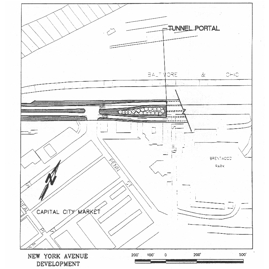
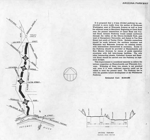
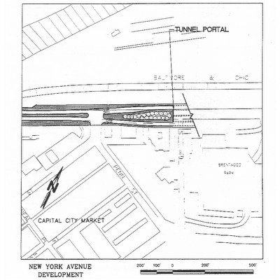
This basic tunnel plan appears in some official planning studies since its introduction of the New York Avenue Development Report of November 19, 1996, commissioned by the the Office of the D.C. Mayor of then D.C. Mayor Marion Barry, who had previously cut his political teeth as part of the anti-highway group ECTC -- the Emergency Committee on the Transportation Crisis -- in the 1960s and 1970s.

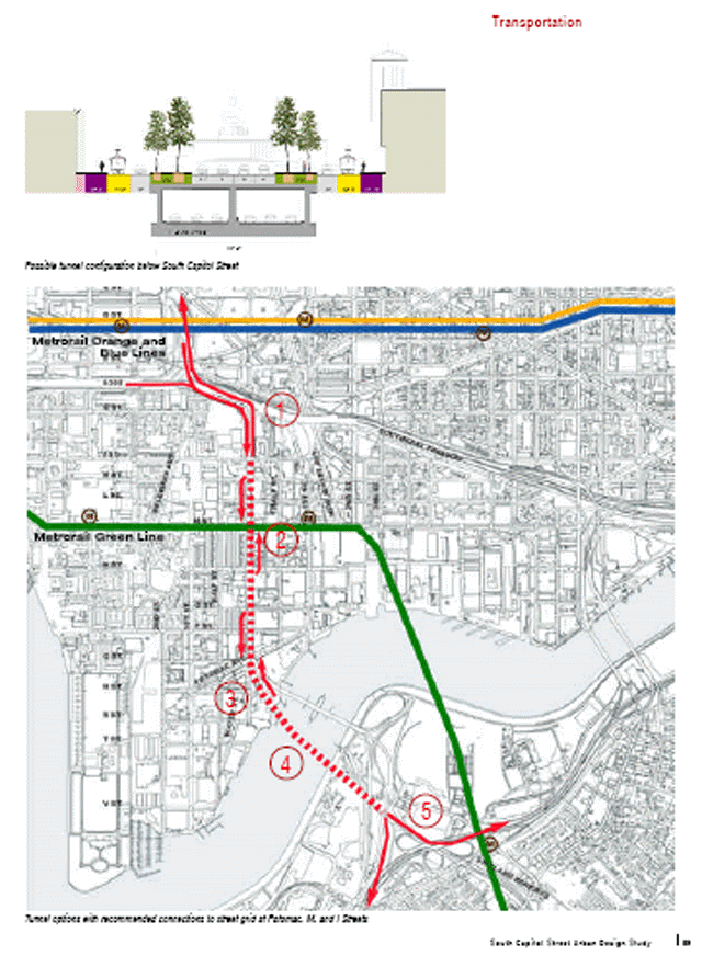
This tunnel design is cut and cover beneath New York Avenue.

This takes 0 dwellings, indeed 0 buildings, as opposed to the 600+ of the 1971 design I-95 (I-395) North Leg East.

However it provides a significantly tighter turning radii for the transition to and from the existing I-395 route that would wrap around the west (rear) side of the Bibleway Church complex. All of these recent studies follow this basic design with its tight transition.

This radii would otherwise be avoided for operation ability-safety issues regarding line of sight distances in a curved tunnel.

This proposed tunnel is I-395?, as the studies seem to go out of the way of avoiding answering the question whether it would actually carry the I-395 designation.

Indeed, the study seems afraid to consider constructing this tunnel as part of a continuous freeway- free of traffic lights.

The tunnel is considered in the context of accommodating a new WMATA rail tunnel:


Variants:

Authorities have proposed this tunnel in various lengths.

The 1996 study presented two tunnel length options:

2,100 feet long tunnel with 2 lanes per direction without shoulders and transitioning to surface near Florida Avenue ($340 million)

4,400 foot long tunnel extending to 6th Street NE with 2 lanes per direction with 8 foot right shoulders ($600 million),

A 1998 proposal extended this further east to Montana Avenue NW.

Subsequent studies however have look at a shorter tunnel that ends to the west of Florida Avenue NE, closer to North Capitol Street then the 2,100 foot proposal.

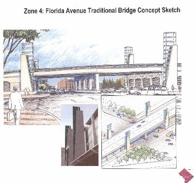
This would then have either a traffic light intersection with, or a raised roadway and bridge over Florida Avenue.

I-395? Overpass at Florida Avenue for post 2000 short tunnel option

From The Washington Post: New York Ave. Traffic Plans Spark Concerns: D.C. Residents React To Draft Proposals; by V. Dion Haynes, Washington Post Staff Writer, Sunday, June 26, 2005; Page C01

Mary Ann Wilmer, 66, who lives near New York Avenue in Northwest Washington, said something must be done to ease rush-hour traffic from I-395. She said it routinely takes her 20 minutes to travel three blocks.

Still, she said in an interview, the overpass "is not very aesthetic. . . . Those concrete barriers sitting up there -- I don't think that will do."

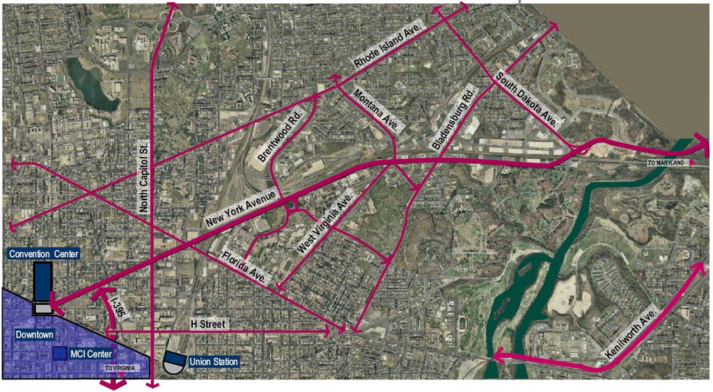
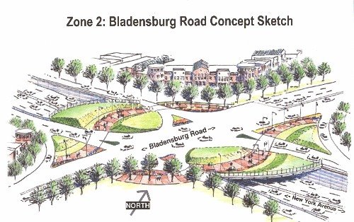
Transportation officials are proposing $1.2 billion worth of projects to ease traffic in a five-mile stretch of the corridor, which often is jammed by a confluence of vehicles from the interstate and neighborhoods. They said the area has nine of the city's most congested intersections, including New York Avenue at Bladensburg Road in Northeast.

"New York Avenue is a very dangerous place. We want to make it safe," Rick Rybeck, the Transportation Department's deputy administrator for transportation policy and planning, told more than 30 residents yesterday at the Frank D. Reeves Municipal Center in Northwest.

Daily, 127,000 vehicles travel on New York Avenue as it crosses the D.C.-Maryland border, the Transportation Department said. Citing population increases and new development, transportation officials predict traffic will worsen.

http://www.washingtonpost.com/wp-dyn/content/article/2005/06/25/AR2005062501097.html

Popular favor for a longer tunnel extending east of the B&O/WMATA Red Line railroad corridor has led to a 2006 D.C. government study of an "extended tunnel" concept that would be almost as long as the initial 1996 long tunnel, but with a grade of 7% grade rather then 5%. This extended tunnel is studied with two variants: one with and one without access ramps between North Capitol Street and Florida Avenue NE.

This variant like all of the others has the tunnel simply surface onto New York Avenue and does not include consideration of having its alignment swing to meet a grade separated I-395 extension along the parallel railroad corridor.

East Portal: 1996 Short Tunnel Option


East Portal: 1996 Long Tunnel Option


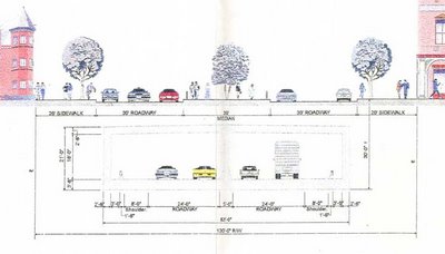
I-395? New York Avenue Tunnel Cross Section

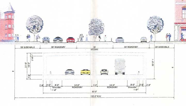
The plan is artificially constrained regarding capacity. New York Avenue is sufficiently wide to fit such a tunnel with up to 7 lanes plus shoulders. (See the illustration above; note that the dimension lines to the left mark this tunnel's wall with three lanes rather then only two).

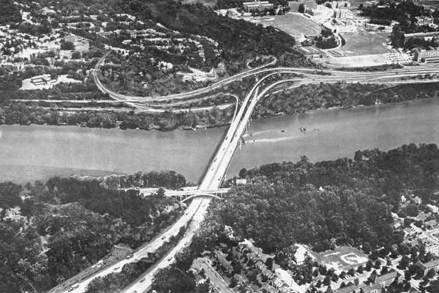
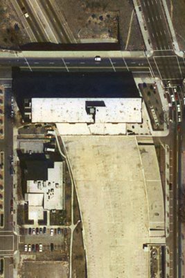
The existing north-south I-395 accommodates 6-8 lanes, with the tunnel extension between Massachusetts Avenue and K Street having non-load bearing knock-out walls (see the expansion joints on K Street showing this I-395 tunnel's true width in the photo below).

This restriction of only 2 lanes in each direction, whether for the existing, I-395 or for the proposed New York Avenue tunnel saves zero dwellings.

It is further constrained for being considered only as an extension from I-395. Although the 1996 proposal includes a set of tunnel ramps to the west, to an underground connection into the new Convention Center just north of Mt. Vernon Square, it does not include stub connectors to a revived I-66 K Street Tunnel proposal.

Indeed, U.S. National Capital Planning Commission has nothing of the sort in its latest planning regarding K Street. (PDF link)


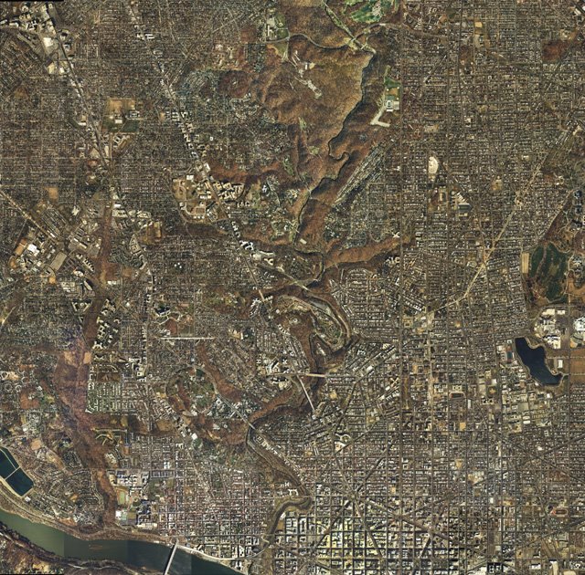
Images produced by National Capital Planning Commission for the Washington Geographic Information System. Distributed by VARGIS LLC of Herndon, VA.

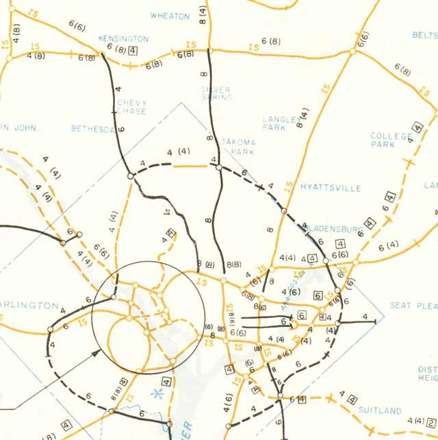
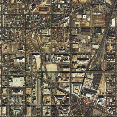
Note the proximity of Washington, D.C.'s I-395 with the two main railroad corridors that both continue into Maryland.

As currently dictated, the project seeks to serve fewer rather then greater numbers of people and goods. It says nothing about time-savings, nor the environmental-footprint benefits of a highway tunnel, while adhering to a dogma against through traffic.

I-395 Tunnel: A Superior Option


Current studies:

http://www.ddot.dc.gov/ddot/cwp/view,a,1247,q,560773.asp

http://www.ddot.dc.gov/ddot/frames.asp?doc=/ddot/lib/ddot/information/studies/newyork/task11memo/extendedtunnel_techmem_2006-07-13.pdf
http://www.ncpc.gov/whats_new/2006/NY%20FLA%20charrette.11.06.pdf

Tuesday, March 20, 2007

Barney Circle Freeway & Bridge Project

The Barney Circle Freeway project was officially planned from 1983 into 1996.

It consisted of a 6 lane eastern extension from the SE Freeway underpasses beneath Barney Circle at Pennsylvania Avenue SE to a split with a 4 lane mainline continuing over the river to connect with D.C. 295, and with 1 lane per direction on a roadway to R.F.K. Stadium and the East Capitol Street Bridge. An earlier design had that with 2 lanes per direction, which was in explicitly scaled back to serve fewer people.

PLANNING:

It was the outcome of a study that had considered 4 alternatives:

Alternative 1: A new freeway alignment connecting the SE Freeway with East Capital Street. (RFK Stadium Access Road Route)

Alternative 2: A new freeway alignment connecting the SE Freeway with a bridge across the Anacostia to connect with the Anacostia Freeway. (New Freeway Bridge)

Alternative 1/2: An incorporation of elements from Alternatives 1 and 2, with a freeway extension from the SE Freeway via the above mentioned bridge, plus a set of ramps just before this bridge, for a connection to East Capital Street. (RFK Stadium Access Road Route with New Freeway Bridge)

Alternative 3: New ramps at the Pennsylvania Avenue/Anacostia Freeway interchange to accommodate southbound Anacostia Freeway traffic to the SE Freeway, and SE Freeway traffic to the northbound Anacostia Freeway. (New fly-over ramps at Pennsylvania Avenue to Anacostia Freeway)

This evaluation by the DCDPW, the Federal Highway Authority and the Barney Circle Steering Committee eliminated the following alternatives:

Transit option: Metro rail and bus would not meet the total measure of traveling needs, nor alleviate truck traffic on local streets.

2 variations of a tunnel option, due to technical design difficulties associated with geological and hydro logic conditions, severe construction impacts, the need to accommodate existing utilities hence requiring expensive design solutions and visually obtrusive ventilation shafts.

6 variations of interchange modifications involving new ramps at the Sousa and the 11th Street Bridges because they would require either (a) taking active developed parkland and recreation areas; (b) displaced a maximum of 15 businesses and 148 residences at the Pennsylvania Avenue/Anacostia interchange; (c) substantially impact other roadways or bridges with large structures that would still not ideally handle projected traffic volumes; and (d) focus visual impacts upon residential and commercial areas next to already heavily traveled freeway sections.

This 1983 Selected Alternative was the result of a study of FEIS alternatives initiated in 1981 by the D.C. Department of Public Works.


It was the sole freeway project planned for Washington, D.C. for about a decade and a half following the wholesale freeway "de-mappings" of I-70S, I-95, I-66, Theoretical I-66/Route 50, I-295 and I-695.

LAW SUIT:

It became the object of a law suit in 1993 arguing parkland impacts including the disturbance of contaminated soil. This suit was filed by the Sierra Club Legal Defense Fund against FHWA to get basic information about how this project would affect their lives, and alleging that FHWA violated the Clean Air Act, Intermodal Surface Transportation Efficiency Act (ISTEA), and Section 4(f) of the Department of Transportation Act (which prohibits the construction of federal highways through park land where prudent and feasible alternatives exist). According to Fern Shepard, an attorney with the Sierra Club Legal Defense Fund, the Barney Circle Connector was
"a proposed federally-financed freeway that will run adjacent to the Anacostia River, cutting through neighborhoods and park lands in southeast Washington, D.C. Ms. Shepard explained that southeast Washington is overwhelmingly African American and middle-to-low-income. The city's highest poverty rates are in this area. In her opinion, the construction of this freeway would have many severe environmental impacts, including:

Excavating 70,000+ tons of lead-contaminated soil adjacent to residential neighborhoods; Adding 80,000+ cars and trucks, driving at freeway speeds directly adjacent to residential neighborhoods. This will add substantial air pollution (about 170 tons a day) and noise pollution to these neighborhoods and decrease property values; Paving over 17 acres of scarce park land and adding the sixth interstate bridge over the Anacostia River, the most endangered urban river in the country; and

According to Ms. Shepard, this freeway construction was unnecessary since the missing freeway links can be supplied with low-cost, low-traffic, neighborhood- and park-protecting ramps. Ms. Shepard explained that the Barney Circle Connector would cost the federal treasury more than $200 million to construct, at a time when the District's fiscal crisis already has resulted in severe cutbacks in city bus service and increases in transit fares. With the assistance of Joseph Passonneau, recipient of the 1993 Civil Engineering Award for Most Outstanding Highway Design, an alternative plan was developed, featuring overhead ramps at the Pennsylvania Avenue SE interchange with the Anacostia Freeway to the south of the Anacostia River, which Ms. Shepard is persuaded would address the FHWA's concerns regarding missing highway links; at a fraction of the cost of the Barney Circle Connector, disturbing less than two acres (as compared to 17 acres) of park land without bisecting the park; it would not require the excavation of hazardous wastes; and it would not disturb homes or businesses (something also true with the Barney Circle Connecter). The lawsuit against the Project would receive further assistance by the Georgetown University Law Center's Institute for Public Representation, the National Resource Defense Council, and the prestigious Washington, D.C. law firm Covington and Burling."
The project had the support of D.C. Mayor Barry who submitted in October 1996, the first of several of its contracts to the City Council for its approval.

CANCELLATION

In response to Mayor Barry's submission of construction contracts, Council-member Chavous, with support from Councilmember Mason, introduced a bill to disapprove, which passed on December 3, 1996 by a Council vote of 12-1 for a $15 million contract.

By March 5, 1997 the Barney Circle Connector was declared politically dead by D.C. Congressional Delegate Eleanor Holmes Norton, who announced her support for its cancellation and the transfer of its funding for other things.


Barney Circle Bridge underpass to R.F.K. Stadium

Sunday, March 18, 2007

Georgetown's Waterfront Freeway Corridor & Connections

Georgetown Waterfront, Glover-Archibold Park, and portion of Canal Road
Image produced by National Capital Planning Commission for the Washington Geographic Information System. Distributed by VARGIS LLC of Herndon, VA.
This consists of the Whitehurst Freeway along the downtown Georgetown waterfront to K Street, and its various proposed upgrades and extensions proposed to go to the north, northwest:, and west: aka, the Glover-Archibold Parkway, the George Washington Memorial Parkway (to Maryland's Clara Barton Parkway and the I-495 Capital Beltway); and the Three Sisters Bridge.

Generally, the focus is solely upon the Whitehurst, despite its short length and its disconnect with the freeway system symbolized by its northern ending in the vicinity of the staircase near Georgetown University famous to many people for its appearance in the1973 movie "The Exorcist."

The Whitehurst Freeway:

Built late 1940s, prior to the 1956 U.S. Interstate Highway Act, hence the Whitehurst is built to a lower standard of design relative to the later highways designed as interstates.

According to Steve Anderson's Whitehurst Freeway entry in D.C. Roads:
H.C. Whitehurst, who was director of the District Highway Department, conceived the skyway that eventually bore his name. He designed the K Street Skyway as the first piece of a long-range, district-wide plan to build freeways through Washington and its neighboring suburbs. Whitehurst, who was an early booster of the Interstate highway system as chairman of the American Road and Transportation Builders Association (ARTBA), died while the freeway was under construction. The Whitehurst Freeway was named for the former highway chief after his death.

The District awarded the construction contract to Archibald Alexander, a pioneering black engineer who worked his way up at Marsh Engineering on projects such as the Tidal Basin Bridge and seawall during the 1910's and 1920's. Alexander eventually founded his own firm specializing in bridge design and construction, which carried out the contract.

ALONG THE POTOMAC, WASHINGTON'S FIRST FREEWAY GOES UP: The Whitehurst Freeway was built to what were contemporary standards in the 1940's, but far short of Interstate standards. The four-lane freeway was built without shoulders and had a design speed of only 30 MPH. Exit ramps also were of substandard design. Because the freeway was to be built directly above K Street, very little demolition work was necessary. However, there was one notable exception - the home of Francis Scott Key, the author of the poem that became the Star-Spangled Banner - that was torn down for the western terminus of the freeway.
The corridor is subsequently considered to be upgraded and extended to interstate highway specifications in a number of studies, including the1957 North West Freeway study "A Report of the study on the location of Interstate U.S. Route 240 Washington, D.C. which considered 3 options of which a portion would utilize this corridor:


Route A: Palisades trolley alignment to Inner Loop via expanded elevated Whitehurst Freeway: 4.57 miles
Route A-2: variant of Route A Palisades trolley alignment with narrower footprint north of ChainBridge to Inner Loop via an expanded elevated Whitehurst Freeway: 4.57 miles
Route C: Wisconsin Avenue corridor to Glover Archbold Park to Inner Loop via expanded elevated Whitehurst Freeway: 5.65 miles
The subsequent 1959 North West Freeway proposal had a separate inland connection to the Inner Loop for I-70S to supplement a Glover Archibold Parkway: both if which were effectively canceled by 1962.

The Glover-Archibold Parkway

This appears in 1952, as a parkway that would not allow trucks.
The 1957 North West Freeway study includes the option of an interstate highway version to connect to an interchange at the foot of Glover-Archibold Park next to Georgetown University with an expanded extended Whitehurst Freeway.
Illustrations from 1957 publication "Should Glover-Archibold Park Be Destroyed"

1959 Mass Transportation Plan
The 1959 Mass Transportation Plan has the Glover-Archibold Parkway serve as both a radial to and from I-70S at a split to the south of Tenley Circle, and as a segment of the circumferential Fort Drive Intermediate Beltway.
1939 Fort Drive
The Clara Barton/George Washington Memorial/Canal Road Parkway
The George Washington Memorial Parkway was planned to run along both sides of the Potomac River to and from the I-495 Capital Beltway, yet was completed only on the Virginia side.
The segment in Maryland connecting to the Capital Beltway was constructed continuously with 2 lanes in each direction to a point where it transitions to a single 2 lane roadway, and then to a brief 4 lane divided segment before again reverting to a single lane in each direction near the Maryland/District line.
The Three Sisters Bridge
This bridge, named for the trio of rocks in the river, would have connected Virginia and Washington, D.C. respectively at the foot of Spout Run and Glover-Archibold Park. It appears in the 1959 Mass Transportation Plan. As an extension from the Glover-Archibold Parkway that would connect to inside the beltway I-70S at a split to the south of Tenley Circle, it would serve to facilitate traffic from I-70S and the circumferential Fort Drive Intermediate Beltway to and from Virginia.

It disappears, along with the Glover-Archibold Parkway and the entire NW segment of the Intermediate Loop in the Administration of U.S. President John F. Kennedy's November 1, 1962 "Recommendations for Transportation in the National Capital Region; A Report to the President for transmittal to Congress by the National Capital Transportation Agency."

The Three Sisters Bridge would subsequently reappear as part of an I-266 project connecting I-66 in Virginia and Washington, D.C.
It had more then one study.

Proposed I-266 Three Sisters Bridge looking from Virginia to Washington, D.C. with Georgetown University at upper right.

The plans from the 1950s would have had an inland continuation of a Glover-Archibold Parkway. via that swath of green of Glover-Archibold Park to the left of Georgetown University.

Under such plans, the Glover-Archibold Parkway and the Three Sisters Bridge were to be a part of Washington, D.C.'s Intermediate Beltway/ Fort Drive Parkway.


From Scott Kozel's Roads to the Future:
A construction contract was begun in 1972 for the Three Sisters Bridge substructure, but the contract was suspended by a court injunction several months later, and then cancelled a few months later by DC DPW. That happened at the same time that a court injunction stopped the design process on the I-66 extension in Virginia from the I-495 Capital Beltway to the Theodore Roosevelt Bridge. The design process for I-266 never restarted, while a revised 4-lane version of I-66 was placed under construction in 1977 and opened in 1982. Details are on my I-66 article Interstate 66 and Metrorail Vienna Route. See Mike Hale's article Interstate 266 Unbuilt.


The Three Sisters Bridge became colorfully protested, with protesters that camped out on the three sisters to thwart the construction.

The law suit would be handled by Covington & Burling, which later sued against a 12 lane Woodrow Wilson Bridge (and in other suits, against the North Central Freeway, the East Leg to East Capitol Street, and the later Barney Circle Connector), with the assistance at various times with the Georgetown Law Center (Georgetown University Law School), and the D.C. Sierra Club.