Senior Counsel, Juvenile Justice Clinic, Lupo-Ricci Professor of Clinical Legal Studies
B.S., Northwestern; J.D., Georgetownnote- Georgetown Law is situated directly alongside
the now under constriction segment of the I-395 Center Leg
see: http://wwwtripwithinthebeltway.blogspot.com/2017/03/a-crime-in-washington-dc.html

Why is that ditch there anyway?
by Wallace Mlyniec
A generally good piece, though misleading and erroneous on the cross-town I-66 link
with a few errors- see notes.
https://www.google.com/url?sa=t&rct=j&q=&esrc=s&source=web&cd=4&cad=rja&uact=8&ved=0ahUKEwi9nMySmYzTAhVr1oMKHV9MDXgQFggsMAM&url=https%3A%2F%2Fwww.law.georgetown.edu%2Fcampus-services%2Ffacilities%2Fconstruction-info%2Fupload%2F2014-6-11-Why-is-that-ditch-there-anyway.docx&usg=AFQjCNEdjfTNlUiIZ-W5xTazLxf3atoCsg&sig2=xaYLuwmxU8SsVgqlBFiEGQ&bvm=bv.151426398,d.cGc
Dear colleagues,
As you have undoubtedly noticed, the utility phase of the Capitol Crossing project has begun. Backhoes are digging trenches twenty-feet deep and metal supports are being lowered into the trenches to prevent collapse as workers install and connect sections of a new sewer line to take storm water and waste water away from the neighborhood. I will be reporting more about those lines in another email; but today, as you look at the work going on and the highway behind it, you may be asking yourself, “Why is that ditch there anyway?”Any modern urban planner looking at the I-395 ditch that bisects the East End of downtown probably recoils in horror and wonders why anyone would deliberately create such a fissure in the urban landscape. Such modern thinking, however, has not always permeated city planning.The post-World War II prosperity changed the habits of the vast majority of Americans. Wages rose, home ownership became more common, and suburbia seemed to expand in every direction. Cities became places to work and visit but they were no longer considered the primary place to live. People moved farther from the central cores of cities and their geographic horizons expanded. They discovered new places to explore, places they had only heard of before, and they now had the money to do so. Moreover, the also had the means because the automobile had liberated middle-class America.Post-War Americans fell in love with the automobile in ways that were different from before the War. Although Henry Ford and his twentieth-century assembly lines made cars easier to make and somewhat affordable, America’s post-World War II prosperity made those cars affordable and accessible to more people. A car of one’s own became every man’s and every woman’s birthright. Coming of age for teenagers meant getting a driver’s license. The cars themselves became works of art, each distinctive in style from those of other manufacturers. Ford, General Motors, and Chrysler created multiple brands and multiple lines within brands. Detroit hummed, producing cars of status like Cadillacs, Mercuries, Packards, and Imperials; but they also made more affordable cars like Ford Fairlanes, Chevys, and Plymouths for middle class Americans. Unlike today’s cars, the cars of the 1950s and 1960s were beautiful and instantly recognizable. You can see some of the classics if you visit
This love affair with the automobile and the desire for fast and convenient travel spawned President Eisenhower’s U.S. Interstate Highway System, considered by many to be the greatest public works project in modern history. As a young officer in 1919, Eisenhower traveled with a convoy of trucks from San Francisco to Washington. The trip took 62 days which gave him plenty of time to notice that there were seldom places to eat, sleep, or repair broken down vehicles along the way. Eisenhower never forgot the rigors of that convoy. His war experiences also impressed upon him the need for good transportation across the land. These experiences, combined with a Cold War defensive mentality, resulted in the passage of the Federal-Aid Highway Act of 1956. The Pennsylvania Turnpike, opened to traffic on October 1, 1940, was then the prototype of the modern, high-speed interstate highway. It, along with the then highly profitable Hutchinson River and Merritt Parkways in New York and Connecticut, were incorporated into the interstate system at the time of its creation in 1956. More freeways and toll roads were soon built or while existing ones were integrated into the Interstate System. Today, the Interstate Highway System comprises 46,876 miles of concrete. For more fascinating information about the Interstate System, visit
America’s love affair with the automobile and the coming of the Interstate Highway System combined to make travel in and out of a city easy; but it also altered the notion of urban planning and ultimately led to the I-395 ditch. Although it is sometimes disputed, most urbanists today would say that planning in the late 1940s and 1950s was focused on transforming the built environment of the country to a suburban form, while at the same time, devising the most efficient way to move cars in, out, and around a city. The District of Columbia was not immune from these influences. Despite the departure of many government employees who supported the war effort, the population of Washington had soared to over 900,000 by 1950. (By the way, today’s D.C. population is only 632,323.) In that same year, the population in the metropolitan area exceeded 1.5 million. Although retailers saw their customers abandoning the inner city for the far edges of the District and for the newly emerging suburbs, the demand for downtown office space accelerated as trade associations, educational societies, and national planning groups recognized that the Federal government intended to retain its primacy in the affairs of the nation and the world. In 1950, there were over 600,000 civilian jobs in Washington, D.C., twice the number there had been in 1940. The police complained that the overwhelming number of cars coming into the city interfered with crime fighting activities. Suburbanites, driving into the city to work, found the city streets congested and difficult to maneuver. Despite their new prosperity and well-being, the suburbanites and the locals were not happy when behind the wheel in the city.The National Capital Park and Planning Commission, authorized by Congress in 1945 to rebuild Washington's deteriorated neighborhoods, was beset by lobbyists from many special interest groups, each with a grand plan to end the blight and revitalize the city. Among the more powerful were local transportation officials and the sellers of the beautiful and affordable automobiles. They demanded that transportation within and around the District of Columbia be improved. At first they were extremely successful. In 1947, the Whitehurst Freeway began to move commuters around the congested lower Georgetown area. In 1948, century-old elm trees were destroyed to build the DuPont Circle Underpass that would ease automobile traffic and serve the city's busiest trolley line. The Capital Beltway, originally called the Circumferential Highway, was also designed in the mid-1950s. Its first segment, which included the Woodrow Wilson Bridge, was completed in 1961. The entire 64-mile highway was completed in 1964, at a cost of $190 million. America was moving on wheels and D.C. was not going to be left behind.The Center Leg Freeway was part of a larger project called the Inner Loop, which itself was part of an even larger scheme to reroute traffic along several corridors through the city and then out to the developing Capital Beltway. The Inner Loop had several segments. The South Leg was designed to run along the Potomac River, connecting a new Southeast Freeway, the 14th Street Bridge, and the new Theodore Roosevelt Bridge, before turning towards Georgetown. There it would connect with the Potomac River Expressway, a new highway that would be paved over the historic C & O Canal. The last part of this plan was eliminated after Supreme Court Justice William O. Douglas challenged highway proponents to walk the entire length of the Canal with him and to discover and then preserve its natural beauty. The East Leg was to have begun at the new Anacostia Freeway, cross the 11th Street Bridge, and proceed along 11th Street near Lincoln Park on Capitol Hill to Florida Avenue. If completed, it would have destroyed a beautiful group of row houses on 11th Street S.E., now called Philadelphia Row, built by Charles Gessford between 1865 and 1867. At Florida Avenue, the loop would turn west and follow along T Street until it turned south above DuPont Circle to join up in lower Georgetown with the Potomac River Expressway. Another proposed highway, called the Northeast Freeway, would have commenced on the East Leg at Florida Avenue, and then continue along the railroad tracks to Silver Spring. Other features proposed at one time or another were an I-66 leg going up K Street from the East Leg to Georgetown, crossing a new bridge over the Potomac River at the Three Sisters Islands, and then proceeding along a new North Leg on 16th Street. [sic*]Planners also proposed an expressway along Missouri Avenue [the Intermediate Beltway, along the route previously proposed for the Fort Drive Parkway] and another, called the Industrial Parkway, that would have run along New York Avenue and then to Baltimore via the new Baltimore Washington Parkway.
---------------
[*sic - This description is potentially confusing. It is either:
- a vague mention of a later plan that appeared during the mid 1960s for the cross-town I-66 link, within a paragraph that describes the freeway system as planned during the latter 1950s.
The initial plan was for the cross-town I-66 North Leg to run from the west as an open trench freeway continuing from the I-66 West Leg that would be constructed during the early 1960s in the vicinity of today's Kennedy center and the Watergate complex, northerly alongside Florida Avenue and then easterly between U and T Streets to an interchange with the planned northern end of the open trenched Center Leg Freeway alongside New Jersey Avenue. An eastern extension of the North Leg, continuing upon an elevated berm, would continue to the vicinity of Gallaudet University to meet the northern end of the open trenched East Leg at 11th Street NE.
Opponents to that plan as Elizabeth Rowe by 1965 offered the alternative idea of constructing the cross-town I-66 North Leg via a tunnel beneath K Street, eastward from Georgetown to the Center Leg, and refined by 1971 taking advantage of the geometry by placing the crosstown I-66 tunnel's western approach beneath Pennsylvania Avenue just west of Washington Circle, continuing beneath K Street to the vicinity of Mt Vernon Square and then to its eastern approach tunnel beneath and partially offset to the north of New York Avenue. The I-66 North Leg would be an essentially east-west route; 16th Street which is a north-south road was never proposed for the east-west North Leg]
- Or, given its linking phrase "crossing a new bridge over the Potomac River at the Three Sisters Islands and then...", the whole sentence should instead read "Other features proposed at one time or another were an I-266 leg from the West Leg along a widened Whitehurst Freeway (which is along the K Street axis in Georgetown) , crossing a new bridge over the Potomac River at the Three Sisters Islands, and then proceeding alongside the Spout Run Parkway in Virginia to connect with I-66.
--------------------
MAP OF THE PROPOSED D.C. HIGHWAY
SYSTEM [*]
[*Mlyniec's paper describes the Washington, D.C. freeway system via the plans from the Inner Loop Engineering Study report from 1955, yet shows the system as later vastly re-routed as illustrated from the "Summary of Comparison of Alternative Systems District of Columbia
Interstate System 1971 by Deleuw, Cather Associates, Harry Weese
& Associates, Ltd."
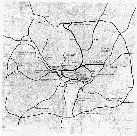
[Washington, D.C. Freeway System as proposed in 1971]
[BELOW: the Initial and Revised Proposals for the D.C. regional freeway system,
downtown Inner Loop,
and the Inner Loop's North Leg (west) cross-town I-66
downtown Inner Loop,
and the Inner Loop's North Leg (west) cross-town I-66
added by Douglas A. Willinger/A Trip Within The Beltway to better present the story.]

Washington, D.C. Freeway System
as proposed cir.1958

Washington, D.C.

Washington, D.C. Inner Loop I-66 North Leg (west)
with I-95 (now I-395) Center Leg extension at bottom right,
with connecting interchange at New Jersey Avenue and T Street.
While these two freeways were to be depressed below street level,
the I-95 North Leg (east) at the right was to be elevated.

Washington, D.C. Inner Loop I-66 North Leg (west)
as proposed in the 1971
"Summary of Comparison of Alternative Systems District of Columbia Interstate System 1971 by Deleuw, Cather Associates, Harry Weese & Associates, Ltd."
Fearful that the highways would diminish the grand views contemplated by Pierre L'Enfant and George Washington, the planners intended to depress [*sic] the highways below the surface of the city. The Mall would be spared by a tunnel running under the Lincoln Memorial. Each Leg of the Inner Loop would be built below the streetscape and bridged at strategic points. E Street would have a tunnel from 6th to 13th Street, N.W. It would have actually run under the White House. Depressed tunnels were also planned for portions of 9th 12th and 14th Streets. Remnants of this depressed highway system exist today as the E Street Expressway and Virginia Avenue near the Kennedy Center in Foggy Bottom, and at the Center Leg Freeway west of the Law Center. Obviously, such a system would have cut the city into several enclaves isolated from each other by highways, at least until decks could be built over some of them. The old Capitol Hill neighborhood provides an example of how this plan would have degraded the city. The original Capitol Hill neighborhood developed on the banks of the Anacostia River when President John Adams established the Navy Yard. It then grew to the north along 8th Street, S.E. The Eastern Market, a Capitol Hill landmark located today at 7th and C Streets, S.E., was originally sited at about 5th and K Streets, S.E., between the Navy Yard and the emerging Capitol Hill residential neighborhood. Today, the Southeast Freeway, elevated rather than depressed, divides the Capitol Hill neighborhood at Virginia Avenue, hampering efforts to enhance the old 8th Street commercial district and connect the neighborhoods south and north of the highway.
[*sic- its should read "... some of the highways..." Although the trenched 11th Street East Leg and the Center Leg next to Georgetown Law Center are correctly described, and the author makes the useful observation that these could be eventually decked (covered) over, he only mentions that the Southeast Freeway is elevated rather than depressed, nor that is only so west of 11th Street (the portion to the east sitting on the surface at a sufficiently low where the topography descends towards the Anacostia to permit erecting a deck atop.grade to permit. He fails to mention that the adjourning segment of the Southwest Freeway is also elevated, and so was the portion of the 1950s design proposal for the North Leg to the east of its connection at New Jersey Avenue with the northern end of the Center Leg.]
I invite Wallace Mlyniec and his readers to learn about the history and designs of the Washington, D.C. freeway system, as built and as proposed through this blog of mine that I started nearly a decade ago "A Trip Within The Beltway".The Center Leg Freeway, developed in our East End neighborhood in the 1950s and approved in 1964, was even more devastating to the D.C. urban landscape. By the time the existing portion was completed in 1973, over 400 dwellings were demolished and more than 100 businesses and 1600 residents were displaced. When the Law Center moved to this neighborhood in 1971, the East End was a virtual ghost town. A future email will discuss the devastation of this old, primarily Italian, but integrated neighborhood.
Notwithstanding the approval of the Center Leg Freeway, it was never completed. The portion of the Center Leg that was completed ran a mere 1.4 miles from the Southeast Freeway interchange to Massachusetts Avenue. It was 22 feet below sea level, with a tunnel under the Mall that ran 3,500 feet. Costing $81 million (1972 dollars), it was reputed to be the most expensive highway ever built at the time. It was also the most technically complex. Despite its technological complexity, it became a highway to nowhere.
Most of the Inner Loop plan was scrapped after years of controversy. Lawsuits by the Committee of 100, the D.C. Federation of Civic Associations, and other civic groups, protests by activists like Sammy Abbot and Peter Craig, the demand for a new subway transit system, and the obvious racial discrimination associated with the plan ultimately resulted in its demise. Still, remnants remain. The road along the Potomac River and around the Lincoln Memorial that connects Independence Avenue with the Rock Creek Parkway and the E Street Expressway were built as a compromise. The Theodore Roosevelt Bridge, the Southeast Freeway, the Anacostia Freeway, and the depressed Virginia Avenue in Foggy Bottom are a few parts of the original plan that still exist. Old arguments about parts of the plan resurface from time to time. Debates continue about the existence of an interchange at Barney Circle on Pennsylvania Avenue, S.E., and Virginia legislators still dream of a Three Sister's Bridge. As for the Center Leg, the highway beyond Massachusetts Avenue became a parking lot until 1982 when it was extended to K Street. The extension, however, did nothing to change its fate as a relic from the past. Now that relic will continue its limited purpose but it will disappear from view, buried beneath the new Capitol Crossing project.
The intense and prolonged resistance to the Inner Loop ultimately saved the L'Enfant Plan. Saving it turned out to be critical to the urban renaissance that downtown Washington is experiencing today. For the next eight years, we will be eye witnesses to that renaissance. We will have a close up view as the East End neighborhood is reconnected to the downtown and a part of the original L’Enfant design is reestablished. The ditch will remain but it will be covered by a seven acre deck replete with modern buildings, new residents, and new businesses. I intend to chronicle that journey in the coming years so that you can share in the exuberance of this extraordinary urban project. Stay tuned.
-------------


