new demolition specials upon the northbound un-built D.C. B&O Route I-95 right of way,
with more being planned
see:
http://wwwtripwithinthebeltway.blogspot.com/2015/01/choking-dc-b-grand-arci-95-corridor.html
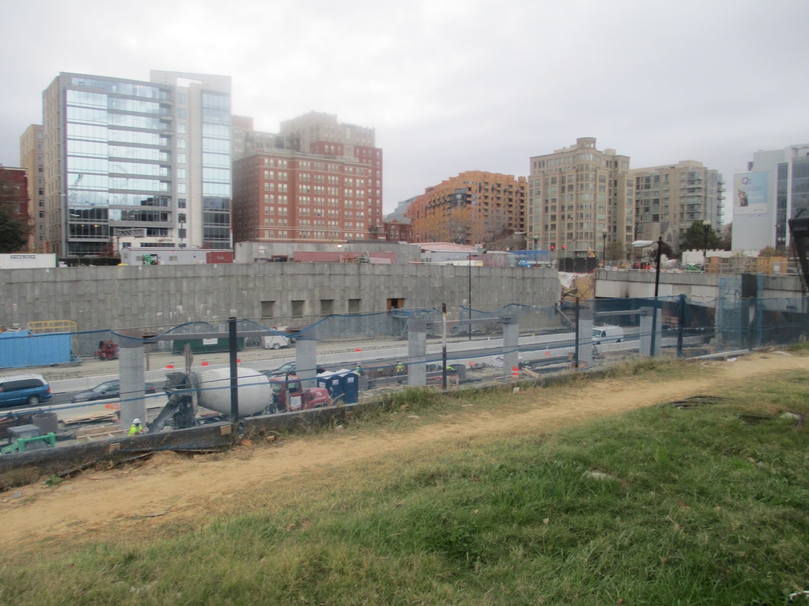
looking northwest from corner of Kearney and 9th Street - 2 projects:
in foreground- Townhouses at 3300-3314
and
in background - Office building at 3350 - currently under construction
New buildings now being constructed and planned along the east side of the B&O corridor and west of 9th Street NE, northward from Kearney to Lawrence Streets - directly in the path of D.C. B&O I-95 that had been canceled
as the result of the 1960s era political planning manipulations.
Previously posted at this blog about this misguided development thrust:
http://wwwtripwithinthebeltway.blogspot.com/2013/12/cua-chock-continued.html
http://wwwtripwithinthebeltway.blogspot.com/2015/06/wmata-to-continue-to-push-corridor-chock.html
The lots had been property of the Washington Metropolitan Transit Administration (WMATA), which after decades of letting the land sit, has embarked upon a development frenzy, offering such parcels for sale for sale for development. This is despite the intrinsic utility of these lots for future improvements to this vital transportation corridor which is the sole northern radial grade separated transport corridor within the northern portion of Washington, D.C.
http://www.wmata.com/business/joint_development_opportunities/Brookland%20Vacant%20Parcels%20Invitation%20for%20Bids%20%285-12-2015%29.pdf
This map from a May 2015 WMATA offering indicates a parcel just north of Lawrence Street, plus one to the south centered upon Kearney Street. The WMATA offering describes these lots as follows:
Lawrence Property: Square 3829W, lots 817, 818, 819 totaling approximately 21,094 square feet on 9th Street, NE between Monroe and Lawrence streets in Northeast Washington. The three Lawrence Property lots are being offered as one sale. Offers for individual lots will not be accepted. [asking price: $500,000]
Kearney Property: PAR 01330157 containing approximately 16,239 square feet on 9th Street, NE between Lawrence and Jackson streets in Northeast Washington. [asking price: $375,000]
The red outlining on the map above is actually incorrect as that lot does not extend north of Kearney Street. These two lots are currently empty and WMATA is offering them for sale as sites for new buildings along the western side of 9th Street NE to accompany the following two immediate projects already under construction.
The northern one is an office building - just south of Lawrence Street upon what is shown as the lot between the two lots marked in red; the southern one is a row of 8 residential townhouses, each with two separate dwelling units - extending to just north of Kearney Street. The addresses respectively are 3350 and 3300-3314 9th Street NE
The office building: 3350 9th Street NE eastern face
3350 9th Street northern face
3350 9th Street northwestern side off street parking
The office building is a project of Inle Developers LLC.
http://www.loopnet.com/Listing/18982933/3350-9th-St-NE-Washington-DC/
http://x.lnimg.com/attachments/AD8DF4B8-F581-46BA-B378-AD03692B5178.pdf
The residential townhouses are a project of Getinet Bantayehu, who purchased the lot for $1.6 million from the initial developer Oxbridge, who had paid $500,000 for that lot in 2013.
This is land that had been long planned for D.C. I-95 throughout the 1960s and into the 1970s via the B&O Route.
While the initial 1960 engineering study had placed this area's I-95 segment to the east along 12th Street NE, as part of a planning with three separate northern radial freeways within Washington, D.C., the subsequent planning, starting with the
November 1, 1962 Kennedy Administration report, had routed both directions of the highway in the area just east of the B&O railroad, with the 1966 and 1971 planning documents suggesting that this segment be placed beneath a lid with new buildings atop.
1966 B&O I-95
1971 B&O I-95
Political support for the freeway would be subverted by the planning manipulations around and in the years following the assassination of the U.S. President whose administration had adopted the B&O Route for D.C. I-95.
"Significance of Using B&O Route.
Use of the Baltimore & Ohio Railroad corridor to bring Routes 70-S
and 95 into the city is the key to meeting the need for additional
highway capacity in northern Washington, Montgomery County and
northwestern Prince Georges Counties and at the same time avoiding the
substantial relocation of persons, loss of taxable property and
disruption of neighborhoods that would result from construction of the
Northeast, North Central and Northwest Freeway proposed in the 1959
plan. Further savings are realized by placing the rapid transit line to
Silver Spring and Queen’s Chapel in the same railroad corridor."
Though the November 1, 1962 transportation plan was quite explicit about a tight alignment along the railroad,
the planning embodied by
the engineering report publicly released on October 1964 blatantly disregarded that, with 37 alternative routes, many nowhere near the railroad, and with a recommended route option largely along the railroad but with severe deviations to the north of Monroe Street in Brookland and further north in Takoma Park on what was not only a far more destructive route - some 471 houses versus about 25 - but one longer. Though the authorities would follow up
in 1966 with
a far more acceptable plan, the then new US Federal Highway Authority would waste little time with re-invigorating the opposition by announcing that they were not necessarily going to follow the 1966 plan but rather open the process up again to include the options from the extremely unpopular 1964 planning- ostensibly to save $22 million on retaining walls.
http://wwwtripwithinthebeltway.blogspot.com/2015/02/june-1-1967-duncan-wall-letter-to-spiro.html
"...The reduced, re-routed proposal was made public last year with
endorsement of D.C. And Maryland highway authorities. The D.C. Portion
was forced through the National Capital Planning Commission by votes of
representatives of the D.C. Highway Department and of the U.S. Bureau of
Public Roads. From this we concluded, reasonably enough, that the
highway authorities of the two jurisdictions (Maryland and D.C.) had
reached a firm understanding with the Bureau of Public Roads.
Many of us were therefore astonished and aroused to preparations for
renewed protests when Washington newspapers recently reported that the
Bureau has acted to open it all up again. We have not found the Bureau
forthcoming with candid information, but the press articles intimate an
intention to force Maryland to accept modifications of route or design
ostensibly “cheaper.”
The result is that the whole controversy, which had been somewhat
quiescent, is beginning to agitate the communities again. I can assure
you this is so, for although I recently resigned chairmanship of the
Metropolitan Citizens Council for Rapid Transit and write this simply as
an individual citizen who wishes your administration well, I do remain
in close touch with neighborhood sentiment on transportation-related
issues..."
Such manipulations would be instrumental in prodding the various planning decision bodies, namely the U.S. National Capital Planning Commission, and the D.C. City Council to reverse their long-standing support for the B&O I-95 North Central Freeway, amidst waves of emotion that would conveniently overlook the planning manipulations as to why the explicit recommendation of the Kennedy Administration report had been disobeyed.
This has left the region with no grade separated highway leading into Washington D.C. in the vast arc from the George Washington Parkway along the Virginia shore of the Potomac River to the Baltimore Washington Parkway, and none such roads for trucks in the even larger arc from I-395 to the southwest from Virginia, to Route 50 in Maryland.
The popularized late 1960s rallying cry against constructing the I-95 North Central Freeway would be "no white mans roads through black mens' homes", with such resentment predicated upon the conveniently overlooked planning manipulations subverting the B&O North Central Freeway following the cancellations of any freeways in the wealthier areas to the west of Rock Creek Park. Yet all of that would actually increase the disproportionate amount of the traffic burden upon poorer areas, as with those to the east of the Anacostia River where an antiquated surface Anacostia Freeway restricts local access there to the waterfront.
The Washington, D.C. area would clearly benefit from having a well designed I-95 northern radial freeway, which is best routed by the B&O corridor, and could and should follow design initiatives elsewhere for its construction as a linear park covered cut and cover facility that would likewise cover and expand the existing railroad.
Nevertheless, the region suffers under the stranglehold of the various powers that be including a WMATA so focused upon its short term profits that it would sell out the region's long term comprehensive transportation planning.
Of course Constitutional power remains to ultimately correct such planning errors, and this blog can serve as a warning beacon to anyone contemplating buying into such mis-placed real estate development projects.
http://wwwtripwithinthebeltway.blogspot.com/2013/01/constitutional-power-can-free-us.html
An overview of real estate development threats to the D.C. I-95 Corridor:
http://wwwtripwithinthebeltway.blogspot.com/2015/01/choking-dc-b-grand-arci-95-corridor.html


