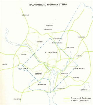
1962 Kennedy Administration plan
The B&O "Y" Route concept initially enjoyed significant political support, and an apparent lack of any broad opposition upon its suggestion by the Kennedy Administration in 1962
The Committee of 100 on the Federal City supported it, with the added provisions that it consist of a pair of 4 lane freeways feeding into an 8 lane freeway.

1963-64 study: routes considered
Yet the 1964 report deviated sharply from this concept, and would do much to poison local opinion towards building any NCF; it was not until 1966 when a supplementary study was released that closely followed the 1962 concept.

1966 supplementary study: B&O Low Level Route
Both these 1962 and 1966 plans included highway and what became WMATA rail.
By that time (1965-66), significant swaths of people within the Federal government changed their position by 180 degrees. This included the Committee of 100 on the Federal City, which went on record against a B&O Route North Central Freeway, based upon the negative reaction of the 1964 plan with its significant deviations from the railroad.
The 1966 plan lacked these objections, and at that time had the support of the D.C. City Council and the U.S. National Capital Planning Commission (NCPC). Yet the B&O Route North Central Freeway (and the East leg of the Inner Loop) was to be challenged by a law suit alleging that the planning for these highways was illegal for lacking DC City Council and USNCPC approval, prior to that being the case! The suit was filed when both of these entities supported the plan.
It was not until 1968 that USNCPC withdrew their support for the North Central - Northeast Freeway, with their erroneous conclusion that the facility would merely add another arterial when in fact it would introduce a super-arterial in a broad area without one.
February 6, 1967: presentation of the new B&O Low Level North Central Freeway plan to NCPC
May 1967: NCPC approves 1st link of North Central Freeway
October 1967: NCPC approves final link of North Central Freeway 8-2
February 1968: law suit decision by U.S. Court of Appeals
February 17, 1970: D.C. City Council votes against North Central Freeway
September 17, 1970: legislation in Congress in the House Public Works Committee ordering North Central Freeway construction.
April 9, 1972: Maryland drops I-70S
February 1973: Maryland drops I-95 by the Northwest Branch Park corridor.
July 16, 1973: Maryland drops I-95 via the PEPCO right of way.
The justification given for this 180 degree turn has been given as avoiding the shifting of the burden from wealthier to poorer areas. According to the unfortunately error-ridden November 2000 article in The Washington Post Magazine it was because Takoma Park's Sam Abbott pulled a guilt trip on Peter Craig by telling him that he only cared about the wealthier people to Rock Creek Park's west
However, such is what occurred by doing just that.
Canceling the B&O route North Central Freeway would translate in one way or another to shift the traffic burden even more disproportionately along the east side of the Anacostia River through Washington, D.C.’s Ward 8, along D.C.’s Route 295 Kenilworth Avenue Freeway: which the Committee of 100 on the Federal City favored placing an even greater share of the burden with
a 1968 plan to route inside the Beltway I-95 via the Northwest Branch Park corridor, to route I-95 upon that same Kenilworth Avenue corridor, and then to a new bridge to Virginia to connect to the I-95 (today's I-395) Shirley Highway via a
Four Mile Run Expressway.
This blogger is unaware of any advocacy by the Committee of 100 towards mitigating this highway's local impacts by covering it as tunnel.
 Accordingly, people in Takoma Park opposed the North Central Freeway, even with the B&O railroad route as proposed in November 1962, because it would displace a row of houses.