 Rather then follow the recommendations of the 1962 report, for a "Y" route North Central Freeway along the B&O railroad, the
subsequent North Central Freeway study studied different route concepts with an upwards of 37 preliminary and alternative options, many which ran nowhere near the B&O railroad, or did so for only part of the route.
This was the first report to adopt the Fort Drive route for the D.C. portion of the I-95 Northeast Freeway, maintaining the earlier proposed Maryland routing via Northwest Branch park, but abandoning the 1960 routing through Catholic Sisters College properties.
Though adopting the "Y" route concept of the 1962 NCTC report, and recommending a route with a name including the word "railroad", the route veered significantly away this railroad in Takoma Park, Maryland and in Brookland D.C.

- 1 Sherman-8th Street-Railroad East-Sligo
- 2 Sherman-10th Street-8th Street-Railroad East-Sligo
- 3 Sherman-Elucid, 8th Street, Railroad-East, Sligo
- 4 Sherman, 8th Street, Ritchie, Sligo
- 5 Sherman, 8th Street, Woodside, Sligo
- 6 Sherman, 8th Street, Whittier, Railroad-East, Sligo
- 7 Sherman, New Hampshire, Railroad-East, Sligo
- 8 Sherman, 8th Street, Whittier, Ritchie, Sligo
- 9 Sherman, New Hampshire, Woodside, Sligo
- 10 Sherman, Euclid, Sholdiers Home, New Hampshire, Woodside, Sligo
- 11 Railroad East, Sligo
- 12 Railroad East, Woodside, Sligo
- 13 Railroad East, Woodside, Ritchie, Sligo
- 14 Railroad East, Woodside, Ritchie, Dale, Sligo
- 15 Railroad East, Woodside, Dale, Sligo
- 16 Sherman-Elucid-8th Street-Whittier, Woodside, Sligo
- 17 Sherman-Elucid-8th Street-Woodside-Sligo
- 18 Sherman-Elucid-Soldiers Home-New Hampshire-Woodside.

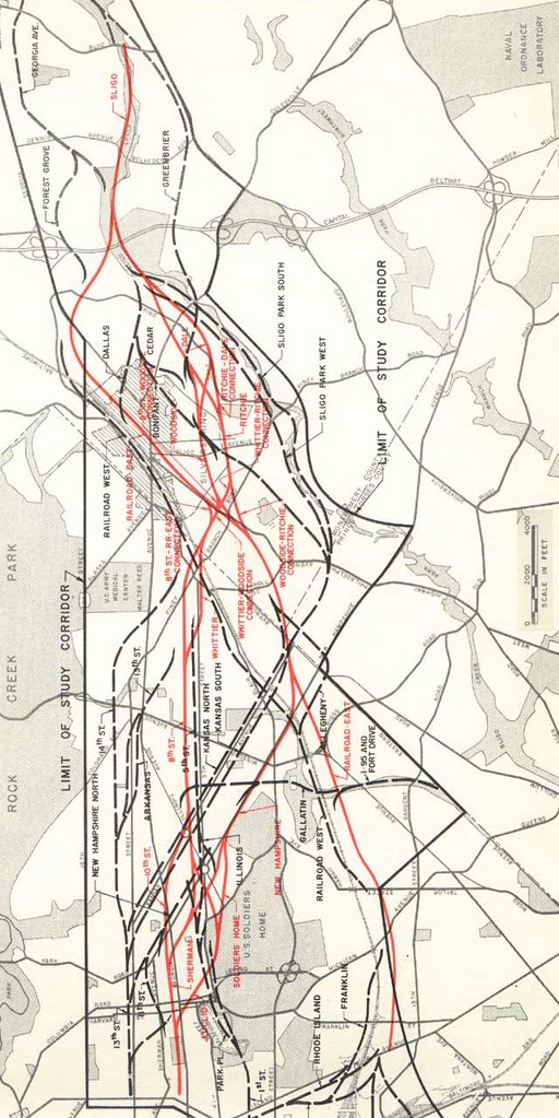
ROUTING CONCEPTS
The planning examined a variety of general routing schematics for these two highways, representing different combinations of the already recognized highway routing concepts of Georgia Avenue, and west Brookland, as well as the concepts of separate or shared alignments. In accordance with prior planning, routings roughly paralleling Georgia Avenue were studied for the I-70S North Central Freeway, along with western Brookland near the B&O railroad for I-95: whether as the Northeast Freeway upon its own alignment to the Inner Loop, or as the North Central Freeway as a consolidated "Y" routing.
I-70S North Central Freeway I-95 North East Freeway I-95 North Central Freeway
Option #11 "Railroad East- Sligo"This 1964 design study's adaptation of this basic concept would handle this confluence of the 10 lane I-70S NCF and 8 lane I-95 NEF with a number of lane drops:
(1) from 4 to 3 through the interchange for the general purpose roadways of the North Central Freeway, by diverting 1 lane to a ramp to the eastbound (clock-wise) Fort Drive Parkway and the I-95 Northeast Freeway northbound towards Maryland;
(2) from 4 to 2 for the I-95 Northeast Freeway to North Central Freeway to and from the south, by diverting the other 2 lanes per direction to and from a 1 lane connection to a tunnel connection to North Capital Street, and a 1 lane connection with the North Central Freeway to and from the north. This configuration would maintain the North Central Freeway's reversible 2 lane roadway, but not provide access between it and the I-95 Northeast Freeway, which then appeared in these plans without any such comparable reversible or otherwise separate priority traffic roadway. Route Corridors
In examining the general concept of a consolidated "Y" routing, the early 1960s North Central Freeway study considered different routing schemes for this "Y"'s lower portion: the I-95 North Central Freeway, either generally paralleling the B&O railroad, primarily in western Brookland immediately next to, or several blocks away from the B&O railroad, or roughly 1.75 miles west, generally paralleling Georgia Avenue like the 1959 Transportation Plan North Central Freeway. Both options had the I-95 Northeast Freeway enter the District of Columbia between Gallatin and Galloway Streets NE, where it would continue west via the Fort Circle Drive Park between these two roads for approximately 3/4 of a mile to intersect the B&O Metropolitan Branch railroad. Here, at Fort Totten, the option to continue I-95 via the railroad would turn to join the railroad's east side. This Fort Drive routing was a new feature of the 1964 North Central Freeway study that would avoid the disruption to neighborhoods and institutions of the 1960 I-95 North East Freeway routing by employing the existing corridor for the circumferential Fort Drive Parkway, while conforming with the Maryland planning for the Prince Georges County segment of I-95 to run via North West Branch Park, not covered by this 3 year study), while the option to continue I-95 due west along the axis of Gallatin, before turning southwesterly to meet a North Central Freeway route alongside New Hampshire Avenue or one further west running due south along 8th Street, both of which would have run to the south to join a route alongside Sherman Avenue NW. This study early on rejected the concept of a Georgia Avenue corridor I-95 North Central Freeway concept, in favor of the general B&O railroad corridor concept, with the former concept appearing only as a preliminary alignment that did not receive further consideration, and would not appear within any of the 17 alternative routes. Any new surface freeway in that area would require an all new swath and hence not only displace a greater number of buildings (primarily peoples' homes), but also introduce an all new bisection, in contrast to one along an existing bisection as that of a main line railroad. Yet, the reason this study would cite against the Georgia Avenue corridor I-95 concept, was what it termed the infeasibility of constructing a freeway with sufficient capacity to accept the combined I-70S and -95 traffic.
This study gave far more consideration to the concept of a Georgia Avenue corridor I-70S North Central Freeway routed separately from I-95, as they appeared in the 1959 Transportation Plan, with the I-95 Northeast Freeway on its own altogether separate right of way generally paralleling the B&O railroad. Of the 17 alternative routes, of which detailed drawings appear in this study's report dated October 1964, 12 provided for a separate I-70S North Central Freeway routing in the general vicinity of Sherman and Georgia Avenues, with 5 for a consolidated route in the vicinity of the B&O railroad and west Brookland. This study would conclude with a recommendation in favor of the consolidated "Y" route concept, combined with that of routing the North Central Freeway routing *generally* along the B&O railroad for almost all of its route in D.C. and inside the Capital Beltway in Maryland, running along the east side of the railroad tracks in Silver Spring (crossing Georgia Avenue as a high viaduct), before leaving the railroad corridor to run along east side of 16th Street, and ultimately to an interchange at Sligo Park with the I-495 Capital Beltway, where the reversible 2 lane roadway would start/end. Northward to its end at University Boulevard, the North Central Freeway would not carry an interstate highway number, and would have 6 lanes total (3 lanes per direction).I-95 NORTHEAST FREEWAY
All of the alignments examined for the D.C. I-95 Northeast Freeway by the 1963-64 study had it enter the District near Michigan Park, as did the I-95 Northeast Freeway route recommended in 1960. All of these were to have come from a Maryland route via Northwest Branch Park. However, the 1963-64 study would depart from the 1960 route, entering D.C. several hundred feet further north, and abandoning the 1960 plan's south-westerly routing in favor of running due was via the existing land corridor between Galloway and Gallatin Streets NE, reserved during the 1930s and 1940s for the Fort Drive circumferential intermediate parkway first proposed during the 1930s that was to link the sites of a number of historic parks within the District and northern Virginia. This adaptation of the Fort Drive route in response to criticisms by neighborhood residents, particularly the representatives of the institutions that would have had portions of their properties taken for the 1960 routing, from Catholic Sisters. This Fort Drive route between Gallatin and Galloway Streets NE would run from the Maryland line to the B&O railroad at Fort Totten. From here, this 1963-64 study considered 3 basic options:
(1) Preliminary: a I-95 Northeast Freeway extending west of the B&O railroad to meet a North Central Freeway parallel to Sherman Avenue on a shared alignment;
(2) Alternative: a I-95 Northeast Freeway that would turn south at Fort Totten upon its own alignment, and continuing as to roughly parallel the B&O railroad, with a North Central Freeway parallel to Sherman Avenue on separate alignment 1.75 miles to the west;
(3) Recommended: a I-95 Northeast Freeway that would meet the North Central Freeway roughly parallel to the B&O railroad, and so continuing southerly as the I-95 North Central Freeway.
I-70S NORTH CENTRAL FREEWAY
The range of routing options was far broader than for the Northeast Freeway, let alone the by 1962 canceled Northwest Freeway. While this 1961-64 study considered 1 basic alignment for the Northeast Freeway, with 6 routes so considered in 1960, and with 4 and 1 routes respectively studied for the Northwest Freeway in 1957 and 1959, this 1961-64 study studied 35 potential alignments for the North Central Freeway, including both preliminary study and alternative route selections, with or without a consolidation of the North Central and the Northeast upon a common alignment. Although route recommended by the study's report issued October 1964 report ran along the B&O railroad corridor for much of its length (with significant deviations in Takoma Park and Brookland, D.C.), all of the alternative routes and preliminary routes -- with the exception of a Railroad West route along the opposite side of the B&O railroad -- would have cut an all new swath directly through blocks and blocks of residential neighborhoods in D.C. east of Rock Creek Park, in Maryland in Takoma Park and Silver Spring, as well as along a stream valley- Sligo Creek Park.
I-70S/I-495 Capital Beltway interchange at Sligo Creek looking northwestI-95/I-70S interchange at Fort Totten looking to the southwest1964 air rights housing concept


 Interchange at the Beltway
 Along 16th Street to the east side of the B&O Railroad
 Along the B&O railroad in downtown Silver Spring, Maryland
 Veers about 1/2 mile away from the B&O railroad on new swath through old neighborhoods in Takoma Park, Maryland, taking 471 houses for the 1.1 mile segment, before rejoining the railroad immediately north of New Hampshire Avenue
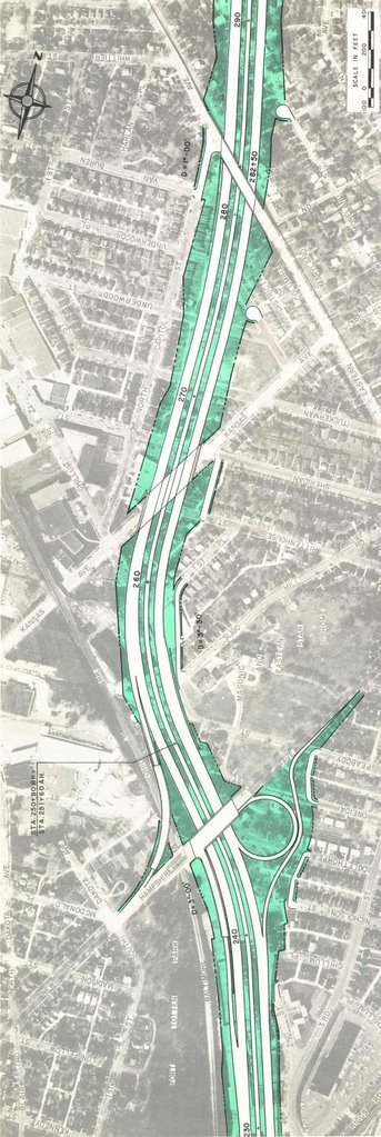 I-70S North Central Freeway re-joins B&O railroad by New Hampshire Avenue
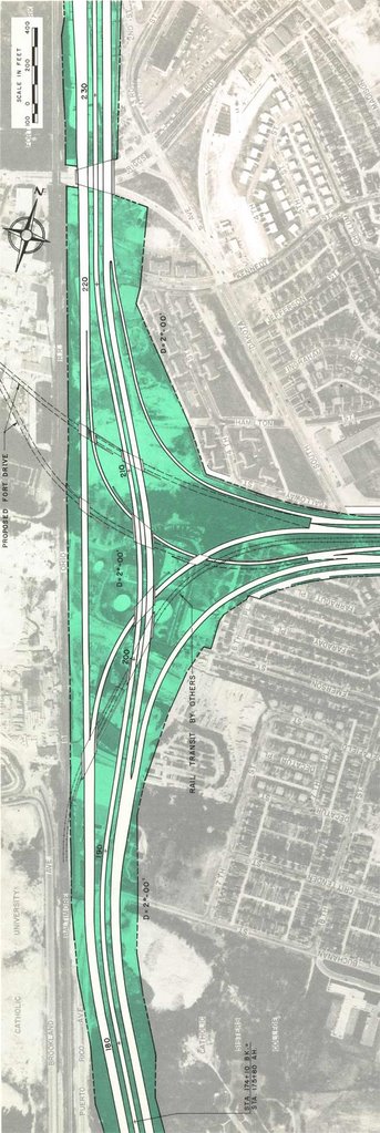 Interchange with I-95 Northeast Freeway via the Fort Drive route;
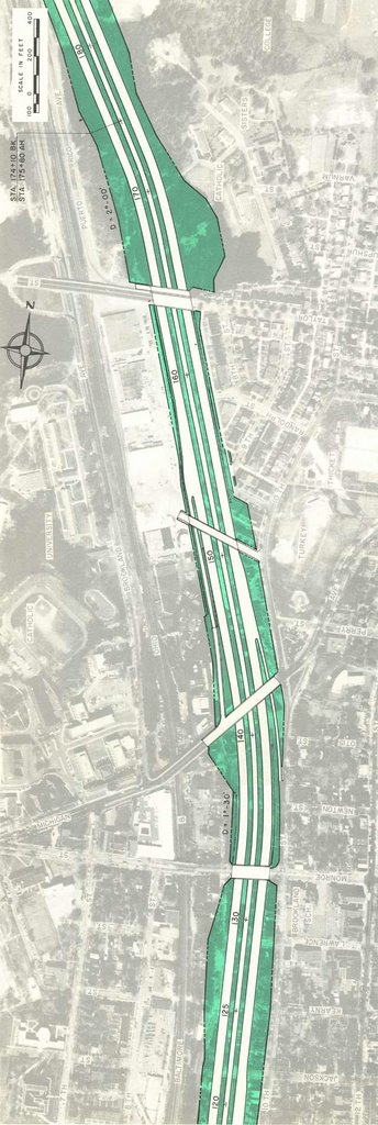 North Central Freeway at western Brookland by Catholic University of America
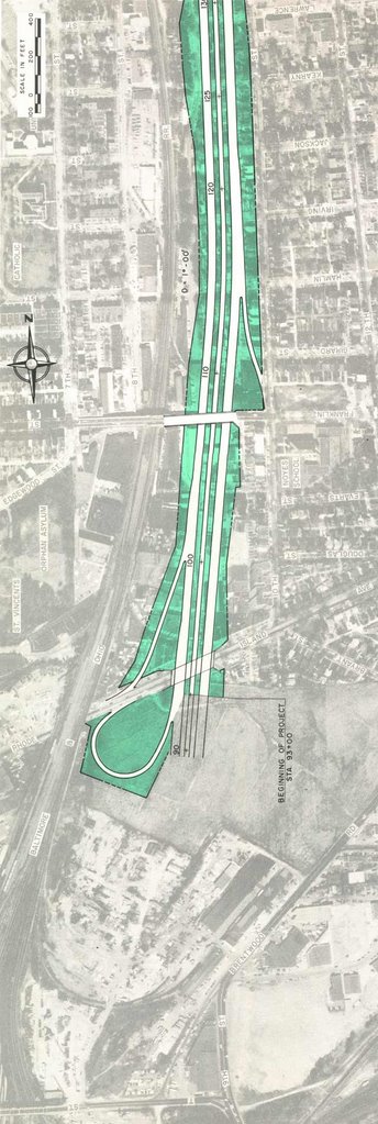 North Centra Freeway at Rhode Island Avenue
 Illustrations by Sam Abbott, cir December 1964
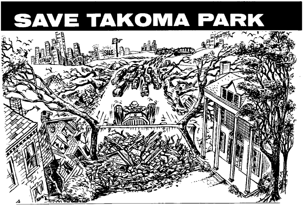
| Washington, D.C. portion | Route #1 Sherman-8th Street-Railroad East-Sligo Highest D.C. residential displacement | Route #4 Sherman, 8th Street, Ritchie, Sligo Highest Overall residential displacement | Route #5 Sherman, 8th Street, Woodside, Sligo Highest D.C. residential displacement | Route #9 Sherman, New Hampshire, Woodside, Sligo |
Route #11 Railroad East, Sligo The recommended route
| Route #12 Railroad East, Woodside, Sligo | Route #14 Railroad East, Woodside, Ritchie, Dale, Sligo | Route #15 Railroad East, Woodside, Dale, Sligo | |
| Length in miles | 2770350/440/430 | 4.5 | 4.5 | 4.0 | 3.5 | 3.5 | 3.5 | 3.5 | |
| ROW Costs | $62,156,000 | $62,156,000 | $62,156,000 | $51,652,000 | $46,314,000 | $46,314,000 | $46,314,000 | $46,314,000 | |
| Construction Costs | $60,046,000 | $59,951,000 | $60,065,000 | $51,146,000 | $28,739,000 | $28,739,000 | $28,739,000 | $28,739,000 | |
| Total in D.C. | $122,202,000 | $122,107,000 | $122,221,000 | $102,798,000 | $75,053,000 | $75,053,000 | $75,053,000 | $75,053,000 | |
| Maryland portion | |||||||||
| Length in miles | 4.5 | 4.3 | 4.2 | 5.0 | 5.3 | 5.0 | 5.1 | 5.1 | |
| ROW Costs | $19,159,000 | $17,123,000 | $15,613,000 | $21,076,000 | $24,345,000 | $21,076,000 | $22,437,000 | $20,973,000 | |
| Construction Costs | $25,106,000 | $23,871,000 | $24,203,000 | $30,654,000 | $28,806,000 | $30,654,000 | $32,501,000 | $33,695,000 | |
| Total in Maryland | $44,265,000 | $40,994,000 | $39,816,000 | $51,730,000 | $53,151,000 | $51,730,000 | $54,938,000 | $54,668,000 | |
| Full route Beltway to D.C. Inner Loop | |||||||||
| Length in miles | 9.0 | 8.8 | 8.7 | 9.0 | 8.8 | 8.5 | 8.6 | 8.6 | |
| ROW Costs | $81,315 | ||||||||
| Construction Costs | $85,152 | $83,822,000 | $85,268,000 | $81,800,000 | $57,545,000 | $59,393,000 | $61,240,000 | $62,434,000 | |
| Total | $166,467,000 | $163,101,000 | $166,037,000 | $154,528,000 | $128,204,000 | $126,783,000 | $129,991,000 | $129,721,000 | |
| Washington, D.C. portion | |||||||||
| Annual Loss in Tax Base Assessments | $20,060,000 | $20,060,000 | $20,060,000 | $15,828,000 | $12,736,000 | $12,736,000 | $12,736,000 | $12,736,000 | |
| Estimated Annual Tax Loss Revenue | $502,000 | $502,000 | $502,000 | $396,000 | $318,000 | $318,000 | $318,000 | $318,000 | |
| Number of families/residences displaced | 2770 | 2770 | 2770 | 2310 | 720 | 720 | 720 | 720 | |
| Number of Employees Affected | 630 | 630 | 620 | 800 | 2500 | 2500 | 2500 | 2500 | |
| Maryland portion | |||||||||
| Annual Loss in Tax Base Assessments | $6,197,000 | $4,732,000 | $4,542,000 | $6,624,000 | $8,126,000 | $6,624,000 | $7,232,000 | $7,232,000 | |
| Estimated Annual Tax Loss Revenue | $211,000 | $161,000 | $154,000 | $225,000 | $276,000 | $225,000 | $246,000 | $247,000 | |
| Number of families/residences displaced | 350 | 440 | 430 | 660 | 590 | 660 | 720 | 720 | |
| Number of Employees Affected | 180 | 100 | 110 | 430 | 420 | 430 | 350 | 390 | |
| Full route Beltway to D.C. Inner Loop | |||||||||
| Annual Loss in Tax Base Assessments | |||||||||
| Estimated Annual Tax Loss Revenue | $713,000 | $663,000 | $656,000 | $621,000 | $594,000 | $543,000 | $564,000 | $565,000 | |
| Number of families/residences displaced | 3120 | 3210 | 3200 | 2970 | 1310 | 1380 | 1440 | 1440 | |
|
|


No comments:
Post a Comment