 http://www.roadstothefuture.com/DC_Interstate_Fwy.html
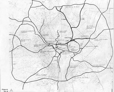
Sources: The design study, District of Columbia Interstate System, by DeLeuw, Cather Associates and Harry Wesse & Associates, LTD, 1971, prepared for the District of Columbia Department of Highways and Traffic, in cooperation with the U.S. Department of Transportation, Federal Highway Administration. This was the last official preliminary design for the D.C. Interstate system. I-595 source: Design Public Hearing brochure, October 25, 1984, Virginia Department of Transportation. WMATA Metrorail openings: history link on WMATA website.
Douglas A. Willinger has a vast amount of well-referenced, documented and accurate information about the Washington, D.C. Interstate and Freeway system on his Takoma Park Highway Design Studio website. I have read and studied enough about the system over the last 30 years, to know that his website is very accurate and very comprehensive. The address is www.highwaysandcommunities.com.
The illustrations above show I-95 via the Fort Drive-Northwest Branch route, instead of the subsequently adopted PEPCO route.
Note the B&O route's mid relative mid point spacing to the north south segment of the Capital Beltway in Maryland and the Canal Road Parkway corridor in NW D.C.
This would clearly be a most useful route for a new major highway link, though would also require improvements to the 3rd Street Tunnel and its connections with the South West Freeway- all things that the authorities pay precious little attention to...
It would also require improved design for the B&O, New Hampshire Avenue and PEPCO corridors... for both operation ability and for those alongside, with the generous use of cut and cover tunneling... with adequate setbacks preserved from overly close real estate development.
See:
1971 Deleuw
1971 D.C. B&O I-95 Brookland/CUA (Catholic University of America)
1971 D.C. B&O I-70S (I-270) Takoma


No comments:
Post a Comment