 1971 design I-70S North Central Freeway at Takoma, D.C.
 I-95 Northeast Freeway
The 1971 design proposal would adopt the "Fort Drive" routing, entering D.C. and running between Gallatin and Galloway Streets NE from a Maryland route via Northwest Branch Park. It differed from the 1966 plan primarily in adopting decking over -- essentially making cut and cover tunnel segments -- for portions within the subsequently renamed Fort Circle Park, with recreation facilities atop. Like the 1966 plan, it featured a rail transit line in its median, later built as the WMATA Metro Rail Green Line, as well as provide for a future tunneled connection to North Capital Street.
Though adopting the "Fort Drive" routing because of its long-standing, the 1971 DeLeuw/Weese study would discuss the variety of I-95 Northeast Freeway routes considered- previously and contemporaneously.
It would recommend in favor of the PEPCO Route for the I-95 Northeast Freeway in Maryland, with a set of dashed line indicating the location of its below ground level extension immediately north-parallel of New Hampshire Avenue for the 1600 segment beyond the PEPCO right of way to the D.C. line, and then within the District for another 1600 feet to meet the B&O railroad corridor. Adopting the PEPCO/New Hampshire Avenue route would save the 100 acres of parklands and 110 residences of the Northwest Branch park routing, as well as the Fort Drive Park/Fort Circle Park acreage within D.C., hence taking 0 residences in Maryland, at the trade of of 13 strip commercial properties along New Hampshire Avenue in Maryland including two gasoline stations, a Popeye's Chicken franchise and a Trak Super Auto Parts Store, and 23 houses within D.C., primarily towards the southern portion of the 200 blocks of Rittenhouse Street and Eastern Avenue NE.
I-95 North Central Freeway
Both plans maintained similar designs for the I-70S North Central Freeway - I-95 North East Freeway interchange, with these 6 and 8 lane highways merging together near Ft. Totten (with I-95 transitioning from 8 to 6 lanes with an exit only right lane to a connection to North Capital Street) into a 10-12 lane I-95 North Central Freeway, the 12th lane being a merge lane ending in the vicinity of CUA and west Brookland, with 10 lanes continuing through the I-95 North Leg. Both low level plans maintained the same alignment through the western edge of Brookland, avoiding Turkey Thicket via a routing immediately along the B&O railroad's east side through industrial properties before entering today's Metro Rail CUA/Brookland station bus depots, sidewalks and parking areas, altogether avoiding Brooks Mansion (in contrast to the 1960 and 1964 plans). Both plans maintained the same basic alignment to the south, with the highway following the railroad less closely as the former continued more due south while the railroad began arcing to the south, south-west, despite the latter route's superior panoramic southbound vista not mentioned in any of these highway design studies.
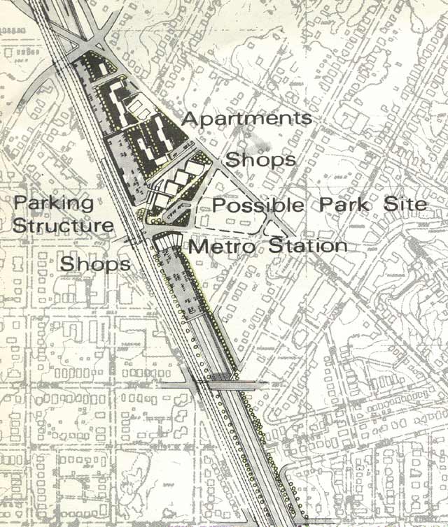
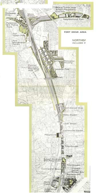
The 1971 design would adopt the Washington D.C. Department of Public Works 1970 alignment revision to reduce the number of homes required for removal from 69 to 34, along with the concept of decking over this portion of the highway, starting at a point about 400 feet north of Michigan Avenue, extending roughly 1/2 to the south, with its southern portal immediately south of Rhode Island Avenue. As so illustrated, the area would be devoted to community uses and Metro rail, with a parking lot with an adjacent supermarket proposed for the north side of Michigan Avenue, replacement townhouses built directly atop this "acoustically treated deck" as well as a one block long covering of the adjacent railroad for a proposed playground just north of Jackson Street.
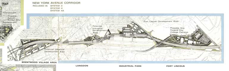
South of Rhode Island Avenue the I-95 North Central Freeway transitions to a depressed, and then to an elevated roadway, rising up to join the interchange "B" (as designated by this 1971 DeLeuw-Weese study) between the I-95 North Central Freeway, the I-95 North Leg, the I-295 East Leg, and the Route 50 New York Avenue Industrial Freeway, with I-95 turning from a southerly to a more south-westerly alignment with its transition from the North Central to the North Leg.
 The East Leg with tunnel segment under and along Mt. Ollivett Street. This would have taken some of the North Central Freeway traffic towards and past RFK Stadium as a bypass alternative route to the Center Leg.
 The I-66 K Street Tunnel with Center Leg and North Leg East at right.
 Center Leg with curved connection to North Leg East


No comments:
Post a Comment