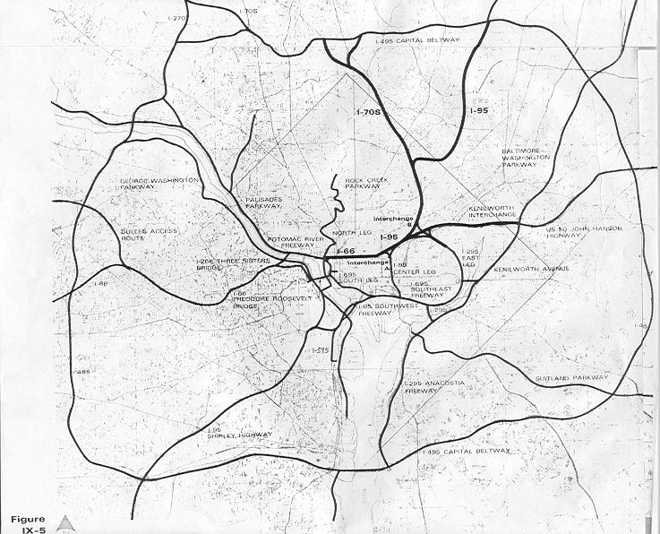
Construct a downtown underground Inner Loop with southern, eastern and northern spurs
Purpose
Provide for a more comprehensive transportation network within existing urban area
Serve security with additional evacuation routes.
Provide full downtown Inner Loop “hub” feed by radial spokes serving the southwest to northeast, southern, eastern, northern, and western compass coordinates.
Design Principles
Use existing corridors and rights of ways with minimal displacement
Use underground design.
Maximize the benefit- flexibility in design allowing future additions
Staged Construction phases to finish one component for use before addressing another corridor (IOW avoid simultaneously construction on two parallel corridors).
Be integrated with classical Washington, D.C. planning, extending the legacy of the L’Enfant and McMillan plans, with roadways beneath new landscaped promenades improving local pedestrian accessibility, such as along the Anacostia River and replacing the existing divisive surface and elevated railways now trisecting NE with the
Grand Arc Mall Tunnel.
Project would:
- replace the 14th Street Bridges.
- reconstruct the SW/SE Freeway underground from portal in vicinity of 14th Street SW, with c/d lanes for I-395 beneath G Street SW and 2nd and 3rd Streets SW/NW, extended to the northeast via tunnel with segment under O Street NW/NE to vicinity of railroad junction interchange
- construct the East Leg to RFK-East Capitol Street and then to the northwest as covered tunnel
- construct the I-66 K Street Tunnel with western and eastern approaches respectively beneath Pennsylvania and New York Avenues, with a Whitehurst Bypass Tunnel connecting to a Canal Road Parkway and a Three Sisters Tunnel to Virginia I-66.
- construct the proposed Kennedy Center lid with underground revisions that do not negatively impact operation ability
- construct a South Capitol Street tunnel connecting I-295 and I-395
- construct a New York Avenue NE tunnel along the railroad corridor, beneath a new landscaped lid alongside new development towards Maryland Route 50 via continuous freeway either via existing New York Avenue right of way as shown in recent DCDOT planning, or along the railroad.
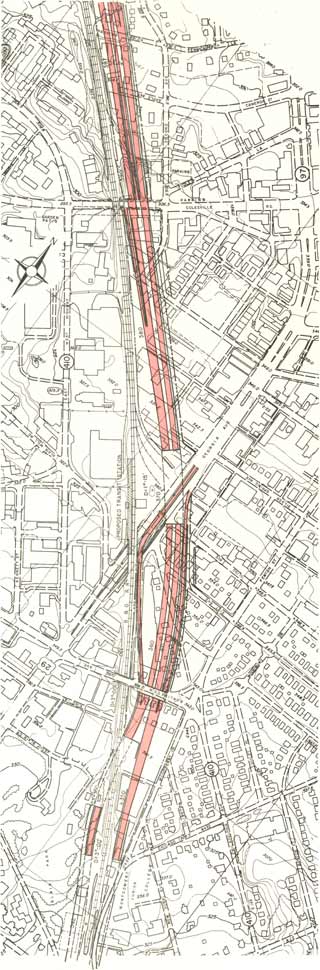
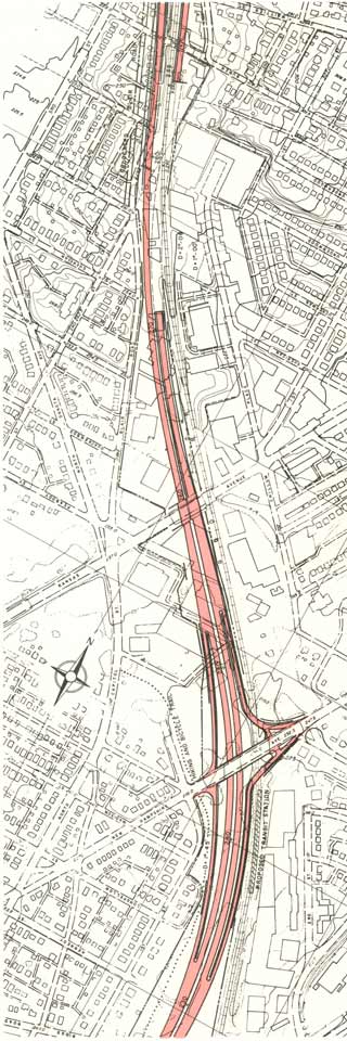
- construct a WMATA Red Line/B&O Metropolitan Branch multi-model transportation tunnel lowering the existing railroads with additional capacity, with a new underground highway from New York Avenue northwards with a split at New Hampshire Avenue for a PEPCO continuation in Maryland to I-95, with the railway/highway tunnel continuing north, northwesterly to the Capital Beltway, with downtown Silver Spring and Takoma heavy rail in a new bored tunnel, and with the Red Line partially in cut and cover tunnel and partially along existing surface segments, notably the historic art deco George Avenue overpass. This serves as the foundation of a new landscaped lid that would extend southwards towards and architecturally integrated with the back side of Union Station, and extending northerly through the Brookland/Catholic University of America and Takoma areas: the
Grand Arc Mall Tunnel.
Differences from earlier designs:
SW/SE Freeway fully depressed and buried, with c/d lanes for I-395 SW Freeway- Center Leg Tunnel and extension.
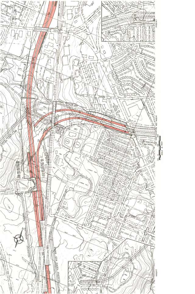
North Leg Re-Routed to minimize displacement of the vanguard of historic DC neighborhoods, while improving operationability, with routing shifting the eastern approach to the I-66 K Street directly under New York Avenue, as well as keeping I-66 and I-95/I-395 in separate tunnels until a point further east near the railroad junction. This latter tunnel (illustration below) would
arc northeasterly beneath the intersection of New Jersey Avenue and N Street NW and the recreation field of Dunbar H.S., transitioning to a two level configuration beneath O Street before turning to follow New York Avenue. This reduces displacement from the 1971 design by some 95%, from 148 and 600+ respectively for the I-66 and I-95/I-395 North Leg segments, to only 34, while providing the gentlest turning radii of any plan over the 1971 plan and the 1996 plan which displaces 0 but has the sharpest turning radii wrapping around the back side of the Bibleway Church complex. This would be far less disruptive to maintaining traffic flow during construction then the 1996 plan.

East Leg primarily covered as tunnelway with waterfront segment beneath new pedestrian terrace, and “orb” interchange at East Capitol Street, with design including c/d lanes.
North Leg West interchange placed underground beneath new landscaped terrace-staircase to Rock Creek Park.
I-66 West Leg Deck with highway grade lowered and new parallel western carriageway.
I-395 Red Line/B&O Metropolitan Branch multi-model transportation tunnel “B&O Route”,
Grand Arc Mall Tunnel, would place the railroad and the new highway beneath a new linear park that extends southward to Union Station, reducing the dwelling displacement in Brookland, D.C. from 34 (1970 revised plan) to about 14, with the southbound lanes in cut and cover along western side of railroad corridor, such as along the eastern side of 8th Street, with portal just south of Franklin Street.
This would afford perhaps the most spectacular view through the windshield anywhere along I-95 if not the entire U.S. interstate system.
I-395 New Hampshire Avenue via full tunnel beneath field of the Masonic Order of the Eastern Star Home to new traffic circle at D.C./Maryland line.
Preliminary Staging:
1 Establish I-395 bypass tunnel along SW Freeway and Center Leg easterly to Maryland 50:
Downtown Route: underground C/D carriageways for SW Freeway – Center Leg respectively beneath G Street SW and 2nd and 3rd Streets SW/NW, with extension to northeast to interchange NE, plus the New York Avenue East connection to Route 50, the South Capitol Street Tunnel, and the extension from the SE Freeway at the Barney Circle Underpasses/waterfront terrace to East Capital Street.
2 Establish an east west cross town bypass tunnel connecting the Whitehurst Freeway and I-66 with Maryland Route 50 and East Capitol Street:
Northern East-West Route (North Leg): Pennsylvania Avenue/K Street Tunnel/New York Avenue Tunnel and Mt Olivett Road Tunnel to East Capitol Street, with improvements of added westerly carriageway, with grade lowering beneath a version of the urban deck design promoted as part of the Kennedy Center Access Project, connecting to a widened Theodore Roosevelt Memorial Bridge.
Complete the Canal Road Parkway to vicinity of Foxhall Road.
Construct a Whitehurst Bypass Tunnel with a split to a Three Sisters Tunnel to I-66 in Virginia, and to the Canal Road Parkway. The area of the connections at the foot of Glover-Archibold Park and Georgetown University should be the object of a design competition.
3 Establish the SW/NE Gateways:
Reconstruct I-395 from Virginia upon new monumentally styled twin spans centered on the Louisiana Avenue axis going underground at a new traffic circle at 14th Street SW, with construction made easier with traffic diverted onto the already constructed new c/d carriageways
Construct the
Grand Arc Mall Tunnel with the New Hampshire Avenue Tunnel spur connecting to the Maryland PEPCO extension to I-95
4 Fix that suburban east-west link:
Reconstruct the I-495 Capital Beltway with additional capacity for the I-270 connections largely buried beneath land that becomes part of Rock Creek Park, starting with its new carriageway just south of the existing Beltway
An option would be to supplement this with a largely deep moled tunnel for a Wisconsin Avenue corridor link
Cost Guess: $25 billion over 15 years
Stage able design would allow some defer ability flexibility.
Cut and cover tunnel construction disruptions to traffic would be minimized via top down construction, that is, construct a new surface roadway first and then excavate and finish the tunnel beneath. This could bring the time of the surface disruption to about that established planning groups would tolerate for such streetscape projects as the K Street transitway.
Volvo's Subliminal Message for Takoma Park
Grand Arc Mall Tunnel
Answering A Critic
 Washington, D.C. I-395 options
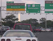
 Currently truncated I-395 Center Leg at New York Avenue


 Commuters in the nation's capital are drawing closer than ever to paying a congestion tax, thanks to lobbying from the Federal Highway Administration. The agency has created a "toolbox of potential measures" to improve congestion in the area that essentially boils down to a single proposal: toll booths on the 14th Street Bridge.


