A Trip Within The Beltway 102Realities’ Undercurrents:
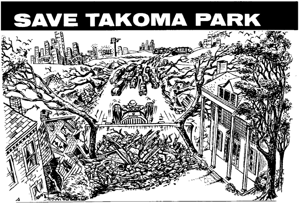
That’s some ‘white mans’ roads through black man’s homes'

I-95 'stumps'
Stump CityFailing to extend I-95 inside the beltway always seemed to me as representative of a bizarre clash between public functionality and secreted political interests- so truncated during the 1970s – with 1st interchange design’s stub roadways a clear testimony to the fact that I-95 was intended to continue – yet canceled mysteriously. Its cancellation was popularly attributed to simple opposition to ‘white mans’ roads through black mans’ homes’: a conceptualization disregarding the basic physical realities of that of the existing corridors, starting with that wide open power line corridor extending well inside the Beltway.
White Mens’ Roads through Black Mens’ Homes?
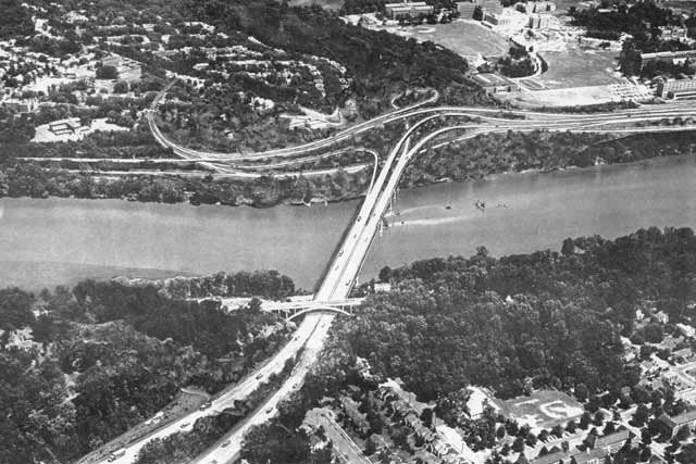
I first saw this in 1972 at the age of 91/2 on a family visit to Washington DC upon the then newly completed south of Baltimore 8 lane I-95. Crafted on a wide right of way with a generous grassy median that begins to run alongside the 250 foot wide electrical transmission (power line) corridor to its interchange with the I-495 Capital Beltway, I-95's pair of 4 lane roadways ended abruptly just inside the Beltway, where a temporary u turn took us to the southerly bound clockwise direction of that Beltway taking us to the Baltimore-Washington Parkway, which connects to Washington, D.C.’s defector eastern gateway- New York Avenue.
At our stop at the Howard Johnson’s Motel in Cheverly Maryland, where I asked a man working there what was up with the inside the Beltway extension of I-95, I received the answer that it was because the popular idea was it was "white mans’ roads through black mans’ homes” – an answer that left me perplexed. Though the term implied something requiring the clearing of many houses and other buildings, I-95 clearly had that existing PEPCO corridor continuing well inside the Beltway.
Riding in to downtown via the largely industrial New York Avenue corridor with its parallel railroad, and noting the extension of such to the north via the railroad extending northwards from Union Station, only made this justification of opposing ‘white mans’ roads through black mans’ homes ‘ of stopping I-95 at the Beltway even more mysterious – against a backdrop of coming from an area of Westchester New York where I-95 was constructed through the downtowns of towns as New Rochelle and Larchmont alongside the existing railroads: a logical routing choice to minimize local impacts.

Alongside U.S. Archives II

The 250 foot wide PEPCO electrical power transmission line corridor, which immediately parallels I-95 at the Capital Beltway and continues to 1,600 feet from the D.C. line at New Hampshire Avenue
Roads For Many People Through Very Few Homes Exploring this years later with a personal tour of the PEPCO power line – B&O Metropolitan Branch RR – route, made me even more interested. The power line corridor, with its 250 foot width, extended for over 3 miles inside the beltway- hence providing a clear right of way requiring only the realigning of the electrical transmission towers all the way to the vicinity of the intersection of New Hampshire Avenue and Ray Road, about 1600 feet from the Maryland-District of Columbia line- requiring no residential displacement within Maryland, and there only the 13 or so retail strip properties along New Hampshire Avenue’s southbound side (with the topography permitting air rights development).
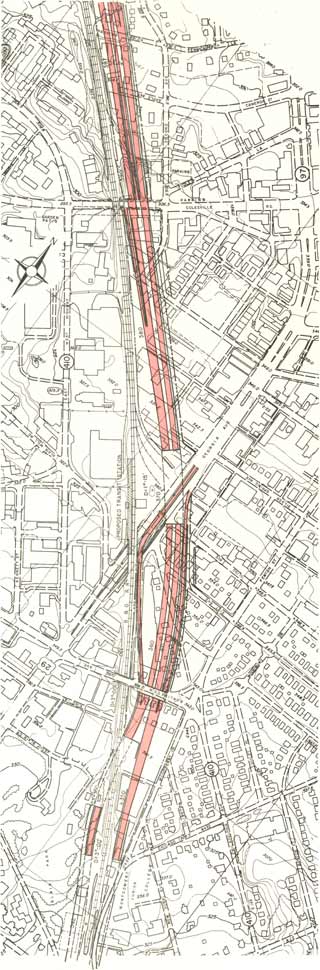
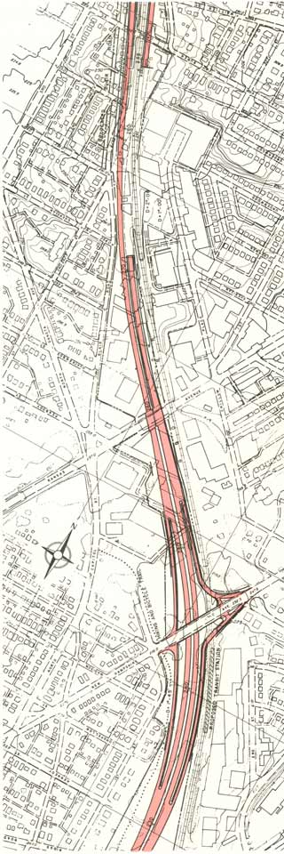
Once inside D.C., this route alongside New Hampshire Avenue encounters its first dwelling displacement – about 27 circ. 1940s red brick houses within the adjacent one block segments of Eastern Avenue and Rittenhouse Road – a number significantly lower then if routed along New Hampshire Avenue’s northbound side – owing to the large open field along New Hampshire Avenue’s southbound side with a single tree that is a part of the Masonic Home of the Order of the Eastern Star – before encountering about 5 more houses in this also approximately 1600 foot stretch from the MD-DC line to the Metropolitan Branch RR which is where the above ground fork of the WMATA Red Line runs.With its immediately parallel band of industrialized brownfieldesque properties and surface roadways, this RR allowing construction of Washington, D.C. I-95 with no residential displacement until the Brookland-CUA area just south of Monroe Avenue where the industrial band constricts, hence requiring some dwelling displacement for any new roadways along the RR’s eastern side. Notably this is the spot where the corridor “pinch” to the west, namely the building closest to the RR’s western side, a CUA dormitory was recently removed, hence providing a clear right of way that, if not transitioning somehow to the RR’s eastern side, would have to continue north of Monroe directly alongside CUA, respecting the existing building line, alongside and under Brookland Avenue, in what should be a cut and cover tunnel in order to contain traffic noise and pollutants within this more dense urban environment. Southward, I observed that such a west of the RR alignment not only provided the least displacement in the CUA-Brookland area, particularly with how this industrial – RR band widens westward towards 8th Street as it arcs to the south – but with the topography around Franklin Street where the land begins to drop significantly towards Rhode Island Avenue with a fairly wide but unused railroad corridor lined with decaying industrial properties continuing towards New York Avenue, where and which, as of 1991, a RR spur turned westerly to parallel that Avenue to 1st Street NE- taking it to a continuation of that axis which went through cleared properties to the east side of North Capitol Street, before continuing west through essentially the vanguard of residential Washington, D.C.- the cluster of Victorian townhouses between North Capitol Street and 4th Street NW -- for the connection to the Center Leg (initially designated as I-95 and today known as the I-395 3rd Street Tunnel.

http://dir.groups.yahoo.com/group/Brookland/?v=1&t=directory&ch=web&pub=groups&sec=dir&slk=11
Brookland, D.C. looking southerly over east side of B&O RR (at right),
with Red Line Station at lower right
next to Brooks Mansion that sits between 9th and 10th Streets NE


Looking towards the Franklin Street overpass along 8th Street NE along the RR's west side
This rail-side industrial property was NOT used by the recommended routes for the North Central Freeway, which instead placed it entirely to the railroad's east, through the western edge of Brookland, and hence away from Catholic University of America.
By 1966, the sole option considered that was routed via this space to the RR's west was a "Hi Level" elevated configuration- with earlier planning neglecting any discussion of employing this area as a cut and cover box tunnel, as would clearly be necessary in such close proximity to CUA
Sloganeering As Cover For Roads For More People’s Automobiles-Trucks Through Fewer and Fewer People’s HomesSo would studying the history.Whereas this southernmost segment west of North Capitol Street, as planned by 1971, would have displaced 600+ dwellings (with planning for their replacements via air rights development atop this highway segment as a cut and cover tunnel, the big cry over “white man’s roads through black mans homes” interestingly appears to be a far less concern then far fewer (and less architecturally significant) dwellings targeted by the B&O Route (Metropolitan Branch-WMATA Red Line) as planned by 1966, (69), reduced by a 1970 revision to only 34. I have seen plenty of historical indications of protests for these Brookland houses; but I have not found any regarding the far higher number in the area west of North Capitol Street for the final segment connecting to the existing Center Leg (3rd Street Tunnel). Though such a protest priority could have been seen as strategy of stopping the more destructive downtown segment by instead protesting the highway segment connecting to it to and from the north -- the B&O Route North Central Freeway – canceling that road failed to address that this downtown segment – the western portion of the North Leg East – was also planned to connect to a highway segment to and from the east, along the New York Avenue corridor with its broad RR-industrial belt towards the freeway in Maryland designated as Route 50, taking few if any dwellings. Hence canceling the B&O North Central Freeway would save 34 houses in western Brookland, yet a New York Avenue Industrial Freeway that itself might displace none, would nonetheless still require that final connection to the existing I-395 Center Leg/3rd Street Tunnel, yet the 600+ more architecturally interesting dwellings in west of North Capitol Street to 4th Street NW area were apparently less protested. Although this segment -- the North Leg East remained on some government planning books as late as 1980 or 1981 -- with the I-395 New Yor Avenue Industrial Freeway itself being 'de-mapped' during the late 1970s, the bulk of the organized protest apparently tapered off sharply after the B&O Route North Central-Northeast Freeway's effective political death with the July 1973 announcement of Maryland official's discontinuing planning for the PEPCO I-95 extension.
Forgotten in the “white mans’ roads through black mans’ homes logo-mania, was the reality that the Washington D.C. highway system as planned by 1971 would have taken a small faction then the systems proposed previously:
I-66 North Leg West: 148 primarily alongside New York Avenue just east of Mt Vernon Square.
I-95 North Leg East: 600+ alongside New York Avenue cut and cover tunnel segment between 4th Street and North Capitol Street,
plus alongside New York Avenue to 1st Street NE (since demolished) for transition to elevated segment crossing over Florida Avenue.
I-295 North Leg East: 172 alongside Mt Ollivette Road cut and cover tunnel segment with replacement dwellings); 0 further south to and past East Capitol Street to join the existing SE Freeway truncation at Barney Circle.
I-70S North Central Freeway: 150?
I-95 North Central Freeway: 34
I-95 Northeast Freeway in DC: 0 via Fort Drive Route; about 34 New Hampshire Avenue Route;
I-95 Northeast Freeway in MD: via NWB Park 110; via PEPCO route 110 (reduced by 1973 revised interchange design to 0)
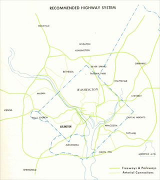
Earlier plans would have taken considerably more, such as the 1955 Inner Loop study report, and promoted by the D.C. Department of Public Works until about 1969: 10,000 for new swath cleared paralleling Florida Avenue and U Street for a primarily uncovered open trench 6-8 lane freeway before transitioning to an elevated I-95 North Leg East connecting to a new viaduct near Galludet University for the I-95 Northeast Freeway, as planned in 1960, through Brookland along 12th Street some 3 blocks west of the RR towards a Maryland continuation via Northwest Branch Park. That route alone would have displaced 1,100 dwellings within D.C. Meanwhile, routes paralleling Georgia Avenue for the North Central Freeway as proposed in the 1959 Mass Transportation Plan, and studied in the 1963-64 engineering study would have displaced an upwards of 2,700 dwellings within D.C. plus some 1,300 within Maryland.
This was true with much of those segments that were built:
SW Freeway took …; the SE Freeway …; the Center Leg …, the West Leg ….. and of course the Anacostia Freeway.
Taking into account the design revisions, stopping the un-built freeways meant stopping those that would have displaced the fewest and have provided the greatest functionality by completing continuous through routes with the least displacement, while preserving the discontinuity of the existing segments while doing absolutely nothing about their greater of displacement and diverseness.


1962 JFK Proposal
I-70S/I-95 North Central Freeway hugging the east side of the B&O Metropolitan Branch RR


1963 Abomination
37 options all over the map, none that strictly follow the RR
Sloganeering As Cover For Stopping Roads For More People’s Automobiles-Trucks Alongside and Through Powerful Entities’ Properties
The anti-freeway protests hardly correlated to absolute numbers of affected people, regarding neither different freeways or different freeway segments- IOW those areas suffering the largest numbers of displacement did not produce comparative levels of local opposition. For instance the 1957-59 Northwest Freeway along the Wisconsin Avenue corridor to a split to the south of Tenley Circle to an Archbold-Glover Parkway not allowing trucks and a ‘Cross Park Freeway’ to the east via Rock Creek Park’s fork along the northern edge of the Cleveland Park neighborhood via a pair of tunnels – bored for the Sidwell Friends School area, and cut and cover near and crossing beneath Connecticut Avenue towards a new high arch bridge over Rock Creek Park before landing upon an open depressed freeway configuration through the Mt Pleasant neighborhood before turning south to run some 500” west parallel to 14th Street SW. Most of the displacement was in the area to the east of Rock Creek Park. Nonetheless, the areas to the west where it would have displaced the fewest – 74 along the Wisconsin Avenue corridor from the Maryland line to the south of Tenley Circle split, and perhaps 6-15 along Cleveland Park produced most of the political opposition- while possessing a disproportionate amount of political influence as the nation’s capital’s wealthiest area. Rather, such protests reflected an array of variables including relative political affluence.
Significant segments of the Washington, D.C freeway system would built with relatively little protest, such as the Anacostia Freeway and the West Leg, SW-SE Freeway, and the Center Leg Freeways, respectively constructed in … and displacing ….. Yet it was the area of far upper NW along the Wisconsin Avenue corridor where the pressed highway would have displaced 74 houses (according to a 1957 engineering report) that was able to obtain in 1960 obtain a 5 year moratorium on any and all freeway planning to the west of Rock Creek Park- setting into a motion a continuing denying the need further and further east upon sentiments of class resentment, with the ironic effect of placing the traffic disproportionately in SE.
This was evident in the earliest stages of this with the early 1960s debates over whether inside the Beltway I-70S should run via the Northwest Freeway entering D.C. along Wisconsin Avenue, r via a North Central Freeway routed along Georgia Avenue- with that 2nd option having far higher housing displacement 2,500-4,100 in D.C. according to that highway’s initial engineering study in 1964- hence leading to the concept first officially proposed with the November 1962 White House Transportation Report under the JF Administration to replace the 3 separate freeways proposed in 1959 with a single 2 into 1 “Y” route situated to its west to the long established B&O Metropolitan Branch RR."The 1959 plan proposed three radial highways between downtown and Montgomery County and western Prince Georges County: one in Northwest, a second in North Central and a third in Northeast Washington. Considerable controversy has developed over all three routes but the Northwest hads generated by far the most opposition.
It is the Agency's view that the North Central and Northeast Freeways should be brought into the District and joined as a single route connecting with the recommended downtown freeway system and that the George Washington Memorial Parkway be built as planned. This highway system and high speed rapid transit service in Northwest, North Central and Northeast Washington will more then accommodate predicted traffic. Figures 15 illustrates this and an even more important fact- that at all points around the 10 mile square the recommended system will provide satisfactory highway service."
"Significance of Using B&O Route. Use of the Baltimore & Ohio Railroad corridor to bring Routes 70S and 95 into the city is the key to meeting the need for additional highway capacity in northern Washington, Montgomery County, and north-western Prince Georges County and at the same time avoiding the substantial relocation of persons, loss of taxable property and disruption of neighborhoods that would result from construction of the Northeast, North Central and Northwest Freeways proposed in the 1959 plan."
Why would the 1964 engineering report deviate so sharply from the 1962 JFK proposal- particularly when doing so would sharply inflame local anti-freeway sentiment?
Why would some officials fail to commit to the 1966 plan, instead favoring the 1964 plan, as late as 1968- particularly when doing so would sharply inflame local anti-freeway sentiment?
Why would ostensibly pro-highway organizations, such as the Federal City Council in 1966, favor building the North Central Freeway via the 1964 plan, as if a few months delays matter more then eternal changes- particularly when doing so would sharply inflame local anti-freeway sentiment? Why would each successive engineering study on the North Central Freeway introduce new design objections that were previously absent- particularly when doing so would sharply inflame local anti-freeway sentiment?
What is suggested by the apparent disinterest of Catholic University of America as well as the Masonic Order of the Eastern Star regarding the issue of covering the segments of I-95 that would have respectively passed alongside or through its properties? Note even today their apparent attitude regarding the issue of covering the existing B&O/Metropolitan Branch//WMATA Red Line in the CUA-Brookland area.


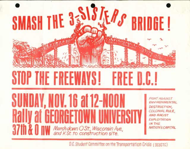
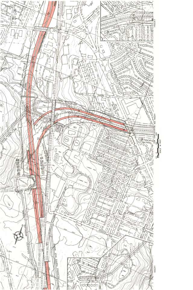
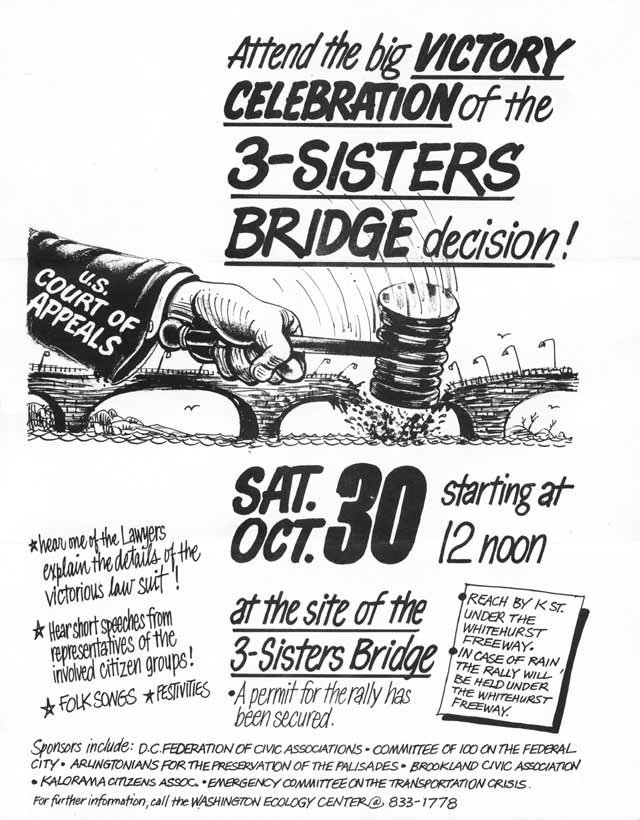
 The proposed I-266 'Three Sisters Bridge'
 1201 Pennsylvania Avenue