Tuesday, February 13, 2007

Alexandria Orb Page One News December 18, 2000


Six days after the Alexandria City council voted to trade away most of the proposed Washington Street Urban Deck, the Alexandria Orb with its far more generous lengthier urban deck made page one of The Alexandria Journal, and The Fairfax Journal on December 18, 2000.

Note the ironic juxtaposition with the article about “City negotiating with Feds for open space: Jones Point redesign prompts new talks”, (let alone “Schools turn to big brother: Surveillance Discussed”).

Strange how such negotiations never seemed to include any request to even study the Alexandria Orb design or concept, let alone restoring some of the lost proposed deck as proposed from 1994 to 2000.

This includes the subsequent time, post September 11, 2001, when anti-terrorist incidence planning eliminated the vehicular parking lots beneath the new spans, relocating them elsewhere in Jones Point Park. It seemed to me a logical time for a renewed request to adopt the Alexandria Orb, in late 2001-early 2002, just as construction preparations were underway for the thing that is now – as spring 2007, is almost complete.


What Happened At Alexandria City Hall

The Alexandria, Virginia Government Lies

The Route 1 Interchange/Washington Street Urban Deck Stakeholders Participation Panel overwhelmingly rejected the shorter deck, August 26, 2000.

Nonetheless, the Alexandria City government sold out with a proposal to “trade in” most of the funds for the urban deck for amenities elsewhere in Alexandria. This would trade away the environmental mitigation most needed by those nearest to the highway, to neighborhoods further away from the highway, with the policies contained within City Manager Phillip Sunderland’s October 20, 2000:

"RECEIPT OF REPORT ON THE WOODROW WILSON BRIDGE PROJECT PLANS FOR JONES POINT PARK AND THE URBAN DECK AND SETTING THE REPORT FOR PUBLIC HEARING ON SATURDAY, NOVEMBER 18 AND COUNCIL CONSIDERATION ON TUESDAY, DECEMBER 12."

It would state:

"There is general support for the concept of a shortened deck."

And at page 10:

"The Design Review Working Group supports whatever decision the City makes on the deck. The Urban Deck Stakeholder Panel, as a group, has not been presented with the plans for the smaller deck because they have not yet met."

Wrong. The Urban Deck Stakeholder panel met on August 26, 2000, and said no.

Nonetheless, at the subsequent events, the Alexandria City Council pretended otherwise.

With no public debate about the deck reduction, on December 12, 2000, they approved it unanimously.

That’s some government.

Comments November 2000 to Alexandria's City Council

THE CHOPPING OF THE PROMISED LAND
OF THE WOODROW WILSON BRIDGE PROJECT
WASHINGTON STREET URBAN DECK

The current moves to shorten or delete the long proposed Washington Street Urban Deck represents a betrayal of the communities nearest to the to be widened I-495 (and co-signed as I-95, in the wake of the mid 1970s cancellation of planning for a through DC I-95), which officials from the Wilson Bridge Project had long promised to Alexandria. Either proposal, the pair of 200 foot overpasses "Greetings" and "Streetscape", or the entirely deleted deck featured in the new animations of the I-495 approach to the new Woodrow Wilson Bridge shown at the November 9, 2000 VDOT Public Showing of the Route 1 interchange plans, represents the wrong direction for this Project.

Not only do they endorse the deletion of long promised new open green space for noise abatement for the communities with indisputably the greatest need for environmental mitigation, those nearest to the highway

AN ACCLAIMED HIGHWAY MITIGATION DESIGN FEATURE

The Urban Deck, otherwise known as a freeway lid or freeway lid, is a highly acclaimed highway design feature won by communities around the world in humanizing highways for communities as required in built up areas. The proposals to shorten or eliminate the urban deck fly in the face of overwhelming popular opinion, that if you are going to have to have that coveted piece of urban railway or highway, that it is preferably to have the thing buried. Communities work for getting these highway design features; nowhere do they push to have them deleted in favor of an exposed highway. None would call out for removing the roof of D.C.'s 3rd Street Tunnel, hence leaving an open trench I-395 crossing the National Mall. A 14 year controversy, between the initial 1971 proposal for a 14 lane open cut I-90 extension through Mercer Island, to a 1985 agreement for a 10 lane version with long cut and cover sectioned designed to ultimately preserve open green space in relatively crowded Mercer Island. Ultimate design not only one of form, but of functionality. As a major interstate highway, I-90 had to allow a wide variety of trucking, including HAZMATS. Therefore, the I-90 Mercer Island Tunnels would be designed and constructed with a state of the art ventilation and fire suppression system. Mobilized citizen concern made it politically impossible for highway planning authorities to shorten or delete the park-covered cut and cover tunnel sections, replacing them with uncovered, up-encased highway.

http://arts.endow.God/pub/Design95/pda/inter.htm
http://www.donnaonat.com/mercerisland.htm

Another such project is Charlestown, Massachusetts' Route 1 City Square/Tunnel.

http://www.bryant-engrs.com/projects/citysqr.html

There are currently popular movements to bury existing depressed open freeways, such as New Haven, Connecticut I-95, 350 foot and 500 foot decks proposed for improving water front access.

www.state.ct.us/dot/bureau/pp/docs/envir/nhh/nhhesview.htm

Cincinnati, Ohio, I-71 Fort Washington Way

www.fww2000.com
www.enquirer.com/editions/2000/02/01/loc_deal_revives_deck.html

I-405 in Portland, Oregon, for reclaiming 26 downtown blocks in what is currently vacant air space over the I-405 freeway.

The "Bridge the Divide and Cap I-405 Vision Study" details concepts of how to recapture some of the 38 blocks bulldozed in 1965 for the construction of the open cut 6 lane I-405 freeway. The result is projected to lead to: 1,000 housing units for 2,000 residents; 650,000 square feet of commercial space, generating 1800 permanent new jobs; 2,200 parking spaces; six acres of parks; two acres of indoor recreational uses and 50,000 square feet for civic/exhibition space.

www.aslaoregon.org/centennl/405.html
www.asla.org/centennial/OR_I405C.htm

www.oregonlive.com/todaysnews/9807/st070309.html

www.seattlep-i.com/neighbors/judkins/bg1.html

www.oregonlive.com/todaysnews/9810/st100619.html

www.ci.portland.or.us/mayor/press/I405rpt.htm

local.portland.citysearch.com/story/990405katz.html

Go to any of these places to see for yourselves, to hear the sounds of children playing and birds singing. Contrast this with a conventional open highway. The current proposal before the Alexandria City Council files in the face of developments elsewhere. It would be akin to proposing that the 3rd Street Tunnel be built not as a tunnel but as an open trench as it crosses the Mall (indeed, that would be one of the original 1955 proposals). Alexandria must not give up its promised and acclaimed mitigation for those living the closest to the highway.

MISREPRESENTING THE ISSUES OF NOISE: THE SHELL GAME OF "ORIGINAL" VERSUS WHAT IS PROPERLY THE "AMENDED" DECK DESIGN: SUNDERLAND REPORT PAGE 10,
ATTACHMENT 10

Proponents of denying the Alexandria communities their long promised mitigation for the oncoming Woodrow Wilson Bridge Project play a multiple bait and switch with their assertion that reducing or eliminating the urban deck would have "little or no effect upon noise" for Alexandria communities They do this with misleading the public about the noise issue by not comparing the decks they claim to set out to compare. They claim to compare their "Greetings" and "Streetscape" concepts with the "original" design:

In August, the community and City staff asked Potomac Crossing Consultants to calibrate the decibel levels associated with the Urban Deck. Originally proposed in the 1997 Final Environmental Impact Statement (FEIS) and the currently proposed concepts for a smaller Urban Deck. Attachment 10 contains the results of the study by the Woodrow Wilson Bridge Project Team, which analyzed noise levels through the year 2020 at various receptors and ambient points north and south of the bridge. The study concluded the following: "with the reduced length of the Washington Street Urban Deck, noise levels are predicted to increase 0-3 decibels on the north side of I-95, with the exception of Freedman's Cemetery that receives an increase of 10 decibels. On the south side of I-95, noise levels are predicted to increase from 0-5 decibels." Studies have shown that the human ear does not detect changes in noise levels which are three decibels or less.

Though the issue being presented - the difference between the "Greetings" and "Streetscape" rump decks and the "original" or 1997 design, the noise report (attachment 10) does not compare the "original" or the 1997 deck design, which was roughly 1,100 feet long, but rather the shortened 700 foot design that first appeared in the December 22, 1999 Draft Supplemental EIS. As this interim design differs from the "original" 1997 design with the deletion of 50% of its square footage to the east of Washington Street, it was the first design to completely remove the portion of the urban deck that was to extend alongside both the remaining two Hunting Towers, hence leaving the nearest tower, as well as about half of the southernmost tower completely exposed to a widened Beltway which would be about 20 feet away. By contrasting this late 1999 design with the two new proposals ("Greetings" and "Streetscape"), while essentially mislabeling the late 1999 design with the 1997 1,100 foot design with a chart of relative noise differences that clearly states it compares the new proposals with a 700 foot deck, proponents of virtually eliminating the urban deck understate the noise differences. Indeed, the planners are downplaying the noise issue, paying insufficient respect to the reality that noise travels up.

www.djc.com/special/design95/10002599.htm

Incidentally, the 1999 700 foot design was never presented before the SPP.

In those instances where the noise level exceeds 67 decibels, the Federal Highway Administration and the Virginia Department of Transportation will investigate whether areas exceeding 67 decibels are eligible for mitigation measures such as sound walls and determine the cost benefit ratios of the mitigation measures. The analysis consists of VDOT examining whether the noise mitigation measures will decrease the noise by a five decibel increment and whether an appropriate cost benefit ratio is achieved. Although this is the standard for review, there are times when these standards are not met, yet VDOT still has the discretion to employ mitigation measures in unusual circumstances (e.g. historic structures, hospitals). Decisions in general, on noise mitigation measures will be made using the above standard, as well as, validating public support for mitigation..

The area is a gateway to Alexandria, to Virginia and the Old Confederacy. It is the most built up area along the Beltway in Virginia or Maryland. It most certainly would be a candidate as an unusual circumstance worthy of justifying additional monetary costs.

A COMPLETE LACK OF IMAGINATION: POLLUTION CONTAINMENT

With respect to air quality, the Woodrow Wilson Bride (sic) Project Team has concluded that the air quality is not compromised by the reduced deck size

This is entire amount of words, and by extension thought, apparently given by the official planners with regard to vehicular air pollution. Representing an encasement of the segment of the I-495 Capital Beltway that passes through its most built up areas, the urban deck by its inherent nature would trap vehicular pollution, and preventing it from permeating the adjoining neighborhoods. The sole exception to this general rule would be possible concentrations at its east and west portals. However, the extent that this would be a problem, or even if it would be a problem at all, would relay to no small extent upon the ventilation system. A well-designed ventilation system would avoid this problem by collecting traffic pollution, and dispersing it, as done quietly with the I-90 tunnel-ways in East Seattle and Mercer Island.

An even better scenario would take this general technology further, by equipping a long Washington Street Urban deck with a ventilation system fitted with filtration equipment, perhaps employing electro-static technology. Such systems, which exploit his intrinsic environmental advantage of encased bellow ground road tunnel ways, are increasingly becoming the norm throughout the industrialized world, including Europe and Japan. Just recently in Australia, Sydney residents successfully persuaded their parliament to approve a bill mandating this equipment's installation in Sydney's current under construction cross-town highway tunnel project. Given this area's significance, this would be a very strong candidate for this more environmentally advanced highway design approach. There is no good reason why Virginia should lag behind the rest of the world.

THE CONVOLUTED LOGIC BEHIND THE CHOPPED DECK "GREETINGS" and "STREETSCAPE" PROPONENTS

The reasoning behind the proposals to chop the deck presented in the Sunderland report is convoluted and illogical for denying the deck for reasons that would also deny their proposals, to a near equal or even greater degree.

It states that the deck would have to be raised to accommodate ventilation equipment (exhaust fans, presumable ceiling mounted), hence relegating the Parkway to be somewhat depressed as it crossed the deck), and thereby leading to the October 20, 2000 City Manager Sunderland report's conclusion: we, therefore, do not recommend the larger deck. This conclusion is then buttressed by the observation that "while a positive idea in concept, later engineering analysis indicated that the proposed topography would require the walls supporting the deck to be very tall, creating an additional barrier. Ironically then, these statements are followed with the "Greetings" and "Streetscape", both of which flank the portion of Washington Street that crosses the Beltway with a raised berm that also results in Washington Street being depressed relative to the raised deck surface, and both of which would be accompanied by high vertical sound walls. While eliminating the deck would eliminate its 24 foot increase to the project's vertical profile, this would be replaced with vertical sound walls at least 17 feet high, if not higher. Furthermore, while there would be only a 6-10 difference in the vertical profile (such as where viewed against the backdrop of the 8 story high Hunting Towers), the chopped deck proposals would likely require sound walls where NONE are required for a longer deck, such as the Church Street area, including Freedman's Cemetery

It sanctions the decisions to eliminate open green deck space based upon leaps of logic, e.g. a previously proposed recreation field on the deck is somehow re-judged to be unfeasible or impossible, hence that portion of the deck gets deleted, without any regard to using that deckage for passive recreational uses. Proponents of chopping the deck disregard that this place is a Gateway, into Alexandria, into Virginia, and hence the U.S. South, disregarding the potential here not only for adequate noise abatement for a pedestrian promenade with a view of Jones Point Park, the Potomac River, as now being envisioned for New York City's West Side Miller Highway along Manhattan island's western shore between 72nd and 47th Streets, complete with a design with a covered tunnel-way that rises up, with its cover extending a 4-6 degree grade to meet its northern portal, as would a Washington Street Urban Deck.

www.pb4d.com/projects/highways/miller/maerials/maerials.htm
www.pb4d.com/projects/highways/miller/maerials/13f-opa.jpg

It sanctions entire questionable chains of decisions that, even if a questioning of an earlier decision would call a string of later decisions into question.

The portion of the deck to the west of Washington Street gets deleted because of an objection to a proposed soccer field's northern goalpost being too close to Freedman's Cemetery. Yet this happens because the field is turned to a north-south axis from its previously proposed east-west axis- this occurring because of the mysterious early 1999 decision to delete the canted western edge of the deck, so deleting 44,000 square feet of deck near the Church Street exist. No explanation for this is given.

Proponents of the chopped deck proposals utterly ignore the benefits of underground construction to adjacent property values and by extension property taxes. It would seem that chopped deck proponents are ignorant of the vast drop in property vales in Manhattan at 96th Street where the railroads transition from tunnel to berm, with property values being higher where the road is buried.

PHILLIP SUNDERLAND REPORT OF October 20, 2000 REPORT MISREPRESENTS THE STAKEHOLDERS PARTICIPANTS PANEL (SPP):
THEY ACTUALLY REJECTED THE CURRENT PROPOSALS AND THE CONCEPT OF CHOPPING THE DECK AT MEETING ON AUGUST 26, 2000

It disregards, indeed, states outright misstatements of fact with regards to the SPP (Stakeholder's Participants Panel), stating (at p.10) that the "Urban Deck Stakeholder Panel, as a group, has not been presented with the plans for the smaller deck because they have not met. This is an absolutely misleading, if not outright false statement: The Route 1/Urban Deck SPP met on August 26, 2000, where Wilson Bridge Project officials presented both the "Greetings" and "Streetscape" proposals to the SPP, which, after hearing the comments of the public, overwhelmingly rejected the concept of shortening the deck. Indeed, it should be noted that the Wilson Bridge Project [www.wilsonbridge.com] site's SPP chronicles [as of this writing], without any claims to the contrary, simply omits this piece of information about the August 26, 2000 SPP meeting's findings.

REMEMBER, THIS IS ALEXANDRIA"S MILLENNIA GATEWAY:

With attention focused upon the bridge itself, insufficient thought has been given to the approaches, indeed, there has been no design competition at all for the approaches.

The view that a shortened deck would somehow better represent the historical context of Alexandria as reflected by the various Alexandria commissions is preposterous. Are we to suppose that an open 12 lane freeway more represents the area's history than open green space?

Therefore, I implore the Alexandria City Council to reject the proposals for a shorter deck that further exposes Hunting Towers to more noise, including both the "Greetings" and "Streetscape" proposals, as well as the 700 foot design unveiled in 1999, which was never itself presented to the SPP separately.

Indeed, the Urban Deck MUST at least be extended to its original length or greater; it should DEFINITELY be extended fully east of Hunting Towers as per the original consideration of 1994-95, some 100 feet or so east of the traditional design exclusively shown from 1995 or 1996 to 1999. The issue of profile, is a red herring given the likely presence of high vertical sound walls without the deck, that this profile would be viewed against the backdrop of Hunting Towers, as well as the undeniable need for sound abatement for Hunting Towers. As per the Miller Highway proposal in New York City, this would make an excellent viewing promenade, regardless of assertions that fail to recognize this, as those presented to the public at the September 6, 2000 meeting.

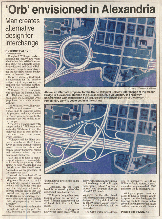
Instead, I implore the Alexandria City Council to pursue Alexandria's traditional yet dormant planning for monumental gateway traffic circles at its northern and southern Alexandria in this instance by working for a rejection of the existing design plans for the I-495/Route 1 interchange, a design more appropriate for Springfield than Old Town,
and hence, work for the adaptation of the Alexandria Orb design.

Thank You,

Douglas A. Willinger
Takoma Park Highway Design Studio

Comments September 29, 2000

LATEST WILSON BRIDGE PROJECT PROPOSAL TO VIRTUALLY ELIMINATE KEY MITIGATION FEATURE A BETRAYAL TO COMMUNITIES

The latest proposal to virtually eliminate the proposed Washington Street Urban Deck, by substituting a 200 foot wide Washington Street Overpass - via a choice between a "Streetscape" and "Greetings" design -- that eliminates the area of highway deck over the I-495 Capital Beltway approach in the area of Hunting Terrace and the western portion of Hunting Towers, would significantly INCREASE this project's environmental impact, and is the wrong direction for the Woodrow Wilson Bridge Project to take.

It would ELIMINATE the park-covering of I-495 alongside Hunting Terrace and Hunting Towers where it is most critically needed for removing noise and pollution abatement where a 12 lane highway and 8 story high apartment tower would sit only 25 feet apart, and where noise would travel up. On a basis of square footage of land either landscaped or paved, this proposal represents the greatest increase in this project's environmental impact, even greater than the difference between the official 12 lane crossing proposal and the alternative 10 lane bridge proposal, since it would replace parkland with highway where this would represent a total loss of parkland to highway use, in contrast to an area beneath a bridge which may still be used for alternative purposes. Indeed, viewed from the perspective of the number of highway lanes, deleting the highway cover represents a difference of 10, 12 or more lanes of traffic for the affected portion of the highway. In summary, this proposal would:

- REDUCE OPEN GREEN SPACE

- INCREASE HIGHWAY TRAFFIC NOISE AND POLLUTION

- REDUCE PROPERTY VALUES: TURN HUNTING TOWERS INTO A SLUM

- OFFER WAY LESS THAN WHAT ALEXANDRIA WAS PROMISED THROUGH THE PROJECT SELECTION PHASE

- A POOR VALUE FOR ALEXANDRIA [denying mitigation to those communities closest to the highway for a cash trade in representing only the difference between the new proposal and a late 1999 700 foot version, rather than the traditional 1,100 foot design shown since the mid 1990s, and which remains the plans in effect at the time of this Project's Record of Decision.].

This proposal would trade away benefits for Alexandria, away from those with undeniably the greatest need: the neighborhoods directly adjacent and near to the project, for reduced benefit. It would do this for a reduced amount of benefits; those considering trading away the Washington Street Urban Deck's construction funds might want to ask why they would only receive the reduced funds for shorter deck introduced towards the end of the EIS statement, that would leave the nearest of the Hunting Towers without the deck's critically needed noise abatement benefits, after the agreement for a pair of 6 lane drawbridges was reached. The $44 million being offered to Alexandria for unspecified city-wide mitigation represents the cost of a shortened version appearing in the December1999 DSEIS, being only 700 feet in length, and not the traditional approximately 1,100 foot long, $66 million version as it has appeared in renderings at the Woodrow Wilson Bridge Design and Study Center during the past approximate half decade, This would not even be the only deletion in 1999, the first being the deletion of the deck's canted western edge that had extended westward via a canted western edge to Alfred Street, with the official planners apparently seizing upon the neighborhood group request to maintain the Church Street exit ramp in its existing location rather than moving it west as an event to bring about a reduction of the deck at its west end, loosing its canted western edge, replaced with a more strictly north-south western edge that no longer extended west to Alfred Street (rather than perhaps notching the deck, if clearance with the Church Street ramp was required). Accordingly, the neighborhood request to not relocate this ramp to the west to keep its traffic off of a one block stretch of Church Street would result in a portion of this area loosing its stretch of the deck, so replacing proposed green-space with the roar of a widened Beltway approach. Whereas the proposed design that was shown the longest - the approximately 1,100 foot version displayed since about 1995 - was what was shown during the selection process, there was an even earlier decision to shorted the deck on its east end, ending immediately east of the northern *wing* of the northern (and nearest to the highway at about 25 feet away) Hunting Tower, leaving only its eastern wing (some 80 feet from the highway) next to an exposed highway. The apparently original version (around 1994) had placed the eastern portal about 100 feet further east, immediately east of the nearest Hunting Tower (as illustrated by a set of markings upon a drawing of comparative approach profiles as viewed from the north at the Design and Study Center). Project officials have asserted this was done because that portion of the deck would have been 4-6% degrees, inappropriate for active recreation (such as a soccer field) and hence said to have no use, as well as for reducing the "wall" effect as viewed from neighborhoods two blocks away to the north.

Nevertheless, whereas such an eastern extension would add relatively little height to the bridge approach (given the likely use of 17 foot high sound walls), it is unclear if this decision to roll the deck to the west away from portions of Hunting Towers gave due consideration in apparently deciding that this 6 foot net reduction in a portion of the replacement bridge's approach concerning neighborhoods two blocks away to the north weighed heavier than the far more significant differences in the quality of life for Hunting Towers, located as closely as 25 feet from the widened bridge approach. Given the fact of the proximity and the height of Hunting Towers and that noise travels upwards, it is not clear (at least to me) if the decisions regarding the location of eastern portal relative to Hunting Towers were based upon an adequate environmental analysis. It is unclear if this cir. 1995 decision was accompanied by any sort of noise modeling.

In any event, the official highway planning contention that extending the deck eastward would "serve no purpose" for this portion of a highway that is effectively a gateway into Virginia, suggests a highway planning mentality somewhat behind the curve- placing short term matters as construction costs as weighing perhaps too heavily in relation to long term environmental impacts. Beyond the apparent scant regard to noise and pollution issues (particularly regarding Hunting Towers), the decisions tto shorten the deck at its eastern end flies in the face of the ongoing popularization of the idea of Millennial Gateways for entryways into important areas, disregarding the idea of a sloped promenade deck at the time this very concept is featured in the preferred design for a proposed under-grounding of New York City's elevated Miller Highway (otherwise known as the West Side Highway between 72end and 57th Streets), featuring a northern portal with the closest portions of the decking atop as a pedestrian promenade with a 5-6% slope, conducted by the firm coordinating the Wilson Bridge Project, Parsons-Brinckerhoff.

http://www.pb4d.com/projects/highways/miller/maerials/maerials.htm

http://www.pb4d.com/projects/highways/miller/maerials/13f-opa.jpg

http://www.pb4d.com/projects/highways/miller/maerials/13f-opa1.jpg

Several years ago, the Wilson Bridge Center had a number of impressive displays of park-covered highways elsewhere in the U.S., such as the cut and cover portion of Phoenix I-10 that created Margaret Hance Park, and the largely covered I-90 in East Seattle and Mercer Island- the East Seattle "Gateway to the Pacific" tunnel portal, to illustrate the benefits of the proposed Washington Street Urban Deck; yet in recent years, perhaps in a reaction to reduce the project's costs, have shortened the deck while no longer displaying the illustrations of the covered portions of I-10 and I-90. In any event, other matters might suggest that the project's decision making process has been somewhat overly-conservative, including the popularization of the idea of Millennial Gateways, please see

http://Themillenniumgate.org/frame.htm

suggest that the official highway planning contention that extending the deck eastward would "serve no purpose" for this portion of a highway that is effectively a gateway into Virginia somewhat behind the curve- placing short term matters as construction costs as weighing perhaps too heavily in relation to long term environmental impacts.

Indeed, it would appear that the project officials have quietly backed off from the more generous offer of mitigation during the selection process leading to the 12 lane drawbridge crossing selection; several years ago, the Wilson Bridge Center had a number of impressive displays of park-covered highways elsewhere in the U.S., such as the cut and cover portion of Phoenix I-10 that created Margerat Hance Park, and the largely covered I-90 in East Seattle and Mercer Island --- "Gateway to the Pacific" to illustrate the benefits of the proposed Washington Street Urban Deck; yet in recent years, perhaps in a reaction to reduce the project's costs, have shortened the deck while no longer displaying the illustrations of the covered portions of I-10 and I-90. This is a short sighted approach that will make future transportation projects more difficult.

These decisions to shorten the proposed Washington Street Urban Deck fly in the face of experiences that communities elsewhere have chosen to resolve highway issues, via burying portions of highways where most needed for maintaining or enhancing the urban fabric and improving the environment by providing new parklands while encasing and filtering noise and pollution, particularly in built up areas with dwellings nearby and above the highway, as is the case with Hunting Towers. One would probably not want to advocate removing any portion of the highway "lids" (as they are known in the western U.S.), thereby replacing the quiet landscaped green park space with the roar of 10-12 lanes of traffic. Nevertheless, some people in Alexandria favor this proposal (at least regarding the western portion) because this would eliminate a proposed soccer field officially envisioned for the portion of the deck west of Washington Street, along with others concerned about the City of Alexandria being responsible for the new parkland's maintenance. Indeed, noise concerns were cited as an intolerable aspect of soccer playing, with some asserting concern over the idea of a load ventilation system (including one member of the Urban Deck Stakeholder Committee representing the neighborhood adjacent to Freedman's Cemetary), hence, accordingly, the best approach to stopping the soccer field would be stopping the deck, failing to consider alternatives as a deck without a soccer field, the effects of shortening the deck upon property values, ignoring the effects of reduced property values along the open segments of I-495 in southern Alexandria, or a scenario of the new parkland coming under the jurisdiction and funding of the U.S. Park Service, as if leaving neighborhoods directly next to an open highway were preferable to a soccer field, as if the latter were noisier or smellier than the former. In response to hearing about the concerns of community impact, the Stakeholder's Committee would recommend against shortening the Washington Street Urban Deck, with the Alexandria City Council choosing to postpone a vote upon this proposal -- initially scheduled for September 26 - according to project officials until the completion of noise modeling studies regarding the effects of the different deck designs, comparing, at a minimum, the 700 foot and 200 foot decks.

At a time when other cities are planning on burying railways and highways, why should Alexandria be subjected to an outdated mentality of highway construction that blighting communities and paves over waterfront access? The deck should not be shortened, but rather *extended* in both directions, extending it fully east of Hunting Towers, and to the west to restore Alexandria's waterfront access to Hunting Creek, as accomplished by the Takoma Park Highway Design Studio Alexandria Orb proposal, on display at

http://www.highwaysandcommunities.com

This proposal would extend the benefits of the Washington Street Urban Deck concept, architecturally integrated with an all new alternative design for the Route 1 interchange, featuring circular oriented "Orb" roadways with significant benefits superior to the official FHWA design, regarding traffic operation ability issues as well as environmental issues. Superior traffic operation ability benefits of the Alexandria Orb interchange include gentler turning radii (with a radii of roughly 400 feet as opposed to 250 feet) with greater capacity, intuitive layout (for instance, heading north, a left turn takes you west), fully free flowing exit ramps without the stop light of the official FHWA design for the express ramps to and from the east, free flowing underground ramp for I-495 eastbound to westbound "u" turn to detouring from bridge delays WITHOUT existing upon Alexandria surface streets, along with its routing of the I-496 westbound express ramp traffic to a Route 1 underpass without access to Franklin Street, hence maintaining the existing number of I-495 lanes with this access. Superior environmental benefits of the Alexandria Orb include the creation of new parklands. reuniting access to Hunting Creek and extending west via the park space to be created within the "Orb."

As a largely underground structure, the Alexandria Orb would be somewhat costlier, yet with much of this structure so consolidated -- e.g. with its various ramp walls as one side of one ramp, and the other of another -- presents a greater benefit to cost ratio than could be expected with altogether separate structures, hence somewhat offsetting the added expense of underground construction. If it were to add $100 million to the project's cost, it would represent an approximately 5% rise, making it far cheaper than a full river tunnel (which in all proposals has been matched with the existing Route 1 interchange designs, whether the existing structure or the Wilson Bridge Project design.

The Alexandria Orb would certainly present a better benefit to cost ratio than previously proposals for construction a 10 lane bridge, or a 10 or 12 lane tunnel, while providing full shoulders and maximum flexibility for adding Metro rail at the lowest cost and without the need to demolish express or HOV ramps, or for that matter, taking out lanes, hence freeing this Metro link addition for the threat of a political push to perhaps preserve the HOV lanes.

Douglas A. Willinger
Takoma Park Highway Design Studio

http://www.highwaysandcommunities.com

Comments; June 23, 2000 Design Public Hearing

SUPPLEMENTAL COMMENTS
DESIGN PUBLIC HEARINGS JUNE 23, 2000

ALEXANDRIA ORB;
SUPERIOR ALL AROUND:

SUPERIOR AESTHETICS:

- Grand new gateway park space.
- No double flyer ramps across Cameron Run; no fly over ramps in northeast quadrant of interchange.

SUPERIOR TRAFFIC SERVICEABILITY:

- Greater/gentler turning radius for all ramps in contrast to FHWA design.
- I-495 "U-turn" capability to avoid bridge WITHOUT existing onto Alexandria surface streets.
- Free flowing ramps local and express/HOV ramps; NO traffic light in middle of interchange, in contrast to the existing, $450 million FHWA Route 1 interchange design.

SUPERIOR FLEXIBILITY:

- True rail accomodatability, without conflict with HOV lanes or express/HOV ramps in need of future demolition.

SUPERIOR BENEFIT TO COST RATIO TO OTHER PROPOSALS:

- "Buries" section of surface I-495 in strategic location to restore Alexandria, where highway isolates southern edge of Alexandria from waterfront at Hunting Creek, creating new green space for a TOTAL land recovery where the highway paves over the surface, rather than the basic Wilson Bridge replacement design, where a bridge would soar high up with far fewer support structures.

- Would effectively be a 0 lane I-495 along segment so encased, from west of Route 1 to just west of Royal Street.

- Would cost a fraction of a full river crossing tunnel with modern interchange.

- Creates a monumental Virginia Gateway, while re-uniting Alexandria with her water-front access to Hunting Creek that was lost to the Beltway by the time of the existing bridge's christianing/opening in December 1961.

- Would create a far, far greater public/social benefit:

- Creates several hundred thousand feet of usable open green space for public park use. Would create more open green space from land that is entirely paved over, then the difference in footprint through Jones Point Park between official 12 lane versus 10 lane CSB alternative.

SUPERIOR COMPATIBILITY:

- Is so designed for the official proposal for a pair of 6 lane spans, providing 12 vehicular traffic lanes via two separate roadways in each direction (without ramp conflict for the addition of rail via the shoulder space between the local and express roadways.

- Is adaptable to competing proposals for a 10-12 lane bridge or tunnel crossings in event that one of these is adapted in place of the pair of 6 lane spans.

- Furthermore, the Orb interchange is fully compatible with the concurrent or future addition of rail at the lowest possible cost, with or without deleting the HOV lane, nor requiring the demolition of millions of $$$ in HOV and/or express lane access ramps, either via the median or the shoulder space between the local and express roadways in each direction-thus still leaving each roadway with a full shoulder.

SUPERIOR ABILITY TO BE ADAPTED:

- Does not alter basic configuration of bridge spans, with any changes confined to its profile near Royal Street.

- Design changes limited to general area of the Route 1 interchange and bridge abutment: areas scheduled for demolition/construction AFTER the start of the construction of the southern of the two new spans in the Potomac River.

- Would not delay project if official planners promptly adopt it into the project's planning. The Alexandria Orb could be phased in to project planning without delay to start of bridge construction in middle of Potomac River, as this proposal effectively does not require changing any part of the bridge itself, beyond perhaps the area closest to the abutment at Royal Street, and which indeed, may be so plugged into any basic river crossing design scheme.

FLEXIBILITY OF FUNDING:

- Construction of the Alexandria Orb could be staggered in construction, building the basic interchange WITHOUT the ground covering within the interchange for the circular park, cutting millions of $$$ from its initial construction costs, substantially closing the gap between its costs versus the FHWA Route 1 interchange design, yet still allowing its eventual addition at some point in the future when funding may be more practical. This would be far less expensive than building and later demolishing the existing FHWA design to build the Orb from the ground up at some future date when Alexandria decides to reclaim its southern waterfront.

Douglas A. Willinger
Takoma Park Highway Design Studio

http://www.highwaysandcommunities.com

Comments; June 7, 2000 Jones Point Park

JONES POINT PARK COMMENTS

I) In the event of the adaptation of a full river tunnel crossing, as proposed by the Symonds Engineering Group and the Alexandria based All Tunnel Alliance, such a tunnel plan should be built with the Alexandria Orb interchange with several fewer ramps, with I-495 fully covered from the Orb eastwards. As shown in the Potomac Rossing Consultants, this portion of I-495 in the vicinity of Hunting Towers is apparently shown as an uncovered trench roadway. This treatment would replace the raised abutment area of a bridge with a deck that would slope downwards from Washington Street to Royal Street.

II) In the event of a bridge, whether the official configuration officially selected in September 1996, or a variant of the 10 lane bridge proposed by the Alexandria group Coalition for a Sensible Bridge, with or without a railway in the median that would drop below the I-495 roadways which would converge to thread the needle between the northernmost Hunting Tower and St. Mary's Cemetery, adopt some sort of modest cantilever to be built together with vertical sound walls along the sides of the bridge as it passes through Jones Point Park. The EIS already recommends vertical sound walls for this area which would be 17 feet in height.

A cantilever lip over the edges of the highway would have several intrinsic benefits:

a) noise retention

b) vehicular traffic emissions control

c) relatively low cost, given the inclusion of the above mentioned 17 foot high vertical sound walls. By there very nature, this cantilever could be added at a later date, as part of a general long range plan to provide a variety of transportation alternatives along the Wilson Bridge replacement. Yet, having these cantilever lip precast and integrated
with the vertical sound walls may well lower the ultimate construction costs.

d) relatively little change in the bridge's profile, given the inclusion of the 17 foot high vertical sound walls scheduled for this segment of I-495.

The additional potential benefits of a cantilever lip are the development of a system of bicycle/pedestrian pathways along/atop the edges of I-495; these would extend directly from the outer edges of the eastern portal of the covered area of the Washington Street Urban Deck, along either or both sides of I-495 eastwards to the edge of the Potomac River at the eastern edge of Jones Point Park, where they would end, where they would be connected by a brief deceiver of I-495, similar to as officially proposed on Rosalie Park, for a pedestrian platform providing a magnificent river's edge vista to both the north and the south right at this Virginia gateway. The fact that this is the gateway to Virginia, and that this project's final record of decision is being made at the start of a new millennium would conspire in favor of the extra costs.

This potential pathway system system could be used either to replace or supplement the officially proposed bicycle/pedestrian path that is already to be included in any bridge constructed here. Employing them as a replacement would result in a somewhat steeper grade for the abutment area than a path design from the Washington Street Urban Deck to the I-495 roadway elevation, making them more appropriate as a supplemental system that could be added at relatively low cost if cast integral with the sound walls, if not something added later.

In any instance, the bridge design should include the necessary structural strength along its outer edges to ultimately support this inclusion.

III) Bridge structure should be constructed with highest regard to noise. Additionally, the undersides should be attractively finished (as it apparently appears in the formal renderings on the official Wilson Bridge web site at ww.wilsonbridge.com The fact that the newer bridge will have far, fewer "piers" (indeed it will not have piers as this term usually suggests, but rather an attractive arch like design), makes possible a far nicer area under the bridge qualitatively, although quantitatively, more of Jones Point Park would be under the bridge.

Douglas A. Willinger
Takoma Park Highway Design Studio

http://highwaysandcommunities.com

Comments; February 25, 2000 DSEIS

WRITTEN COMMENTS FOR FORMAL SUBMISSION
DRAFT Supplemental Environmental Impact Statement [DSEIS]
Woodrow Wilson Bridge Replacement Project
February 25, 2000

Douglas A. Willinger
Takoma Park Highway Design Studio

Sumitted to John A. Gerner, P.E. Project Manager for formal submission
into the comments upon the WWB Project DRAFT SEIS

INTRODUCTION

The Woodrow Wilson Bridge Replacement Project presents the fantastic opportunity to display how highways can be best harmonized with the surrounding environment and adjoining communities, as well as being designed as multi-model transportation facilities. Additionally, the project merits praise for including the highway design concept with the best potential for both shielding neighborhoods from traffic noise and pollution and improving the quality of life for those living adjacent to this project, of covering some of the I-495 bridge approach roadway in southern Alexandria. Indeed, the 1996 Record of Decision would state:

"A deck would be constructed over the Beltway in the area of Washington Street in the City of Alexandria providing opportunities for community enhancements, improving redevelopment potential, and reconnecting portions of southern Alexandria on either side of the Beltway"

Essentially, this could make a relatively short section of the highway into a tunnel, with the surface re-dedicated to new open landscaped green space: a concept known in the western United States as a "Freeway Lid", and in the parlance of the Woodrow Wilson Bridge Replacement Project, an "Urban Deck." Such "lids" "caps" or "decks" have been a key component of highway projects around the U.S. These projects include, I-10 in Phoenix Arizona's I-10, Seattle, Washington's I-5 Freeway Park, Mercer Island, Washington I-90, Detroit, Michigan's I-696 Duluth, Minnesota's I-35, Charlestown, Massachusetts' Route 1 City Square/Tunnel, with this concept being considered for new projects, such as in Portland, Oregon, where community planners and activists are looking at long term plans to deck over a 26 block long section of I-405 - a 6 lane trench freeway built during the 1960s - with new parkland and other community resources. The proper application of this design concept in southern Alexandria could significantly mitigate the project where it has the greatest need for mitigation in built up and historically and environmentally sensitive southern Alexandria. An encasement of the I-495 approach roadway, particularly the area of Hunting Creek, Hunting Terrace, Hunting Towers, Yates Garden, and the sites of St. Mary's and Freedman's Cemetery, along with innovative, multi-purpose noise control mitigation through Jones Point Park, would be a cost effective means of making a tunnel out of that portion of the project with the greatest need for mitigation.

Unfortunately, this mitigation feature, along with others, that are crucial in harmonizing the Woodrow Wilson Bridge Replacement Project with its surrounding environment, is being seriously undermined by a series of questionable planning decisions -- before and since the September 1996 Record of Decision, regarding the design of the project's mitigation in southern Alexandria, as well as the compatibility of the official roadway layout with the concept of the concurrent or future addition of rail transit. Although the project is supposed to be designed with communities in mind, the current design evolution has underwent some decisions in need of serious review.

THE SHRINKING WASHINGTON STREET URBAN DECK

A) As it once appeared, the Washington Street Urban Deck extended to a point about 200 feet west of the edge of the bridge abutment, a point immediately east of the eastern edge of the nearest of the Hunting Apartment Towers.

B) By 1994, the deck had lost 100-150 feet at its eastern edge, as illustrated by the various lines delineating the location of the deck's eastern portal upon a profile drawing on display at a 1994 WWB Design and Study Center Open House meeting. Instead of extending just east of the nearest Hunting Tower, the deck now ended jut east of that tower's northern wing. This deletion of deck space, a reduction of 25,000+ square feet of potential park space, now left the entire eastern wing of the nearest of the Hunting Towers exposed to the Beltway, only about 80 feet away

C) In early mid 1999, the bridge design officials allowed an airing of the local community group request to maintain the Church Street exit ramp at its existing location. Traditionally, the WWB replacement project plans included a relocation of this off-ramp, approximately 200 feet to the west. Representatives from the Yates Garden neighborhood, including those who attended the Woodrow Wilson Bridge Design and Study Center "Stakeholders" Meeting on the Route 1 interchange and the Washington Street Urban Deck, viewed this off-ramp relocation as undesirable for subjecting a lengthier section of Church Street to the off-ramp traffic. The authorities gladly complied with this request. However, to the best of my personal knowledge, at no time was it explicitly explained to the participants that maintaining the Church Street exit ramp at its existing location could or would lead to a deletion of approximately 44,000 square feet at its western edge, where the canted western edge of the deck would be replaced by a straight or curved edge, that would no longer extend as far west as Alfred Street. See Draft SEIS Figure 14-13 Carbon Monoxide Modeling Locations Urban Deck West Exit Portal, and Figure 2-5 Washington Street Urban Deck Conceptual Mitigation Plan.

D) In December 1999, the bridge design official released the current DRAFT SUPPLEMENTAL EIS, a document with a number of things to say about the proposed Washington Street Urban Deck." According to the 1999 DRAFT SEIS document summary, the Washington Street Urban Deck, which was initially "included to maximum size possible", has since been "refined in size to address programatic and functional needs…[this]… refinement based on City of Alexandria, NPS, and SPP input.

"Refinement" so translated hear, means to reduce the amount of deck and potential landscaped green open space, even possibly to a greater degree then before, with an illustration of an even shorter deck that would leave Hunting Towers significantly less shielded! While some of the illustrations in this document shows the eastern portal of the urban deck as it has appeared since 1994, just east of the mid point of the nearest Hunting Tower, and with the western portal so relocated to delete another 10,000 feet of potential green park space in the vicinity of the Church Street off-ramp, (See Draft SEIS Figure 14-13 and 14-14 Carbon Monoxide Modeling Locations- Urban Deck West Exit Portal/East Exit Portal). However, other illustrations in this very same document show a Washington Street Urban Deck with a new deletion of 200 foot at its eastern end, relocating the eastern portal fully west of the nearest Hunting Tower, leaving that tower exposed to the highway approach as close as 10-20 feet away: a additional deletion of approximately 60,000 square feet of potential open green space by Hunting Towers! (See DRAFT SEIS Figure 2-5 "Washington Street Urban Deck Conceptual Mitigation Plan", and Figure A-1 "Preliminary Interchange Design Key Plan"). Both figures show a proposed Washington Street Urban Deck that ends closer to Washington Street then ever before, with its eastern exit portal fully west of what would be the nearest Hunting Tower, therefore leaving that tower exposed to a 10-12 lane I-495 approach!

"Potential" sound wall locations, according to DRAFT SEIS Figure-15 Current Design Alternative 4A Potential Noise Barrier Location, would be 10- 12 feet in height [DRAFT SEIS at 4-65] along both sides of I-495 from the Washington Street Urban Deck's eastern portal all the way through Jones Point Park to approximately 1,100 feet east of the Potomac shore line for the northern side of the bridge, and about 400 feet for the bridge's south side. "Final decisions on these [sound] barriers would be made in the context of each State's noise policy [DRAFT SEIS 4-66]. In other words, the DRAFT SEIS speaks of, but does not necessarily guarantee sound barriers.

ROADWAY CONFIGURATION COMPATIBILITY WITH EVENTUAL METRO RAIL ADDITION: THE OFFICIAL PLAN'S DESIGNED IN CONFLICT BETWEEN HOV AND RAIL TRANSIT

The official alternative, 4A, agreed upon in the September 1996 Record of Decision, provides for a bridge cross-section providing 12 lanes for vehicular traffic, arranged with two separate "local" and "express" carriage ways, each providing three vehicular traffic lanes, (each 12 feet wide), plus a set of left hand and right hand shoulders, and plus a 2 foot wide painted separation between the middle and left-most express lanes, the latter so designated as an HOV-transit lane, with a 2 foot wide barrier separation between the four carriage ways, plus a 12 foot wide bicycle-pedestrian path along one side of the bridge. As it appears in the 1996 Record of Decision, this 3/3/3/3 plus bicycle-pedestrian path Woodrow Wilson Bridge Replacement roadway would have been 244 feet across. As it appears in this 1999 DRAFT SEIS, this roadway width has been slightly reduced, to 234 feet, via a reduction in the width of the left hand local carriage way shoulder, matching the width of the 6 foot left hand express shoulders, and the elimination of the 2 foot wide painted barrier between the HOV lane and the adjacent express lane. This removes valuable space that could be employed towards the least expensive accommodation of Metro rail, that of shoulder space conversion via the now 6 foot wide left hand local lane shoulder and the still 10 foot wide right hand express lane shoulder, along with the 2 feet of the barrier separation.. This would still maintain 1 shoulder apiece for the local and express roadways; however the extra space would be desirable for allowing the maintenance of a right hand express roadway shoulder, to help minimize the need for express traffic to cross the HOV lane to reach the left express roadway shoulder.

A 10 lane alternative, considered in earlier Woodrow Wilson Bridge Environmental Impact Statements, and supported by a variety of citizens' groups, would provide 5 lanes (each 12 feet wide) in each direction with a single carriage way in each direction with left hand and right hand shoulders, thus eliminating 1 lane and 2 shoulders in each direction relative to the official alternative, 4A. This would provide a total width of 170 feet, which would allow the replacement structure to avoid conflict with the northernmost of the trio of Hunting Towers, placing said approach only approximately 15 feet away from the 3rd and 4th floors of that apartment tower.

A variation of this 10 vehicular lane option that would add 24 feet in median space width for the concurrent or future addition of rail transit, such as Metro would be too wide to slip between the limited space to the south of St. Mary's Cemetery and Hunting Towers, thus requiring at least the demolition of the northern-most wing of the northern-most tower, (along with the temporary evacuation of the rest of the Tower during this partial demolition and reconstruction).

A possible variation of the alternative concept of a 10 vehicular lane, plus 2 lanes of rail transit (plus the 12 foot bicycle pedestrian path) in the median would have this rail right of way drop below I-495 through Jones Point Park, thus allowing the I-495 roadways (each with 5 lanes plus shoulders) to converge atop the rail transit way in order to squeeze between St. Mary's Cemetery and Hunting Towers, with this railway continuing westward through the replacement bridge abutment, generally beneath the I-495 center line. Suggested to me at the February 10, 2000 WWB DRAFT EIS public hearing by Stewart Schwartz, it does not appear in any of the earlier WWB EIS.

Of all of the past alternatives, that of a split crossing - bridge and tunnel - offers the best potential, by offering the possibility of capacity and saving the northern Hunting Towers. However that option was abandoned for cost considerations.

Either the 4a alternative - so modified to delete the right hand express on ramp to allow a shoulder space conversion for rail transit between the local and express carriage ways - or a 10 lane alternative - so modified with extra median space would provide the space needed for ultimately adding a rail component.

Deleting the right hand express on ramp to allow shoulder space conversion would provide a far more meaningful - e.g. less politically vulnerable - way of providing the necessary space without conflict with vehicular lanes, with regard to the official alternative 4A, and the greatest capacity.

THE GROWING ROUTE 1 INTERCHANGE

The official design process has rendered forth one basic design for the I-495/U.S. Route 1 interchange, roughly 1200 feet west of Washington Street, which has been so displayed in the WWB Project's various publications. This interchange, which would occupy a large area in the vicinity of Route 1 at Cameron Run, has underwent some design revision during the latter 1990s, with the intent of improving traffic serviceability:

a) The ramps added around 1996, that twice cross over Cameron Run, which provide right hand on ramps to eastbound I-495, for both the local and express roadways, which could preclude shoulder space conversion for transit, (see below).

b) The ramp, added in 1999 and presented at that year's "Stakeholder" meetings for carrying traffic from Route 1 northbound to I-495 westbound, at an elevation of about 60 feet above sea level at the area of the interchange the closest to Alexandria residential communities. This was done in order to eliminate a planned left turn with traffic light that the initial design would have required for traffic from Route 1 northbound to I-495 westbound.

These revisions would improve traffic serviceability, but they would as well increase the interchange's local intrusiveness, particularly at the northern quadrant with the ramp for Route 1 northbound to I-495 westbound traffic, approximately 60 feet above sea level, near Alfred and Church Streets. Nothing in the formal design process indicates any consideration or pursuit of innovative design solutions for placing some of these roadways underground.

RECOMMENDATIONS:

I. PROVIDE A MORE MEANINGFUL AND COST EFFECTIVE MEANS FOR CONTEMPORARY OR FUTURE ADDITION OF RAIL TRANSIT. Other areas of the country have constructed urban freeways with dedicated right of way for future rail as inexpensively as possible in the future. The current arrangement under the Woodrow Wilson Bridge Replacement Project of a combined HOV-transit line places the different modes -- rubber wheeled HOV and steel wheel rail -- differs to this in pitting the two modes of transportation in a possible perpetual political conflict for the right of way:

a) RAMP CONFLICTS: The official design for the Route I interchange presents 3 ramps which would have to be demolished for future conversion of the HOV lanes to rail: the two left hand express lane ramps to and from I-495 to the east, and the Route 1 south to I-495 east ramp which is a part of the ramp structure that crosses Cameron Run twice. As these left hand access ramps -- the exit from I-495 westbound, and the entrance ramp from to I-495 eastbound -- are the only access ramps provided by the official Route I interchange design for the express lanes, the addition of rail transit in the median would preclude vehicular access for the express lanes, thus tending to require a greater traffic balance to the local lanes.

b) TRANSPORTATION MODE CONFLICTS: HOV lane conversion to rail would be just that- a surrender of one vehicular traffic lane in each direction. By its very nature, this would be politically compromised in the future by the likely demand to not surrender the lane. How likely is adding rail by converting the HOV lanes, when doing means relinquishing a set of vehicular lanes in a high demand corridor, the demolition of millions of dollars in HOV ramps, and the inability of the official Route 1 interchange design to provide access to and from east for I-495 express traffic? Other jurisdictions have planned their urban express way networks with right of way dedicated for the eventual addition of rail that is physically separate from the vehicular highway lanes in a fashion preserving their intended use for rail transit rather then extra vehicular lanes, while avoiding a potential future political fight to preserve the HOV lanes by simply not ever incorporating rail into this project.

A better alternative -- one not requiring future ramp demolition or the surrender of a vehicle lane in this high demand corridor -- one more politically practical and inexpensive would be future shoulder space conversion. The official alternative 4A could provide this in a way that would still maintain a set of continuous shoulders, by the conversion of the shoulder space between the local and express lanes. Under the 1997 plan, these shoulders at 8 feet for the left hand local shoulder, 10 feet for the right hand express shoulder, with the 2 feet thickness of the barrier between these local and express lanes would yield a right of way of 20 feet in each direction, usable for carrying
each direction of a future Metro rail. This would completely preserve the right hand local shoulders and the left and express lane shoulders, thus largely preserving their safety benefits.

The 1997 SEIS noted that the official plan -- Alternative 4A -- would provide 2 separate road ways in each direction, each with 3, 12 foot wide lanes, with 10 foot right hand shoulders for express and local road ways, respectively with 6 foot and 8 foot left hand shoulders. This also included a 2 foot wide painted separation between the HOV and its adjacent lane. Since 1997, the official planning process has led to a decision to reduce the width of the bridge and its approaches, in part by reducing the width of the left hand local roadway shoulders, as well as the above mentioned 2 foot painted separation along the right side of each HOV lane. This decision may need to be reviewed, so as to not preclude this relatively low cost right of way conversion that would reduce the cost of adding Metro rail, with or without maintaining a right hand express shoulder, whether now or at some later time, particularly in light of new and potential development along this corridor.

II. Truly emulate the better example set with other highways, such as Mercer Island, Washington I-90, to illustrate how highways may be better integrated into the surrounding area in areas with the greatest need for mitigation and enhancement. Please see:

http://arts.endow.gov/pub/Design95/pda/inter.htm
http://www.donnaonat.com/mercerisland.htm

Better employ the concept of the "Washington Street Urban Deck"; truly extend it to maximum extent possible within area with the greatest need for mitigation and enhancement, employing it as a multi-purpose mitigation feature. Extend Washington Street Urban Deck fully east of Hunting Towers, bringing its eastern portal to the edge of the bridge abutment immediately west of Royal Street, providing 360 X 300 square
feet of landscaped open green space more than the 1994-98 WSUD configuration, that would serve multiple purposes of mitigation and enhancement, therefore providing a superior benefit to cost ratio:

a) Critically needed noise abatement; due to their co-proximity and the nature of noise to travel upwards, encasing I-495 for the entire distance that it passes alongside Hunting Towers, extended to the edge of the bridge abutment just west of Royal Street is NECESSARY for proper and effective noise abatement., with the additional benefit of noise and visual abatement around St. Mary's Cemetery. Helps insure Hunting Towers' standing as a more livable community.

b) A viewing platform, Royal Landing Park: an approximately 740 foot long park extending from Washington Street to the edge of the bridge abutment just west of Royal Street. This would have an eventual slope of 5-6% at its eastern end, comparable to what is being proposed for a covered highway project in New York City, designed by the firm coordinating the WWB replacement project, Parsons, Brinckerhoff: the MILLER HIGHWAY PROJECT in New York City along Manhattan's upper west side from 72nd Street to 57th Street. The preferred alternative with sloped deck (1999 MILLER HIGHWAY DRAFT SEIS) may be seen at:

http://www.pb4d.com/projects/highways/miller/maerials/13f-opa.jpg
http://www.pb4d.com/projects/highways/miller/maerials/maerials.htm

c) A more livable transition to bicycling pedestrian paths that provides more cover atop I-495 along the bicycle path along the area of St. Mary's Cemetery and Hunting Towers.

d) Monumental Gateway, complete with poplar and evergreen trees

e) Again, apply this concept of multiple purpose mitigation through Jones Point Park, with duel bicycle pedestrian roadways built atop and cantilevered over the outer edges of the I-495 local shoulders. This would provide superior sound and pollution control, while providing bicycle pedestrian paths on the bridge's northern and southern sides of the bridge without increasing the bridge's overall width. These duel bicycle pedestrian paths would extend to the east to the edge of the Potomac River, where they would transition to a single pathway for the portion of the bridge that crosses the Potomac River, via a brief platform crossing atop I-495 at the edge of the river that would make an excellent place for pedestrians to take in the view along the Potomac, both to the north and to the south. As this area of the bridge through Jones Point Park is already tentatively scheduled to receive vertical sound walls, their use as the foundation of the cantilevered bicycle pedestrian paths atop the outer edges of I-495 through Jones Point Park would be cost effective for the multiple benefits for providing the multiple benefits of these paths, the noise and pollution containment, while not requiring extra bridge width.. Indeed, these cantilevered bicycle pedestrian paths could present the opportunity to reduce the bridge's with by 12 feet through Jones Point Park.s.

II.I AIM TO RECLAIM THE SOUTHERN WATERFRONT!

According to the DRAFT SEIS document, the proposed Washington Street Urban Deck has been "included to maximum size possible." Nonetheless, although communities elsewhere have gained immense local benefits via relatively short segments of covered/buried highway, judiciously applied to allow communities to reclaim waterfront access, apparently no consideration has been given in this regard to extending this highway covering further west, so as allowing Alexandria to reclaim her southern waterfront. Apparently no serious pursuit has been given to a deck extension further west then the "canted" edge of the pre 1999 design, from the Hunting Terrace parking lot, north-westerly to the axis of Alfred Street, some one block east of U.S. Route 1. While mention was made at least at one of the 1999 WWB "Stakeholder" meetings of the possibility of a deck in the area just west of the Church Street exit ramp, possibly, in response to a question of mine, partially cantilevered along the northern portion of the Beltway from the Church Street exit ramp, to just east of Route 1, this was framed as a parking area, to which the local citizens' groups quickly objected, and with the authorities happily dropping the idea of any such decking (this at a time when they would remove 44,000 square feet, apparently in response to the decision to maintain the Church Street exit at its existing location. No consideration has beenconsidered that would allow Alexandria to reclaim her southern waterfront.

IV. BUILD THE ALEXANDRIA ORB/ PROMENADE

Challenging highway controversies have at times led to challenging designs, spurring people to conceive innovative design solutions employing somewhat unconventional highway design, as attested by such monuments from coast to coast, as Brooklyn, New York's I-278 cantilevered Promenade, and Mercer Island's I-90. Successfully mitigating the Woodrow Wilson Bridge Project where it is needed most critically across the southern edge of Old Town, is just such a challenge.

The official effort is disappointing insofar as its apparent reluctance or inability to "think out of the box." The document summary states that the WSUD to maximum possible size. Yet, though other areas have sought ways to provide the benefits of "tunneling" judiciously applied to relatively short stretches of highway where the need for mitigation is the greatest due to say the proximity of historic and environmental sites and apartment towers, the WWWB project may be said to fall conspicuously short in this regard. Whereas other cities have reclaimed precious waterfront once claimed by roads by burying section of highway, this project apparently never considered any design possibilities for extending the Washington Street Urban Deck to the west, for restoring Alexandria's access to Hunting Creek- an access denied by the surface Beltway.

Indeed, this inability to "think out of the box" has confounded much of the public. While attention has focused upon the idea of entirely burying I-495 through Jones Point Park and as it crosses the Potomac, a distance of 8000 feet (16.8 lane miles ), the mirror -- and more cost - benefit ratio effective -- design concept solution of burying or otherwise encasing a fraction of this length where under grounding would produce the greatest local benefits, via a multiple purpose mitigation feature of a deck encasement with the surface land turned over to new landscaped open green space?

The Alexandria Orb/Promenade proposal is a replacement design for that portion of the project upon land in Alexandria, specifically the area of the abutment, the urban deck and its western extension . Indeed, the Alexandria Orb/Promenade is a consolidation of an extended, landscaped highway deck, with a partially underground spherical replacement design for the Route 1 interchange. It does not alter the basic design configuration of the bridge itself. As so conceived and drawn (in AUTOCAD 14), this proposal is fully compatible with a 12 lane configuration with separate local and express roadways, with a ramp configuration without conflict with the addition of Metro rail via left-hand local roadway and right-hand express roadway shoulders, as
well as being adaptable to a broad range of bridge crossing options, including partial and full tunnel river crossings, as well as those with differing numbers of lanes.

It is a better use of land. It occupies less space, particularly without the Route 1 southbound to I-495 eastbound ramps twice crossing Cameron Run. It provides the bulk of its space to new open green space, which would provide Alexandria with the long term benefit of increased property values in the general vicinity of U.S. Route 1 on both sides of Cameron Run. Artfully designed as an "Orb" in the fashion of the curved section of Massachusetts Avenue in Washington, D.C. in front of Union Station, and in the general area of this Delaware Avenue axis which crosses the traffic circle at George Washington's Mt Vernon estate, the Alexandria Orb/Promenade can serve as an extension of the beauty of the monumental core (we certainly would not want to wrap say the Lincoln Memorial with elevated ramps, now would we?)

It provides superior serviceability; the ramps have a gentler turning radii then those of the official Route 1 interchange plan illustrated in the DRAFT SEIS (Figure A-1 "Preliminary Interchange Design Key Plan"). It provides the added benefit of an under ground ramp allowing Beltway traffic heading to the bridge (eastbound) to reverse direction on I-495 without exiting upon local Alexandria surface streets- a most useful feature for alleviating draw bridge and other incident traffic jams.

It provides a more cost effective mitigation via under grounding. Replacing the bridge with a tunnel through Jones Point Park and across/under the Potomac River would free up land to a specific degree. The Alexandria Orb/Promenade would provide a more cost effective solution then a tunnel through Jones Point Park and beneath the Potomac insofar as being shorter (2,900 feet versus 8,000 or 9,000 feet), while providing a superior mitigation, instead of liberating land from a viaduct where the land still serves some multiple purpose, it would liberate land that is now itself buried by the highway and its interchange with U.S. Route 1, along with Alexandria's access to its southern water front along Hunting Creek. Conversely, the Alexandria Orb/Promenade proposal could be adopted to any bridge, bridge/tunnel or tunnel river crossing upon this general alignment. Its benefits and its location at essentially the state of Virginia' gateway in the National Capital Region, justify the extra structure expense.

Questionable highway design has alienated many people in this regional area from the need for needed roads, such as such poorly designed highways as the South East and South West Freeways in Washington, D.C., which divide communities. The Alexandria Orb/Promenade proposal would be valuable for providing a local demonstration on how highways can be better integrated with the surrounding environment thus promoting more livable communities, with innovative design solutions. This area needs more innovative highway design.

Douglas A. Willinger
Takoma Park Highway Design Studio

February 25, 2000
Designer: the Alexandria Orb Promenade