Thursday, January 22, 2015

I-95 Should Go Through Washington, D.C.


http://wwwtripwithinthebeltway.blogspot.com/2015/01/answering-critic.html
http://wwwtripwithinthebeltway.blogspot.com/2012/03/new-dc-95-project.html
http://wwwtripwithinthebeltway.blogspot.com/2015/01/grand-arc.html


57 plus 33 houses (plus whatever Comstock Builders KNOWINGLY placed in the path), versus 50-60 for the Purple Line

http://wwwtripwithinthebeltway.blogspot.com/2012/01/crafted-controversy-scuttling-of-jfks-b.html

1963 Park Covered Boston Inner Belt Fenway Segment


 1965 Park Covered Boston Inner Belt Fenway Segment

JFK was from the Boston area.

He took a greater interest in planning than perhaps any other U.S. President since.

Might he have imagined such a park covered highway tunnel alongside Catholic University of America, beneath today's John William McCormack Drive?

John William McCormack was the U.S. Speaker of the House from 1962 to 1971:
born December 21, 1891 – died November 22, 1980.

http://wwwtripwithinthebeltway.blogspot.com/2007/04/b-dc-i-95-corridor-photos.html


German A7 Project shows the proper basic idea for an urban highway, and what's happened with such since the 1970s 'de-mapings'- outside of Washington, D.C.:
http://www.rebhatech.com/design/reuniting-a-divided-city-with-an-ambitious-covered-highway-project/


Instead of a park covered cut and cover tunnel in places such as alongside Catholic University of America, the policy within Washington, D.C. is to place a disproportionate traffic burden in its least affluent areas, with non tunneled freeway configurations that block off local waterfront access.


http://wwwtripwithinthebeltway.blogspot.com/2014/09/getting-over.html


Monday, January 19, 2015

The JFK Administration Plan For Transit & Freeways

Had BOTH freeways and rail transit, 
with a reduced footprint, yet comprehensive non truncated highway system; 
and a greatly increased rail transit system- compared with the proposals in the 1959 Mass Transportation plan
see scans of complete report available at:
http://wwwtripwithinthebeltway.blogspot.com/2012/02/november-1-1962.html

Recommendations for Transportation in the National Capital Region: A Report to the President for transmittal to Congress by the National Capital Transportation Agency November 1, 1962


 1959 and 1962 proposed transportation systems

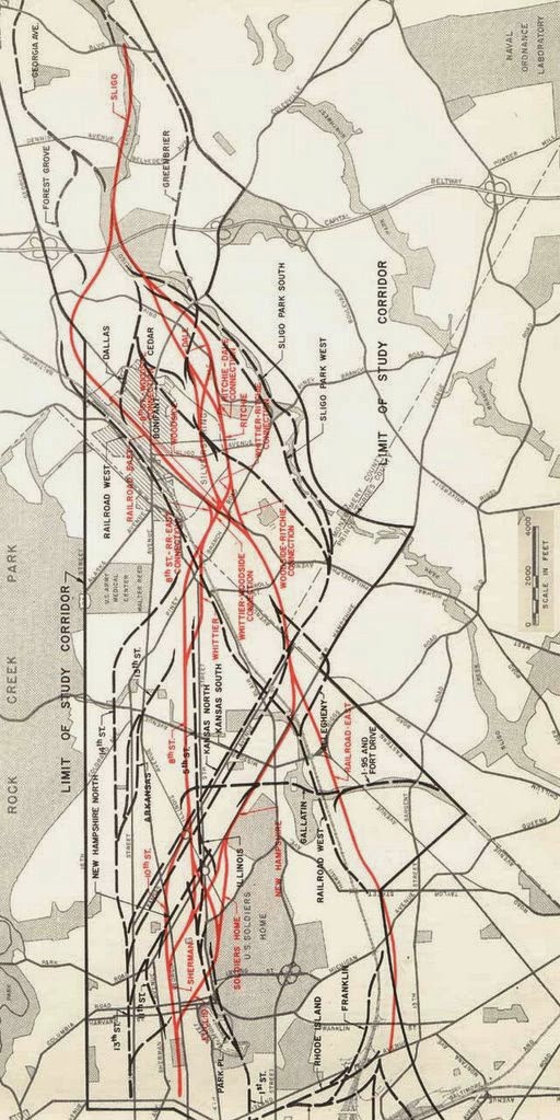
 1962 proposed rail transit and freeway Systems

A comprehensive freeway system with a greatly reduced footprint displacing a fraction of the dwellings of that proposed in the 1959 Mass Transportation Plan.

---

excerpted from pages 12-13  (also see pp24-29)

The Relocation Problem

The District of Columbia Highway department estimates that construction of the interstate highway portion of the 1959 plan would displace some 28,000 persons.  The Agency estimates that construction of all the highways proposed in the 1959 plan, excluding the portions already under construction would displace some 33,000 persons in the District of Columbia alone, or almost five percent of the District's population.  In contrast a rapid transit system will be constructed for the most part under the streets or on existing right of way and, together with the necessary highways, will displace only about one sixth as many persons.  Under the 1959 plan there would also be substantial displacement of schools, churches and businesses, to say nothing of the serious disruption of neighborhoods by the construction of highways through heavily built up areas.

The Solution

As a result of its studies the Agency recommends a balanced transportation system composed of:

1. A regional rapid transit system designed to encourage a high degree of utilization of public transportation for trips to and through downtown (Map B page xiii)

2.  An expanded highway system complementing the rapid transit system.  (Map C, page xiii)  This highway system is designed to provide a high level of freeway service to the region while reducing to a minimum problems of relocation, tax loss and impact on the character of the city.

  1962 Freeway Plan
narrow lines represent smaller scale parkways or trenched
grade separated "express streets"


excerpted from pp 43-46

Downtown Freeway System

The agency's highway plan includes an inverted "T" within downtown Washington connecting the central bridges with freeways leading to Montgomery and Prince Georges Counties.  the "T" includes major elements of the inner loop proposed in the 1959 plan.  (Map E).  However, the North Leg of the previously proposed loop is replaced by an express street system that would provide adequately for traffic requirements and at the same time preserve desirable neighborhood characteristics and fit in with any future plans for neighborhood improvement.  The agency's studies how that such improved street facilities would be adequate for traffic movements in the area which the North leg would serve.  The precise design of the system for accommodating such traffic can be worked out through the joint efforts of the Agency and the District of Columbia highway department.

The Agency's studies similarly show that the East Leg of the previously proposed loop is not required since it can be satisfactory replaced by a high speed route through Fort Drive.

[Note: this 1962 report's map shows this as a thick line partially along Eastern Avenue, hence showing it as a 6 or 8 lane freeway like the Inner Loop East Leg, but routed further north, neither along 11th Street NE/SE as proposed in 1955, nor to the east Capitol Street- RFK Stadium area as subsequently planned].

Here again the precise means of routing traffic around the eastern part of the city can be worked out through the joint efforts of the agency and the District Highway department.

Construction of the "T" involves
(a) Extending the Southeast Leg to 11th Street and across the Anacostia River to Route 295; and

(b Constructing an underground freeway below the Mall from Third and C Streets SW to the vicinity of Third and C Streets NW, and a depressed freeway from there to New York Avenue and Florida Avenues.  This Third Street leg will not require use of any part of the Capitol grounds.  in the vicinity of New Jersey Avenue it will be integrated with proposed urban renewal projects.

The "T" will provide superior access to downtown commercial areas and at the same time will enable substantial numbers of autos and trucks going elsewhere than downtown to bypass the center of the city.  The Agency's studies show that each leg of the "T" will carry some 7,000 vehicles in each direction during the peak hour in 1980 at speeds average 20 to 25 mph compared with 10 miles per hour today on existing streets.  during the off peak hours, speeds will average 40 miles per hour.  as noted in Chapter III, the "T" will substantially relieve downtown street congestion.


 Routes 70-S and 95 in the District of Columbia and Maryland

 "Significance of Using B&O Route. Use of the Baltimore & Ohio Railroad corridor to bring Routes 70-S and 95 into the city is the key to meeting the need for additional highway capacity in northern Washington, Montgomery County and northwestern Prince Georges Counties and at the same time avoiding the substantial relocation of persons, loss of taxable property and disruption of neighborhoods that would result from construction of the Northeast, North Central and Northwest Freeway proposed in the 1959 plan. Further savings are realized by placing the rapid transit line to Silver Spring and Queen’s Chapel in the same railroad corridor."


Route 66 in Virginia

This route is already under construction outside the Capital Beltway, and land acquisition has begun inside the Beltway.  Under the Agency's plan, Route 66 will have six lanes except between the Airport Access Road junction and Four Mile Run.  Between these two points the capacity will be increased to eight lanes.  From Route 66 to Arlington Boulevard, a short spur through Four Mile Run will be needed as will improvements of the Boulevard.  it is pointed out in chapter III that because trucks are not permitted to use the Theodore Roosevelt Bridge, a connection with the Shirley Highway bridges will be made via the Jefferson Davis Highway to accommodate route 66 truck movements.

Route 95 in Virginia

The Virginia Department of highways proposes to widen Shirley Highway to a 3-2-3 lane configuration.  The middle two lanes will be reversible so that five lanes will be provided in the direction of heavier traffic flow.  the Shirley Highway improvements proposed by the Virginia Department of Highways have been incorporated by the Agency's plans.  Minor modifications to permit development of express bus service and transfer of bus passengers to the proposed rapid transit lie near the pentagon are presently being discussed with the Department and the bureau of public Roads.

Other Major highway and Street Improvements

For proper operation of the downtown freeway plan, two projects are essential: (a) construction of a highway on Fort Drive between the junctions of routes 95 and 70-S and on Kenilworth Avenue Expressway, and (b) the development of an express street system to replace the proposed North Leg.  The Fort Drive route will require only a small amount of new right of way since much of the land has already been reserved for highway purposes.  In latter years it will be necessary to widen Kenilworth Avenue and the Anacostia Freeway.

The express street system that would replace the North Leg of the previously proposed Inner Loop system would be connected directly with the downtown freeway system and would in general follow the location of the North Leg route.  From the west it would be below grade most of the way to Connecticut Avenue and would be four lanes wide.  Between Connecticut Avenue and the junction of Florida and Rhode Island Avenues, the system would be at street level and would be under-passed at several crossings.  Between Rhode Island Avenue and New York Avenues the system would again be below grade.

The agency has already made extensive studies of the proposed express street system.

[Note- there is an "S Street Express Street Study Report" that I have seen at the library of the U.S. National Capital Planning Commission for a depressed roadway similar to the depressed segments of North Capital Street].

It proposes to conduct further studies in collaboration with the National Capital Planning Commission and the District Department of highways to work out the precise means of accommodating vehicular traffic in ways most advantageous to the neighborhoods.

In the Bethesda area two major road improvements will be required: (a) grade separating Wisconsin Avenue or nearby parallel streets at key intersections and (b) widening Little Falls Branch Parkway, and connecting it to Wisconsin Avenue and the George Washington Memorial Parkway.


1962 freeways- close up


1962 rail transit plan

The 1962 report had a greatly increased rapid rail system then that proposed in the 1959 report.


1962- rail transit system

1962- downtown rail transit subway system
pp 31-42

The principle features of the express transit system are:

1.  Two subway routes crossing twice within downtown to provide an extensive distribution and collection system.  This will provide fast service throughout downtown, speeding rush hour trips and improving circulation of downtown traffic in off peak hours

2.   Extensions of the downtown system throughout the district and suburban areas via seven rapid rail transit routes and one commuter route.

3.   Stations and paring areas, designed to meet the needs of the auto age and to serve as local distributions and collection centers.

4.   Express and local bus services in the district and throughout the suburbs with convenient connections to the high speed trains
.

The rail rapid transit system will be 83 miles long and will be served by 65 stations.  Nearly 19 miles will be underground.  Some 26 miles of freeway median strips and 24 miles of existing railroad right of way will be used for the rail rapid transit system.  The Pennsylvania railroad line will be 15 miles log and will have seven suburban stations.  Express bus operations will be provided on 52 miles of freeway and parkway.

The Downtown Subway

The downtown subway network is the heart of the regional transit system.  The pattern of this central underground system has been guided by existing and potential development of the downtown area, and has been designed to provide convenient connections between all major concentration of downtown activist, including federal and private office and commercial areas.  It is essential to unify and strengthen Washington,'s central area and to facilitate travel within this area.

An east west route (see "A" on map) will bring trains from Anacostia and southeastern Prince Georges County into downtown.  From the Navel Weapons plant it will proceed to a station at the Capitol with convenient access to the Senate and House Office buildings.  Other stations will be located at the Municipal center (judiciary Square) and in the heart of the downtown commercial area at 8th and g, NW . (Old patent Office Building) and at 12th and g Street NW.  The stations along G Street will stretch almost continuously from 7th to 13th Streets, with entrances at all major crossings and key commercial and office buildings.

After passing the Treasury and the White House, the east-west route will continue along Pennsylvania Avenue, turn down 21st street, and proceed to Virginia via a tunnel crossing of the Potomac River in the vicinity of Memorial Bridge.  Stations will serve the newly developing employment centers at 18th and Pennsylvania Avenue NW, and at 21st and E NW, near the State Department.

A north-south route (see "B" on map) will bring trains into downtown from the northeastern and north central portions of the District and from Montgomery County and northwest Prince Georges County.  At Union Station there will be a convenient transfer to the Pennsylvania Railroad commuter service.  From Union Station, the north south route will proceed to the Capitol, where there will be a direct transfer to the other route.  The north-south route will then proceed into the new employment area near south of the Mall, with stations at 4th and independence s and at the new 10th Street mall redevelopment area near C Street, and one at 12th and G Street NW, where riders can transfer to and from the other route.

The north-south route will then turn westward, with stations at 14th Street and I, NW, and Connecticut and K NW, serving the highest density office development in downtown Washington.  From there the route will go to the Northwest and to Columbia Heights with downtown stations at 18th and P NW, adjacent to DuPont Circle, and at 19th and Florida, providing access to the Connecticut Avenue commercial and office area.

Although a major function of he subway will be to distribute rapid transit riders from the outlying residential area, the system has been designed also to provide swift service for trips confined to the downtown area.  Trips by subway service between points such as the State Department and Capitol Hill or the Federal Triangle and DuPont circle will be made in a fraction of the time they now take on surface streets.  (Figure 16).  Still another important function of the downtown subway will be to provide a fast through route for persons crossing the central area.  It will thus reduce the number of auto trips through the heart of the city.

Stations

The 14 downtown subway stations have been located so that almost 80% of the persons employed downtown will be less than five minutes walk from a station to their place of employment.  (Figure 17).

Each station will have a separate pedestrian level - a mezzanine, located between the street and the train tracks and served by escalators.  For the convenience of patrons and in order to lesson congestion on the streets, the mainlines will provide access to several corners at major street intersections.  The mezzanines will have space available for concessions, providing additional revenue for the system, and will allow direct underground access to many of the downtown office and commercial buildings.

Because American cities have built few subways in recent years, the Agency's concept of modern subway design has been influenced by systems recently built in Toronto and in a number of European cities, such as Stockholm.  Subways in these cities have clean and brightly lit interiors, with architecturally designed surfaces, modern ventilation and air conditioning and a low noise level.  Subway stations are designed to minimize walking, just as the service itself is designed to minimize waiting on the platform.  Changes in level are accomplished without effort by escalators and other modern mechanical devices.  All of these modern architectural and engineering design features will be incorporated in the proposed downtown subway.

Radial Train Route

Eight rail transit lines will be part of, or will connect with the downtown subway system.  (Map I).  While the precise location of some segments of these lines is still to be determined, there is no question as to the major corridors to be served.  In some corridors final determination of route and locations of stations will have to await more extensive engineering studies and further consultations with local officials.

The eight rail lines will extend into the most densely populated areas of the District and the suburbs.  the lines have been placed to serve the greatest numbers of people- and thereby to generate as much revenue as possible per dollar of capital outlay, and they have also been planned to minimize costly subway construction outside of the downtown area.  Two of the lines will use railroad rights of way and three others will make extensive use of median strips of proposed highways.  A sixth line will provide modern commuter service on the existing electrified tracks of the Pennsylvania railroad.  On the remaining two lines subway construction has been avoided where it has been possible to do so.

The Agency has had extensive discussions with the railroads concerned; all have indicated their interest in the proposed project and their willingness to cooperate.  The agency made a special study of the sue of railroad rights of way either for rapid transit service or for conventional commuter rail service.  The conclusions set forth as herein will be explained in an appendix volume:

The eight rail lines are as follows:

1.  Northwest Bethesda.  A line from Pooks Hill in Montgomery County will pass through the northwest corridor of Bethesda and the District, down Connecticut avenue to Farragut Square and across downtown to the Capitol.  for most of the way in the District the line will be tunneled underground.

2.  Columbia Heights Pentworth.  This relatively short, two mile spur will provide service for most of North Central Washington.  The line will be underground most of the way.  It will begin near Georgia and New Hampshire Avenues, proceed to Columbia Heights and join the northwest line at 19th and Florida Avenue.

3.  Rockville-Silver Spring.  Using the right of way of the Baltimore and Ohio railroad, a radial will pass through central Montgomery County, the upper north central portion of Washington, and a portion of northeast Washington.  It will go underground at Union Station and lead directly to the Capitol and downtown.

4.  Route 95-Queens Chapel.  A line on the median strip of Interstate 95 will originate outside the Capital Beltway, pass through northwestern Prince Georges County and join the Rockville line inside the District of Columbia.

5.  Bowie County.  Modern commuter railroad service will be provided on the Pennsylvania Railroad from bowie through Lanham and Cheverly.  All stations will be in Prince Georges County.  The service will be fast and frequent.  Trains will bring passengers directly to the subway platforms at union station for n easy transfer to all downtown points.

6.  Henson Creek-Anacostia.  A combined surface and subway line will bring passengers from south-east Prince Georges County and southeast Washington to downtown.  A major transfer station in Anacostia near Good hope Road will connect with bus lines serving the corridor between South Capitol Street and Pennsylvania Avenue.  After crossing the Anacostia river, the line will lead into the Capitol area and thence downtown.

7.  Springfield-Alexandria.  This line will use the right of way of the Richmond, Fredericksburg & Potomac Railroad and the Southern Railroad over much of its length.  The line will begin in Springfield, and then pass through Alexandria to the Pentagon.  It will then proceed under the Potomac into downtown.

8.  Route 66-Roslyn.  Using the media strip of Interstate 66 in Fairfax County and portions of Arlington, a rapid transit line will provide service from the city of Fairfax through central Fairfax County, East Falls Church and North Arlington.  It will join the Springfield line on the Virginia side of the river.


Rapid Transit Service

Service on the rapid transit system will be rapid and frequent.  Overall speeds, including station stops, will average between 45 and 50 miles per hour between the suburbs and downtown.  Downtown trains will operate a minute and a half apart during the peak hours.  Modern, lightweight equipment will be far superior in comfort and performance to that in use on existing domestic rapid transit systems.  the vehicles will be quite modern as those usually associated with so-called monorail systems (which the Agency does not propose to use because, among other reasons, of he cost of placing them underground; see chapter V and the Appendix).  The vehicles will be attractive to look at and comfortable to ride in; they will be air conditioned and well lighted.  In the open, they will run, for the most part, along freeway and railway rights of way; occasionally they will use aerial structures.  Modern insulating methods and track construction will keep noise to a minimum.

As shown in figure 18 the system will provide a fast service to downtown from all points in the region.  it will be a dramatic improvement over present transportation in both time and comfort.  A detailed listing of the new travel times is given in the following table.


Two hypothetical trips serve further to illustrate the revolutionary change in regional travel times that rapid transit service will introduce.

A peak-hour trip from Silver Spring to the Federal Triangle today takes an average of 45 minutes by bus.  A rapid transit passenger who drives his car to the station at silver spring will be able to make the same trip in 8 minutes, 38 percent faster than today's bus trip.  A feeder bus passenger will be able to make the trip in 33 minutes, 27 percent faster than today's bus times.

Many commuters will continue to use their automobiles from suburban homes to central city work places.  Salesmen, doctors and others need the flexibility of personal transportation.  But the overwhelming number of daily commuters are routine travelers, interested  mainly in travel time comfort, and economy.  Satisfying their needs by efficient, modern public transportation is the major step forward toward a more balanced urban transportation system.

Express and Local Bus Service

Express bus service will be developed on several freeways and express parkways.  In addition to the new express service, existing local bus service will serve areas not covered by the regional rapid train routes, and new local bus service will be developed to feed the train routes, particularly in newer suburban areas.  the express bus routes will include:

George Washington Memorial Parkway.  This route will begin along the Potomac River at Cabin John and use the new parkway into the District to downtown.

Suitland Parkway.  This line will use the parkway into the district and then transfer all passengers to the Henson Creek train line at Alabama Avenue.

Anacostia-Boiling.  this line will serve the Federal installations at the Naval Research Laboratory and at the Anacostia and Boiling facilities and will be connected to the Anacostia station.

Shirley Highway.  Frequent service, using the widened Shirley Highway, will be operated between Duke Street- Lincolnia and the Pentagon area.  All passengers will transfer to the Springfield train line for quick service downtown.

---


See the full Recommendations for Transportation in the National Capital Region: A Report to the President for transmittal to Congress by the National Capital Transportation Agency November 1, 1962 document here:
http://wwwtripwithinthebeltway.blogspot.com/2012/02/november-1-1962.html
---

This November 1, 1962 report stands in marked contrast to the status quo to come, with its intent was to build BOTH the freeways and the WMATA system.

The popularization of the idea of simply not building a continuous Washington, D.C. freeway system would come in the wake of the October 1964 North Central Freeway report that failed to follow the 1962 report's prescription for that freeway to strictly follow the B&O railroad corridor that runs alongside Catholic University of America.
http://wwwtripwithinthebeltway.blogspot.com/2012/01/crafted-controversy-scuttling-of-jfks-b.html
http://wwwtripwithinthebeltway.blogspot.com/2015/01/feds-stoked-controversy-over-dc.html

In the time since, mainstream media accounts of this history have been overly generalized.  They apply criteria against building new urban freeways that is strangely not applied to urban railways; nor do they consider such projects elsewhere from around the world as that in Madrid.  Nor is such applied to new real estate development placed so close to existing urban freeways and railways, as to complicate reconstructing such underground to reconnect local neighborhoods, such as with new linear parkland in areas of the city were such is rare.  Though, for instance, people in Brookland, D.C. favored a proposal to cover the existing B&O railroad, the whims of Catholic University of America to remain isolated by the existing surface railway would take prominence.


Meanwhile, revisionist accounts by WMATA have presented a differing dichotomy of building the rail transit system or the freeway system, neglecting the history that the two systems were planned to be constructed together.
http://wwwtripwithinthebeltway.blogspot.com/2011/12/wmata-pushing-false-dichotomy-of-them.html

It's as if people were being distracted from asking questions about why a nation as wealthy as the United States of America was somehow too poor to afford building both the rail transit and freeway systems, particularly in the city that happens to be the Nation's Capital.

As an example. just consider the example of failing to question the cancellation of the Westway highway tunnel project in New York City, that would have created acres and acres of new land with permanently taxable new real estate development, just prior to that State embarking upon perhaps its biggest spending spree ever in police enforcement and prison construction for the sinfully wasteful 'drug war'.

Was it any wonder that this either-or mythology on transit and urban freeways was promoted in part by the Tobacco-pharma power house law firm of Covington & Burling?
http://wwwtripwithinthebeltway.blogspot.com/2009/10/ectc-paid-to-riot-via-covington-burling.html
http://wwwtripwithinthebeltway.blogspot.com/2009/12/peter-s-craig-editorial-reply.html

For more on the 'drug war' see my companion blog 'Freedom of Medicine And Diet'
http://freedomofmedicineanddiet.blogspot.com/
Anyone interested in urban planning should be appalled at the tremendous waste of money and lives spent on the 'drug war'.

Tuesday, January 13, 2015

Feds Stoked Controversy Over D.C. Freeways By Keeping EARLIER Routes as Official?


U.S. Federal Highway Authority (FHWA) has a web page about the 'de-mapings' of the various freeway systems, including that near and within Washington, D.C.
http://www.fhwa.dot.gov/highwayhistory/data/page05.cfm

Weirdly, that page , shows the earlier routings for the northern portion of the Inner Loop and the 1964 routing for the North Central Freeway (with the 1967 routings for the South Leg and the East Leg).


It completely disregards the extensive evolution of the highly controversial I-66 North Leg routing via the open trench and raised berm along Florida Avenue and U Street being replaced by the I-66 North Leg K Street Tunnel.

The I-66 K Street Tunnel alternative had the later 1960s support of both the D.C. City Council and U.S. NCPC, with the District Department of Public Works being the sole hold out favoring the U Street plan until late 1969 or early 1970.

The highly unpopular Open Trench and Raised Embankment Along Florida Avenue and U Street

 The plan initiated by opponents to the Florida Avenue-U Street Plan:
the I-66 K Street tunnel
 
http://www.roadstothefuture.com/DC_Interstate_Fwy.html

The I-66 portion of the North Leg of the Inner Loop would have extended from the present I-66 terminus near the Watergate Apartments at K Street NW, extending as the North Leg under K Street NW in a tunnel, and emerging east of Mount Vernon Square and junctioning with I-95 about a mile north of the U.S. Capitol Building. The I-66 portion of the North Leg would have had 6 lanes. The I-66 K Street Tunnel was the solution to the original I-66 alignment that would have run east-west through urban neighborhoods alongside Florida Avenue NW, and between T and U Streets NW about a half mile north of K Street NW. If the K Street Tunnel had been built, it would have been a cut and cover design, about 1.5 miles long, buried out of sight under the straight 147-foot wide avenue, and passing under Mount Vernon Square, and it would have run from near Watergate almost to today's New York Ave./I-395 junction. I-66 crosses the Potomac River from Arlington, Va. to D.C. on the Theodore Roosevelt Bridge, which opened on June 23, 1964.

Likewise the FHWA page on the 'de-mapings' shows the extremely unpopular 1964'Recommended route" #11 'Railroad-Sligo East' version of the B&O Route- which was widely, strongly and legitimately opposed.


  This map of the freeways 'de-maped' during the 1970s
shows the 1964 version of the North Central Freeway
that deviates from the B&O railroad


 1964 version of North Central Freeway 
deviates from B&O railroad just north of New Hampshire Avenue


 1966 version of the North Central Freeways
stays with the B&O railroad- here shown at New Hampshire Avenue


The opposition to the 1964 North Central Freeway plan was so strong that the authorities had to return 2 years later with the 'supplementary' North Central Freeway study report of November 1966 for a low level B&O route more or less conforming to the 1962 JFK vision.  That report included an illustration of a possible decking over of the freeway alongside the main body of Catholic University of America as well as a bit to the south- though fails to include any isometric drawings in detail as done in 1963 and 1965 with the Fenway segment of the proposed Boston Inner Loop.

Proposed park atop Boston Inner Belt- 1965

Proposed lid atop North Central Freeway CUA area- 1966

As can be gathered from a 1967 letter to Maryland Governor Spiro Agnew by Takoma Park resident Duncan Wall, replacing the 1964 plan with the 1966 plan had caused the opposition to largely die down, only to be renewed again with the waffling of authorities, particularly within the then brand new US FHWA to re-consider using the 1964 plan as 'cheaper':

http://wwwtripwithinthebeltway.blogspot.com/2012/01/crafted-controversy-scuttling-of-jfks-b.html
Citizens of Takoma Park and Silver Spring had reason for their demonstrations of bitter dissatisfaction with the highway authorities of your predecessor's administration. After we had been given reason to believe that the causes of our protests had been in at least some part overcome, the matter now threatens to break into renewed bitterness. I am sure you will wish to avoid this as much as many of us....

The re-studied proposal also tacitly admitted that the route first proposed was needlessly, even carelessly if not ruthlessly, destructive of our communities. The new version hugged both sides of the existing Baltimore and Ohio railway, thus avoiding a new swath of destruction to divide our communities and sharply reducing the number of homes to be taken.

The reduced, re-routed proposal was made public last year with endorsement of D.C. And Maryland highway authorities. The D.C. Portion was forced through the National Capital Planning Commission by votes of representatives of the D.C. Highway Department and of the U.S. Bureau of Public Roads. From this we concluded, reasonably enough, that the highway authorities of the two jurisdictions (Maryland and D.C.) had reached a firm understanding with the Bureau of Public Roads.

Many of us were therefore astonished and aroused to preparations for renewed protests when Washington newspapers recently reported that the Bureau has acted to open it all up again. We have not found the Bureau forthcoming with candid information, but the press articles intimate an intention to force Maryland to accept modifications of route or design ostensibly "cheaper."

The result is that the whole controversy, which had been somewhat quiescent, is beginning to agitate the communities again. I can assure you this is so, for although I recently resigned chairmanship of the Metropolitan Citizens Council for Rapid Transit and write this simply as an individual citizen who wishes your administration well, I do remain in close touch with neighborhood sentiment on transportation-related issues.
As reported by The Washington Post, May 8, 1967:
Top officials of the Bureau have ordered a full review of the plans for the 3 ½ mile road … While it is good practice to disrupt as few people as possible in road building, is it worth the added cost of $22 million?

… Rejection by the Bureau would certainly fan the embers of one of the Washington area’s freeway controversies spearheaded by a group called the Save Takoma Park Committee. It rallied the residents of the middle income suburb composed largely of turn of the century homes on tree lined streets to strident opposition at hearings in Washington and Silver Spring on the original [1964] alignment.
http://wwwtripwithinthebeltway.blogspot.com/2012/01/crafted-controversy-scuttling-of-jfks-b.html
A cost savings of $22 million would translate percentage wise to 12.3%, given the approximately $271 million cost given in the 1966 'Supplementary' North Central Freeway Engineering Report for the B&O Low Level Option.

Such was why the D.C. City Council and U.S. NCPC would reverse their long standing support for the JFK B&O freeway concept by the end of 1968:


February 6, 1967: presentation of the new B&O Low Level North Central Freeway plan to NCPC
May 1967: NCPC approves 1st link of North Central Freeway
October 1967: NCPC approves final link of North Central Freeway 8-2
February 1968: law suit decision by U.S. Court of Appeals
February 17, 1970: D.C. City Council votes against North Central Freeway
September 17, 1970: legislation in Congress in the House Public Works Committee ordering North Central Freeway construction.
April 9, 1972: Maryland drops I-70S
February 1973: Maryland drops I-95 by the Northwest Branch Park corridor.
July 16, 1973: Maryland drops I-95 via the PEPCO right of way.
 
Also see:

The following maps show the DC freeway system as the design had evolved by the 1970s:


The federal action of retaining the earlier unpopular routings is consistent with the crafted controversy of the scuttling of the B&O route via the 1964 betrayal of the recently assassinated JFK's planning, the FHWA cir 1967-1968 waffling, along with such things as the highly questionable "support" of such organizations as the Federal City Council.


Should not the FHWA de-maping page instead show maps as these found on Scott M. Kozel's informative site Roads to the Future - and that below of what Maryland canceled in July 1973?

PEPCO-B&O I-95

I was once told by an elderly lady involved with the anti-freeway protests of the 1960s and 1970s that despite the design and routing evolution of that time that had lead to the development of plans that were far far less controversial, that the Feds in fact had formally retained the infinity more controversial earlier plans, thus crafting the levels of anti urban freeway sentiment sufficient to bring about the 'de-mapings.'

I had found that too incredible to believe particularly with the design evolutions that had occurred.  However, the FHWA 'de-maping' page shows maps backing that up.

View the page for yourself:

http://www.fhwa.dot.gov/highwayhistory/data/page05.cfm

Withdrawal of I-70S, 95, 66, 266, 295, 395 &695 -- Washington, DC

Description of Withdrawn Routes
The withdrawal of seven Interstate Routes or portions thereof (I-70S, I-95, I-66, I-266, I-295, I-395 & I-695) in Washington, DC was accomplished in six stages.
Withdrawal Action
Stage One

On June 27, 1975, Mayor Walter E. Washington requested the withdrawal of two segments from the Interstate System: (a) I-95 between I-295 and the Maryland State line and (b) all of I-70S in the district.

On October 3, 1975, Federal Highway Administrator Norbert T. Tiemann and Urban Mass Transportation Administrator Robert E. Patricelli approved the withdrawal of the two routes under the provisions of 23 U.S.C. 103(e)(4). The withdrawal removed 5.4 miles in DC from the Interstate System.

In accordance with Section 103(e)(4), DC's unobligated balance of Interstate Construction (IC) funds was increased by approximately $159.2 million to $304.3 million since the withdrawal was approved prior to the May 5, 1976, enactment of the Federal-Aid Highway Act of 1976. The increase was accomplished by increasing DC's IC apportionment for FY 1977.

Stage Two

On December 29, 1976, Mayor Walter E. Washington requested the withdrawal of two more segments from the Interstate System: (a) the portion of I-66 between I-266 and I-395, and (b) the I-266 Three Sisters Bridge over the Potomac River to the Virginia State line. The two route portions total 2.50 miles.

On April 29, 1977, Federal Highway Administrator William M. Cox and Urban Mass Transportation Acting Administrator Charles F. Bingman approved the withdrawal of the two routes under the provisions of 23 U.S.C. 103(e)(4).

In accordance with Section 103(e)(4), DC's unobligated balance of IC funds was decreased by approximately $103.5 million accomplished by decreasing DC's IC apportionment for FY 1977.

Stage Three

On August 7, 1978, Mayor Walter E. Washington requested the withdrawal of portions of the East leg and North Leg Freeways (I-295 and I-395).

On September 8, 1978, Federal Highway Administrator Karl S. Bowers and Urban Mass Transportation Administrator Richard S. Page approved the withdrawal under the provisions of 23 U.S.C. 103(e)(4). The two route portions total 4.70 miles.

In accordance with Section 103(e)(4), DC's unobligated balance of IC funds was decreased by approximately $130.1 million accomplished by decreasing DC's IC apportionment for FY 1977.

Stage Four

On April 30, 1980, Mayor Marion S. Barry requested the withdrawal of a 1.7-mile segment of the South Leg Freeway portion of I-695 between I-66 and I-395.

On August 27, 1980, Federal Highway Administrator John S. Hassell and Urban Mass Transportation Deputy Administrator Lillian C. Liburdi approved the withdrawal under the provisions of 23 U.S.C. 103(e)(4). In addition a 0.12 mile segment of I-695 was deleted from the Interstate System under Section 103(f).

In accordance with Section 103(e)(4), DC's unobligated balance of IC funds was decreased by approximately $45.9 million accomplished by decreasing DC's IC apportionment for FY 1980.

Stage Five

On January 27, 1982, Mayor Marion S. Barry requested the withdrawal of the westerly 0.6-mile segment of I-266 between the Three Sisters terminus and Key Bridge.

On June 28, 1982, Federal Highway Administrator R. A. Barnhart and Urban Mass Transportation Administrator Arthur E. Teele approved the withdrawal under the provisions of 23 U.S.C. 103(e)(4).
In accordance with Section 103(e)(4), DC's unobligated balance of IC funds was decreased by approximately $10.8 million accomplished by decreasing DC's IC apportionment for FY 1982 and 1983.

Stage Six

On May 19, 1983, Mayor Marion S. Barry requested the withdrawal of (a) the remaining 0.51-mile segment of I-266 and (b) a 0.25-mile segment of I-66 within the I-66/I-266 interchange area.

On August 19, 1983, Federal Highway Administrator R. A. Barnhart and Urban Mass Transportation Acting Administrator G. Kent Woodman approved the withdrawals under the provisions of 23 U.S.C. 103(e)(4).

In accordance with Section 103(e)(4), DC's unobligated balance of IC funds was decreased by approximately $12.9 million accomplished by decreasing DC's IC apportionment for FY 1983.
Withdrawal Value
The "Base" withdrawal value was based on the Federal share of the cost to complete these Interstate routes as reported in the Interstate Cost Estimate (ICE) at the time of the withdrawal. The Base cost was adjusted quarterly to determine a new withdrawal value in accordance with Section 125 of the Federal-Aid Highway Amendments of 1974 reflecting variations in the cost of construction. The adjustment due to construction cost variances was terminated by the Surface Transportation Assistance Act of 1982. These values are shown in the following table:

Withdrawal Value & Obligations -- Washington, DC
Stage One Base Cost (1975 ICE)304.3 million
Stage Two Base Cost (1975 ICE)300.6 million
Stage Three Base Cost (1977 ICE)403.5 million
Stage Four Base Cost (1979 ICE)230.4 million
Stage Five Base Cost (1981 ICE)110.2 million
Stage Six Base Cost (1981 ICE)121.8 million
Obligations for Highway Projects233.4 million
Obligations for Transit Projects1,963.5 million
Remaining Entitlement0.8 million
Final Withdrawal Value2,197.7 million


Map of Washington, DC Stage 1 Interstate Highway withdrawals
Map of Washington, DC Stage 2 Interstate Highway withdrawals
Map of Washington, DC Stage 3 Interstate Highway withdrawals
Map of Washington, DC Stage 4 Interstate Highway withdrawals
Map of Washington, DC Stage 5 Interstate Highway withdrawals
Map of Washington, DC Stage 6 Interstate Highway withdrawals
Map of Washington, DC Stage 7 Interstate Highway withdrawals


See some detailed histories here:

http://wwwtripwithinthebeltway.blogspot.com/2012/01/crafted-controversy-scuttling-of-jfks-b.html
http://wwwtripwithinthebeltway.blogspot.com/2014/09/getting-over.html
And see this as an example of how media entities over simplify the history- willfully.
http://wwwtripwithinthebeltway.blogspot.com/2015/01/the-washington-city-papers.html

Friday, January 09, 2015

Answering a Critic


       B&O-PEPCO I-95

See comments at:  

The only thing that hasn't changed in the last 40 years in the corridor in question is that nobody wants this highway?!  *Nothing* in them is valid anymore?!-  

A baseless claim, regarding a later freeway routing option.  One on the books for only a few months in 1973; at the tail end of a crafted controversy against its connecting segment within the District; that itself was relatively uncontroversial, until becoming highly politicized for reasons unrelated to its basic feasibility.

It's the same right of way.  The same topography.  Virtually the identical development, with the one main difference being that eminent domain special development upon the connecting segment just inside the Distract: the Comstock ‘Hampshire’s’ project.  Which anyone buying into was warned via my blog, so they knew they were buying an eminent domain demolition special that should have not been approved. 

It's a different generation.  One that has seen the fallacy of pretending that WMATA serves as a substitute rather than a supplement to highways  40years after the wholesale cancellation of the unbuilt inside the Maryland Beltway freeway system - resulting in some of the worst traffic problems in the US!  One that may be far more skeptical of the whole idea that a nation as rich as the U.S.somehow HAD to de-map the freeway system to fund the WMATA system- particularly given the 100s of billions squandered in the drug war.   And one that may be aware of more innovative urban highway projects elsewhere done right to blend into the urban fabric in a more benign indeed complimentary fashion from Boston, Massachusetts, to Madrid, Spain.  In a state where highway expansion - dualizations and grade separations - have been derided as a simple means to fund what may be worthy transit projects - the Maryland election of a new Governor with votes from areas acknowledged as favoring better highways and questioned the simple prioritization of transit at the expense of highways may portend a change, perhaps on a broader scale: that perhaps we should re-think certain transit projects, either defer them, or at least work out some better financing from the new development that would rely upon them, to lessen the financial burden on official budgets in areas that have not simply deferred highway projects, but rather pretended that such should never be built.

Also, completing an unwanted plan is pretty much the worst justification for a project ever. I am completely aware of what these old studies were advocating. They were widely rejected for a host of reasons.

Unwanted by who, what, and why?   

http://wwwtripwithinthebeltway.blogspot.com/2007/02/sampling-of-attitudes-towards-dc-i-95.html

The PEPCO I-95 extension plan was the result of popular sentiment against the longstanding plan, from the 1950s to February 1973 for the inside the Beltway I-95 extension via Northwest Branch Park routing.  That plan would have taken about 100 acres of parkland along a stream, plus about 110 residences in Maryland, entering the District via the Fort Drive right of way, taking 0 homes there between Gallatin and Galloway Streets- and was opposed within Maryland for the parkland stream corridor impacts.  The PEPCO I-95 alternative first appears only in the 1971 Deleuw, Cather, Weese study, and was written up highly favorably for using an existing non stream corridor 250 foot wide clear-cut, so noting the feasibility of re-aligning the power-lines, including the option of burying them, and the superior geometry of the new Hampshire Avenue corridor extension connecting with North Capitol Street and Missouri Avenue providing better serviceability access into the north-south and east west street grid into northern Washington DC.

I ask yet again, what travel demand would this project satisfy? That couldn't be addressed with widening 295? Where will all these cars park? Why should thriving neighborhoods be destroyed to save a guy from Columbia a few minutes commuting time?

Service into, and for northern Washington, D.C. as well as through traffic.  Widening I-295 (and hopefully modernizing it with full shoulders and some cut and cover tunnels as local mitigation) can serve the latter but not the former.  To go through SE to get to NE or NW?  Why must traffic go way out of its way through a poorer area that still awaits mitigation, while dismissing largely cut and cover existing right of way links into wealthier areas?

Neighborhood destruction?  It’s almost entirely existing right of way.   But for the final 1600 feet between its southern end and the District line, the PEPCO right of way is all of the 5.3 mile length from the beltway to the District line, with that final stretch consisting of retail strip properties.   What neighborhoods, asides from a portion of such along the north side of New Hampshire Avenue, primarily along a less than one block segment of Eastern and Rittenhouse, consisting of only 27 mid 1900s brick houses within the next 1,600 foot extension between the Maryland-District line and the B&O corridor.  Oh yes, the brand new Comstock town-house project ‘The Hampshires’ just erected in the past two years- based upon purjurous testimony by USNCPC that did not even mention the transportation corridor significance- consisting of 110 new dwellings- with inhabitants that should have known about from this blog by simply doing an internet search upon what they were buying into.  Whether the figure is 27 or 27 plus the bulk of that Comstock eminent domain special, the figure is a low number to connect a some 5 mile right of way with that railroad industrial corridor that only requires another 30 or so for a total of 59 for the entire highway from the Beltway to the confluence of the B&O and New York Avenue- plus whatever is now being built looking to make a quick profit off of new dwellings that should have never been approved.

I don't understand the hostility you have for the neighborhoods and institutions that have been in place for over 100 years. Why should anyone consider displacing CUA for a highway?

What hostility for neighborhoods in general?  I have written that I oppose the earlier plans such as I-66 via a new swath through thousands of dwellings along Florida Avenue and U Street, and versions of the North central freeway likewise along Georgia Avenue, along with the infamous 1964 routing on a longer route away from the railroad through Takoma Park in 1964.  And I have written not to simply revive the plans as evolved radically from the 1950s to the 1970s- compare the 1950s version of the I-66 North leg and the replacement K Street Tunnel  plans as an example- but rather take the design evolution further to reduce impacts and improve operation-ability – such as connections between the proposed K Street Tunnel and the effective center leg extension to the northeast, relocating cut and cover tunnel segments respectively partially and fully alongside New York Avenue displacing 148 and 600+ (or rather 550+ as Mayor Anthony Williams tore some down about 15 years ago) to respectively entirely under the avenue taking 0 for an independent continuation of the I-66 tunnel, and as few as 33 for I-395 (I-95) with a tunnel arcing beneath the intersection of new jersey Avenue and N Street transitioning to a double deck configuration beneath O street, providing a 95% reduction in displacement with a gentler-superior transition radii- vital in a curved tunnel segment.   

See: http://wwwtripwithinthebeltway.blogspot.com/2007/11/i-395-extension-superior-option.html

Nonetheless that alternative has gone entirely unconsidered in the 1996+ Ron Linton I-395 tunnel extension planning despite its inferior geometry.  If anyone is being hostile, it is your position with regard to SE of the Anacostia.

Not institutions but rather institution.  

It was JFK that radically reshaped the transportation planning after the 1959 Mass Transportation Plan, greatly increasing the proposed rail transit system and significantly reducing but not eliminating the proposed freeway system to greatly reduce the impacts.

A main point of that was the reduction of three separate northern freeways with a single 2 into 1 “Y” route via the route with the least impact from the November 1962 report:
"Significance of Using B&O Route. Use of the Baltimore & Ohio Railroad corridor to bring Routes 70-S and 95 into the city is the key to meeting the need for additional highway capacity in northern Washington, Montgomery County and northwestern Prince Georges Counties and at the same time avoiding the substantial relocation of persons, loss of taxable property and disruption of neighborhoods that would result from construction of the Northeast, North Central and Northwest Freeway proposed in the 1959 plan. Further savings are realized by placing the rapid transit line to Silver Spring and Queen’s Chapel in the same railroad corridor."

1962 B&O Route 
with I-95 routed from the northeast via the Fort Drive routing 
connecting with that via Northwest branch in Maryland

That was a key point.  A study report on this was due sometime in the summer of 1963.  JFK and his wife meanwhile had an interest in urban planning; and he was likely aware of that at that time for the proposed Boston Inner Belt which featured proposed designs for partially encased box tunnel segments beneath new pedestrian promenades.    As JFK was from Boston and undoubtedly somewhat familiar with that area along with that alongside Catholic University of America (where the road there today is named after the 1962-1971 Speaker of the House, John William McCormick), I can wonder if he ever envisioned a design like that for alongside CUA.

 1963 Boston Inner Belt: park atop highway tunnel segment


1965 Boston Inner Belt: park atop highway tunnel segment

1966 D.C. I-95 North Central Freeway with cover alongside Catholic University of America

John W. McCormack

Whatever the case, no report upon that freeway would come out anytime in 1963.  The report that finally emerged in October 1964 was a mockery of the B&O route concept.  It had 37 routes all over the map.  Its recommended route #11 largely followed the B&O, but with serious deviations in Brookland and especially Takoma, creating a huge firestorm of controversy-opposition.   


 October 1964 North Central Freeway report
OVERVIEW
http://wwwtripwithinthebeltway.blogspot.com/2006/11/1963-64-north-central-freeway-study.html

REPORT - PLATES

http://wwwtripwithinthebeltway.blogspot.com/2008/05/1964-north-central-freeway-report-je.html

REPORT - FULL TEXT & CHARTS (Complete)
http://wwwtripwithinthebeltway.blogspot.com/2012/02/october-1964-north-central-freeway.html

REPORT - ON THE B&O ROUTE
'PIN POINT THE B&O CORRIDOR ONLY AFTERWARDS'

http://wwwtripwithinthebeltway.blogspot.com/2012/01/pin-point-b-rr-in-dc-only-after-more.html


 1966 North Central Freeway

http://wwwtripwithinthebeltway.blogspot.com/2006/11/1966-north-central-freeway.htmlhttp://wwwtripwithinthebeltway.blogspot.com/2006/11/1966-north-central-freeway.html

By November 1966 a ‘supplementary’ study report is released with a basic routing and design akin to the 1962 planning though little in the way of anything more exotic as the above mentioned promenade covered Inner belt box tunnels, though including one plate showing a potential decked over area alongside CUA and a little bit further south.  See the image captioned  “I-95 B&O North Central Freeway next to Catholic University of America” within: 


Then see what happened in 1967 after the controversy had died down only to be again inflamed by the then new UFHWA waffling between the infinity less opposed 1962/1966 planning and the infamous 1964 planning, as explained by this June 1, 1967 letter from Takoma Park resident Duncan Wall to Maryland Governor Spiro Agnew:
Citizens of Takoma Park and Silver Spring had reason for their demonstrations of bitter dissatisfaction with the highway authorities of your predecessor's administration. After we had been given reason to believe that the causes of our protests had been in at least some part overcome, the matter now threatens to break into renewed bitterness. I am sure you will wish to avoid this as much as many of us.

We showed that the methods of traffic projections which were claimed to justify the North Central were fallacious, the results in error by as much as 400 percent. Our contention was tacitly admitted in "re-studied" versions of the proposal made public last year, sharply reducing the original plan of 5 lanes each way.

The re-studied proposal also tacitly admitted that the route first proposed was needlessly, even carelessly if not ruthlessly, destructive of our communities. The new version hugged both sides of the existing Baltimore and Ohio railway, thus avoiding a new swath of destruction to divide our communities and sharply reducing the number of homes to be taken.

The reduced, re-routed proposal was made public last year with endorsement of D.C. And Maryland highway authorities. The D.C. Portion was forced through the National Capital Planning Commission by votes of representatives of the D.C. Highway Department and of the U.S. Bureau of Public Roads. From this we concluded, reasonably enough, that the highway authorities of the two jurisdictions (Maryland and D.C.) had reached a firm understanding with the Bureau of Public Roads.

Many of us were therefore astonished and aroused to preparations for renewed protests when Washington newspapers recently reported that the Bureau has acted to open it all up again. We have not found the Bureau forthcoming with candid information, but the press articles intimate an intention to force Maryland to accept modifications of route or design ostensibly "cheaper."

The result is that the whole controversy, which had been somewhat quiescent, is beginning to agitate the communities again. I can assure you this is so, for although I recently resigned chairmanship of the Metropolitan Citizens Council for Rapid Transit and write this simply as an individual citizen who wishes your administration well, I do remain in close touch with neighborhood sentiment on transportation-related issues.
Now- why would the planning so disregard that key point of the 1962 JFK plan?

Such inflaming of opposition would be sufficient for two main entities necessary for approving the highway to reverse their long standing support for the freeway by the end of 1968. Thus, what we have was a manufactured opposition, to a freeway that had previously been not very controversial.     

Now which entity holding which property alongside the B&O route would be that with the motive and the ability to bring these events about, particularly for something that JFK had endorsed a year prior to his assassination and which was clearly botched and scuttled in the following years? 


http://continuingcounterreformation.blogspot.com/2014/09/a-most-telling-selection-of-style-of.html

Which entity as an example would likewise have the motive and ability with the scuttling of the 1990s USNCPC proposal for a South Capitol Mall, of which the only significant building in its path was St Vincent de Paul Roman Catholic Church?!  To read much more about that please see my companion blogs:


To see more history about the manipulation of the planning, see:


Consider the time-line, as well as the history of that medievalist entity, particularly its manipulations on a greater scale; see:
 

It is notable that manipulation of public opinion regarding DC I-95 is never mentioned as a possible motive for what happened to the last U.S. President to show such an interest in urban planning; perhaps that is why his best known quote remains: ask not what your country can do for you, ask what you can do for your country.  No I never said that CUA should be displaced by a highway- instead it would run alongside in a cut and cover tunnel.  But given the histories, perhaps that charge of yours is some sort of Freudian slip of how the public would feel if they knew the hidden story?  Notably have we yet since had a U.S. President show such an interest in urban planning?

Do you have any idea what it would cost to put a highway and a railroad underground through DC? My offhand guess is that rebuilding the corridor in the manner you describe would cost upward of $20 billion. Likely more.

Perhaps, perhaps not.  But the benefit would be immense.  Not only would there be this highly useful highway for regional travel, additional highway benefits for locals with some extra ideas not included in any of the earlier planning- such as new linear surface roadways flanking the new linear park from Union Station northwards, plus a 410 East West Highway bypass around Takoma Park, via a set of lanes from where EWH crossing the PEPCO corridor southward and then northward along the B&O to a set of center loader tunnel ramps emerging past Georgia Avenue.  

Center loader ramps are an atypical design that I have seen only with the redesign of the southbound I-395  Center Leg on ramp with the current “Capitol Crossing” air rights project.  Center loader means that the access ramp to or from a freeway ramp is towards the center rather than off to one side of a surface street.  This eliminates the freeway related traffic conflict with pedestrians and cyclists by routing this heavy traffic towards the center of a road.  See:


The linear park would be essentially a northern extension of the national mall, and would provide a linear park in a part of the District denied such over a century ago by the initial construction of he railroad- which remember was built in a stream valley long paved over.   The linear park could even include a resurfacing of that stream the Tiber as a component.  

Yet somehow the USA is too poor to do that, as we ought to not question the 100s of millions wasted upon the war on drugs.

That was an idea in part established via the law firm associated with Peter S. Craig, of Covington & Burling.   Founded by a one time Congressman, Federal Judge and Georgetown University Law professor, the law firm of Covington & Burling played a major role in the political campaign to convince people that we could only fund transit by de-mapping the proposed freeway system, and just happens to be perhaps the largest legal representation for the very industries that thrive off such policies- Tobacco and Pharma: 

http://wwwtripwithinthebeltway.blogspot.com/2009/10/ectc-paid-to-riot-via-covington-burling.html

http://wwwtripwithinthebeltway.blogspot.com/search/label/Covington%20and%20Burling

http://freedomofmedicineanddiet.blogspot.com/2011/10/jh-covington-upheld-harrison-narcotic.html

http://freedomofmedicineanddiet.blogspot.com/2012/12/the-evil-prohibition-to-promote.html


I also take it that you've not been to NE any time recently. Do you live in DC? Or the region, at least? If not, I have nothing more to say to you than the following:


1. I certainly agree that DC being treated as a fiefdom (by Congress) is tiring. Maybe you should refocus your blog to advocating for DC Statehood so the District has true homerule. Or maybe you should just refocus your fantasies on wherever it is that you live. DC doesn't need you.

2. Whatever you do, don't quit your day job to become a highway engineer or transportation planner. You wouldn't last long, at least not in this century. I'm glad your hobby keeps you busy, though.

I first visited DC as an infant but my earliest memory is a family trip in 1972 when I first saw the I-95 stubs and was told by a hotel bellhop that was over opposition to ‘white mans road through black mans homes’ and found myself wondering about that wide power-line right of way: an early lesson about the intoxicating effects of simple slogans.

I lived in the area from 1991 to 2004.  I last visited the area in 2013.

You may see some of my highway planning efforts at this blog’s tag about the Alexandria Orb- designed to mitigate the effects of the de-mapping of DC I-95's impacts upon an area consequently receiving far more traffic- where I saw U.S. NCPC which adheres to that de-mapping turn their back, much like they do with the neighborhoods along the Anacostia Freeway in SE.


What happened with the scuttling of the JFK B&O D.C. I-95 and the South Capital Mall speaks volumes of the true nature of this fiefdom. 

By the way you failed to answer my previous question- are you connected with WMATA?

There's a WMATA Financial Officer with your name- Tim Winslow.

http://www.zoominfo.com/p/Tim-Winslow/1973554138

https://www.linkedin.com/in/twinslow

Both educated at St. John's.

If that's you, perhaps you shall be the one who ultimately signs the checks paying back the funds that were transferred during the 1970s?