Showing posts with label tunnelize the DC Metropolitan Branch RR corridor. Show all posts

Thursday, January 22, 2015

I-95 Should Go Through Washington, D.C.


http://wwwtripwithinthebeltway.blogspot.com/2015/01/answering-critic.html
http://wwwtripwithinthebeltway.blogspot.com/2012/03/new-dc-95-project.html
http://wwwtripwithinthebeltway.blogspot.com/2015/01/grand-arc.html


57 plus 33 houses (plus whatever Comstock Builders KNOWINGLY placed in the path), versus 50-60 for the Purple Line

http://wwwtripwithinthebeltway.blogspot.com/2012/01/crafted-controversy-scuttling-of-jfks-b.html

1963 Park Covered Boston Inner Belt Fenway Segment


 1965 Park Covered Boston Inner Belt Fenway Segment

JFK was from the Boston area.

He took a greater interest in planning than perhaps any other U.S. President since.

Might he have imagined such a park covered highway tunnel alongside Catholic University of America, beneath today's John William McCormack Drive?

John William McCormack was the U.S. Speaker of the House from 1962 to 1971:
born December 21, 1891 – died November 22, 1980.

http://wwwtripwithinthebeltway.blogspot.com/2007/04/b-dc-i-95-corridor-photos.html


German A7 Project shows the proper basic idea for an urban highway, and what's happened with such since the 1970s 'de-mapings'- outside of Washington, D.C.:
http://www.rebhatech.com/design/reuniting-a-divided-city-with-an-ambitious-covered-highway-project/


Instead of a park covered cut and cover tunnel in places such as alongside Catholic University of America, the policy within Washington, D.C. is to place a disproportionate traffic burden in its least affluent areas, with non tunneled freeway configurations that block off local waterfront access.


http://wwwtripwithinthebeltway.blogspot.com/2014/09/getting-over.html


Thursday, January 01, 2015

Grand Arc

Washington, D.C.'s Future Northern Mall & Underground Railway and I-95-I-270E Multi-Model Parkland Roadway Tunnel Corridor
http://wwwtripwithinthebeltway.blogspot.com/2008/02/extending-legacy-with-grand-arc.html
http://wwwtripwithinthebeltway.blogspot.com/2008/02/grand-arc-mall-headpiece-union-station.html
http://wwwtripwithinthebeltway.blogspot.com/2008/02/monumental-and-mundane.html
Also see the park-river freeway tunnel project in Madrid Spain:
http://cos-mobile.blogspot.com/2011/05/madrid-spain-reclaims-riverfront.html


Building upon what might have been the JFK Vision.
 1962 quote

 "Significance of Using B&O Route. Use of the Baltimore & Ohio Railroad corridor to bring Routes 70-S and 95 into the city is the key to meeting the need for additional highway capacity in northern Washington, Montgomery County and northwestern Prince Georges Counties and at the same time avoiding the substantial relocation of persons, loss of taxable property and disruption of neighborhoods that would result from construction of the Northeast, North Central and Northwest Freeway proposed in the 1959 plan. Further savings are realized by placing the rapid transit line to Silver Spring and Queen’s Chapel in the same railroad corridor."


JFK B&O I-95 1962

Design proposals for Boston Inner Belt- JFK was originally from the Boston area.


The highway was scuttled following the JFK assassination:
http://wwwtripwithinthebeltway.blogspot.com/2012/01/crafted-controversy-scuttling-of-jfks-b.html

Whatever study that was to come out in summer 1963 fulfilling that vision probably was never released.

What was released in 1964: a monstrosity:

1964

A plan more compatible in 1966

1966

But which was subverted by the US FHWA in 1967-68 long enough to generate sufficient public opposition to politically mortally wound it by Dec 1968 with USNCPC reversal

Was last studied in 1971 with plan with some good ideas, yet introducing new objections

Fast forward to the 1990s.

A Trip Within the Beltway creator to be begins exploring un-built DC I-95 having been fascinated by it starting at the age of 9 with a 1972 visit to Washington DC, seeing the truncation, hearing the phrase no white mans homes through black mans homes from a hotel worker at the Howard Johnson in Cheverly, Maryland and wondering 'what about that giant power line right of way alongside and continuing past the I-95 truncation at the Beltway?  Studies the entire PEPCO-B&O route and wonders how such a highway could become so controversial and asks what about a revival upon a design update incorporating lessons learned here and elsewhere.

Studies the Boston Big Dig project, and by 1995 discovers the Grand Arc concept of a vast new green-way extending northward from the rear side of Union Station with underground highway connecting to the existing truncated I-395 Center Leg.

Writes about it in piece published in the July 1997 Takoma Voice.
http://wwwtripwithinthebeltway.blogspot.com/2007/07/volvos-subliminal-message-for-takoma.html

Explains how canceling DC I-95 transferred burden elsewhere and develops the Alexandria Orb as mitigation design for extra wide Capital Beltway in Alexandria Virginia which appeared on the front page of the Alexandra Journal December 18, 2000.
http://wwwtripwithinthebeltway.blogspot.com/2007/02/different-way-alexandria-orb.html
http://wwwtripwithinthebeltway.blogspot.com/2007/02/alexandria-orb-points_117140830358347894.html
http://wwwtripwithinthebeltway.blogspot.com/2007/02/alexandria-orb-page-one-news-december.html

Developed the Highways and Communities website inaugurated in April 2000- now available on Wayback Machine with history of the Washington D.C. freeway system, with the work incorporated into the blog inaugurated in December 2006- "A Trip Within The Beltway".

Devises revised JFK B&O I-95-I-270E plan with nearly fully buried highway carriageways buried beneath new Grand Arc Mall with heavy rail and the WMATA line under-grounded.

Corrects operation-ability issues of 1966+ design with insufficient tunnelization and capacity with new design that employs both sides of the railroad, particularly in Brookland with southbound lanes in new cut and cover tunnel directly alongside CUA beneath --- speaker of the house drive- thus making the spectacular view through the windshield at a portal immediately south of Franklin Street,employing under utilized lightly developed industrial properties between railroad and 9th Street thus increasing capacity while avoiding demolition of homes in Brookland along 10th Street that had been actively protested by anti freeway ECTC protester during the late 1960s.

Adopts a never officially considered alternative routing for the connection to the built Center Leg via a double level tunnel beneath O Street that would arc beneath the recreation field of Dunbar High School and the intersection of New Jersey Avenue and N Streets NW, reducing dwelling displacement from the 600+ of the 1971 plan for a cut and cover tunnel alongside the north side of New York Avenue to as few as 33, while providing superior geometry.

Extends the Washington, D.C. monumental core northwards from Union Station as the Grand Arc Mall headpiece, extending Union Station's walls as this new linear park's frame decorated in the style of the walls near the Capitol building, enclosing the freeway and railways- the latter with space for additional tracks, bringing the New York Avenue crossing to grade and overpassing Rhode Island Avenue before the rail-tracks adopt a gentler grade northwards to pass lower to descend into a bored tunnel past 16th Street in Silver Spring, to allow the Grand Arc Mall to pass at grade through the Brookland and Takoma area, with the WMATA rail climbing to employ the existing historic railroad overpass of Georgia Avenue.

Would extend the service roads flanking Union Station northward framing new linear park.

Would re-surface the Tiber Creek that had been covered over by the railroad and industrial development.

It would completely underground the I-395 or rather I-95 extension to a point north of Taylor street and again going underground to a split beneath a traffic circle at New Hampshire Avenue.  From there, I-395 or I-95 would tunneling along that Avenue's north side taking advantage of he open field of the Eastern Star Masonic home (where 110 houses where only recently erected in contempt), displacing some 27 pre-existing houses within the 1,600 foot long segment between the B&O - Grand Arc corridor and the District-Maryland line.  There the highway would emerge from beneath a new gateway traffic circle at New Hampshire and Eastern, and continuing as a combination of open trench and coverway for another 1,600 feet before swinging beneath and to the south of a new bridge carrying New Hampshire Avenue where the topography drops to swing onto the PEPCO corridor northward to the I-95 stubs at the Capitol Beltway.  

The I-270E extension meanwhile would continue via the B&O-Grand Arc corridor with a brief open trench before again entering a tunnel beneath the new linear park corridor passing beneath a Takoma Station Town Square, and into Maryland, where the WMATA red Line would emerge to rise up and employ the existing 16th Street overpass, with the heavy rail underground until just west of 16th Street., where the freeway would have a cut and cover spur northwards beneath 16th Street and Georgia Avenue, transitioning perhaps to a drilled extension, while the mainline would continue as part coverway - part trench to meet the Capital Beltway to and from the west.

Extra capacity upon that segment of the Capitol Beltway to the existing eastern I-270 spur could be provided by a widening that purchases the houses immediately alongside its south side for a new park covered cut and cover tunnel constructed before relocating the exiting Capital Beltway lanes likewise into a new cut and cover tunnel that would improve the geometrics while expanding Rock Creek Park.

Would be built with 4 separate carriageways underground south of New Hampshire Avenue, with the southbound lanes doublestacked in the cut and cover tunnel alongside CUA, and connect with both the Center Leg and the East Leg- the latter built as a box tunnel with new boulevard atop.
http://wwwtripwithinthebeltway.blogspot.com/2014/09/a-se-freeway-plan-benifiting-greatest.html


http://wwwtripwithinthebeltway.blogspot.com/2008/02/extending-legacy-with-grand-arc.html
http://wwwtripwithinthebeltway.blogspot.com/2012/01/grand-arc-95-270.html


Thursday, December 25, 2014

Rhode Island Avenue Area Encroachment Continued

Yet another thoughtlessly placed developer project
proposed to chock the I-95 B&O Grand Arc Corridor
at  http://www.usa.com/frs/805-809-channing-pl-property.html

Read more about Grand Arc: http://wwwtripwithinthebeltway.blogspot.com/2015/01/grand-arc.html


B&O railroad shown at lower left 
this turkey is a demolition special!

https://www.google.com/maps/place/809+Channing+Pl+NE,+Washington,+DC+20018/@38.9224752,-76.9938541,3a,52.5y,332.64h,89.36t/data=!3m4!1e1!3m2!1sNIZ2BbMO1zISPK58M9utMQ!2e0!4m2!3m1!1s0x89b7c7f61bea320b:0xf102296a55ff9a40!6m1!1e1
http://dc.urbanturf.com/articles/blog/douglas_proposes_295_units_in_two_buildings_near_rhode_island_metro/9296

Douglas Development is planning two six-story residential buildings near the Rhode Island Avenue Metro with a combined 295 units, according to a presentation made to ANC 5B this week.
The project at 805-809 Channing Place NE (map) includes a modern build-out of an existing industrial building as well as new construction. The existing building will become a six-story, 156-unit residence with six parking spaces; the new building will have 139 units and 60 parking spots. [NOTE only 66 automobile parking spots for 295 dwelling units!]  Neither project includes retail. The two projects would be connected by a pedestrian walkway topped by a pool and have large shared amenity spaces, including what’s labeled in the plans as a yoga studio, a juice bar and a fitness area. Eric Colbert & Associates, GTM Architects and Parker Rodriguez worked on various aspects of the project design.

Incoming ANC commissioner Joe Barrios indicated the project is a matter-of-right development that is likely to move forward without further approvals, and suggested it may be completed by early 2016.

“I am thrilled that blighted industrial land is being converted to much better use within short walking distance of the Rhode Island Avenue metro stop,” Barrios said. “This in turn will help fuel the revitalization of the Rhode Island Avenue corridor that many people in our community have been working on.” 

Joe Barrio seems ignorant of this corridor's significance.

We have plenty of dwellings.

But no radial highways within northern Washington, D.C.

And no northern linear park-lands in NE, as with Glover Archbold and Rock Creek Parks, with the nearest thing to such the McMillan Park Water Filtration Vaults likewise being threatened with needless development supported by the astro-turf "smart growth" lobbyists and the assorted new urbanist suck-ups.

Don't build I-95 quite like they were going to do during the 1960s along the railroad uncovered.

Rather build I-95 as part of a holistic project addresses the parallel railroad as well, and even re-surface the long buried Tiber Creek, somewhat akin to Madrid's M-30 project.

And STOP proposing the construction of new development projects placed too close to this railroad corridor.

Why can't the federal government take some initiative and treat Washington DC as the Nation's Capital, rather than some local medievalist fiefdom?

This Douglas Development project -- if built -- cries out for eminent domain tear me down!

Its yet another example of 'new urbanist'/new medievalist sell out to needless real estate developer profiteering.

JFK 1962
1971

 Grand Arc I-95
http://wwwtripwithinthebeltway.blogspot.com/2010/05/rhode-island-avenue-area-encroachment.html
http://wwwtripwithinthebeltway.blogspot.com/search/label/Demolition%20Specials
http://cos-mobile.blogspot.com/2008/02/going-below-big-roads-below.html
Way more needed then yet more real estate development chocking our transport-park corridors


http://wwwtripwithinthebeltway.blogspot.com/2008/02/extending-legacy-with-grand-arc.html
 http://wwwtripwithinthebeltway.blogspot.com/2015/01/grand-arc.html

Wednesday, December 25, 2013

CUA Chock Continued 2 ...

Misguided proposal to sell off WMATA Red line Bus Bay Area, in opposition to WMATA's sensible point to NOT sell off this property...


 http://greatergreaterwashington.org/post/21118/brookland-neighbors-ask-metro-for-development-with-a-side-of-green/#comments

 http://brooklandbridge.com/8424/save-the-brookland-green-and-support-smart-development-sign-this-petition/

Yet to be approved comment at "The Brookland Bridge"

Don’t build so close to the railroad- such is Washington D.C.’s only main transportation corridor and is the legitimate location for I-95, with Madrid Spain showing the proper way for such a highway as a park covered tunnel.

http://cos-mobile.blogspot.com/2011/05/madrid-spain-reclaims-riverfront.html
http://wwwtripwithinthebeltway.blogspot.com/2008/02/extending-legacy-with-grand-arc.html
http://wwwtripwithinthebeltway.blogspot.com/search/label/Demolition%20Specials

---

Tunnel Box

Tunnel box allows superior space utilization for freeway and adjoining development, with sound & pollution containment of tunnel ideal for accommodating greater real estate development within close proximity

Tuesday, December 03, 2013

CUA Chock Continued ...

 ... more of this chock the transport corridor, right in what's supposedly the Nation's CapitAl City, chocking the un-built I-95 corridor alongside Catholic University of America
Oxbridge Group Meeting 


Such properties are part of a transport corridor being irresponsibly sold off for ill placed real estate development.

Tunnel Box

Tunnel box allows superior space utilization for freeway and adjoining development, with sound & pollution containment of tunnel ideal for accommodating greater real estate development within close proximity


Tuesday, January 31, 2012

A Better Future A Different Future

Terminator 2 Alternative Ending Washington, D.C. Future Park

Shows the improbable, yet teases us with the almost* probable [*actually quite probable as an excellent idea properly located, but for what sits at the top of the political pyramid].

With Washington Monument to the right, but closer, the axis of this future T2 movie's park's axis would be roughly from the Federal Reserve or U.S. State Department. Such a location would be highly improbable, because it would require removing a swath of buildings for constructing this concept of Linear Park at an angle other than 90 degrees to the U.S. Capitol building.


At Franklin Street


At New York Avenue


http://youtu.be/JgUsMkbipQQ


This WOULD seal the story forever. And it would have been perfect. Oh but noooo...we had to put up with the T3 crap and the T4 garbage. T1 and T2 rules, everything else is a bad attempt of the lost movie generations.

predatorxv 4 days ago

Alas, we get T3 and T4 as reflections of today's reality- that the removal of skynet did not equate a removal of the political force that continues to cast a dark shadow.

Indeed today we have the force that aborted the USNCPC South Capitol Mall along with anything to cover over the Metropolitan Branch B&O railroad.

As I heard from Richard Layman at a public meeting in 2007, the idea of covering the railyards behind Union Station was discussed and intended to be included in the U.S. National Capital Planning Commission's (NCPC's)1996 program "Extending the Legacy- Planning America's Capital for the 21st Century", only to be deleted from political opposition from the top. Notably, while it does not appear within "Extending the Legacy", that program features the "South Capitol Mall"- a logical name for the grand new grassy promenade actually shown in illustrations throughout, though with zero specific mention in any of the text as a "Mall", "Promenade" or "Greenway", and cloaked in more vague terms as a "Gateway" or "Boulevard".

Indeed, the makers of T2 picked an excellent idea for representing a future Washington, D.C. liberated from the traditional evil yoke ...

Friday, January 06, 2012

Grand Arc 95-270


Time to rectify the social injustice of pushing the traffic burden disproportionately through SE, and that previously of the railway burden, to finally deliver Washington D.C.'s missing freeway linkage AND a new Northern Mall

JFK's Administration first proposed it as part of a "Y" route, along with the Committee of 100 on the Federal City - a tightly routed I-95 and I-70S along the B&O Metropolitan Branch RR -- Washington, D.C.'s sole above ground grade separated transportation corridor.

It was botched afterwards, politically sabotaged by the initial North Central Freeway engineering study which excluded it while considering instead an upwards of 37 routes all over the map, with a recommended route partially following the RR but with serious deviations in Brookland and especially Takoma Park. Though decently re-scribed in 1966, the B&O NCF was nonetheless demonified politically as a "white mans road through black mans homes" -- with infinitely greater protest hype upon the 34 houses in Brookland closet to the RR than the 600+ for the final North Leg East segment to link with the existing Center Leg (3rd Street Tunnel) -- never-mind it was relatively uncontroversial while the U.S. President who proposed it was still alive- JFK.

Politics of the past asides, the need and the logic of the still missing I-95 link inside the Beltway and into Washington D.C. is clear, along with the feasibility of the basic corridor proposed by the JFK Administration, augmented with routing its Northeastern Freeway into Maryland via the PEPCO power line right of way (replacing the Northwest Branch Park routing to Prince Georges Plaza Plaza shopping center).

Within the Beltway I-95 is clearly feasible with no residential takings in Maryland, and 13 retail strip properties, including a gasoline station, in an area alongside New Hampshire Avenue where I-95 would be depressed and could be covered with new development. Once within the District, it would displace about 27* houses north of New Hampshire Avenue and along a segment of Eastern and Rittenhouse (*considerably more if the tragically misplaced Comstock Homes "The Hampshires" project is built upon the now open space of the Masonic Eastern Star Home property) and then only 34 for the entire segment along the RR at the western edge of Brookland- 59 total- according to 1973 figures all the way down to interchange "B" within the railyards. This figure of 59 compares with that of 330 and 57 displaced in Virginia respectively for the Wilson Bridge and Springfield interchange widenings of the Beltway that became "I-95" with the cancellation of the real one for Washington D.C. With a re-design of the North Leg East link to the existing Center Leg/3rd Street Tunnel via a tunnel beneath O Street and arcing beneath the recreation field of Dunbar HS reduces the 600+ figure to as few as about 33.

But lets strive to go further to make this project truly knit the area together, with this highway project embracing a comprehensive redefining of this RR corridor,as the Grand Arc Project, building out the walls of Washington D.C.'s Union Station northward, covering over the railroads and the new highway built as encased tunnelways, all as the basis of a new Grand northern mall. The RR was built in one of two interior places with in Washington DC topographically suitable, the other being the Archibald Glover Park, which has no roads. Since the RR buried the creek, have the new buried highway UN-bury the creek, and reconnect the city by so decking over the rail junction trisecting the area Rhode Island and New York Avenues, in a fashion extending the legacy of monumental Washington, D.C.! Have it do this as well to the south by likewise addressing the existing built freeway segments, particularly the I-395 Center Leg and SW (and SE) Freeway and 14th Street Bridges, with parallel tunnelways beneath 2nd, 3rd and G Streets as part of a project building NCPC's 2008 proposal concept for a Washington Chanel Tunnel and replacement 14th Street Bridge[s].

Accommodate and reconcile greater human activity within a given footprint.

Madrid Spain's $5 billion M-30 project shows this is feasible.

Thursday, February 28, 2008

Extending the Legacy with the Grand Arc

Washington, D.C.'s future Northern Mall!

see more at: http://wwwtripwithinthebeltway.blogspot.com/2015/01/grand-arc.html

Here's an illustration from U.S. National Capital Planning Commission's 1997 publication "Extending the Legacy: Planning America's Capital for the 21st Century" that I modified with my concept for a northern mall via a reconstructed, under grounded, multi-model Metropolitan Branch RR corridor- the Grand Arc
Grand Arc Mall Tunnel at Franklin Street and Rhode Island Avenue

US NCPC model, looking south,
with aborted South Capitol Mall at top,
with ghost outline of the Grand Arc Mall extending northward from Union Station

I was told that the Extending the Legacy program WAS going to do something with this Union Station RR corridor, to depress and cover/deck it, but that it was pulled by those with significant political pull behind the scenes.

Perhaps the power elite don't like the shape of a giant comet poised at the headpiece of their literal stick figure of the U.S. Capitol Building?


Wednesday, February 27, 2008

Tunnelize Washington, D.C.'s Metropolitan Branch Railroad Corridor

from Richard Layman's
Rebuilding Place in the Urban Space

http://urbanplacesandspaces.blogspot.com/2008/02/revised-peoples-transportation-plan2008.html
12. Tunnelize the Metropolitan Branch railroad line. This is a stretch. It would cost billions and would involve creating tunnels for both the railroad and the subway. But it would allow for adding capacity to that line, which is quickly moving to capacity, and given that the subway line is bracketed by CSX railroad tracks, it can't expand except by having double stacked trains, which we can't do because of the way the tunnels and bridges exist.... (Note that a railroad, maybe CSX, maybe Norfolk Southern, is making their line from Chicago to Richmond capable of carry double stacked containers the whole route. This means adjusting tunnels and bridges...)

http://washcycle.typepad.com/home/images/metbranchold.JPG

Note that this isn't a priority for me, but I think it should be listed nonetheless. It should have been done in the late 1960s when the subway system was built. Now it's too expensive and it wouldn't really create much in the way of new developable land, which would have been able to help fund the change.

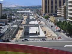
Reno Retrac project

Reno, Nevada railroad tunnelization
Layman is quite correct in pointing out the extra land use efficiencies of the potential of tunnelization for increased capacity within a given corridor.

Fort Washington Way, Cincinnati, Ohio
8 lane depressed highway with parallel underground transitway,
with segments of highway designed to be subsequently covered


He over looks its potential though as a linear park that would re-knit D.C. NE, and which could be fronted in some areas with new development.

I wrote about my more multi-model proposal for tunnelizing this Washington D.C. transportation corridor in my September 8, 2007 Trip Within The Beltway article
"A Washington, D.C. 'Big Dig'"

(excerpt)

- construct a WMATA Red Line/B&O Metropolitan Branch multi-model transportation tunnel lowering the existing railroads with additional capacity, with a new underground highway from New York Avenue northwards with a split at New Hampshire Avenue for a PEPCO continuation in Maryland to I-95, with the railway/highway tunnel continuing north, northwesterly to the Capital Beltway, with downtown Silver Spring and Takoma heavy rail in a new bored tunnel, and with the Red Line partially in cut and cover tunnel and partially along existing surface segments, notably the historic art deco George Avenue overpass.

This serves as the foundation of a new landscaped lid that would extend southwards towards and architecturally integrated with the back side of Union Station, and extending northerly through the Brookland/Catholic University of America and Takoma areas: the Grand Arc Mall Tunnel.


Grand Arc Mall Tunnel at the Takoma Town Sqaure

Saturday, November 10, 2007

WMATA Takoma Station Transportation Treason and Criminal Malfeasance

Train wreck in Washington, D.C. SE, one day after WMATA's 5-0 unanimous (and near discussion-free) decision to continue to chock the North Central Red Line corridor, underscores subversion of evacuation corridor preservation in the name of providing "transit friendly"development or a "new urbanism" better descried as a "new medievalism."

Go to Takoma Station today and look at the proximity of the "Cedar Crossing" and "Elevation 314" residential projects built after 2001 (and after I took these photos), and envision such a derailment. Also recall that two previous derailments along that RR corridor in 1976 and 1996 had greater setbacks between the RR and anyone's home, respectively Blair Road and a parking lot, giving at least 50 feet. At least one wing of Cedar Crossing, and most of Elevation 314 fall within such a derailment footprint.

Where's the U.S. Department of Transportation on this potential safety risk?

Where's the U.S. Department of Homeland Security on evacuation corridor preservation?

Interesting how such decisions are usually unanimous with little or no debate.

Railcars Fall From Bridge into Anacostia River- The Washington Post Nov 10
Metro Board Approves Project at Takoma Station- The Washington Post Nov 9