Cancelling All The Other D.C. Freeways:
the Barney Circle Project and the earlier East Leg
the Barney Circle Project and the earlier East Leg
 11 Street Bridges (new replacement- construction started late 2009)
This area’s previous project was the Barney Circle Connector, proposed in 1982-83 to essentially continue the I-695 SE Freeway to a split to a parkway not allowing commercial traffic to RFK East Capital Street, and a straight ahead continuation of the mainline freeway upon a new bridge crossing the Anacostia River to the existing 295 freeway to and from the east. Initially each of these was to have 2 lanes per direction, feeding into the 4 lane per direction SE Freeway; however this was soon downsized with the parkway having a single lane per direction.

Illustration: Barney Circle Connector
It succumbed to a law suit alleging environmental grounds, and had its political death with a 1996 D.C. City Council rejection of its initial construction contract. Although promoted by the D.C. government under a Mayor Marion Barry who had risen to political prominence with the anti-freeway organization ECTC – the Emergency Committee on the Transportation Crisis – the project towards the end was not supported by U.S. NCPC.
Illustrations: BCC
The preceding plan was the East Leg of the Inner Loop as routed towards RFK Stadium.
Illustrations: East Leg 1967
The original plan for the East Leg along 11th Street.
Illustrations: East Leg 1955
Illustrations: BCC
The preceding plan was the East Leg of the Inner Loop as routed towards RFK Stadium.
Illustrations: East Leg 1967
The original plan for the East Leg along 11th Street.
Illustrations: East Leg 1955
 Illustration: 1961 East Leg ideas
Yes, the 11th Street Bridges were actually initially meant as a link in a longer north-south route.
 Illustration: 1959 Mass Transportation Plan
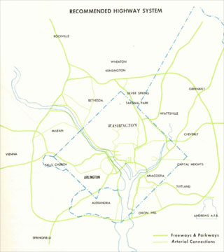
As per both the 1959 Mass Transportation Plan, and the initial I-95 Northeastern Freeway engineering study report released in 1960, this 11th Street corridor would have linked directly with I-95.
The East Leg was to be I-295, with I-95 routed via the north south Center Leg to the SW Freeway.
Under all of these plans with an East Leg, the traffic burden was to be spread with north-south traffic upon a north-south route within northern Washington, D.C. While the 1959 Mass Transportation Plan had three separate northern radial freeways, the November 1, 1962 Kennedy Administration report proposed a single 2 into 1 “Y” route B&O railroad aligned North Central Freeway signed as I-70S to the north of the point of its interception via the Fort Drive-Northwest Branch route I-95 Northeastern Freeway.
 JFK 1962 Plan
 1963-1964 Study
A sensible idea for its central location and its existence as the sole north-south railroad industrial corridor, minimizing residential displacement, the B&O Route North Central Freeway would be politically subverted by its initial 1963-64 engineering studies extreme deviation. That study had an upwards of 37 route options either nowhere near the railroad, or partially paralleling it with serious deviations in Takoma Park, Maryland, and in Brookland, NE D.C.; that would understandably inflame opposition, while the subsequent supplementary 1966 study’s more true to the 1962 JFK version, would be sabotaged by various officials refusing to commit to it; they would argue in favor of instead constructing the infamous 1964 version as late as 1968, long enough to stoke the opposition to reverse the support of the D.C. City Council and the U.S. NCPC for the B&O Route North Central Freeway over the 69 houses (reduced by a design revision in 1970 to 34) for its I-95 segment (while approving I-66, Route 50 and I-295 links with segments respectively displacing 148, 600+ and 172 dwellings as per the 1971 plans).
Illustrations: 1971 plans
These plans would have provided replacement housing, perhaps with even greater numbers of dwellings as the size of the buildings shown suggest.
These northern segments of Washington, D.C.’s planned Inner Loop Freeway system, though substantially redesigned to minimize and mitigate impacts, would be ‘de-mapped’ as per the reasons stated byPeter S. Craig:
Quote 1973-76
This period of de-mapping, leading to a cir 1976 decision to rename inside the Beltway I-95 as I-395 with its extension alongside New York Avenue to Maryland Route 50 cancelled a few years later, culminating in I-395’s current northern truncation at New York Avenue and 4th Street with the 1986 opening of I-395’s northernmost segment with the tunnel segment between Massachusetts Avenue and K Street.
In 1996, at about the time that the Barney Circle Connector Project was under serious political attack, the D.C. Office of the Mayor (Marion Barry) released its proposal for an I-395 extension via a tunnel directly beneath New York Avenue- an idea that would displace no buildings and, upon a single level, allow as many as 7 lanes with shoulders, yet nonetheless be offered only with 4, and have a relatively tight transition radii – something to think about for a curved tunnel – essentially wrapping behind the Bibleway Church complex. The 1996 report includes two options regarding its length, a short tunnel option with its eastern portal at Florida Avenue, and a long option with its eastern portal at 6th Street NE. A 1998 revision would extend this long tunnel to Montana Avenue.
Yet later planning would subsequently go in reverse, with D.C. government planning suggesting a tunnel even shorter then the 1996 short option, with the mainline crossing over Florida Avenue, and with USNCPC even endorsing a tunnel shorter then that already in use today by closing I-395’s northernmost tunnel segment hereby truncating I-395 at Massachusetts Avenue.
Quote


