Sunday, December 28, 2008

Who Really Stopped Washington, D.C.'s Freeways

From Zachary Schrag
http://www.washingtonpost.com/wp-srv/liveonline/00/magazine/levey112700.htm

Washington, D.C.: I enjoyed the article, especially the profiles of Booker and Abbott. But let's not forget who really stopped Natcher's attempt to force the city to accept the freeways.

While the ECTC was gathering a few dozen people to march on picket lines and disrupt hearings, Congressman Robert Giaimo of Connecticut was gathering votes in the House of Representatives to release subway funds from Natcher's control. Thanks to his efforts, on Dec. 2, 1971, the full House voted 195 to 174 to release the D.C. share of Metro funds without forcing the city to build the Three Sisters Bridge. Following this defeat, a very rare case of the full House overruling an appropriations subcommittee chairman, Natcher never again seriously threatened Metro. And without that threat, the D.C. government had no reason to build the freeways.

Essentially there were three challenges to the freeways: in the streets by the ECTC, in the courts by Peter Craig (and his pro bono counsel, Roberts Owen), and in Congress by Robert Giaimo. Craig and Owen bought time, and Giaimo stopped Congress's blackmail. The ECTC, however noisy, did relatively little to change the minds of people in power. Radical protest can make a difference, but in this case the real victory was won by people working within the system.

Zachary Schrag
Columbia University


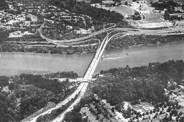
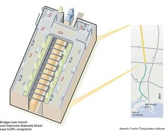
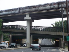
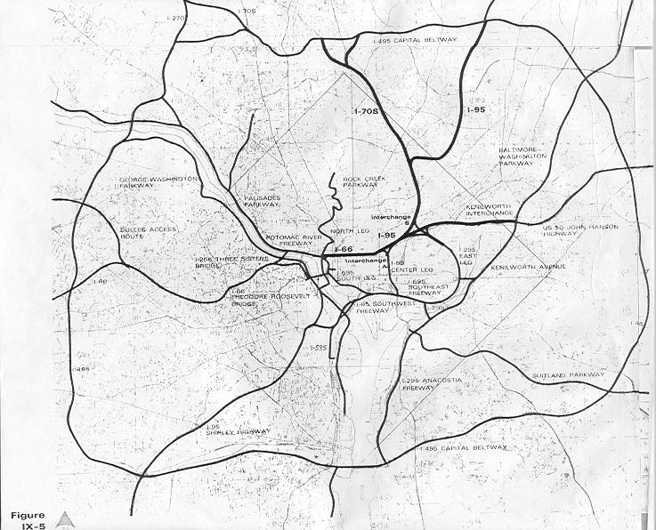
Proposed I-266 Three Sisters Bridge
looking from Virginia to Washington, D.C.
with Georgetown University at upper right.


... Peter Craig, a junior lawyer at the prestigious firm of Covington & Burling. Craig had come to Washington after graduating from Yale Law School in 1953.

In September 1966, following the N.C.P.C. vote, the Committee of 100 resolved to file a law lawsuit against the D.C. government and the N.C.P.C. to block [3 Sisters] bridge construction. Peter Craig, acting for the committee, turned to his former law firm, Covington & Burling. Partner Gerhard Gesell agreed to take the case for a nominal retainer and assigned lawyers Roberts Owen and Gerald Norton to the matter. Owen, the lead counsel, had paid little attention to the highway fight, but he enjoyed suing the government to force it to obey the law.

p 41 and 125 The Great Society Subway by Zachary M. Schrag


   Proposed I-95 B&O North Central Freeway next to Catholic University of America


Covington & Burling


Read About the Committee of 100's opposition to US NCPC's Extending the Legacy

Committee of 100 Ruminations


Frederic Delano 'Family' : U.S. NCPC, Committee of 100, and Covington & Burling


Subverting the North Central Freeway

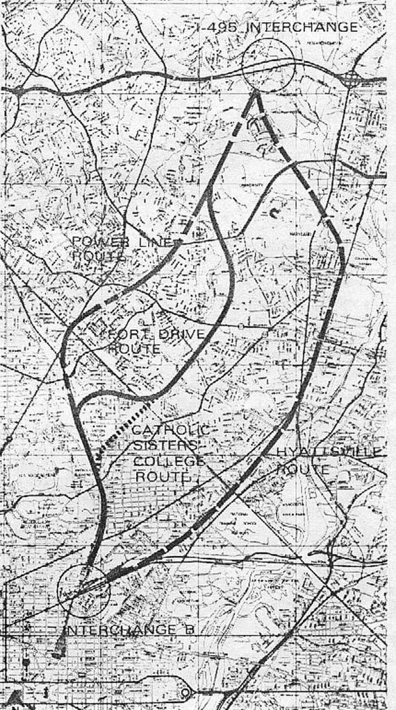
Physical Realities Undermining the North Central Freeway

A Sampling Of Attitudes Towards D.C. I-95

Wednesday, December 17, 2008

Under Selling The B&O Metropolitan Branch

From Richard Layman:

UnderSelling by not mentioning the potential linear park, let alone render that corridor to be more multi-model with an underground North Central Freeway
http://urbanplacesandspaces.blogspot.com/2008/12/transportation-infrastructure-plan-for.html

Crazy Hard and Expensive Proposal

12. If you really want to spend money on infrastructure....

a. put the CSX Metropolitan Branch railroad underground.
b. There would have to be at least two levels of tunnel, for both the railroad -- three tracks -- and for the subway.
c. Make the subway tunnel two levels, or capable of carrying doublestack trains to double the capacity of the red line subway.

This one is so expensive that I won't put it in the priority list, but it could be done and would impact the region's and especially the city's competitive advantage for generations. See the blog entry, "Rethinking the Metropolitan branch railroad and subway tracks in northeast DC" for much more about this.
I have cut and pasted that below:
Rethinking the Metropolitan branch railroad and subway tracks in northeast DC

1. I find it interesting that last week's Current Newspapers announced in an editorial that Mayor Fenty has ordered a cessation of planning to remove the Whitehurst Freeway, something opposed by some but not all of the citizens groups in the Greater Georgetown neighborhood.

2. This is counter to the trend across the country, such as in San Francisco and Milwaukee, not to mention cities like Seoul, where this has already been done. Seattle probably will remove the Alaskan Way Viaduct as well (and there is no question that the Viaduct there cuts off the city from the water).
Seattle's 2-mile-long Alaskan Way Viaduct
AP photo: Seattle's 2-mile-long Alaskan Way Viaduct.

See "15 SECONDS THAT CHANGED SAN FRANCISCO / The sweeping makeover that transformed the city began 15 years ago today with the Loma Prieta earthquake," by John King from the San Francisco Chronicle about removal of the Embarcadero Freeway and the subsequent positive impact.

Also see "Freeway Deconstruction and Urban Regeneration in the United States," a paper from the University of California Transportation Institute and the webpage "Removing Freeways, Restoring Cities."

3. At the Congress for the New Urbanism meeting in Philadelphia there was a session on removing freeways along riverfronts. Michael Lewyn has some notes about the session in his blog. From the entry:

Jeff Tumlin asserted that freeways export real estate value from cities to suburbs; their absence maximizes cities' property value. He used Vancouver as an example of life without freeways: while downtown vehicle trips increased in every other Canadian city since 1995, such trips decreased in Vancouver- even while total trips (including walking/transit/bike trips) increased by 22%!

4. Plus, the City is removing part of the Frederick Douglass Bridge on South Capitol Street, putting more of the roadway at grade, and restoring the street grid in that area. See "Dead End at the Anacostia," subtitled "Two-Month Project Will Complicate Life for 77,000 Douglass Bridge Commuters" from the Washington Post, and ignore the focus on the very short term inconvenience to commuters. Instead focus on how the area will be improved by the reduction of the amount of aerial freeway span and the restoration of the grid.

From the article:

The bridge repairs are being done to extend the life of the span until a new bridge is built. The $27 million project also will allow the new bridge to be built and connected to the street grid without major interruptions, officials said.

About 400 feet of bridge will be eliminated on the northern side of the crossing and 200 feet will be lowered about 10 feet so the span touches down at Potomac Avenue. As part of the project, the stretch of South Capitol Street just north of the bridge will become a tree-lined boulevard.

Click here for the complete Washington Post graphic about the South Capitol Bridge project.

MARC train and subway at Rhode Island Avenue Station

MARC train and subway at Rhode Island Avenue Station

5. In the context of the current underway Brookland Small Area Plan, some of the residents have come up with an alternative suggesting that the railroad and subway tracks and subway station be "depressed" or decked, and the street grid be restored in the area between the two railroad bridge overpasses at Monroe and Michigan Avenues.

(In a conversation last night with a colleague he mentioned that it is not possible from an engineering to depress the railroad tracks for that depth for such a short distance. Railroad locomotive engines like even grades.)
MARC train north of Rhode Island Avenue Station
MARC train north of the Rhode Island Avenue Subway Station

But after reading the piece about the re-configuring of the South Capitol Street bridge, to remove one span and put the street back in and on the grid, I have been thinking that it doesn't reach far enough. The Brookland "alternative proposal" doesn't suggest extending this idea and removing the bridges.
Looking at the Michigan Avenue Bridge, Brookland

Monroe Street bridge, Brookland

Monroe Street bridge and the streetcar
Monroe Street bridge and the streetcar, Joe Testagrose Collection.

6. Extending this idea further, like the Reno Retrac project or the creation of the Alameda Transportation Corridor to connect the Ports of Long Beach and Los Angeles, how about putting the railroad tracks and subway tracks and subway stations below grade, from the Rhode Island Metro Station to perhaps as far as the Silver Spring Metro Station? Definitely to Takoma.
Reno Retrac project
Reno Retrack project. Image by JBR Environmental Consultants.

Alameda Transportation Corridor
Mid-corridor tunnel, Alameda Transportation Corridor.

Both the Reno and Alameda Corridor projects created ditches. (See "The Train Line" for more about the LA project, and the City of Reno website on the Retrac project, including a section on the history of the project.) Instead, I suggest creating the ditch and covering it over, and restoring the street grid.

At Rhode Island Station, the subway tracks are high high above the street, but starting somewhat south, around the big Post Office Complex off Brentwood Road, the tracks could begin to go underground, instead of climbing up very very high. (The tracks start rising just south of the equivalent of T Street NE, around the WMATA maintenance facility.)
Subway bridges over Rhode Island Avenue NE, looking west

Corner of T and 5th Streets NE, adjacent to Sanitary Grocery, near the beginning of the rise of the subway track bridge

Around Franklin Street NE, the tracks go back to grade and a little further they even go underground a bit, where one of the railroad tracks cuts over to the east, and from that point going north for a ways, the railroad tracks bracket the red line subway tracks. Metro tunnel heading north to Brookland around Girard Street at 9th Street NE
Metro tunnel heading north to Brookland around Girard Street at 9th Street NE.

At the very least, it could be done in Brookland, say from Franklin Street up to Ft. Totten. By Franklin the tracks come down to grade or below anyway, from very high up at Rhode Island Station.
Lawrence Street stub at 9th Street NE

Lawrence Street stub at 9th Street NE

7. Another example would be the proposal for a Tysons Corner tunnel, which proposed a two level tunnel, using Spanish technology.
Tysons Tunnel diagram
This idea could be further extended, and a two tunnel system could be created to separate the railroad from the subway.


See this blog's articles on the Grand Arc Mall Tunnel

Monday, November 24, 2008

Eastern SE Freeway Bastardization

Simply converting the eastern portion of the SE Freeway to a boulevard increases vehicular-pedestrian conflict, and is totally unnecessary, as evident from the cross sections in the Middle Anacostia Transportation Study, seen here [warning- PDF] at page 35 "Boulevard Typical Section #2 - Looking East towards Barney Circle".


Evidently the topography favors covering over the existing freeway, with the new boulevard atop; not shown is the idea of covering the RR nor extending the cover towards the Anacostia River with a terrace/staircase, as already done at the Lincoln Memorial. As this involves covering the existing freeway -- IOW no new depressing -- this is a comparatively cheap freeway under-grounding, unlike say this freeway to the west between the 11th Street and 1th Street Bridges.

The idea of covering the segment of this freeway between 14th and 15th Streets SE appeared in this late 1960s illustration seen here.

Continuing this cover westerly requires removing the elevated approaches to the 11th Street Bridges, something that I propose with a replacement with below grade approaches that would conflict with the existing heavy RR, though compatible if converted to vehicular traffic or lighter rail which can tolerate grade changes upwards of 5% whereas heavy RR can only tolerate a 1% grade. As with the highway, this railroad right of way is coverable.

Continuing this cover easterly to Barney Circle would be feasible with allowances for the ramps.

Likewise, the topography allows such a relatively easy under-grounding for this freeway's needed extension to RFK Stadium- East Capitol Street, and is fully compatible with planning for a slow speed waterfront boulevard atop, including the idea of a traffic circle at Massachusetts Avenue SE. Here to the railroad should also be covered.


Only those promoting a mindless ideology against urban freeways -- alas those traditionally in control of the governments -- would rather place all of this vehicular traffic upon the surface waterfront boulevard.

Saturday, November 15, 2008

11th Street Bridge[s] Fiasco, Evacuation Route Ramp Demolition To Come

From the JD site:

Then there's the bridges: Reconstruction of the 11th Street Bridges is scheduled to begin in mid-2009. (The shortlist of firms vying for the design-build contract was announced a few weeks ago.) Whether we actually see heavy equipment moving in mid-2009, or whether this just marks the first part of the design-build project is not quite clear. I was also told that the contract to demolish the flyover ramps to and from RFK could be completed soon, and that demolition would happen not long after the contract is signed.

Plus, the final Environmental Impact Statement for South Capitol Street and the Douglass Bridge is expected in spring 2009; that's when we'll hear which of the four bridge designs has been chosen.

This fatally flawed project -- RFK ramp demolition, eastern SE Freeway boulevardization with traffic lights, and replacement with new elevated ramps -- needs to be stopped and seriously re-planned... as currently proposed the project fails to pass even a laugh test, as so with the controlled opposition that focus only upon the increased public utility of the connection to the Anacostia Freeway.

The Nature of DC Area "E" Organizations

From the Yahoo ICC list:

Re: Md.: Chevy Chase to retain firm to study Purple Line

Posted by: "C. P. Zilliacus" CPZ@OS2BBS.COM cpzilliacus

Fri Nov 14, 2008 6:12 am (PST)

The Town of Chevy Chase Town Council voted unanimously at a Thursday night meeting to hire a law firm on a pro bono basis to analyze a state report on the Purple Line.

The above is curious. If the firm is working for them on a pro bono (free) basis, do they really hire them? I don't know, as I am not a lawyer, and I don' t play one on T.V.

And any Maryland municipality that has the string Chevy Chase in its name is not exactly my idea of a place that needs free legal help anyway.

The council voted to hire Sidley Austin, a Washington, D.C., firm to examine the Alternatives Analysis/Draft Environmental Impact Statement (DEIS) for the Purple Line released by the Maryland Transit Administration last month. The statement analyzed several options for the Purple Line mass transit project, which would connect Bethesda to New Carrollton.

This is even more interesting. Sidley Austin was very involved in efforts to disrupt and delay the DEIS and FEIS for the InterCounty Connector on behalf of Environmental Defense, the Chesapeake Bay Foundation and others. Examples here
<http://www.mwcog. org/uploads/ committee- documents/ vV1eWFc200407261 53649.\pdf> ,
here
<http://maryland. sierraclub. org/Montgomery/ press/ICC_ 122006.htm>
and here
<http://www.arnoldpo rter.com/ resources/ documents/ Audubon-v- DOT.pdf>

Are they a CAVE (citizens against virtually everything) law firm?

Doug Willinger, have you run across this firm in your research into anti-highway activities elsewhere?

My reply:

I have not researched Sidley Austin, though in checking out their Wikipedia entry I found this:
Famous alumni

* President-elect Barack Obama was a summer associate in the Chicago office, but never joined the firm as a full-time associate. He met his wife, Michelle Obama (who was an associate at Sidley Austin at the time), while he was a summer associate at the firm. [8]

http://en.wikipedia.org/wiki/Sidley_Austin
I do not have time right now to continue this research, but have already researched that power house Pennsylvania Avenue law firm Covington and Burling and have turned up much (C&B just happens to be involved with practically everything I have blogged about.

http://continuingcounterreformation.blogspot.com/2008/08/college-frats-as-satanic-romish-masonry.html

(In particular check out the links within the above article regarding Transport Network Subversion)

I suggest similar lines of research upon Sidley Austin, including its founders and their fraternal memberships.

FH Covington's frat happens to pop up in a new book about Illuminati government control discussed here.

http://continuingcounterreformation.blogspot.com/2008/11/explaining-people-like-fdr-etc.html

quote:
"Albert C Stevens (the respected historian) also makes this interesting connection between the Masonic Kappa Sigma society, founded in 1867 at the University of Virginia, and Skull and Bones. On page 355, Stevens states, “The badge [of Kappa Sigma] is an inverted crescent of gold, attached to and below which, by four of its points, is a five-pointed star [the pentagram] with the letters Kappa Sigma in its center…. At the top, on the crescent, a skull and bones are engraved; at the left, the crossed keys [a symbol of the pope’s power], and at the right, crossed swords.”[17] Is this all mere coincidence?"
I highly doubt that that Chevy Chase Country Club is the only example of a disproportionate influence of entities who control a particular piece of real estate.

Note for instance CUA, as well as that "Order of the Eastern Star" property that connects the I-95 PEPCO-B&O Routes, which just happens to be the entity which hosts the Committee of 100 Christmas Party (an organization that is notoriously anti grade separated highways).

http://cos-mobile.blogspot.com/2008/07/homeland-security-goal-would-be-better.html
http://wwwsouthcapitolstreet.blogspot.com/2008/09/appearances-of-power-ruminations.html

I suspect this is just the tip of the proverbial iceberg.

Friday, October 31, 2008

ECTC VC Marion Barry For Private Use Eminent Domain


Marion Barry, now a member of the Washington, D.C. City Council, and the Vice Chairman of the 1960s-70s organization, the 'Emergency Committee on the Transportation Crisis' (ECTC) which strictly opposed grade separated highways providing a vehicular alternative to surface streets, FAVORS the use of eminent domain for PRIVATE use, to the east of the Anacostia River.

http://anacostianow.blogspot.com/2008/10/eminent-domain.html


It was the ECTC which conducted protests over the demolition of 69 dwellings (reduced to 34 in 1970) in western Brookland, D.C. near the railroad tracks that run alongside Catholic University of America, for PUBLIC use eminent domain for the B&O Route low level North Central Freeway, which was to be the sole north-south northern radial such facility within Washington, D.C.

Thursday, October 02, 2008

Union Station Centennial

Grand Arc Headpiece

http://urbanplacesandspaces.blogspot.com/2008/10/union-station-celebrates-its-100th.html

From 10 am to 4 pm on Saturday and Sunday, Amtrak will be displaying historic rail cars. Union Station Redevelopment Corporation will be displaying historic photos.

AP has a story, "Washington's Union Station celebrates 100 years."

Don't forget the in-process dissertation about Union Station by Bill Wright. He's a great writer. Check out his website.

Tuesday, September 30, 2008

Congress for 'New' Urbanism Seeks Eliminating SE Freeway and 11th Street Bridge

Advocates Removing Evacuation Route, if not increase vehicular - pedestrian conflict!
http://www.cnu.org/highways/freewayswithoutfutures

10. 11th Street Bridges and the Southeast Freeway, Washington D.C.

The Southeast Freeway is a 1.39-mile stretch of freeway running through Washington D.C. built in the late 1960s. It connects Interstate 395 to Interstate 295 at the 11th Street Bridges and was prevented from continuing west due to local opposition at the time. To address congestion and traffic routing problems at the interchange connecting the Southeast/Southwest Freeway and the Anacostia Freeway (I-295) over the Anacostia River, the Federal Highway Administration (FHWA) began investigating how to reconstruct and reconfigure the interchange at the 11th Street Bridges.

The Concerned Citizens of Eastern Washington, the Capitol Hill Restoration Society, some of whom were involved with the freeway revolt in the 1960s, began investigating the FHWA's preferred alternative in the Final Environmental Impact Assessment. Working with the transportation engineering firm Smart Mobility, Inc., the Capitol Hill Restoration Society discovered that, while the DC Department of Transportation states that there will not be an increase in capacity, the “preferred alternative … will result in a 50% increase of freeway capacity into central DC, even though this is contrary to the DC Comprehensive Plan.” This project has renewed discussions about improving surface-street and pedestrian connections in the near southeastern section of the district by removing the Southeast Freeway -- what the DC Office of Planning refers to as a “formidable psychological barrier.”

Actually the highway was not prevented from extending to the west, as that was built as the SW Freeway. Rather it was prevented from extending to the east and the north by canceling the East Leg, and afterwards via canceling the Barney Circle connector.


Monday, August 11, 2008

Washington Gateway Chock

New Demolition Special to Complicate I-395 Tunnel Extension; builds upon remaining sliver of land adjacent to New York Avenue, forcing tunnel directly beneath existing Avenue as it rises to overpass railroad


Number "17"

Project is in immediate need of cancellation, for blocking the remaining sliver of land allowing construction of the I-395 tunnel extension alongside New York Avenue - particularly along the highly useful O Street axis.

Project chocks the I-395 extension whether to the (eastern) New York Avenue corridor or the (northern) B&O corridor.

Project also conflicts with lowering the B&O railroad and the idea of covering said railroad as done via the Grand Arc.

Project testifies to the sheer incompetence of D.C. planning and the degree the authorities are beholden to medievalists that would chock publicly valuable evacuation route, disregarding civil defense (while nonetheless embracing 1984-esque domestic surveillance).

Is scheduled to start construction autumn 2008.

I-395 Tunnel Extension Superior Option

MRP Reality
MRP Reality- Washington 'Gateway' Project

Monday, August 04, 2008

Evacuation Route To Be Demolished This Summer!!

U.S. DOT approves demolition of RFK Stadium Access Ramps
& Highway


From Jacqueline Dupree:
http://www.jdland.com/dc/index.cfm?id=2641

The FAQ mentions that the existing flyover ramps to and from RFK (the ones that head east over M Street) are supposed to be demolished "this summer", but I've been unable to get any details from DDOT as to whether that's still happening. I'm also not sure whether that's part of the bigger plan (not technically part of the bridge replacement project) to completely do away with the current below-grade freeway to Pennsylvania Avenue and replace it with "Southeast Freeway Boulevard", running at-grade from 11th Street eastward. (Read the EIS for more on that.)
How much is it going to cost? The ROD says that a cost review meeting in December "indicated that the estimate was consistent with an 80th percentile probability that the year-of-expenditure project cost would not exceed 465 million dollars." Those of you well versed in bureaucracy-speak can translate that as necessary.
http://www.11thstreetbridgeseis.com/reports.asp?DocGroupID=10033
http://www.11thstreetbridgeseis.com/

Thursday, July 24, 2008

Media Talking Head Bob Novak Hits Pedestrian With His Black Corvette

Apparantly Bob Novak is a man who drives to make time, to say the least.

Particularly when driving within Washington, D.C.

In a Black Corvette.

So, can anyone point to what this man has ever said publically on any of his talk shows about the government's 'inability' to construct a continuous freeway system?

With all of the talk about the changed reality after 911, what has Novak or any of the other Washington, D.C. media talking heads said about evacuation routes?

Surely he's aware of how I-395 just dumps out onto New York Avenue, etc.

http://www.huffingtonpost.com/2008/07/23/robert-novak-taken-into-p_n_114510.html

Wednesday, July 23, 2008

Takoma D.C. Tranport Chock Developer Chocked SW Freeway

An Epidemic of Corridor Chocks
right within the Nation's Capital City
Washington, D.C.


The developer that is pushing the development project at the Takoma WMATA Station is the same developer that irresponsibly chocked the SW Freeway corridor with the row of 28 townhouses at the northern edge of the Capital Square townhouse project, Eakin Youngentob.

As I wrote in my original "Highways And Communities" web site:

Eakin-Youngentob "Capital Square" townhouses, on land plot between 6th, 7th, G Street SW and the SW Freeway, with row of 28 townhouses a mere 16 1/2 feet from SW Freeway retaining wall, one block south of the U.S. Department of Housing and Urban Development. This 16 1/5 foot setback is significently less then that of all of the other buildings along the southern side of the SW Freeway, which have 70-90 fete of setback.

This makes it more difficult and expensive to construct new retaining wall for tunnel roof (as the existing walls would not be likely to be so designed), hence keeping the existing SW Freeway in a configuration that divides DC SW - hence contrary to long term NCPC planning for the removal of the mass of elevated highways and railways that now cross over South Capital Street.

This also makes it more difficult and expensive to improve safety and decrease conjestion and pollution with mitigating the SW Freeway bottleneck southwards and westerly of the Center Leg -- hence more likely remaining a traffic bottleneck with ripple effects well into Virginia.

http://web.archive.org/web/20060207152135/www.highwaysandcommunities.com/Planning_Errors_D.C._Real_Estate_Development_built_ALERT.htm

WMATA's awarding this developer underscores a blatant disregard for long term transportation corridor planning.

If numbers of dwelling were the overriding favor why was the Capital Square project built as townhouses rather than something more substantial with greater numbers of such along with the setback from the SW Freeway.


Thursday, July 17, 2008

A New I-395 Gateway- If It's Coordinated With New Development

A big "if" ...

New 14th Street Bridges
with tunneled vehicular connections to 14th Street and I-395


New I-395 tunnel segment to come with replacement of the existing 14th Street Bridges. Employs virtually the same alignment that I have proposed, though with a somewhat sharper curved transition to the existing SW Freeway then necessary.

Idea of revised ramp connections to 9th Street appears to require demolition of existing building at L'Enfant Plaza, which is consistent with desire to remove the "brutalist" 1960s-70s era architecture, and which would likely be eased by removal of the row of 28 townhouses that were irresponsibly placed only 16 1/2 feet from the existing SW Freeway retaining wall in 1999-2000 as the northern edge of the "Capital Square" residential project by EYI Associates between 0th and 7th Streets. With this occurring within sight of the headquarters of the U.S. Department of Housing and Urban Development and the U.S. Department of Transportation, why did not these agencies object?

Beyond the sharper curved transition to the existing SW Freeway alignment, this NCPC plan differs from my conceptualization by lacking a split to a supplemental I-395 tunnel beneath G Street SW to ease constructibility (e.g. routing traffic- particularly during constructing the new connection to the existing SE Freeway alignment at 7th Street SW), while permanently providing additional capacity with a gentler curved connection to the north-south Center Leg (3rd Street Tunnel): easing a traffic bottleneck that customarily extends into Virginia.

The surface treatment differs with its lack of an extension of G Street SW towards the Jefferson Memorial providing some additional landfill to more integrate the area, and of a traffic circle at the 14th Street location of the I-395 tunnel portal. As I envision it, this new bridge/tunnel segment would be located on the extended axis of Louisiana Avenue.

This proposal also includes a new more literal "14th Street" Bridge -- together with the above mentioned new I-395 bridge -- crossing the Potomac River, with both having tunneled segment respectively to 14h Street and the SW Freeway. It also includes burying the railroad, preserving the existing railroad corridor but at a lower elevation accommodating a newly restored Maryland Avenue.


New development proposal by Hoffman-Struever Waterfront LLC

http://www.swdcwaterfront.com/

Yet will the authorities be able to control themselves to preserve the necessary easement for the new segment of tunneled I-395?

Or shall they place buildings directly in the path?

Boondoggles as "Capital Square", the "Golden Rule" apartment house, and a bit of the rush of development along the South Capitol Street corridor suggest the latter.

Final Approval for DC financing of Waterfront passed- SWDC Blog

A busy day for NCPC- Greater Greater Washington

National Capital Framework Plan- Continuing The Legacy


Sunday, July 06, 2008

Parochialist Planning Sells Out Valuably Useful D.C. North Central Transport Corridor

- Chocks Washington, D.C.'s sole norther north-south transport corridor;
- Sells out public need for a bit more real estate development;
- A
ltogether disregards post 911 security/evacuation route in a general planning that has disregarded civil defense
- Promoted by the government and Catholic University of America

http://www.metbranchtrail.com/Documents/5DraftChapter5.pdf
(warning PDF!)

http://wwwtripwithinthebeltway.blogspot.com/2008/05/cuabrookland-transport-corridor-chock.html

Note the placement of the North Central corridor about midway between the eastern portion of the Capital Beltway and the Potomac River. Is shown here with the I-95 Northeastern Freeway via the Northwest Branch Park route.


Sunday, June 29, 2008

Parochialist Threat To Truncate I-395 at Massachusetts Avenue

http://www.wjla.com/news/stories/0608/530988_video.html?ref=newsstory

D.C. government to seek closing useful underground highway segment to screw DC neighborhoods and the general public.

Proposal would reroute traffic through Massachusetts intersection and up New Jersey Avenue to New York Avenue in the hope that more motorists would just go elsewhere.

No mention of post 911 evacuation route concerns- a topic that the government shows zero interest (along with civil defense), instead only interested in domestic surveillance to subvert the 1st amendment.

According to WTOP:

(excerpt)
Interesting 'logic': close a road because it benefits the many rather then the few.

This sounds like another example of white is black and black is white 'thinking' that permeates our rouge government into subverting the public interest.

This sort of neo feudalism/new medievalism is being promoted through not only the DC government but also the federal- to wit the US National Capitol Planning Commission. It published a report in 2006 [warning PDF] which states:

The consultants offered the following observations and recommendations to address the heavy through-traffic using New York Avenue:
The D.C. street network exists to serve District residents and neighborhoods, first, and those who work in the District, second. Give much less priority to accommodating regional (interstate) traffic. (Decker, Morrison, Peloquin, Slade, Stull)
That latter part has lead to the current disastrous results.
Provide multi-modal transportation in the New York Avenue corridor by accommodating pedestrians, bicycles, transit, railroad, and automobiles. (Morrison, Slade)
Better accomplished with a parallel tunnel-highway then pushing the traffic onto New Jersey Avenue.
Focus on moving people––not cars. Encourage a bias against the automobile. (Decker, Morrison, Slade)
This gets regurgitated again and again with no thought to the reality that automobiles accommodate people rather then drive themselves with artificial intelligence.
Removal of the current regional through-traffic volume on the corridor would create opportunities for mixed-use development in this District. (Decker, Morrison, Peloquin, Slade, Stull)
And without a new parallel tunnel-highway create more traffic congestion in complete disregard to post 911 concerns about evacuation routes.
To discourage use of New York Avenue/I-395 for regional through traffic:
(Decker, Slade)
IOW- make the many spend more time and fuel on stop and start surface streets or the longer route of around the city. Will their study even list this?
Consider tolls or congestion pricing. (Decker, Slade)
That could be reasonable to pay for the new highways
Consider truncating I-395 at Massachusetts Avenue. (Decker)
Attempt to push the burden away while greatly increasing traffic on New Jersey Avenue between Massachusetts and New York Avenue, and conflict with the elderly pedestrian inhabitants of the misplaced Bibleway Golden Rule apartment complex and their nearest grocery store.

Me thinks that the people behind this need to be fired, starting with these overpriced/overrated consultants.

DDOT suggests cutting 395 to Mass Ave- Greater Greater Washington