The U.S. Government ought to be ashamed of itself-
while it permits 'good old boy' style politics in permitting contemptuously placed real estate development locking in obsolete infrastructure and preventing improvements,
Spain's King Juan Carlos must be laughing at Washington D.C. - see Madrid's M-30 Project AUTOVÍA M-30 TRAMO OESTE Y TÚNEL
Tuesday, February 28, 2012
Madrid Over Washington, D.C.
Sunday, February 26, 2012
Preserving Elevated I-395
New SW Development to preserve existing SW Freeway
blocking implementation of U.S. NCPC 2008 proposal for an I-395 Washington Channel Tunnel,
more of the 'trendiness' of real estate development so close to existing transportation corridors so as to lock in in adequate and divisive 1950s freeway design, and of the Federal government's abdication of its Constitution prerogative of eminent domain
 Building too close to the SW Freeway thus thwarting mitigation efforts as U.S. National Capital Planning Commission's I-395 Washington Chanel Tunnel
http://www.swdcwaterfront.com/about/Presentation_Community_Forum.pdf
Includes new building on the Banneker Knoll covering the SW Freeway, locking in its inadequate width and its elevated Washington Channel Bridge crossing, effectively blocking the US National Capital Planning Commission's 2008 I-395 Washington Channel Tunnel
http://wwwtripwithinthebeltway.blogspot.com/2008/07/new-i-395-gateway-if-its-coordinated.html
 U.S. National Capital Planning Commission's I-395 Washington Channel Tunnel, mitigates noose of roadways near the Jefferson Memorial; accommodates real estate development built of course afterwards
NOW is the time for employing that Constitutionally mandated power of eminent domain for public use, notably roads, for securing the space for constructing the Washington Channel Tunnel. Likewise for the needed improvement of the existing land portion of the SW Freeway establishing the space for beginning construction of the new submerged underground replacement, including removing the row of 28 'Capital Square' townhouses built a mere 16 1/2 feet from the Freeway's retaining walls, rather than let new real estate development prematurely as the reason or excuse to do preserve the existing Freeway's form.
The Federal government incapable of intervening to promote its own NCPC's recommendations, thus locking in the existing obsolete SW Freeway design, within site of the U.S. Departments of Housing & Urban Development and the Department of Transportation is something to make people further ponder and question the political dynamics that govern the government.
Friday, February 24, 2012
Tiber Creek Transition to Be Covered by "Washington Gateway" Project
While Rail-Road wall remains uncovered
"Washington Gateway" Demolition Special project to Cover Over Best Spot for Transitioning a restored resurfaced Tiber Creek from the Grand Arc via a new waterfall
http://wwwtripwithinthebeltway.blogspot.com/2008/08/washington-gateway-chock_11.html
Preliminary ground work reportedly underway (GGW- Feb 23, 2012).


 Creek was buried by the construction of the B&O Metropolitan Branch project that included Washington, D.C.'s Union Station, which has since marked the boundary of monumental core.
Wednesday, February 08, 2012
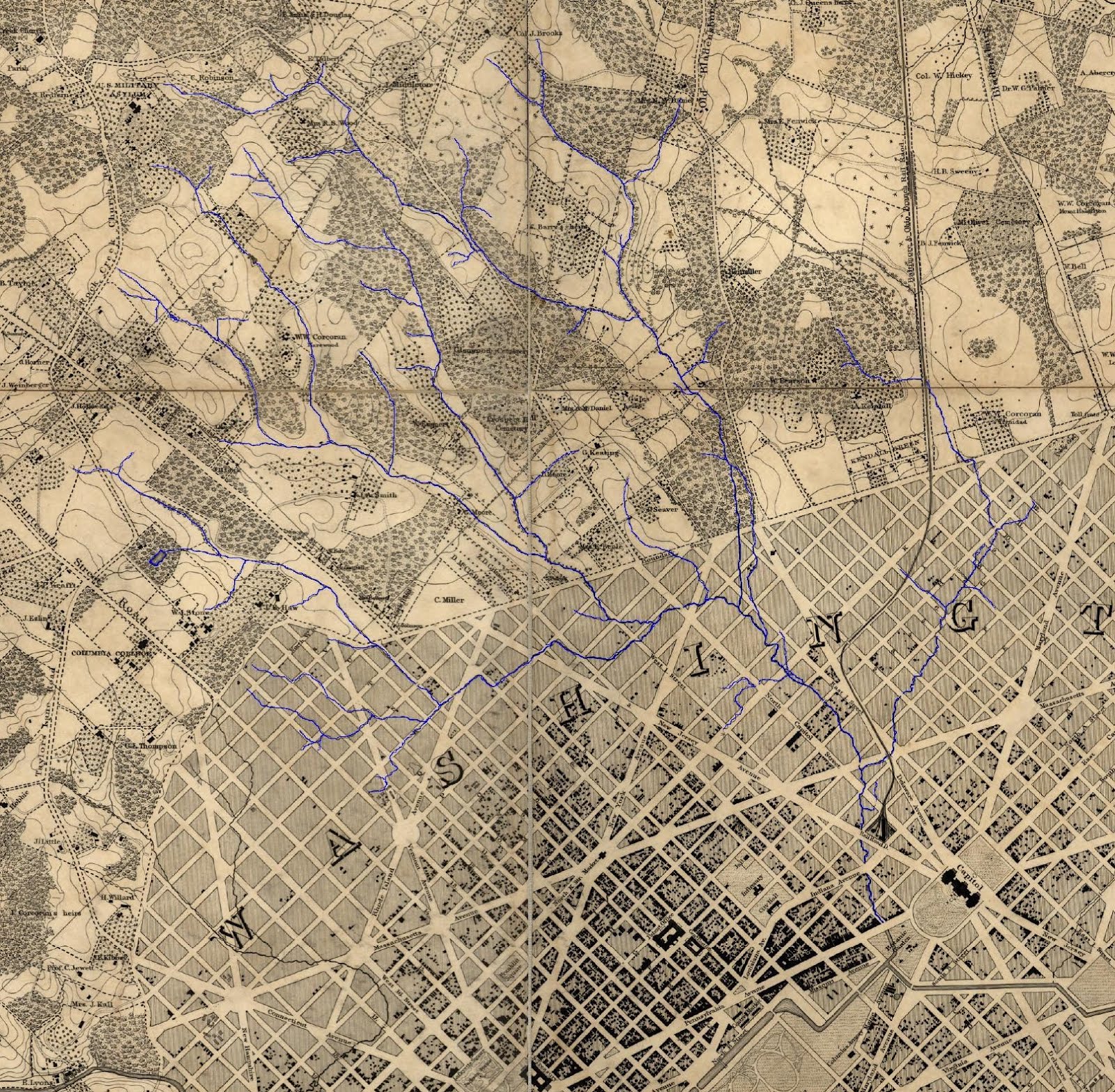
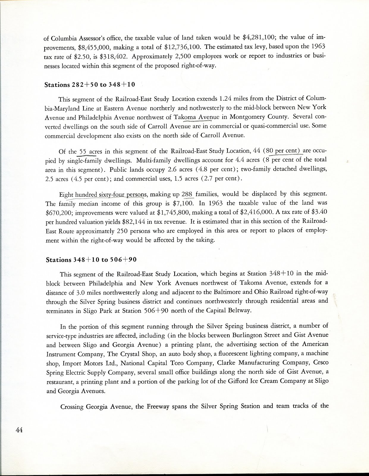
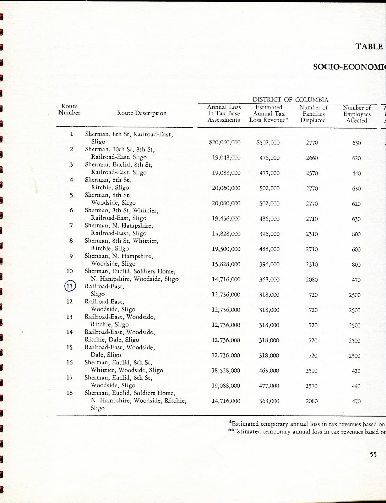
1964 North Central Freeway Report GUIDE

OVERVIEW
http://wwwtripwithinthebeltway.blogspot.com/2006/11/1963-64-north-central-freeway-study.html
REPORT - PLATES
http://wwwtripwithinthebeltway.blogspot.com/2008/05/1964-north-central-freeway-report-je.html
REPORT - FULL TEXT & CHARTS (Complete)
http://wwwtripwithinthebeltway.blogspot.com/2012/02/october-1964-north-central-freeway.html
REPORT - ON THE B&O ROUTE
'PIN POINT THE B&O CORRIDOR ONLY AFTERWARDS'
http://wwwtripwithinthebeltway.blogspot.com/2012/01/pin-point-b-rr-in-dc-only-after-more.html
October 30, 1964
ENGINEERING FEASIBILITY REPORT
NORTH CENTRAL FREEWAY
DISTRICT OF COLUMBIA and MONTGOMERY AND PRINCE GEORGES COUNTIES MARYLAND
Prepared for the
DISTRICT OF COLUMBIA DEPARTMENT OF HIGHWAYS AND TRAFFIC and
STATES ROAD COMMISSION OF MARYLAND
In cooperation with the
U.S. DEPARTMENT OF COMMERCE, BUREAU OF PUBLIC ROADS
J.E. GREINER COMPANY
Consulting Engineers
OCTOBER, 1964
This red cover contains two 11' x 17' booklets- "Plates, Plans & Profiles" and "Report".
This is complete scans of the latter (on an 8'x 12' scanner- un-stitched)
This is complete scans of the latter (on an 8'x 12' scanner- un-stitched)


Subscribe to:
Posts (Atom)


