Showing posts with label Washington D.C. Freeways. Show all posts

Saturday, January 03, 2015

The Washington City Paper's Obliviousness To The War On Freeways


excerpt from an April 19 2013 article in The City Paper by Aaron Wiener:
 "There is No War on Cars"
http://www.washingtoncitypaper.com/articles/44173/there-is-no-war-on-cars/
This was the era when slums were condemned and razed in the name of urban renewal, when neighborhoods in Southwest were wiped out to build Brutalist federal office buildings and the quadrant’s eponymous freeway. The push to replace houses with highways amounted to a declaration of war on the District—and particularly the areas around downtown that were home mostly to minorities and the elderly—by “the whole interstate highway lobby, which were basically the oil companies and the aggregate companies and people that built the highways and that sort of thing, car companies, everybody like that,” says Boasberg. Fortunately, residents and preservationists managed to stave off much of the damage by successfully protesting proposed freeways like the Inner Loop encircling the White House in a half-mile radius, the 10-lane North Central Freeway running from Union Station through Brookland to Silver Spring, and the Three Sisters Bridge spanning the Potomac near Georgetown, saving numerous residential areas and parks from destruction.
In the 1980s, with the most aggressive freeway plans shelved and Metro operating with additional construction well underway, the city made modest efforts to restore some high-speed roads to neighborhood-friendly uses. No sheriffs threatened to shoot out anyone’s wheels, but reactions occasionally did get violent. Tom Downs, who led the District Department of Transportation from 1981 to 1983 and now chairs the Metro board, recalls a particularly extreme response to his efforts to remove reversible lanes, which allowed for speedier commutes, from Reno Road NW.

The above is a total blur of the history that ignores the design evolution -- from the clearing of all new swaths demolishing 1000s of dwellings vs the later use of cut and cover tunnels largely with existing corridors -- as well as the politics.

By 1980- ALL the freeway plans were shelved with the one remaining incomplete- the northern tunnel segment of the Center Leg - initially constructed from 1975 to 1978 - left with nothing appropriate to connect to was still un-opened.  And would not be so until a 1983-1986 finishing project to simply have I-395 be entirely intercepted by a surface street, New York Avenue, and be equipped with added walls cutting its 4 lanes in each direction in half.

The plans canceled during the 1970s were vastly different than those from the 1950s and into the 1960s.  Vastly different that the 1955 Inner Loop report that produced the basic design used for the SW and western portion of the SE Freeway.


I-66 North Leg Proposal: 1959


I-66 North Leg Tunnel Under K Street Proposal: 1971


See and compare the plans from 1955 and later:

1955 Inner Loop Engineering Report:
http://wwwtripwithinthebeltway.blogspot.com/2007/01/blog-post.html

1955-1962:
http://wwwtripwithinthebeltway.blogspot.com/2006/12/1950-62-plans.html

Compare the above with the later Inner Loop plans:

1966-1971: North Leg of the Inner Loop
http://wwwtripwithinthebeltway.blogspot.com/2007/03/i-66-north-leg-west-k-street-tunnel.html

1967-1971: East Leg of the Inner Loop
http://wwwtripwithinthebeltway.blogspot.com/2007/03/i-295-east-leg-to-east-capitol-street_17.html

1962-1971 B&O Red Line I-95; see the planning shenanigans that happened with the main northern freeway along the railroad next to Catholic University of America proposed by JFK about one year prior to his assassination:
http://wwwtripwithinthebeltway.blogspot.com/2012/01/crafted-controversy-scuttling-of-jfks-b.html

As refined by 1971, the bulk of the building demolitions were in the middle area of the North Leg, a bit west and to the east of where the Center Leg ands at the intersections of 4th Street, New Jersey and New York Avenues- some 148 and 600+.


The anti freeway protest cry had been "No White man's Roads Through Black Man's Homes."

Yet the bulk of the demonstrations were for 69 reduced by 1970 to 34 dwellings at the western area of Brookland near Catholic University of America; and at the area next to Georgetown University.


 I-95 B&O North Central Freeway next to Catholic University of America


 I-266 3 Sisters Bridge next to Georgetown University

http://wwwtripwithinthebeltway.blogspot.com/2009/10/ectc-paid-to-riot-via-covington-burling.html
See the reasons given for the 1970s 'de-mappings":
http://wwwtripwithinthebeltway.blogspot.com/2009/04/doctrinaire-anti-new-highways-position.html
http://wwwtripwithinthebeltway.blogspot.com/2007/02/doctrinaire-anti-new-highways-position.html


Dear readers of The City Paper: see a concise history of the Washington, D.C. Highway Planning Historic Trends:
http://wwwtripwithinthebeltway.blogspot.com/2014/09/getting-over.html

Also see the excellent site of Scott Kozel: Roads to the Future:
http://www.roadstothefuture.com/DC_Interstate_Fwy.html

Related A Trip Within the Beltway articles:
http://wwwtripwithinthebeltway.blogspot.com/2013/05/washington-dcs-war-on-freeways-war-on.html
http://wwwtripwithinthebeltway.blogspot.com/2013/06/washington-dc-war-on-drivers-war-on.html


Addendum: January 6, 2015:

The City Paper appears to be willfully misleading people with their blurred and overly simplistic reporting of the freeway planning history:


"The City Paper article grossly blurs the history of the freeway planning and the war on the freeways and the less affluent

http://wwwtripwithinthebeltway.blogspot.com/2015/01/the-washington-city-papers.html
http://wwwtripwithinthebeltway.blogspot.com/2014/09/getting-over.html
Read up on the history at A Trip Within the Beltway"

"Your comment has been flagged for spam or trolling and will be reviewed by a moderator. If you feel that this is an error, please leave a comment with your name and email address."
But I did include my name and email address.

Note that I get the same result when re-submitting the comment without the urls:


And at least one of the approved comments has an html tag:


The City Paper is practicing censorship, as I submitted this comment days ago to no avail.

I can only conclude that The City Paper knows that it misrepresents the history- doing so for the sake of medievalists- who in centuries of running Europe opposed free speech.


Sunday, September 28, 2014

Getting Over Upon Society at Large and the Less Affluent


About the wealthiest unjustly placing the burden elsewhere


 http://wwwtripwithinthebeltway.blogspot.com/2013/08/washington-dc-war-on-people-shuns-east.html

 http://wwwtripwithinthebeltway.blogspot.com/2014/09/a-se-freeway-plan-benifiting-greatest.html
The Hill East stance against a Massachusetts Avenue Bridge and an extension of the SE Freeway along the west side of the Anacostia River that could serve as a traffic alternative to the obsolete Anacostia Freeway along that river’s east side, is a textbook example of a wealthier area getting over upon a less affluent area to the east.

That freeway – the Anacostia Freeway – the sole continuous route Washington DC freeway, was constructed between 1956 and 1964.  It may have displaced few residences.  But it was built with an almost entirely surface and elevated design that locally separates the neighborhoods to the east- notably Washington, D.C.’s least affluent from the waterfront, with little more than some lip service to portions of it being rebuilt in a tunnel configuration as local mitigation.

Such is alas but a link in a chain of a series of instances of wealthier areas within Washington DC getting over upon less affluent areas.

- The Failure to build the Northwest Freeway entering Washington, D.C. along the Wisconsin Avenue corridor.

This would have been a freeway ideally along the Wisconsin Avenue corridor in Bethesda MD and upper NW to the area of Tenley Circle, before entering a tunnel- necessary for the topographical transition to downtown.

The NW Freeway appears in planning documents during the latter 1950s, including an engineering study in 1957.  That study had two main options, one along Canal Road, the other along Wisconsin Avenue to Tenley Circle and continuing south via the Glover Archibald Park corridor.  Each had variants directly to the Whitehurst Freeway or an inland option along the Whitehaven Park corridor.


1957 NW Freeway Report

http://wwwtripwithinthebeltway.blogspot.com/2011/03/1957-northwest-freeway.html

The Wisconsin Avenue corridor option had the best serviceability for that existing commercial corridor, being located roughly midway between Canal Road and Rock Creek Park, and connecting directly with the eastern spur of I-70S (I-270), taking advantage of the wide corridor by Medical Center.   As that corridor was to be extensively redeveloped to accommodate WMATA red line induced transit oriented development, it would have fit largely if not primarily within the footprint of this redevelopment, particularly in downtown Bethesda and Friendship Heights.

 1965 local downtown Bethesda, MD
NW Freeway route proposal

As envisioned by 1957-1959 planning, the NW Freeway would extend southward from the MD-DC line to a set of cut and cover tunnel underpasses beneath Tenley Circle with the possibility of an underground connection with an east-west intermediate 'Fort Drive' Beltway segment along Nebraska Avenue.   According to the 1957 study, that segment from the MD-DC line to Tenley Circle area would have displaced 74 residences.

A failure to overturn an agreement prohibiting a road allowing trucks through Glover Archibald would lead to a search for an alternative route for the southern NW freeway extension, with a brief consideration of a 'Cathedral Heights Tunnel’ concept roughly paralleling that park.  That might have facilitated this extension with likely little or no residential displacement, and relatively unobtrusively, through that wealthy area, upon a direct route to the Whitehurst freeway corridor along the Georgetown waterfront.  It could have been done as a deep drilled tunnel, or as a box tunnel along a ridge overlooking Glover Archibald with a pedestrian promenade – I have yet to see any details.  But was nonetheless dropped.

By 1958, planning had subsequently turned to a ''Cross Park Freeway” option- a less direct route turning due east starting though a somewhat less wealthy area and subsequently an even less wealthy area-  that instead turned due east to cross over Rock Creek Park, landing in Mt Pleasant as an open trench along Adams Mill Road before turning south to meet the Inner Loop North Leg – the east-west crosstown D.C. I-66 – at an interchange at 14th and U Streets.

http://wwwtripwithinthebeltway.blogspot.com/2006/12/1959-northwest-freeway.html

That option would have started with a split just south of Tenley Circle, with an Glover Archibald Parkway that would have prohibited trucks, and with the Cross Park Freeway largely or entirely in a deep open trench through the Sidwell Friends School area and along the northern side of Tilden Street in the Cleveland Park neighborhood area, displacing few if any residences to the west of Rock Creek Park, and perhaps about 1,000 to the east of Rock Creek Park.


1959 NW Freeway

By 1959, this option was refined for the segment west of Rock Creek Park: with open trench replaced with deep bored tunnel from east of Wisconsin Avenue to west of Reno Road emerging as a trench paralleling the north side of Tilden Street NW and crossing beneath Connecticut Avenue as a cut and cover tunnel.   Meanwhile to the east of Rock Creek Park, NO tunnel options are even mentioned in this planning, which there considers only two options: a trench with retaining walls or one with sloped embankments.

While the impacts to the east of Rock Creek Park were by far the severest, about 1,000 in Mt. Pleasant versus perhaps none in Cleveland Park and 74 along the Wisconsin Avenue corridor, it was opposition in those latter areas which had the greatest mitigation via tunnels that got away with effectively stopping any further official consideration of a NW freeway, via a 1960 act of the U.S. Congress banning design consideration of any freeways to the west of Rock Creek Park.

1959

- The Failure to Build B&O D.C. I-95

Meanwhile, planning considerations would continue for the two remaining northern radial Washington, D.C. freeways shown in the 1959 Mass Transportation plan study report- each of which then as planned would have displaced far more residence than the upper NW portion of the NW Freeway - the North Central and North East Freeways respectively along Georgia Avenue and 11th Streets.  Of these two freeways only the North East, which was to serve as I-95 had had an engineering study by 1960.  That study - A Report on location: The Northeast Freeway, Washington,D.C., June 1960 Prepared fot the Board of Commissioners by The ClarkesonEngineering Co., Inc., Consulting Engineers, Inc. Boston, Albany andWashington, and the District of Columbia Department of Highways - considered three main route options.  These were:
2 variants to the east, roughly as the 1959 Mass Transportation Plan envisioned for I-95, designated options A and B, respectively displacing 792 and 732 residences;

2 variants to the west, roughly where the 1959 Mass Transportation Plan envisioned for the North Central along Georgia Avenue, designated options F and G, respectively displacing --- and ---, with F including a 4,200 foot long drilled tunnel segment

3 variants in the area between, partially paralleling the B&O railroad, designated C, D and E respectfully displacing 1,095, 1,117 and 922 residences- with the latter two to the railroad’s west immediately alongside CUA

1960 I-95 Report

The partial B&O routes (C, D and E) plus route F would have entered D.C. via a route segment through the Catholic Sisters College neighborhood, while option G would have employed the existing Fort Park Drive right of way – already in existence for the planned but unbuilt Fort Drive circumferential parkway/intermediate beltway.

Paradoxly, this 1960 reports figures list the greatest residential displacement figures for the options along the B&O railroad -  the sole such corridor in northern Washington D.C. and such affording the least potential displacement impact - though the one running alongside perhaps the largest piece of private property there: Catholic University of America.

Nonetheless, while selecting the variant that would run furthest of the two away from Catholic University, without explaining the route’s turning eastward away from the railroad through western Brookland neighborhoods south of Michigan and Monroe Streets and west of 10th Street, requiring the removal of historic Brooks Mansion, this 1960 report recommended the partial B&O route option, avoiding the introduction of an all new local separation No reason is given why such a route would not have instead simply continue immediately along the railroad’s eastern side.

With early 1960s Washington DC highway planning discussions noting the logic of this centrally located B&O railroad industrial corridor, the planning by late 1962 turned to the concept of a combined North Central-North East Freeway routing along the B&O railroad corridor, with an I-70S B&O North Central Freeway and an I-95 North East Freeway converging into an I-95 B&O North Central Freeway.  With the open opposition of Roman Catholic Church officials to the ‘Catholic Sisters’ route for the northernmost I-95 North East Freeway segment in Washington D.C. leading to its re-routing via the Fort park Drive right of way entering D.C. between Gallatin and Galloway Streets, the combined B&O-Fort Drive I-70S/I-95 ‘Y’ route became a main component of the November 1962 transportation study of theAdministration of U.S. President John F. Kennedy.

"Significance of Using B&O Route. Use of the Baltimore & Ohio Railroad corridor to bring Routes 70-S and 95 into the city is the key to meeting the need for additional highway capacity in northern Washington, Montgomery County and northwestern Prince Georges Counties and at the same time avoiding the substantial relocation of persons, loss of taxable property and disruption of neighborhoods that would result from construction of the Northeast, North Central and Northwest Freeway proposed in the 1959 plan. Further savings are realized by placing the rapid transit line to Silver Spring and Queen’s Chapel in the same railroad corridor."


1962

A study report was due out in the summer of 1963 but would not then appear.   Owing to President Kennedy's interest in reduced impact highways, and given the 1963 and 1965 reports on the then proposed Inner Belt in Boston (the area where Kennedy was from) which featured underground partially enclosed semi tunnel freeways beneath park promenades, he may have intended such a design along the B&O railroad in NE Washington, D.C. particularly along the segment running alongside Catholic University of America.


1963-1965 Boston Inner Belt Proposal

Whatever the case, President Kennedy was assassinated November 22, 1963; and the North Central Freeway study report that would finally appear about a year later would effectively do that- assassinate- his vision for such a freeway aligned tightly along the B&O railroad corridor.

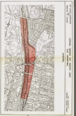
That report, released October 1964, would feature an upwards of 37 potential routes, with preliminary options almost entirely nowhere near the railroad, and with a 'recommended route' partially along the railroad but with serious route deviations in Brookland, D.C. (placing it further way from Catholic University) and especially in Takoma Park MD.  that latter route rather than displacing about 30 residences along the railroad would instead swing 1/3 of a mile further east on a longer route instead displacing some 471 houses in Takoma Park's oldest neighborhoods- understandably sparking massive protests.  At this time President Johnson would further stroke local resentment by stating his opposition to any freeway to the west of Rock Creek Park- despite the comparative impacts.

1964

Despite JFK''s vision for a low level freeway along the B&O railroad, officials in 1965 touted a quad decked elevated freeway above the railroad.

 1965

http://wwwtripwithinthebeltway.blogspot.com/2006/11/1965-elevated-multi-level.html

It was not until late 1966 that they finally released a study report roughly conforming to JFK;s 1962 planning.

1966

http://wwwtripwithinthebeltway.blogspot.com/2006/11/1966-north-central-freeway.html

Though conforming to public opinion, officials came under attack by the Committee of 100, which had supported JFK' B&O route North Central Freeway concept, turned 180 degrees.   Through the law firm of Covington & Burling a law suit alleging lack of proper approval was pursued- that the freeway lacked the approval of the necessary entities - the DC City Council and NCPC, when in fact such bodies then supported the B&O route freeway, before themselves withdrawing their support by late 1968.   Such a reversal of official support would come only AFTER the actions of other officials, namely within the created in 1967 US Federal Highway authority to come out in support of reverting to the infamous 1964 planning to save a few million dollar upon retaining walls.

Top officials of the Bureau have ordered a full review of the plans for the 3 ½ mile road … While it is good practice to disrupt as few people as possible in road building, is it worth the added cost of $22 million?

… Rejection by the Bureau would certainly fan the embers of one of the Washington area’s freeway controversies spearheaded by a group called the Save Takoma Park Committee. It rallied the residents of the middle income suburb composed largely of turn of the century homes on tree lined streets to strident opposition at hearings in Washington and Silver Spring on the original [1964] alignment.

A local citizen from Takoma Park, MD in 1967 would write in a letter to Spiro Agnew:

The re-studied proposal also tacitly admitted that the route first proposed was needlessly, even carelessly if not ruthlessly, destructive of our communities. The new version hugged both sides of the existing Baltimore and Ohio railway, thus avoiding a new swath of destruction to divide our communities and sharply reducing the number of homes to be taken.

The reduced, re-routed proposal was made public last year with endorsement of D.C. And Maryland highway authorities. The D.C. Portion was forced through the National Capital Planning Commission by votes of representatives of the D.C. Highway Department and of the U.S. Bureau of Public Roads. From this we concluded, reasonably enough, that the highway authorities of the two jurisdictions (Maryland and D.C.) had reached a firm understanding with the Bureau of Public Roads.

Many of us were therefore astonished and aroused to preparations for renewed protests when Washington newspapers recently reported that the Bureau has acted to open it all up again. We have not found the Bureau forthcoming with candid information, but the press articles intimate an intention to force Maryland to accept modifications of route or design ostensibly "cheaper."

The result is that the whole controversy, which had been somewhat quiescent, is beginning to agitate the communities again. I can assure you this is so, for although I recently resigned chairmanship of the Metropolitan Citizens Council for Rapid Transit and write this simply as an individual citizen who wishes your administration well, I do remain in close touch with neighborhood sentiment on transportation-related issues.

Official noise favoring the 1964 plan would continue into 1968 until both the D.C. City Council and U.S. National Capital Planning Commission (NCPC) formally reversed their support for any NCF Freeway, ignoring the distinctions between the 1964 and 1966 planning, along with its utility for providing what would have been Washington D.C.'s sole northern radial freeway.

 With respect to interstate traffic moving into the metropolitan area from the north on I-70S and I-95, vehicles with destinations beyond the District clearly should be diverted around the beltway. Interstate traffic with destinations within the District has options that are obviously as satisfactory as such traffic finds in any metropolitan system. The interstate system -- as a city to city system -- gives no assurance of freeway access to the heart of the central city. Both I-70S and I-95 traffic can move down the same arterial street network used by the commuters, and presumably a large part of this interstate traffic will be at non-peak hours.

I-95 traffic can be channeled over a short jog on the beltway to the Baltimore Washington Parkway for a penetration into the District over that route. Three options would be provided for this interstate traffic with downtown destinations -- via Kenilworth Freeway, via the proposed new Anacostia Parkway, and via New York Avenue (which is being improved as a major entrance into the Nation's capital from the east). Additional capacities to handle this I-95 traffic, of course, will of course be needed on the beltway and the Baltimore Washington Parkway. (An alternative would be a new highway in Maryland that would bring I-95 directly into the Baltimore-Washington Parkway at or near the Kenilworth interchange.)

The Commission believes that these facilities can adequately provide for interstate traffic from the north with central area destinations. The construction of a freeway to the north (in addition to the string of major surface streets) in order to accommodate interstate traffic would simply open up another arterial gateway for the suburban commuter. This the Commission rejects as both unnecessary and undesirable. (pp. 31-32)

Local impacts were given as the reason of this opposition which focused disproportionately along 69 residences between the east side of the freeway route and the west side of 10th street NE.  I say disproportionately, owing to the relative lack of attention to the some 600-1000 further south and west for the final connecting segment to the Center Leg - todays I-395 3rd street tunnel, let alone the lack of attention to the geometric reality that that latter segment's impact is reducible to a mere 33 or 34 if it were to run beneath the recreation field of Dunbar HS as a tunnel.   Such is a strange omission, given all of the hoopla over stopping 'white mans roads through black man home'.

In the meantime the Committee of 100 would promote an alternative plan- with far less local serviceability and greater environmental impact running along a far lengthier segment of the Northwest Branch.  Peter Craig of DC highway fighting fame since the late 1950s battle over the NW freeway went from proposed cut and cover tunnels with existing right of ways in 1962 to such more out of the way routes with far higher impacts.  This was done under what we could call a mockery of environmental justice.

1968 'Committee of 100' I-95 Proposal


1966 'lid' proposal for I-95 B&O North Central Freeway alongside Catholic University of America southwards from Taylor Street


1971 'lid' proposal for I-95 B&O North Central Freeway from just north of Michigan southward to Rhode Island Avenue- I am not aware of Catholic University of America ever objecting to the deletion of the 'lid' segment northward to Taylor Street alongside the main body of its campus

In the time since such theatrics, the freeways have remained unbuilt.  This includes an extension of the SE Freeway along the western shore of the Anacostia River that could be relatively easily built as a box tunnel freeway to better open up thatwaterfront to local use, while providing a valuable alternative route to the outdated existing Anacostia Freeway to the east- better facilitating that latter freeway's reconstruction in a below grade tunnel.

SE Freeway Extension - East Leg of the Inner Loop Late 1960s

In the meantime, a madness has engulfed local planning with ill-advised real estate development to constrict the North Central-North East route.  This includes a hideously placed, yet approved by U.S. NCPC PERJURY residential development project ‘The Hampshires’ by Comstock on a key property needed to connect the B&O and the New Hampshire-PEPCO inside the Beltway I-95 route- an infinitely superior and more environmentally friendly alternative to the long planned Northwest Branch route.


All of this ill development betrays the public interest and places a disproportionate amount of the traffic burden upon less affluent areas.

Monday, April 09, 2012

Continually Ignoring Un-Built D.C. I-95 - 3

Nice of the Washington Times to run an editorial titled "Freeways are the solution to congestion" without mentioning any of the still un-built freeways within the Beltway, particularly in Washington, D.C., though dissing the concept of tolling which would make such new freeways more fund-able


http://www.washingtontimes.com/news/2010/apr/09/freeways-are-the-solution-to-congestion/

As is the case in major metropolitan areas throughout the country, congestion plagues Northern Virginia. The constant traffic snarls impede business, pollute the environment and generally make living in the region an unpleasant experience.

This doesn’t mean - as the Fairfax County Chamber of Commerce suggests - that toll roads are in any way a solution to the problem. To the contrary, a toll road’s financial survival depends upon perpetual congestion in the road network as a whole.

The explanation is straightforward. Given alternative routes without traffic, no rational consumer would fork over his hard-earned cash to take a tolled highway. Purportedly “innovative” public-private partnerships ensure that this situation never exists by securing non-compete contract clauses that either directly prevent or indirectly discourage improvements to nearby free roads. Happy commuters are not paying customers.

Take the Capital Beltway high-occupancy toll (HOT) lane deal between the Virginia Department of Transportation (VDOT) and the tolling firm Transurban. Under section 9.02 of the contract, improvements made to the Beltway’s general-purpose lanes without Transurban’s permission trigger “compensation events.” This scheme forces Virginia taxpayers to pay ransom to the Australian firm before the free lanes can be widened within the next 80 years. The payment would be based on an estimate of the financial loss to the tolled lane from improvements to the free lanes.

This is the equivalent of Ford customers being forced to make payments to Toyota if improvements to the American product attracted customers away from the Japanese marque. Nobody would consider such an arrangement to be in any way free-market. Nor is market competition involved when a private foreign corporation profits on the backs of taxpayers after taking federal and state grants, loans and guarantees subsidizing 82 percent of the project’s total cost.

That sum, including tolls paid over the lifetime of the scheme, amounts to billions more than it would have cost the public to construct the same lanes as part of a traditional freeway. The construction of additional free-lane capacity is the only permanent solution to gridlock.

Local bureaucrats steadfastly have opposed adding new capacity. Instead, officials kowtow to special interests infatuated with the concept of spending other people’s money - in this case through motorist user fees. No better example of this can be found than the $5.3 billion that drivers will pay to subsidize the Dulles Metrorail extension, not counting the billions more in cost overruns, financing charges and operational subsidies over the project’s lifetime.

Fortunately, Northern Virginians can look forward to a small bit of relief on Interstate 66 inside the Beltway. This summer, VDOT will begin a modest project expanding the overloaded highway’s capacity, starting with the stretch between Fairfax Drive and Sycamore Street. Commuters should thank Rep. Frank R. Wolf, Virginia Republican, for his persistence in driving this project over the objections of the not-in-my-backyard crowd.

This road carries 110,000 vehicles to and from work every day, and the first phase of Mr. Wolf’s project will cost just $19 million. By comparison, the Federal Transit Administration estimates that the Dulles rail project will benefit about 35,000 persons on weekdays - meaning the cost for each regular user will be $150,000.

Unless this region puts a stop to these wasteful transit boondoggles and tolling schemes, the congestion will only get worse.


---

OK then- how about the Washington Times calling for constructing the I-270E/I-95 Grand Arc Mall Tunnel, under-grounding the B&O Metropolitan Branch RR, I-95 PEPCO connector, crosstown I-66 K Street New York Avenue Tunnels, and augmented Center Leg/under-grounded SW-SE Freeway?

How about protecting the Center Leg (3rd Street Tunnel) from ill advised details that would squander its design capacity, of otherwise sensible real estate development projects.

How about ensuring that SW re-development preserves the space for USNCPC's excellent Washington Channel Tunnel concept?

Saturday, December 17, 2011

Within The Beltway


See the botching of the planning of I-95 through Washington, D.C. starting in 1963 months after the U.S. President issued a report for I-95 to run near Catholic University of America:
http://wwwtripwithinthebeltway.blogspot.com/2010/05/1960s-washington-dc-freeway-planning.html

Late 1963-1964 study DISREGARDS JFK's prescription for freeway to hug RR
http://wwwtripwithinthebeltway.blogspot.com/2007/05/1964-north-central-freeway-routing_08.html

Federal City Council subverts support for DC I-95 (mere weeks before 'supplementary' report faithful to JFK 1962 B&O Route) by calling for the disastrous 1964 route as "cheaper" (though a longer route taking 471 houses rather then some 30)
http://wwwtripwithinthebeltway.blogspot.com/2010/05/fallacy-of-federal-city-councils.html

Officials fail to commit to JFK B&O railroad route, waffling towards disastrous 1964 plan, as late as 1968 (the year that USNCPC reversed itself and went against freeway)
http://wwwtripwithinthebeltway.blogspot.com/2010/05/significence-of-waffling-on-b-north.html

Letter to Maryland Governor Agnew, 1967 on how waffling on North Central Freeway planning was inciting opposition.
Citizens of Takoma Park and Silver Spring had reason for their demonstrations of bitter dissatisfaction with the highway authorities of your predecessor's administration. After we had been given reason to believe that the causes of our protests had been in at least some part overcome, the matter now threatens to break into renewed bitterness. I am sure you will wish to avoid this as much as many of us.

We showed that the methods of traffic projections which were claimed to justify the North Central were fallacious, the results in error by as much as 400 percent. Our contention was tacitly admitted in "re-studied" versions of the proposal made public last year, sharply reducing the original plan of 5 lanes each way.

The re-studied proposal also tacitly admitted that the route first proposed was needlessly, even carelessly if not ruthlessly, destructive of our communities. The new version hugged both sides of the existing Baltimore and Ohio railway, thus avoiding a new swath of destruction to divide our communities and sharply reducing the number of homes to be taken.

The reduced, re-routed proposal was made public last year with endorsement of D.C. And Maryland highway authorities. The D.C. Portion was forced through the National Capital Planning Commission by votes of representatives of the D.C. Highway Department and of the U.S. Bureau of Public Roads. From this we concluded, reasonably enough, that the highway authorities of the two jurisdictions (Maryland and D.C.) had reached a firm understanding with the Bureau of Public Roads.

Many of us were therefore astonished and aroused to preparations for renewed protests when Washington newspapers recently reported that the Bureau has acted to open it all up again. We have not found the Bureau forthcoming with candid information, but the press articles intimate an intention to force Maryland to accept modifications of route or design ostensibly "cheaper."

The result is that the whole controversy, which had been somewhat quiescent, is beginning to agitate the communities again. I can assure you this is so, for although I recently resigned chairmanship of the Metropolitan Citizens Council for Rapid Transit and write this simply as an individual citizen who wishes your administration well, I do remain in close touch with neighborhood sentiment on transportation-related issues.
And afterwards that Washington, D.C. powerhouse law firm Covington & Burling PAYS for anti-freeway riots in the DC City Council
http://wwwtripwithinthebeltway.blogspot.com/2009/10/ectc-paid-to-riot-via-covington-burling.html

Who Really Stopped Washington, D.C.'s Freeways
http://wwwtripwithinthebeltway.blogspot.com/2008/12/who-really-stopped-washington-dcs.html

Political Mass Within The Beltway
http://wwwtripwithinthebeltway.blogspot.com/2010/09/washington-dcs-supreme-bridge-builder.html

A Sampling of Attitudes Towards D.C. I-95
http://wwwtripwithinthebeltway.blogspot.com/2007/02/sampling-of-attitudes-towards-dc-i-95.html
These were a group of black-clothed priests that attended my June 5, 2005 presentation near Catholic University of America, at the Archbishop Carroll High School through the D.C. NE Historical Society. My presentation was "The Never-Built Freeways of Northeast D.C.: The Plans and the Controversy, Part I" by Douglas A. Willinger of the Takoma Park Highway Design Studio. IIRC, these men were identified to me as Jesuits: members of the Jesuit Order, established by Ignatius Loyola in 1543 to counter the Protestant Reformation, via strategizing to further and expand the power of the Vatican/Roman Catholic Church....

I remember two of these men in particular, one white haired elderly, described to me as liking to jump on the bandwagon rather then think for himself, and a young, dark haired, reddish complexion one – too young to have been more then a child when D.C. I-95 was canceled in 1968-1973 – who appeared to me to be of mixed Irish and German ancestry. It was he who expressed the astonishment that they were actually going to run I-95 through Washington, D.C., as if that was somehow unfathomable. He did not appear too pleased to hear me discuss its feasibility, even as I acknowledged the shortcomings of the earlier designs (and that I felt it was right to stop those earlier specific plans, such as the 1964 plan’s demolition of Brooks Mansion).

Figuring that these men had an interest in what they would likely call “social justice” matters, I ended my laptop projection presentation with my own example of activism: the South Capitol Street/ Frederick Douglass Mall, and its desecration by the atrociously placed Nationals Ball Park Stadium, with the visual image of the stamp-pair that I had created with Ian Goddard in early 2005. I looked forward to an interesting discussion.


http://wwwsouthcapitolstreet.blogspot.com/2007/12/south-capitol-street-frederick-douglass.html

http://wwwsouthcapitolstreet.blogspot.com/2006/07/physical-reality-only-structure-along_22.html

Instead there was only a cold silence.

Such so far reflects the general attitude of the authorities towards any urban freeways.
JFK Gave Us the "Y" Route I-70S-I-95 B&O RR Route D.C. North Central Freeway
http://wwwtripwithinthebeltway.blogspot.com/2010/05/jfk-administration-gave-us-b-north.html

Recommendations for Transportation in the National Capital Region: A Report to the President for transmittal to Congress by the National Capital Transportation Agency November 1, 1962

At page 44:
Significance of Using B&O Route. Use of the Baltimore & Ohio Railroad corridor to bring Routes 70-S and 95 into the city is the key to meeting the need for additional highway capacity in northern Washington, Montgomery County and northwestern Prince Georges Counties and at the same time avoiding the substantial relocation of persons, loss of taxable property and disruption of neighborhoods that would result from construction of the Northeast, North Central and Northwest Freeway proposed in the 1959 plan. Further savings are realized by placing the rapid transit line to Silver Spring and Queen’s Chapel in the same railroad corridor.
And, at pages 25-26:
Three Sisters Bridge In the 1959 plan, Three Sisters Island Bridge was part of an intermediate loop (located between the Capital Beltway and the proposed inner loop) that virtually circled the city. The Agency's studies show no need for the portion of the intermediate loop between the Potomac River and the Soldiers Home area. Standing alone, the only purpose of Three Sisters would to bring trucks and additional auto traffic from Fairfax and Arlington Counties into downtown. For that purpose the bridge is not required.

As of 1957, there were a total of 22 bridge lanes across the Potomac River. Projects now under construction, or recently completed, will nearly double the number of such lanes ... [while] The Agency proposes two rail rapid transit lines to Virginia, one of which would serve the Three Sisters Bridge corridor. Rapid transit service would not have been provided in this corridor under the 1959 plan. With such service available, in 1980 a total of over 30,000 people - many of whom would otherwise be using their autos - would use public transportation from Virginia into the District in the morning peak hour, enough to fill 12 bridge lanes ... The result, as the following table shows, is that under the plan recommended by the Agency, central area bridge capacity will be adequate for the needs of motorists in 1980 without Three Sisters Bridge.
Yet a June 1, 1963 letter enumerates the cross town I-66 North Leg and Three Sisters Bridge as the most controversial segments require further study
“…I noted that certain portions of the highway network within the District of Columbia required further study. The guidelines which I believe should be followed in this re-examination are as follows:

The re-examination should focus upon the sections of the highway plans which have from the beginning been the most uncertain and the most controversial- the North Leg of the Inner Loop and the Three Sisters Bridge, both of which involve the manner in which necessarily involve a re-study of those additional portions of the plan which are directly affected by the conclusions reached in the re-examination…”
Since his November 1962 report had rejected the Three Sisters Bridge, his June 1963 letter calling for that bridge's 're-examination' meant that it might be needed, hence having JFK place freeways alongside Catholic University of America and Georgetown University.

Cancelled D.C. I-95 next to Catholic University of America

The canceled I-266 Three Sisters Bridge- pointing at Georgetown University

If only JFK had not been assassinated, he would have asked why J.E. Greiner dissed his prescription for the freeway to hug the railroad centrally located between the Potomac River and the eastern portion of the I-495 Capital Beltway, hence resulting in the freeways' political demonification. JFK specified the B&O Route, as "the key", to bringing I-70S and I-95 into Washington, D.C. "avoiding the substantial relocation of persons, loss of taxable property and disruption of neighborhoods that would result from construction of the Northeast, North Central and Northwest Freeway proposed in the 1959 plan"; yet the 1964 Greiner 'North Central Freeway' report excluded it, instead offering an upwards of 37 routes each with a far far higher amount of local impacts, akin to that in the 1959 planning. And it offers up a recommended route partially along the railroad but with serious deviations upon longer routes in Takoma Park Maryland and to a lesser degree in Brookland, D.C., creating mass opposition.

Apparently, none of the media outlets asked why the 1963-64 North Central Freeway engineering study report, released in October 1964, so deviated from JFK's proposal. In researching the history of Washington, D.C.'s un-built freeways I have yet to see this question about the Greiner report's betrayal of the JFK freeway plan addressed.