With the VATICAN being the Entity Behind the Assassination of JFK to thwart D.C. I-95?
"And so, my fellow Americans: ask not what your country can do for you - ask what you can do for your country" - JFK inaugural speech with message applicable to situation of lack of northern radial freeways in Washington, D.C.
Assassination of 11-22-63 to Thwart I-95 Through Washington, D.C. alongside the proposed motorway's most logical route:
centrally located northern radial railroad-industrial corridor - immediately
alongside Catholic University of America
A
basic logic scenario- something that JFK adopted about a year before
11-22-63: marked by being politically botched deliberately, being something that JFK played a more active interest than say his predecessor Dwight Eisenhower. See the 1963 and 1965 Boston Inner Belt study reports
which shows various partially open tunnel box for the Fenway segment- that would be logically needed as the buildings facing the Fen as those of Catholic University of America
Perhaps JFK likely that he noticed that great view southbound from the CUA
side of the RR- and therefor ran afoul of that political entity all too self entitled to get its way no-matter what, clearly something with too much political power that subverts major planning.
1963 Boston Inner Loop Study Report
Did JFK dare suggest a tunnel box variant for the southbound I-95 carriageway along the Washington, D.C.B&O Route I-95?
Washington, D.C. freeway planning back-drop:
1955 - Inner Loop Study Report for the downtown 'hub' for connecting the various radial routes
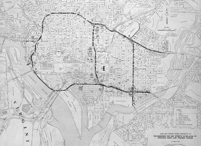
also see 1956 NW Freeway Study Report
1959 - Mass Transportation study.

1959 plan with 3 northern radial freeways (also open to trucks)
left to right
I-70S NW Freeway, North Central Freeway, I-95 NE Freeway
1959 - NW Freeway incorporated work from 1956 study report indicating that the Wisconsin Avenue NW corridor route would displace 74 dwellings from the MD-DC line to Tenley Circle.

1959 I-70S NW Freeway with cut and cover tunnel segments beneath Tenley Circle,
and the segment crossing beneath Connecticut Avenue,
plus a drilled tunnel segment in the vicinity of Sidwell Friends School
Included a Glover Archibold Parkway (excluding trucks)

1959 I-70S NW Freeway 'Cross Park Freeway'
extension to interchange with I-66
as planned 1955+ as an open trench between T and U Streets
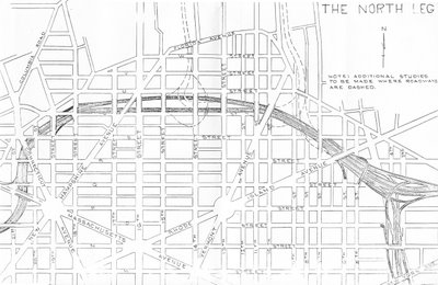
I-66 North Leg as planned 1955+
1960 - the U.S. Congress adopted its first formal application of this break from equal protection via that year's National Transportation Act's moratorium against any development of any new freeways west of Rock Creek Parkway. Never-mind the disproportionate deference already evident with $$$ rather than number of victims, aka to just which side of Rock Creek Park?
A mere 74 dwellings displaced for the segment from the MD-DC line at Friendship Heights to the area just south of Tenley Circle, plus ZERO for the western portion of the 'Cross Town Freeway', but perhaps 1,000 to the east through the Mt. Pleasant area to the planned interchange at 14th and U Streets with the I-66 North Leg as planned 1955+.
Yet it was the political opposition with the least asked for local sacrifice - to Rock Creek Park's west that got it stopped rather than the east- despite the offering of tunneled segments for the former but not the latter.
1960 also
brought the initial engineering report on the I-95 Northeast Freeway, with a number of alternative routes and a recommended route taking some 1,095.
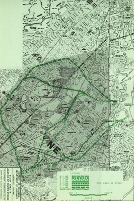
1960 B&O Route [more or less] D.C. I-95 -
Catholic University of America/Brookland area
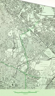
1960 D.C. I-95 NE Freeway with connections to the Inner Loop
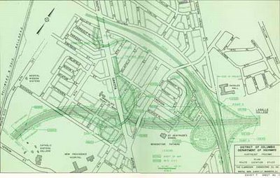
Note the 1960 D.C. I-95 NE Freeway connection to the DC-MD line:
'Catholic Sisters Route'
By 1962 this portion of the D.C. I-95 route -- 'Catholic Sisters' -- was changed to the nearby 'Fort Drive Route' owing to the open opposition of the Roman Catholic Church, over lands that it would later sell off for more dwellings.
Between 1960 and 1962 with the moratorium on the nonetheless logical far NW Freeway, aka one along the Wisconsin Avenue corridor, a consensus developed that the solution was a double consolidation, of I-70S thus with North Central Freeway, itself ABANDONING the concept of a major freeway along the Georgia Avenue corridor, replaced along the historically established B&O Metropolitan Branch Railroad built a century previously, and intercepting I-95 from MD via the 'Fort Drive' route- south-ward of this I-70S-B&O/I-95 confluence known as the I-95 B&O North Central Freeway.
 By late 1962 this consensus led to the B&O Route's adaptation by the White House, as the left and center portion of a "Y"- hence an I-70S designation north of the confluence with I-95. This basic route was a key point of the White House report dated November 1, 1962 "Recommendations for TRANSPORTATION in the NATIONAL CAPITAL REGION Finance and Organization A Report to the President for transmittal to Congress by the NATIONAL CAPITAL TRANSPORTATION AGENCY", see
 page 44:
Significance of Using B&O Route. Use of the Baltimore & Ohio
Railroad corridor to bring Routes 70-S and 95 into the city is the key
to meeting the need for additional highway capacity in northern
Washington, Montgomery County and northwestern Prince Georges Counties
and at the same time avoiding the substantial relocation of persons,
loss of taxable property and disruption of neighborhoods that would
result from construction of the Northeast, North Central and Northwest
Freeway proposed in the 1959 plan. Further savings are realized by
placing the rapid transit line to Silver Spring and Queen’s Chapel in
the same railroad corridor.
1962 White House Report B&O+Fort Drive Route D.C. NE I-95
In addition, the 1962 White House report offered a series of secondary depressed 'express streets' - think of the two North Capitol Street underpasses where it crosses Rhode Island and New York Avenues, such as that seen in a 1962 Study Report about such an 'express street' for S Street NW as a substitute for the I-66 North Leg. Also, regarding that somewhat more controversial idea of a Bridge at 3 Sisters, the 1962 report rejected: quote of the 1962 report on 3 Sisters Bridge at pages 25-26:
Three Sisters Bridge
In the 1959 plan, Three Sisters Island Bridge was part of an
intermediate loop (located between the Capital Beltway and the proposed
inner loop) that virtually circled the city. The Agency's studies show
no need for the portion of the intermediate loop between the Potomac
River and the Soldiers Home area. Standing alone, the only purpose of
Three Sisters would to bring trucks and additional auto traffic from
Fairfax and Arlington Counties into downtown. For that purpose the
bridge is not required.
As of 1957, there were a total of 22
bridge lanes across the Potomac River. Projects now under construction,
or recently completed, will nearly double the number of such lanes ...
[while] The Agency proposes two rail rapid transit lines to Virginia,
one of which would serve the Three Sisters Bridge corridor. Rapid
transit service would not have been provided in this corridor under the
1959 plan. With such service available, in 1980 a total of over 30,000
people - many of whom would otherwise be using their autos - would use
public transportation from Virginia into the District in the morning
peak hour, enough to fill 12 bridge lanes ... The result, as the
following table shows, is that under the plan recommended by the Agency,
central area bridge capacity will be adequate for the needs of
motorists in 1980 without Three Sisters Bridge.
Owing to concerns that the proposed 2x2 'express street would be inadequate, along with abandoning the Crossing at 3 Sisters, a follow-up letter dated June 1, 1963 letter enumerates the cross town I-66 North Leg
and Three Sisters Bridge as the most controversial segments require
further study
“…I noted that certain portions of the highway network within the
District of Columbia required further study. The guidelines which I
believe should be followed in this re-examination are as follows:
The re-examination should focus upon the sections of the highway
plans which have from the beginning been the most uncertain and the most
controversial- the North Leg of the Inner Loop and the Three Sisters
Bridge, both of which involve the manner in which necessarily involve a
re-study of those additional portions of the plan which are directly
affected by the conclusions reached in the re-examination…”
With his November 1962 report having rejected the Three Sisters Bridge,
his June 1963 letter calling for that bridge’s ‘re-examination’ meant
that it might be needed, hence having JFK place freeways alongside
Catholic University of America
and Georgetown University.
Canceled B&O D.C. I-95 next to Catholic University of America
The canceled I-266 Three Sisters Bridge- pointing at Georgetown University
That report dated November 1, 1962 was supposed to be followed in about 6 months, yet is delayed to near a full year AFTER his controversial assassination on November 22, 1963, in late 1964.
1964 Initial Engineering Study Report - North Central Freeway
 OVERVIEW
http://wwwtripwithinthebeltway.blogspot.com/2006/11/1963-64-north-central-freeway-study.html
OVERVIEW
http://wwwtripwithinthebeltway.blogspot.com/2006/11/1963-64-north-central-freeway-study.html
REPORT - PLATES
http://wwwtripwithinthebeltway.blogspot.com/2008/05/1964-north-central-freeway-report-je.html
REPORT - FULL TEXT & CHARTS (Complete)
http://wwwtripwithinthebeltway.blogspot.com/2012/02/october-1964-north-central-freeway.html
REPORT - ON THE B&O ROUTE
'PIN POINT THE B&O CORRIDOR ONLY AFTERWARDS'
http://wwwtripwithinthebeltway.blogspot.com/2012/01/pin-point-b-rr-in-dc-only-after-more.html

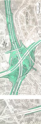
Interchange with the I-495 Capital Beltway
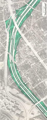
Along 16th Street to the east side of the B&O Railroad
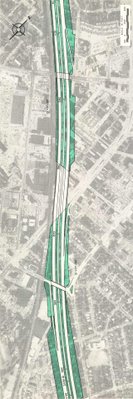
Along the B&O railroad in downtown Silver Spring, Maryland, swinging away from the RR to the south to go upon a longer route than the RR through Takoma Park.
Veers about 1/2 mile away from the B&O railroad on new swath through old neighborhoods in Takoma Park, Maryland, taking 471 houses for the 1.1 mile segment, before rejoining the railroad immediately north of New Hampshire Avenue
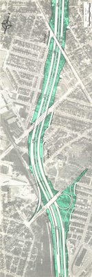
re-joining the RR by New Hampshire Avenue
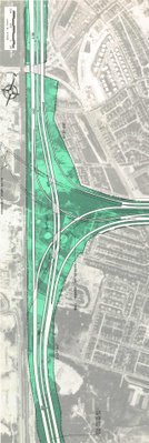
Interchange with I-95 Northeast Freeway via the Fort Drive route;
from this point south, the North Central Freeway carried the I-95 designation
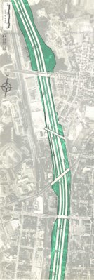
I-95 North Central Freeway at western Brookland by Catholic University of America
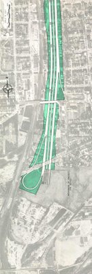
North Central Freeway at Rhode Island Avenue

The engineering study for the North Central- Northeastern "Y" Route
I-95/70S Freeway ordered in 1962 or early 1963 and its report supposed
to take about 6 months, yet delayed until October 1964 stated:
During the preliminary line studies it became evident that the pin pointing the general corridor of the Baltimore and Ohio Railroad in the District of Columbia should only be accomplished only after more detailed investigation of a band of alignments in that area
Why?-
considering that the idea of highway routes in such bands as the
Georgia Avenue corridor were debated cir 1960-62, and abandoned in favor
of the JFK administration's B&O 'Y' Route?!
If only JFK had not been assassinated, he would have asked why J.E.
Greiner dissed his prescription for the freeway to hug the railroad
centrally located between the Potomac River and the eastern portion of
the I-495 Capital Beltway, hence resulting in the freeways’ political
demonification.
JFK specified the B&O Route, as “the key”, to
bringing I-70S and I-95 into Washington, D.C. “avoiding the substantial
relocation of persons, loss of taxable property and disruption of
neighborhoods that would result from construction of the Northeast,
North Central and Northwest Freeway proposed in the 1959 plan”; yet the
1964 Greiner ‘North Central Freeway’ report excluded it, instead
offering an upwards of 37 routes each with a far far higher amount of
local impacts, akin to that in the 1959 planning. And it offers up a
recommended route partially along the railroad but with serious
deviations upon longer routes in Takoma Park Maryland and to a lesser
degree in Brookland, D.C., creating mass opposition.
1966
Federal City Council subverts support for D.C. I-95 (mere weeks before ‘supplementary’ report faithful to JFK 1962 B&O Route) by calling for the disastrous 1964 route as “cheaper” (though a longer route taking
471 houses rather then some 30)
The
'Supplementary' North Central Freeway Study Report that essentially followed the assassinated President's adopted concept from 1962.
http://wwwtripwithinthebeltway.blogspot.com/2010/05/fallacy-of-federal-city-councils.html

1966 Supplementary North entral freeway Study Report
note the I-66 North Leg as a straight tunnel beneath K Street
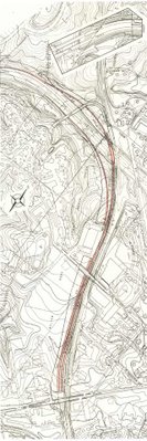
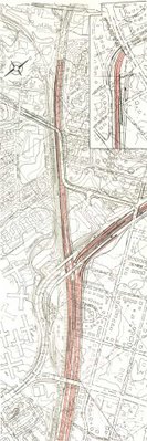
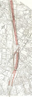
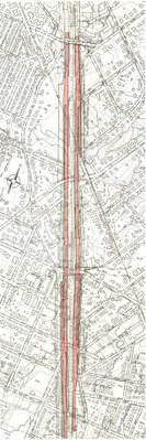
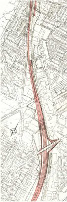
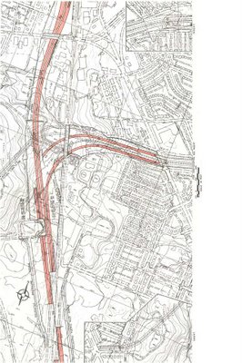
Retains the Fort Drive alignment for the I-95 Northeast Freeway from Maryland via Northwest Branch Park; but it realigns the North Central Freeway to the west, increasing its impacts on Fort Totten Park- hence creating a new objection.
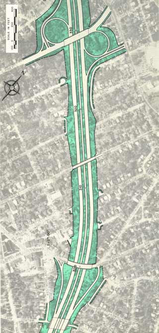
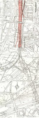
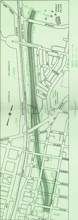
1964 North Central Freeway at Brookland-Catholic University of America, with area of proposed 'lid' to cover the freeway and even the RR in the area alongside the main campus of CUA. I have seen nothing indicating any objections from CUA regarding this area of 'lid' being deleted.
Entirely to the east of the railroad further south in Brookland, it avoided Turkey Thicket and Brooks Mansion, reducing the number of dwellings for the I-95 portion of the North Central Freeway to 69 houses (1910-20s vintage).
This 1966 North Central - Northeast Freeway B&O Low level option proved too uncontroversial for the newly formed Federal Highway Authority to restraining itself from a further botching of the planning, by failing to commit to JFK B&O railroad route, waffling
towards disastrous 1964 plan, as late
as 1968 (the year that U.S. National Capital Planning Committee reversed itself and went against freeway).
http://wwwtripwithinthebeltway.blogspot.com/2010/05/significence-of-waffling-on-b-north.html
Letter to Maryland Governor Agnew, 1967 on how waffling on North Central Freeway planning was inciting opposition.
Citizens of Takoma Park and Silver Spring had reason for their
demonstrations of bitter dissatisfaction with the highway authorities of
your predecessor’s administration. After we had been given reason to
believe that the causes of our protests had been in at least some part
overcome, the matter now threatens to break into renewed bitterness. I
am sure you will wish to avoid this as much as many of us.
We showed that the methods of traffic projections which were claimed
to justify the North Central were fallacious, the results in error by as
much as 400 percent. Our contention was tacitly admitted in
“re-studied” versions of the proposal made public last year, sharply
reducing the original plan of 5 lanes each way.
The re-studied proposal also tacitly admitted that the route first
proposed was needlessly, even carelessly if not ruthlessly, destructive
of our communities. The new version hugged both sides of the existing
Baltimore and Ohio railway, thus avoiding a new swath of destruction to
divide our communities and sharply reducing the number of homes to be
taken.
The reduced, re-routed proposal was made public last year with
endorsement of D.C. And Maryland highway authorities. The D.C. Portion
was forced through the National Capital Planning Commission by votes of
representatives of the D.C. Highway Department and of the U.S. Bureau of
Public Roads. From this we concluded, reasonably enough, that the
highway authorities of the two jurisdictions (Maryland and D.C.) had
reached a firm understanding with the Bureau of Public Roads.
Many of us were therefore astonished and aroused to preparations for
renewed protests when Washington newspapers recently reported that the
Bureau has acted to open it all up again. We have not found the Bureau
forthcoming with candid information, but the press articles intimate an
intention to force Maryland to accept modifications of route or design
ostensibly “cheaper.”
The result is that the whole controversy, which had been somewhat
quiescent, is beginning to agitate the communities again. I can assure
you this is so, for although I recently resigned chairmanship of the
Metropolitan Citizens Council for Rapid Transit and write this simply as
an individual citizen who wishes your administration well, I do remain
in close touch with neighborhood sentiment on transportation-related
issues.
From the Washington Post report, May 8, 1967:
Top
officials of the Bureau have ordered a full review of the plans for the
3 ½ mile road … While it is good practice to disrupt as few people as
possible in road building, is it worth the added cost of $22 million?
…
Rejection by the Bureau would certainly fan the embers of one of the
Washington area’s freeway controversies spearheaded by a group called
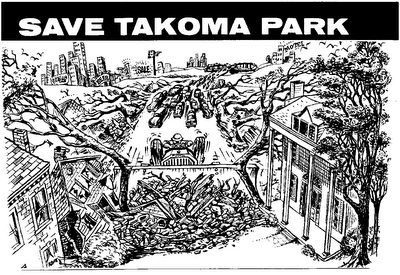
the Save Takoma Park Committee. It rallied the residents of the middle
income suburb composed largely of turn of the century homes on tree
lined streets to strident opposition at hearings in Washington and
Silver Spring on the original [1964] alignment.
This cheap skate attitude surely served the purpose of poisoning popular sentiment against the B&O North Central Freeway.
Notably latter 1966- early 1967 was a time of transition and
bureaucratic reorganization, with the U.S. Bureau of Roads being
replaced by the then brand new U.S. Federal Highway Authority, with the
outgoing administrator
Rex Marion Whitton, who served from 1961 to 1966,
quoted by the Kansas Evening Star about his retirement that at [the age of] 68
"I want to get out while I am still winning or at least that I am still winning"
as if on que of an impending planned scuttling.
Rex Marion Whitton

Lowell K. Bridwell
His successor,
Lowell K Bridwell
(1967-69) was later the FHWA director overseeing New York City’s to be
scuttled Westway Project, which would have replaced Manhattan's elevated
West Side Highway with a modern interstate highway, the southern part
via a tunnel in new land fill within the pier area, beneath a new
waterfront promenade, parkland and new development. That would provide the
perpetual benefit of property tax revenue, thereby creating an new
source of perpetual property tax revenues; the Westway Project would
have no expense to the City of New York , yet was unfairly maligned as a
waste of money, as a reflection of the generalized post 1961 idea that
the U.S. was too poor to afford highway and transit. Notably Bridwell
died in 1986 at the age of 62 a mere year after Westway’s September 1985
cancellation.
The dynamics of a high level decision to scuttle
the assassinated President's B&O Route North Central Freeway were
further displayed by the words and actions of again subverting the
B&O NCF by new US Department of Transportation Administrator Alan
Boyd, starting with the adaptation of the historical revisionism that
“forgets” to mention the route’s development 1961-1962, and its
subsequent botching. As the Washington Post reported, January 15, 1968
Transportation Secretary Alan S. Boyd, who has refused to approve plans
for the North Central Freeway, said yesterday the path of the road
through Northeast Washington was determined
not by “where the traffic wants to go,” but by where “political opposition was insufficient to stop it.”
“All
the traffic surveys say it should be built along the Wisconsin Avenue
corridor,” Boyd explained in an interview on WTOP television’s Capital
Conversation.
“But the
people who live along Wisconsin Avenue or have business there have much
more political clout than the people on the other side of town.”
Ten years ago the freeway was planned to run along the District shore of the Potomac River, Body said.
But it was pushed eastward,” he said, “until political opposition was insufficient to stop it.”
The
outer approved by the National Capital Planning Commission in 1966
would run from the Capital Beltway through Silver Spring Takoma Park,
and Northeast to a major interchange near Union Station. It would
provide high speed access to downtown Washington from eastern Montgomery
County.
“We’re going to
have to find a better way to do it than to say we’re going to take the
property of poor people and leave everyone else alone.” Body said.
“That’s not the way the way the traffic moves.”
Boyd
argued that highways could be built “to compact themselves reasonably
well” in any neighborhood if stores and homes were built in the air
space over the roads.
“We
should not just tear up the homes of poor people and Negroes,” Boyd
declared. “We ought t make a determined effort to put freeways where
traffic wants to go.
Boyd,
who said in November he would not approve another highway project, the
Three Sisters Bridge, as presently planned, said he would continue his
opposition until he knows “what’s going to happen to the traffic” that
would use it. Under present plans, he said, “there’s no provision for a
distribution system” to take heavy traffic from the bridge into the
Northwest section of Washington
And, as reported in
the Drew Pearson The Washington Merry Go Round column D.C. Mayor on Spot
in Freeway Fight (yes the Drew Pearson who maligned the Tucker Motor
Car), on February 21, 1968:
Secretary
Boyd also argues that Negro communities are not the only ones to be
relocated to make room for suburban freeways. Wealthier communities
should move too. Specifically he has held up the North Central Freeway
in Washington because it was shifted over from a high bracket
residential community to a low bracket , because the white residents
pack more political punch than Negroes do. “We should not just tear up
the homes of poor people and Negroes,” says Boyd. “We ought to make a
determined effort to put freeways where the traffic wants to go. We’re
going to have to find a better way to do it than say we’re going to take
the property of poor people and let everyone else alone.”
Boyd
conceivably had the option of promoting reviving the Northwest Freeway-
consider how that freeway could have fit within the re-development
footprint in downtown Bethesda- Boyd had practicalities that he could
have advanced: one could have pointed out that much of downtown Bethesda
was to be demolished and replaced owing to the inevitable transit
induced densification, and thereby promoted that segment as a cut and
cover tunnel beneath new buildings there as well as in Friendship
Heights; further south, where the grade must further descend owing to
the NW Washington D.C. topographically, one could promote a revision of
the southern portion via a deep drilled tunnel straight from the Tenley
Circle area to the existing end of I-66, roughly twice the length of the
1960 I-95 Northeast Freeway study option with 4 x 2 tunnels 4,000 feet
in length would have made a powerful backup to his statements concerning
social equality.

1965 local proposal for reviving a downtown Bethesda I-70S freeway
ignored by the Feds despite its clear and vital need!
Rather, he conformed with the dynamics
suggested by the outgoing U.S. Bureau of Roads chief's comments about
getting out "while it still appeared that we were winning." Indeed, he
not only repeats the established media "spin" concerning I-70S (that
'forgets' the 1961-62 history leading to the JFK Administration's
November 1, 1962, along with the route botching of the long delayed
initial engineering report), thereby sustaining a resentment against he
wealthier NW, he extends it to not only oppose I-70S along the railroad
through Silver Spring and the Takoma Park area, but also to I-95 through
the western edge of the Washington, D.C. neighborhood of Brookland,
displacing 69 WW1 era townhouses (with a 1970 revision reducing that to
34), just across the railroad from Catholic University of America.
Indeed this geographical class angle would be useful, given that B&O
and the Northeastern I-95 would have displaced but a fraction of that
for the I-70S segment, due to the later construction of brick houses
along the railroad's western side Blair Avenue, along with the
Montgomery Gardens apartment complex
constructed at about this very same time, near Blair Park.
The reaction of
"white mans roads through black mans homes"
had been the response to the botched planning unveiled in 1964, with
its review of a broad array of route options of the type of freeway
planning of the 1959 Mass Transportation Plan rejected by the planning
discussions that had lead to the adaptation of the I-70S / I-95 B&O
North Central Freeway in 1962 by the Committee of 100 on the Federal
City and the Kennedy Administration. Hence it was a betrayal of the
participants who accepted this eastward shift as the means of routing
I-70S with the least displacement (and as the most logical-cost
effective means employing the existing areas of the rail-yards for
routing traffic from I-70S and I-95 into and through the Inner Loop:
certainly a deep drilled I-70S tunnel from Tenley Circle to I-66 would
work,
especially with an under Potomac Tunnel to Virginia Route 27 and
or 110, but would not handle I-95 traffic, whereas the B&O concept
handles I-70S and I-95 traffic).
The 'social justice' idea
conveyed with this freeway planning politicization can be seen as a
history extending back a century earlier when the B&O Metropolitan
Branch was routed where it was in NE with that corridor significantly
industrialized, while the comparable stream valley in NW,
Archibald-Glover Park, remained more or less in its natural state.
Boyd
(like any other such FHWA figure) has the option of promoting a further
design evolution of the I-70S/ I-95 B&O North Central. One with
greater capacity, given his testimony before the House subcommittee on
roads -- reported by a December 6, 1967 Washington Post article "3 Major
Road Projects Are Unwise" -- against the North Central Freeway "as it
is now designed" describing it as "a tremendously expensive and
inadequate artery."
He could have promoted a re-design without
the neck-down and within a right of way avoiding the historic Brooks
mansion to the east, and the line of Catholic University of America
buildings to the west with the freeway entirely under-grounded
southwards of Taylor Street.
The extra capacity would come via an added cut
and cover tunnel carriageway along the railroad's
west side directly
beneath
John McCormack Drive- named for the 1961-1971 Speaker of the
U.S. House of Representatives.
Hence it would accommodate the traffic while
maintaining and even enhancing the tranquility of this area directly
alongside Catholic University of America: note Donald Trump's promoted
treatment of the 57th to 72nd Street segment of Manhattan's West Side
Highway of
new fully enclosed concrete box tunnels directly beneath the new Riverside
Park Drive.

Manhattan, N.Y. Freeway Tunnel Box beneath Riverside Drive
A subsequent 1971 plan would unfortunately not address the neck-down of a 6 lane I-70S and an 8 lane I-95 with 2 lanes diverted to a direct connection to North Capital Street converging into an I-95 North Central Freeway of only 10 lanes.
Furthermore, while it does replace the elevated configuration of the I-70S segment flanking the existing railroad in the Takoma Station area with a cut and cover tunnel, it places all 6 lanes along the railroad's eastern side thereby displacing the landmark Cady Lee mansion along with the row of older houses along Takoma Avenue facing the railroad - thereby again creating a new objection absent from the earlier plans. This is despite an 85 foot setback between the railroad and Cady Lee sufficient for a re-design with 4 or even 5 lanes of cut and cover tunnel along each side allowing an 8 lane I-70S supplemented by one additional lane in each direction to facilitate a MD Route 410 bypass around Takoma Park- an idea then not even considered.
Notably, regarding Brookland, it did extend the proposed 'lid' atop the B&O I-95 North Central Freeway southward to the vicinity of Rhode Island Avenue, while deleting the concept further north that had been shown in the 1966 report.


1971 proposal with all 6 lanes along the railroad's eastern side
thus displacing the historic Cady Lee mansion, plus the line of older houses to the north facing the railroad along Takoma Avenue

1971 B&D.C. I-95

1971 B&O D.C. I-95
Open sided 'tunnel' beneath proposed 'lid'
This 1971 Study Report was the last one officially commissioned, and came 3 years after U.S. NCPC's infamous decision of lying to itself by confusing arteries as say Wisconsin, Connecticut, and Georgia Avenue, with a grade separated interstate highway specification freeway.
As a political offering, Maryland officials deleted the I-70S segment of the proposed North Central Freeway, with the stated goal of ensuring construction of its I-95 portion, now to be called the NE Freeway adopting the name of its connecting segment from Maryland now routed by the New Hampshire avenue corridor to continue to the existing I-95/I-495 interchange via the existing 250 foot wide PEPCO power line transmission right of way.

1971 or 1973 I-95 PEPCO-New Hampshire-B&O Route
By a number of indications, John F. Kennedy and his wife Jackie were the type to pay significantly greater attention to major planning issues than their predecessors the Eisenhowers- for instance with the proposed planning for Washington, D.C.;s Pennsylvania Avenue NW segment between the White House and the Capitol building.
Likewise with what had been going on with the planning of a major proposed freeway in the very city that U.S. President John F. Kennedy could call 'home' with the 1963 and 1965 planning for Boston's 'Inner Belt'.
1965 Boston I-695 Inner Loop
1965 Boston I-695 Inner Loop
This 1963 Inner Belt planning indicated a number of variants of a more
or less partially open tunnel box enclosure, including at least one
version with the highway fully covered though with grilled segments in
order to ventilate the freeway traffic- something which could have been a
political liability given the relative emissions from automobiles of
late 1950s vintage.
I'm thinking, especially with the advancement of cut and cover and tunnel box designs for the Boston Inner Belt, with pedestrian promenades atop, that it is likely that JFK has at one time or another personally surveyed the Washington, D.C. B&O Metropolitan Branch. And if so, did he mak the obvious conclusion to modify the design so as to place the southbound I-95 to the west rather than to the east of the RR, owing to the potential spectacular through the windshield vita there visible, which I show here.

It would be interesting to learn more about JFK's involvement with these sort of designs, and making me wonder if he ever personally surveyed the B&O I-95 corridor, and if so, what conclusions/ideas that he may have come to and thereafter promoted?
Sitting in the car is Ruth Abbott- widow of Sammie Abbott, in 1998 or 1999, with the backdrop of the vista that would be seen by southbound I-95 people if routed along the corridor's western side.


Looking south from east side of RR


Looking south long 8th Street NE


B&O I-95 Corridor Threatened by 'Chock' Point Demolition Specials
This may be viewed as all merely coincidental, though nonetheless the dynamics of
a hidden hand of the papacy within our generally otherwise secular government, to wit:
The Roman Catholic Jesuit Order Georgetown Law Center has sued to stop a number of road projects.
The dynamics of the U.S. NCPC 'Extending the Legacy' program, and the deal to construct Nationals Stadium: its prominently featured in the illustrations but un-named in the text what would otherwise be called 'South Capitol Mall'. Yet it's not given its fair respect being vaguely described as a boulevard and a gateway rather than a promenade further suggest, and hence
going essentially under-reported, even as a similarly under-reported-mis-reported initially as an "M" Street site. And it involves
a stadium that the D.C. City council had to be reconvened in a closed door after hours session to reverse its opposition in March 2006,
pushed by a Major League Baseball insistence upon that particular stadium location, also favored by
a D.C. Sports and Entertainment Commission with close ties to the Vatican, in a South Capitol Street planning perverted to conform to that stadium and the sole pre-existing building of the St Vincent de Paul Roman Catholic Church.
Are we to suppose that the authorities continually refuse to
even consider reviving a NCF because of the hard-line opinion of a group as the
ECTC- which had a national spin off which disbanded after the B&O-NH-PEPCO
I-95 was canceled by MD in July 1973 and before the subsequent OPEC oil
shortages?
Are we to suppose that the MWCOGTBB Citizens Advisory
Committee going from being open to the public to by appointment only, filling it
with anti vehicular road ‘activists’ even those who did not attend many of the
meetings, as something we can honestly call 'democratic'?
Are we to suppose that the private groups are too afraid of
reviving anything within the beltway, not even stuff the scale of the North Capitol Street
underpasses beneath New York Avenue and Rhode island Avenue, for no reason?
Likewise despite the advances made in tunneling technologies
particularly drilled-moled tunnels as
what’s being done for Route 99 in Seattle Washington. Why not even a mention of a new study for the
southern portion of a I-270 NW Freeway, especially given Bethesda, MD’s
willingness to approve tearing down building for larger buildings for profit-
e.g. construction, jobs and perpetual property tax revenues?
Why is it even AFTER 911 that discussion of revving any of
the Washington, D.C. northern radial freeways so verboten?
Why is it with all the political sloganeering about 'white man's roads through black people's homes has not anything occurred with updating the sole through DC freeway route that was built- the Anacostia freeway? With all of the burden placed there why nothing- neither with capacity nor environmental mitigation, let alone a major project to completely reconfigure the east of Anacostia East Capital Street- replacing the existing ghastly configuration with some thing appropriate with a cut and cover Anacostia Freeway and a surface configuration atop to extend the monumental planning legacy eastward.
Given the promenade atop a depressed freeway planning evident with the unbuilt Boston Inner Belt, might have it been JFK to come up with the idea of
the Grand Arc, or at least something more like it?
That the freeway planning has been so successfully imposed upon government speaks volumes of the political power secreted within northern Washington, D.C.
Homeland Security Served by Reviving I-270 Within The Beltway
http://cos-mobile.blogspot.com/2008/07/homeland-security-goal-would-be-better.html




 Along 16th Street to the east side of the B&O Railroad
 Along the B&O railroad in downtown Silver Spring, Maryland, swinging away from the RR to the south to go upon a longer route than the RR through Takoma Park.