Had BOTH freeways and rail transit,
with a reduced footprint, yet comprehensive non truncated highway system;
and a greatly increased rail transit system- compared with the proposals in the 1959 Mass Transportation plan
see scans of complete report available at:
http://wwwtripwithinthebeltway.blogspot.com/2012/02/november-1-1962.html
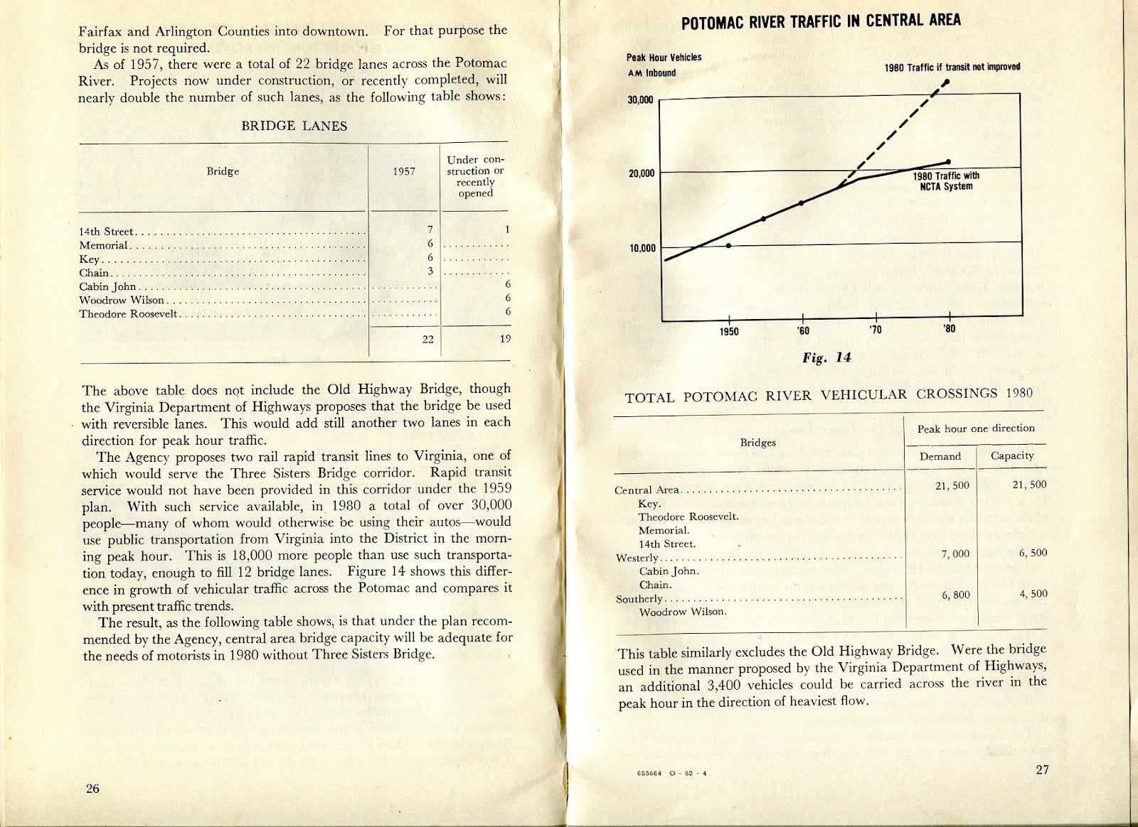
Recommendations for Transportation in the National Capital Region: A Report to the President for transmittal to Congress by the National Capital Transportation Agency November 1, 1962
1959 and 1962 proposed transportation systems
1962 proposed rail transit and freeway Systems
A comprehensive freeway system with a greatly reduced footprint displacing a fraction of the dwellings of that proposed in the 1959 Mass Transportation Plan.
---
excerpted from pages 12-13 (also see pp24-29)
The Relocation Problem
The District of Columbia Highway department estimates that
construction of the interstate highway portion of the 1959 plan would displace some 28,000 persons. The Agency estimates that
construction of all the highways proposed in the 1959 plan, excluding the portions already under construction would displace some 33,000 persons in the District of Columbia alone, or almost five percent of the District's population. In contrast a rapid transit system will be constructed for the most part under the streets or on existing right of way and,
together with the necessary highways, will displace only about one sixth as many persons. Under the 1959 plan there would also be substantial displacement of schools, churches and businesses, to say nothing of the serious disruption of neighborhoods by the construction of highways through heavily built up areas.
The Solution
As a result of its studies the Agency recommends a balanced transportation system composed of:
1. A regional rapid transit system designed to encourage a high degree of utilization of public transportation for trips to and through downtown (Map B page xiii)
2. An expanded highway system complementing the rapid transit system. (Map C, page xiii) This highway system is designed to provide a high level of freeway service to the region while reducing to a minimum problems of relocation, tax loss and impact on the character of the city.
1962 Freeway Plan
narrow lines represent smaller scale parkways or trenched
grade separated "express streets"
excerpted from pp 43-46
Downtown Freeway System
The agency's highway plan includes an inverted "T" within downtown Washington connecting the central bridges with freeways leading to Montgomery and Prince Georges Counties. the "T" includes major elements of the inner loop proposed in the 1959 plan. (Map E). However, the North Leg of the previously proposed loop is replaced by an express street system that would provide adequately for traffic requirements and at the same time preserve desirable neighborhood characteristics and fit in with any future plans for neighborhood improvement. The agency's studies how that such improved street facilities would be adequate for traffic movements in the area which the North leg would serve. The precise design of the system for accommodating such traffic can be worked out through the joint efforts of the Agency and the District of Columbia highway department.
The Agency's studies similarly show that the East Leg of the previously proposed loop is not required since it can be satisfactory replaced by a high speed route through Fort Drive.
[Note: this 1962 report's map shows this as a thick line partially along Eastern Avenue, hence showing it as a 6 or 8 lane freeway like the Inner Loop East Leg, but routed further north, neither along 11th Street NE/SE as proposed in 1955, nor to the east Capitol Street- RFK Stadium area as subsequently planned].
Here again the precise means of routing traffic around the eastern part of the city can be worked out through the joint efforts of the agency and the District Highway department.
Construction of the "T" involves
(a) Extending the Southeast Leg to 11th Street and across the Anacostia River to Route 295; and
(b Constructing an underground freeway below the Mall from Third and C Streets SW to the vicinity of Third and C Streets NW, and a depressed freeway from there to New York Avenue and Florida Avenues. This Third Street leg will not require use of any part of the Capitol grounds. in the vicinity of New Jersey Avenue it will be integrated with proposed urban renewal projects.
The "T" will provide superior access to downtown commercial areas and at the same time will enable substantial numbers of autos and trucks going elsewhere than downtown to bypass the center of the city. The Agency's studies show that each leg of the "T" will carry some 7,000 vehicles in each direction during the peak hour in 1980 at speeds average 20 to 25 mph compared with 10 miles per hour today on existing streets. during the off peak hours, speeds will average 40 miles per hour. as noted in Chapter III, the "T" will substantially relieve downtown street congestion.
Routes 70-S and 95 in the District of Columbia and Maryland
"Significance of Using B&O Route. Use of the
Baltimore & Ohio Railroad corridor to bring Routes 70-S and 95 into the
city is the key to meeting the need for additional highway capacity in northern
Washington, Montgomery County and northwestern Prince Georges Counties and at
the same time avoiding the substantial relocation of persons, loss of taxable
property and disruption of neighborhoods that would result from construction of
the Northeast, North Central and Northwest Freeway proposed in the 1959 plan.
Further savings are realized by placing the rapid transit line to Silver Spring
and Queen’s Chapel in the same railroad corridor."
Route 66 in Virginia
This route is already under construction outside the Capital Beltway, and land acquisition has begun inside the Beltway. Under the Agency's plan, Route 66 will have six lanes except between the Airport Access Road junction and Four Mile Run. Between these two points the capacity will be increased to eight lanes. From Route 66 to Arlington Boulevard, a short spur through Four Mile Run will be needed as will improvements of the Boulevard. it is pointed out in chapter III that because trucks are not permitted to use the Theodore Roosevelt Bridge, a connection with the Shirley Highway bridges will be made via the Jefferson Davis Highway to accommodate route 66 truck movements.
Route 95 in Virginia
The Virginia Department of highways proposes to widen Shirley Highway to a 3-2-3 lane configuration. The middle two lanes will be reversible so that five lanes will be provided in the direction of heavier traffic flow. the Shirley Highway improvements proposed by the Virginia Department of Highways have been incorporated by the Agency's plans. Minor modifications to permit development of express bus service and transfer of bus passengers to the proposed rapid transit lie near the pentagon are presently being discussed with the Department and the bureau of public Roads.
Other Major highway and Street Improvements
For proper operation of the downtown freeway plan, two projects are essential: (a) construction of a highway on Fort Drive between the junctions of routes 95 and 70-S and on Kenilworth Avenue Expressway, and (b) the development of an express street system to replace the proposed North Leg. The Fort Drive route will require only a small amount of new right of way since much of the land has already been reserved for highway purposes. In latter years it will be necessary to widen Kenilworth Avenue and the Anacostia Freeway.
The express street system that would replace the North Leg of the previously proposed Inner Loop system would be connected directly with the downtown freeway system and would in general follow the location of the North Leg route. From the west it would be below grade most of the way to Connecticut Avenue and would be four lanes wide. Between Connecticut Avenue and the junction of Florida and Rhode Island Avenues, the system would be at street level and would be under-passed at several crossings. Between Rhode Island Avenue and New York Avenues the system would again be below grade.
The agency has already made extensive studies of the proposed express street system.
[Note- there is an "S Street Express Street Study Report" that I have seen at the library of the U.S. National Capital Planning Commission for a depressed roadway similar to the depressed segments of North Capital Street].
It proposes to conduct further studies in collaboration with the National Capital Planning Commission and the District Department of highways to work out the precise means of accommodating vehicular traffic in ways most advantageous to the neighborhoods.
In the Bethesda area two major road improvements will be required: (a) grade separating Wisconsin Avenue or nearby parallel streets at key intersections and (b) widening Little Falls Branch Parkway, and connecting it to Wisconsin Avenue and the George Washington Memorial Parkway.
1962 freeways- close up
1962 rail transit plan
The 1962 report had a greatly increased rapid rail system then that proposed in the 1959 report.
1962- rail transit system
1962- downtown rail transit subway system
pp 31-42
The principle features of the express transit system are:
1. Two subway routes crossing twice within downtown to provide an extensive distribution and collection system. This will provide fast service throughout downtown, speeding rush hour trips and improving circulation of downtown traffic in off peak hours
2. Extensions of the downtown system throughout the district and suburban areas via seven rapid rail transit routes and one commuter route.
3. Stations and paring areas, designed to meet the needs of the auto age and to serve as local distributions and collection centers.
4. Express and local bus services in the district and throughout the suburbs with convenient connections to the high speed trains
.
The rail rapid transit system will be 83 miles long and will be served by 65 stations. Nearly 19 miles will be underground. Some 26 miles of freeway median strips and 24 miles of existing railroad right of way will be used for the rail rapid transit system. The Pennsylvania railroad line will be 15 miles log and will have seven suburban stations. Express bus operations will be provided on 52 miles of freeway and parkway.
The Downtown Subway
The downtown subway network is the heart of the regional transit system. The pattern of this central underground system has been guided by existing and potential development of the downtown area, and has been designed to provide convenient connections between all major concentration of downtown activist, including federal and private office and commercial areas. It is essential to unify and strengthen Washington,'s central area and to facilitate travel within this area.
An east west route (see "A" on map) will bring trains from Anacostia and southeastern Prince Georges County into downtown. From the Navel Weapons plant it will proceed to a station at the Capitol with convenient access to the Senate and House Office buildings. Other stations will be located at the Municipal center (judiciary Square) and in the heart of the downtown commercial area at 8th and g, NW . (Old patent Office Building) and at 12th and g Street NW. The stations along G Street will stretch almost continuously from 7th to 13th Streets, with entrances at all major crossings and key commercial and office buildings.
After passing the Treasury and the White House, the east-west route will continue along Pennsylvania Avenue, turn down 21st street, and proceed to Virginia via a tunnel crossing of the Potomac River in the vicinity of Memorial Bridge. Stations will serve the newly developing employment centers at 18th and Pennsylvania Avenue NW, and at 21st and E NW, near the State Department.
A north-south route (see "B" on map) will bring trains into downtown from the northeastern and north central portions of the District and from Montgomery County and northwest Prince Georges County. At Union Station there will be a convenient transfer to the Pennsylvania Railroad commuter service. From Union Station, the north south route will proceed to the Capitol, where there will be a direct transfer to the other route. The north-south route will then proceed into the new employment area near south of the Mall, with stations at 4th and independence s and at the new 10th Street mall redevelopment area near C Street, and one at 12th and G Street NW, where riders can transfer to and from the other route.
The north-south route will then turn westward, with stations at 14th Street and I, NW, and Connecticut and K NW, serving the highest density office development in downtown Washington. From there the route will go to the Northwest and to Columbia Heights with downtown stations at 18th and P NW, adjacent to DuPont Circle, and at 19th and Florida, providing access to the Connecticut Avenue commercial and office area.
Although a major function of he subway will be to distribute rapid transit riders from the outlying residential area, the system has been designed also to provide swift service for trips confined to the downtown area. Trips by subway service between points such as the State Department and Capitol Hill or the Federal Triangle and DuPont circle will be made in a fraction of the time they now take on surface streets. (Figure 16). Still another important function of the downtown subway will be to provide a fast through route for persons crossing the central area. It will thus reduce the number of auto trips through the heart of the city.
Stations
The 14 downtown subway stations have been located so that almost 80% of the persons employed downtown will be less than five minutes walk from a station to their place of employment. (Figure 17).
Each station will have a separate pedestrian level - a mezzanine, located between the street and the train tracks and served by escalators. For the convenience of patrons and in order to lesson congestion on the streets, the mainlines will provide access to several corners at major street intersections. The mezzanines will have space available for concessions, providing additional revenue for the system, and will allow direct underground access to many of the downtown office and commercial buildings.
Because American cities have built few subways in recent years, the Agency's concept of modern subway design has been influenced by systems recently built in Toronto and in a number of European cities, such as Stockholm. Subways in these cities have clean and brightly lit interiors, with architecturally designed surfaces, modern ventilation and air conditioning and a low noise level. Subway stations are designed to minimize walking, just as the service itself is designed to minimize waiting on the platform. Changes in level are accomplished without effort by escalators and other modern mechanical devices. All of these modern architectural and engineering design features will be incorporated in the proposed downtown subway.
Radial Train Route
Eight rail transit lines will be part of, or will connect with the downtown subway system. (Map I). While the precise location of some segments of these lines is still to be determined, there is no question as to the major corridors to be served. In some corridors final determination of route and locations of stations will have to await more extensive engineering studies and further consultations with local officials.
The eight rail lines will extend into the most densely populated areas of the District and the suburbs. the lines have been placed to serve the greatest numbers of people- and thereby to generate as much revenue as possible per dollar of capital outlay, and they have also been planned to minimize costly subway construction outside of the downtown area. Two of the lines will use railroad rights of way and three others will make extensive use of median strips of proposed highways. A sixth line will provide modern commuter service on the existing electrified tracks of the Pennsylvania railroad. On the remaining two lines subway construction has been avoided where it has been possible to do so.
The Agency has had extensive discussions with the railroads concerned; all have indicated their interest in the proposed project and their willingness to cooperate. The agency made a special study of the sue of railroad rights of way either for rapid transit service or for conventional commuter rail service. The conclusions set forth as herein will be explained in an appendix volume:
The eight rail lines are as follows:
1. Northwest Bethesda. A line from Pooks Hill in Montgomery County will pass through the northwest corridor of Bethesda and the District, down Connecticut avenue to Farragut Square and across downtown to the Capitol. for most of the way in the District the line will be tunneled underground.
2. Columbia Heights Pentworth. This relatively short, two mile spur will provide service for most of North Central Washington. The line will be underground most of the way. It will begin near Georgia and New Hampshire Avenues, proceed to Columbia Heights and join the northwest line at 19th and Florida Avenue.
3. Rockville-Silver Spring. Using the right of way of the Baltimore and Ohio railroad, a radial will pass through central Montgomery County, the upper north central portion of Washington, and a portion of northeast Washington. It will go underground at Union Station and lead directly to the Capitol and downtown.
4. Route 95-Queens Chapel. A line on the median strip of Interstate 95 will originate outside the Capital Beltway, pass through northwestern Prince Georges County and join the Rockville line inside the District of Columbia.
5. Bowie County. Modern commuter railroad service will be provided on the Pennsylvania Railroad from bowie through Lanham and Cheverly. All stations will be in Prince Georges County. The service will be fast and frequent. Trains will bring passengers directly to the subway platforms at union station for n easy transfer to all downtown points.
6. Henson Creek-Anacostia. A combined surface and subway line will bring passengers from south-east Prince Georges County and southeast Washington to downtown. A major transfer station in Anacostia near Good hope Road will connect with bus lines serving the corridor between South Capitol Street and Pennsylvania Avenue. After crossing the Anacostia river, the line will lead into the Capitol area and thence downtown.
7. Springfield-Alexandria. This line will use the right of way of the Richmond, Fredericksburg & Potomac Railroad and the Southern Railroad over much of its length. The line will begin in Springfield, and then pass through Alexandria to the Pentagon. It will then proceed under the Potomac into downtown.
8. Route 66-Roslyn. Using the media strip of Interstate 66 in Fairfax County and portions of Arlington, a rapid transit line will provide service from the city of Fairfax through central Fairfax County, East Falls Church and North Arlington. It will join the Springfield line on the Virginia side of the river.
Rapid Transit Service
Service on the rapid transit system will be rapid and frequent. Overall speeds, including station stops, will average between 45 and 50 miles per hour between the suburbs and downtown. Downtown trains will operate a minute and a half apart during the peak hours. Modern, lightweight equipment will be far superior in comfort and performance to that in use on existing domestic rapid transit systems. the vehicles will be quite modern as those usually associated with so-called monorail systems (which the Agency does not propose to use because, among other reasons, of he cost of placing them underground; see chapter V and the Appendix). The vehicles will be attractive to look at and comfortable to ride in; they will be air conditioned and well lighted. In the open, they will run, for the most part, along freeway and railway rights of way; occasionally they will use aerial structures. Modern insulating methods and track construction will keep noise to a minimum.
As shown in figure 18 the system will provide a fast service to downtown from all points in the region. it will be a dramatic improvement over present transportation in both time and comfort. A detailed listing of the new travel times is given in the following table.
Two hypothetical trips serve further to illustrate the revolutionary change in regional travel times that rapid transit service will introduce.
A peak-hour trip from Silver Spring to the Federal Triangle today takes an average of 45 minutes by bus. A rapid transit passenger who drives his car to the station at silver spring will be able to make the same trip in 8 minutes, 38 percent faster than today's bus trip. A feeder bus passenger will be able to make the trip in 33 minutes, 27 percent faster than today's bus times.
Many commuters will continue to use their automobiles from suburban homes to central city work places. Salesmen, doctors and others need the flexibility of personal transportation. But the overwhelming number of daily commuters are routine travelers, interested mainly in travel time comfort, and economy. Satisfying their needs by efficient, modern public transportation is the major step forward toward a more balanced urban transportation system.
Express and Local Bus Service
Express bus service will be developed on several freeways and express parkways. In addition to the new express service, existing local bus service will serve areas not covered by the regional rapid train routes, and new local bus service will be developed to feed the train routes, particularly in newer suburban areas. the express bus routes will include:
George Washington Memorial Parkway. This route will begin along the Potomac River at Cabin John and use the new parkway into the District to downtown.
Suitland Parkway. This line will use the parkway into the district and then transfer all passengers to the Henson Creek train line at Alabama Avenue.
Anacostia-Boiling. this line will serve the Federal installations at the Naval Research Laboratory and at the Anacostia and Boiling facilities and will be connected to the Anacostia station.
Shirley Highway. Frequent service, using the widened Shirley Highway, will be operated between Duke Street- Lincolnia and the Pentagon area. All passengers will transfer to the Springfield train line for quick service downtown.
---
See the full
Recommendations for Transportation in the National Capital Region:
A Report to the President for transmittal to Congress by the National
Capital Transportation Agency November 1, 1962 document here:
http://wwwtripwithinthebeltway.blogspot.com/2012/02/november-1-1962.html
---
This November 1, 1962 report stands in marked contrast to the status quo to come, with its intent was to build BOTH the freeways and the WMATA system.
The popularization of the idea of simply not building a continuous Washington, D.C. freeway system would come in the wake of the October 1964 North Central Freeway report that failed to follow the 1962 report's prescription for that freeway to strictly follow the B&O railroad corridor that runs alongside Catholic University of America.
http://wwwtripwithinthebeltway.blogspot.com/2012/01/crafted-controversy-scuttling-of-jfks-b.html
http://wwwtripwithinthebeltway.blogspot.com/2015/01/feds-stoked-controversy-over-dc.html
In the time since, mainstream media accounts of this history have been overly generalized. They apply criteria against building new urban freeways that is strangely not applied to urban railways; nor do they consider such projects elsewhere from around the world as that in Madrid. Nor is such applied to new real estate development placed so close to existing urban freeways and railways, as to complicate reconstructing such underground to reconnect local neighborhoods, such as with new linear parkland in areas of the city were such is rare. Though, for instance, people in Brookland, D.C. favored a proposal to cover the existing B&O railroad, the whims of Catholic University of America to remain isolated by the existing surface railway would take prominence.
Meanwhile, revisionist accounts by WMATA have presented a differing dichotomy of building the rail transit system or the freeway system, neglecting the history that the two systems were planned to be constructed together.
http://wwwtripwithinthebeltway.blogspot.com/2011/12/wmata-pushing-false-dichotomy-of-them.html
It's as if people were being distracted from asking questions about why a nation as wealthy as the United States of America was somehow too poor to afford building both the rail transit and freeway systems, particularly in the city that happens to be the Nation's Capital.
As an example. just consider the example of failing to question the cancellation of the Westway highway tunnel project in New York City, that would have created acres and acres of new land with permanently taxable new real estate development, just prior to that State embarking upon perhaps its biggest spending spree ever in police enforcement and prison construction for the sinfully wasteful 'drug war'.
Was it any wonder that this either-or mythology on transit and urban freeways was promoted in part by the Tobacco-pharma power house law firm of Covington & Burling?
http://wwwtripwithinthebeltway.blogspot.com/2009/10/ectc-paid-to-riot-via-covington-burling.html
http://wwwtripwithinthebeltway.blogspot.com/2009/12/peter-s-craig-editorial-reply.html
For more on the 'drug war' see my companion blog
'Freedom of Medicine And Diet'
http://freedomofmedicineanddiet.blogspot.com/
Anyone interested in urban planning should be appalled at the tremendous waste of money and lives spent on the 'drug war'.