See comments at:
The only thing that hasn't changed in the
last 40 years in the corridor in question is that nobody wants this highway?! *Nothing* in them is valid
anymore?!-
A baseless claim, regarding a later freeway routing option. One on the books for only a few months in 1973; at the tail end of a crafted controversy against its connecting segment within the District; that itself was relatively uncontroversial, until becoming highly politicized for reasons unrelated to its basic feasibility.
It's the same right of way. The
same topography. Virtually the identical development, with the one main
difference being that eminent domain special development upon the connecting segment
just inside the Distract: the Comstock ‘Hampshire’s’ project. Which
anyone buying into was warned via my blog, so they knew they were buying an
eminent domain demolition special that should have not been approved.
It's a different generation. One that has seen the
fallacy of pretending that WMATA serves as a substitute rather than a supplement
to highways 40years after the wholesale cancellation of
the unbuilt inside the Maryland Beltway freeway system - resulting in some of
the worst traffic problems in the US! One that may be far more skeptical of the whole idea that a nation as rich as the U.S.somehow HAD to de-map the freeway system to fund the WMATA system- particularly given the 100s of billions squandered in the drug war. And one that may be aware of more innovative urban highway projects elsewhere done right to blend into the urban fabric in a more benign indeed complimentary fashion from Boston, Massachusetts, to Madrid, Spain. In a state where highway expansion - dualizations and grade separations - have been derided as a simple means to fund what may be worthy transit projects - the Maryland election of a new Governor with votes from areas acknowledged as favoring better highways and questioned the simple prioritization of transit at the expense of highways may portend a change, perhaps on a broader scale: that perhaps we should re-think certain transit projects, either defer them, or at least work out some better financing from the new development that would rely upon them, to lessen the financial burden on official budgets in areas that have not simply deferred highway projects, but rather pretended that such should never be built.
Also,
completing an unwanted plan is pretty much the worst justification for a
project ever. I am completely aware of what these old studies were advocating.
They were widely rejected for a host of reasons.
Unwanted by who, what, and
why?
http://wwwtripwithinthebeltway.blogspot.com/2007/02/sampling-of-attitudes-towards-dc-i-95.html
The PEPCO I-95 extension plan was
the result of popular sentiment against the longstanding plan, from the 1950s
to February 1973 for the inside the Beltway I-95 extension via Northwest Branch
Park routing. That plan would have taken about
100 acres of parkland along a stream, plus about 110 residences in Maryland,
entering the District via the Fort Drive right of way, taking 0 homes there between
Gallatin and Galloway Streets- and was opposed within Maryland for the parkland
stream corridor impacts. The PEPCO I-95 alternative
first appears only in the 1971 Deleuw, Cather, Weese study, and was written up
highly favorably for using an existing non stream corridor 250 foot wide
clear-cut, so noting the feasibility of re-aligning the power-lines, including
the option of burying them, and the superior geometry of the new Hampshire Avenue
corridor extension connecting with North Capitol Street and Missouri Avenue
providing better serviceability access into the north-south and east west street
grid into northern Washington DC.
I ask
yet again, what travel demand would this project satisfy? That couldn't be
addressed with widening 295? Where will all these cars park? Why should
thriving neighborhoods be destroyed to save a guy from Columbia a few minutes
commuting time?
Service into, and for northern Washington, D.C. as well as through traffic. Widening I-295 (and hopefully modernizing it with full shoulders and some cut and cover tunnels as local mitigation) can serve the latter but not the former. To go through SE to get to NE or NW? Why must traffic go way out of its way through a poorer area that still awaits mitigation, while dismissing largely cut and cover existing right of way links into wealthier areas?
Neighborhood destruction? It’s almost entirely existing
right of way. But for the final 1600 feet between its
southern end and the District line, the PEPCO right of way is all of the 5.3
mile length from the beltway to the District line, with that final stretch consisting
of retail strip properties. What neighborhoods,
asides from a portion of such along the north side of New Hampshire Avenue, primarily along a less than one block segment of Eastern and Rittenhouse, consisting of only 27 mid 1900s brick houses within the next 1,600 foot extension between the Maryland-District line and the B&O corridor. Oh yes, the brand new Comstock town-house project ‘The Hampshires’ just erected in the past two years- based upon purjurous testimony by USNCPC that did not even mention the transportation corridor significance- consisting of 110 new dwellings- with inhabitants that should have known about from this blog by simply doing an internet search upon what they were buying into. Whether the figure is 27 or 27 plus the bulk of that Comstock eminent domain special, the figure is a low number to connect a some 5 mile
right of way with that railroad industrial corridor that only requires
another 30 or so for a total of 59 for the entire highway from the Beltway to the confluence of the B&O and New York Avenue- plus whatever is now being built looking to make a quick profit off
of new dwellings that should have never been approved.
I
don't understand the hostility you have for the neighborhoods and institutions
that have been in place for over 100 years. Why should anyone consider
displacing CUA for a highway?
What hostility for
neighborhoods in general? I have written that I oppose
the earlier plans such as I-66 via a new swath through thousands of dwellings
along Florida Avenue and U Street, and versions of the North central freeway
likewise along Georgia Avenue, along with the infamous 1964 routing on a longer
route away from the railroad through Takoma Park in 1964. And I have written not to simply revive the
plans as evolved radically from the 1950s to the 1970s- compare the 1950s version
of the I-66 North leg and the replacement K Street Tunnel plans as an example- but rather take the
design evolution further to reduce impacts and improve operation-ability – such as
connections between the proposed K Street Tunnel and the effective center leg
extension to the northeast, relocating cut and cover tunnel segments respectively
partially and fully alongside New York Avenue displacing 148 and 600+ (or
rather 550+ as Mayor Anthony Williams tore some down about 15 years ago) to respectively
entirely under the avenue taking 0 for an independent continuation of the I-66
tunnel, and as few as 33 for I-395 (I-95) with a tunnel arcing beneath the
intersection of new jersey Avenue and N Street transitioning to a double deck configuration
beneath O street, providing a 95% reduction in displacement with a
gentler-superior transition radii- vital in a curved tunnel segment.
See: http://wwwtripwithinthebeltway.blogspot.com/2007/11/i-395-extension-superior-option.html
Nonetheless that alternative has gone
entirely unconsidered in the 1996+ Ron Linton I-395 tunnel extension planning
despite its inferior geometry. If anyone is being hostile, it is your position with regard to SE of the Anacostia.
Not institutions but rather
institution.
It was JFK that radically
reshaped the transportation planning after the 1959 Mass Transportation Plan,
greatly increasing the proposed rail transit system and significantly reducing but
not eliminating the proposed freeway system to greatly reduce the impacts.
A main point of that was the reduction of three separate northern freeways with a
single 2 into 1 “Y” route via the route with the least impact from the November
1962 report:
"Significance of Using B&O Route. Use of the
Baltimore & Ohio Railroad corridor to bring Routes 70-S and 95 into the
city is the key to meeting the need for additional highway capacity in northern
Washington, Montgomery County and northwestern Prince Georges Counties and at
the same time avoiding the substantial relocation of persons, loss of taxable
property and disruption of neighborhoods that would result from construction of
the Northeast, North Central and Northwest Freeway proposed in the 1959 plan.
Further savings are realized by placing the rapid transit line to Silver Spring
and Queen’s Chapel in the same railroad corridor."
1962 B&O Route
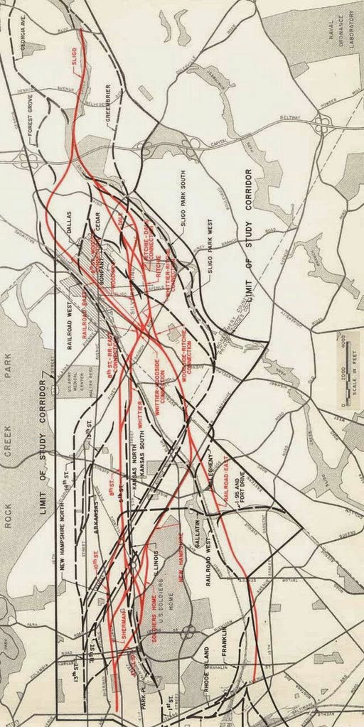
with I-95 routed from the northeast via the Fort Drive routing
connecting with that via Northwest branch in Maryland
That was a key point. A study report on this was due sometime in
the summer of 1963. JFK and his wife
meanwhile had an interest in urban planning; and he was likely aware of that at
that time for the proposed Boston Inner Belt which featured proposed designs
for partially encased box tunnel segments beneath new pedestrian promenades. As JFK was from Boston and undoubtedly
somewhat familiar with that area along with that alongside Catholic University
of America (where the road there today is named after the 1962-1971 Speaker of the
House, John William McCormick), I can wonder if he ever envisioned a design like that for alongside
CUA.
1963 Boston Inner Belt: park atop highway tunnel segment
1965 Boston Inner Belt: park atop highway tunnel segment
1966 D.C. I-95 North Central Freeway with cover alongside Catholic University of America
John W. McCormack
Then see what happened in
1967 after the controversy had died down only to be again inflamed by the then
new UFHWA waffling between the infinity less opposed 1962/1966 planning and the
infamous 1964 planning, as explained by this June 1, 1967 letter from Takoma Park resident Duncan Wall to
Maryland Governor Spiro Agnew:
Citizens of Takoma Park and Silver Spring had reason for
their demonstrations of bitter dissatisfaction with the highway authorities of
your predecessor's administration. After we had been given reason to believe
that the causes of our protests had been in at least some part overcome, the
matter now threatens to break into renewed bitterness. I am sure you will wish
to avoid this as much as many of us.
We showed that the methods of traffic projections which were claimed to
justify the North Central were fallacious, the results in error by as much as
400 percent. Our contention was tacitly admitted in "re-studied"
versions of the proposal made public last year, sharply reducing the original
plan of 5 lanes each way.
The re-studied proposal also tacitly admitted that the route first proposed
was needlessly, even carelessly if not ruthlessly, destructive of our
communities. The new version hugged both sides of the existing Baltimore and
Ohio railway, thus avoiding a new swath of destruction to divide our
communities and sharply reducing the number of homes to be taken.
The reduced, re-routed proposal was made public last year with endorsement
of D.C. And Maryland highway authorities. The D.C. Portion was forced through
the National Capital Planning Commission by votes of representatives of the
D.C. Highway Department and of the U.S. Bureau of Public Roads. From this we
concluded, reasonably enough, that the highway authorities of the two
jurisdictions (Maryland and D.C.) had reached a firm understanding with the
Bureau of Public Roads.
Many of us were therefore astonished and aroused to preparations for renewed
protests when Washington newspapers recently reported that the Bureau has acted
to open it all up again. We have not found the Bureau forthcoming with candid
information, but the press articles intimate an intention to force Maryland to
accept modifications of route or design ostensibly "cheaper."
The result is that the whole controversy, which had been somewhat quiescent,
is beginning to agitate the communities again. I can assure you this is so, for
although I recently resigned chairmanship of the Metropolitan Citizens Council
for Rapid Transit and write this simply as an individual citizen who wishes
your administration well, I do remain in close touch with neighborhood
sentiment on transportation-related issues.
Now- why would the planning so disregard that key point of the 1962 JFK plan?
Such inflaming of opposition
would be sufficient for two main entities necessary for approving the highway
to reverse their long standing support for the freeway by the end of 1968. Thus, what we have was a manufactured opposition, to a freeway that had previously been not very controversial.
Now which entity holding which property
alongside the B&O route would be that with the motive and the ability to
bring these events about, particularly for something that JFK had endorsed a
year prior to his assassination and which was clearly botched and scuttled in the
following years?
To see more history about
the manipulation of the planning, see:
Consider the time-line, as
well as the history of that medievalist entity, particularly its manipulations
on a greater scale; see:
It is notable that manipulation
of public opinion regarding DC I-95 is never mentioned as a possible motive for
what happened to the last U.S. President to show such an interest in urban
planning; perhaps that is why his best known quote remains: ask not what your
country can do for you, ask what you can do for your country. No I never said that CUA should be displaced
by a highway- instead it would run alongside in a cut and cover tunnel. But given the histories, perhaps that charge
of yours is some sort of Freudian slip of how the public would feel if they knew
the hidden story? Notably have we yet since had a U.S. President show such an interest in urban planning?
Do
you have any idea what it would cost to put a highway and a railroad
underground through DC? My offhand guess is that rebuilding the corridor in the
manner you describe would cost upward of $20 billion. Likely more.
Perhaps, perhaps not. But the benefit would be immense. Not only would there be this highly useful
highway for regional travel, additional highway benefits for locals with some
extra ideas not included in any of the earlier planning- such as new linear
surface roadways flanking the new linear park from Union Station northwards,
plus a 410 East West Highway bypass around Takoma Park, via a set of lanes from
where EWH crossing the PEPCO corridor southward and then northward along the
B&O to a set of center loader tunnel ramps emerging past Georgia Avenue.
Center loader ramps are an atypical design
that I have seen only with the redesign of the southbound I-395 Center Leg on ramp with the current “Capitol
Crossing” air rights project. Center
loader means that the access ramp to or from a freeway ramp is towards the
center rather than off to one side of a surface street. This eliminates the freeway related traffic
conflict with pedestrians and cyclists by routing this heavy traffic towards
the center of a road. See:
I also take it that you've not been to NE
any time recently. Do you live in DC? Or the region, at least? If not, I have
nothing more to say to you than the following:
1. I certainly agree that DC being
treated as a fiefdom (by Congress) is tiring. Maybe you should refocus your
blog to advocating for DC Statehood so the District has true homerule. Or maybe
you should just refocus your fantasies on wherever it is that you live. DC
doesn't need you.
2. Whatever you do, don't quit your day job to become a highway engineer or
transportation planner. You wouldn't last long, at least not in this century.
I'm glad your hobby keeps you busy, though.
I first visited DC as an
infant but my earliest memory is a family trip in 1972 when I first saw the
I-95 stubs and was told by a hotel bellhop that was over opposition to ‘white mans
road through black mans homes’ and found myself wondering about that wide power-line
right of way: an early lesson about the intoxicating effects of simple slogans.
I lived in the area from
1991 to 2004. I last visited the area in 2013.
You may see some of my
highway planning efforts at this blog’s tag about the “Alexandria Orb” - designed to mitigate the effects of the de-mapping of DC I-95's impacts upon an area consequently receiving far more traffic- where I saw U.S. NCPC which adheres to that de-mapping turn their back, much like they do with the neighborhoods along the Anacostia Freeway in SE.
What happened with the scuttling of the JFK B&O D.C. I-95 and the South Capital Mall speaks volumes of the true nature of this fiefdom.
By the way you failed to answer my previous question- are you connected with WMATA?
There's a WMATA Financial Officer with your name- Tim Winslow.
http://www.zoominfo.com/p/Tim-Winslow/1973554138
https://www.linkedin.com/in/twinslow
Both educated at St. John's.
If that's you, perhaps you shall be the one who ultimately signs the checks paying back the funds that were transferred during the 1970s?









What was the vote? Was it unanimous or was their some diversity of opinion, debate??
by Douglas Willinger on Mar 3, 2009 11:34 am
by David Alpert on Mar 3, 2009 11:41 am