Was the result of a report which studied 7 possible alignments for I-95 in D.C. NE.
While controversy swarmed around the plans for the I-70S Northwest Freeway, the first officially commissioned consultants engineering report for the D.C. I-95 Northeast Freeway concluded with the June 1960 release of: A Report on location: The Northeast Freeway, Washington, D.C., June 1960 Prepared fot the Board of Commissioners by The Clarkeson Engineering Co., Inc., Consulting Engineers, Inc. Boston, Albany and Washington, and the District of Columbia Department of Highways. This report was issued in conjunction with the Board of Commissioners, District of Columbia, Robert E. McLaughlin, President, David B. Karrick, Commissioner, Alvin C. Welling, Engineering Commissioner, Brigadier General, Corps of Engineers, U.S.A.; Department of Highways, District of Columbia, H.L. Aitken, Director, and the Bureau of Public Roads, U.S. Department of Commerce.
These 1960 plans provided for an 8 lane I-95, with 10 foot right hand shoulders. In accordance with the general transportation planning, this included a version with an extra wide (64 foot) median for future use, either as reversible express lanes for autos and buses (as seen on the I-395 Shirley Highway in northern Virginia), as a two way bus way, as a double track rail transit, or "a new form of rapid transportation, not yet foreseen, in place of conventional rail equipment."
Fast Facts:
- 4.14 miles D.C.
- $73.961,400 D.C.
- 8 lanes
- Design Speed: 50 mph DC,
- Max. Horizontal Curv. 3 degrees
- Max. Grade: 3%
- Min. vert. clearance: 14'-6" DC
Gross Displacement: D.C.
- Dwelling Units: 1095
- Business: 51
- Industrial: 39

Eastern:
Route A: Entering D.C. due south along the west side of 24th Street NE,, turning southwesterly to parallel New York Avenue railroad corridor for about 2/3erds of a mile, before turning south leaving said railroad corridor crossing over Kendall Street, to cross West Virginia Avenue to meet its southernmost segment along Montecello Avenue, to meet the Inner Loop at Florida Avenue and 11th Street.
Route B: Entering D.C. upon southwesterly alignment at North Woodridge that would immediately turn due south along the west side of 22nd Street NE, crossing to its east side at Rhode Island Avenue, before turning south/southwesterly at Evants Street to cross New York Avenue railroad corridor at 16th Street NE to axis atop West Virginia Avenue to southernmost segment along Montello Avenue, to meet the Inner Loop at Florida Avenue and 11th Street.
Central:
Route C: Entering D.C. approximately 1/4 mile east of the intersection of Sargent Road and Gallatin Street NE upon southwesterly alignment crossing beneath intersection of Sargent Road and South Dakota Avenue before turning south/southeasterly to parallel east side of the Metropolitan Branch B&O railroad corridor, leaving railroad corridor at Monroe Street to run along west side of 12th Street NE to Rhode Island Avenue to shift to axis just east of 12th Street to cross railroad corridor to routing over Kendall Street, to cross West Virginia Avenue to meet its southernmost segment along Montello Avenue, to meet the Inner Loop at Florida Avenue and 11th Street.
Route D: Entering D.C. Approximately 1/4 mile east of the intersection of Sargent Road and Gallatin Street NE upon southwesterly alignment crossing beneath intersection of Sargent Road and South Dakota Avenue before turning south/southeasterly to parallel west side of the Metropolitan Branch B&O railroad corridor, crossing east of railroad at Monroe Street to run along west side of 12th Street NE to Rhode Island Avenue to shift to axis just east of 12th Street to cross railroad corridor to routing over Kendall Street, to cross West Virginia Avenue to meet its southernmost segment along Montello Avenue, to meet the Inner Loop at Florida Avenue and 11th Street.
Route E: Entering D.C. Approximately 1/4 mile east of the intersection of Sargent Road and Gallatin Street NE upon southwesterly alignment crossing beneath intersection of Sargent Road and South Dakota Avenue before turning south/southeasterly to parallel west side of the Metropolitan Branch B&O railroad corridor, crossing east of rail at Rhode Island Avenue, to cross New York Avenue railroad corridor to routing over Kendall Street to cross West Virginia Avenue to meet its southernmost segment along Montello Avenue, to meet the Inner Loop at Florida Avenue and 11th Street.
Western:
Route F: Entering D.C. Approximately 1/4 mile east of the intersection of Sargent Road and Gallatin Street NE upon southwesterly alignment crossing beneath intersection of Sargent Road and South Dakota Avenue, continuing west/southwesterly east of Metropolitan Branch B&O railroad to enter a 4200 foot long bored tunnel segment crossing beneath Soldier's Home, before turning due south to follow east side of Sherman Avenue for its southernmost approach to the Inner Loop at Sherman Avenue and U Street.
Route G: Entering D.C. between Gallatin and Galloway Streets, immediately crossing Gallatan Street, to run through residences parallel to its south side for an westerly alignment crossing west of the Metropolitan Branch B&O railroad to run parallel to south side of Hamilton Street before tuning southwesterly to follow east side of Kansas Avenue. This route would have continued alongside Kansas Avenue for approximately one mile before turning due south to follow east side of Sherman Avenue for its southernmost approach to the Inner Loop at Sherman Avenue and U Street.
1. Design Speed Desired Attained A. Freeway 50 mph 55 mph B. Ramps 25 mph 25 mph 2. Alignment A. Horizontal Curvature (1) Freeway (minimum) 3 degrees 3 degrees (2) Ramps (minimum radius) 150 feet 150 feet B. Vertical (1) Freeway (Maximum Grade) 3% 2.8% (Minimum Grade) 0.5% 0.5% (2) Ramps (Maximum Grade) 6% 6% (Minimum Grade) 0.5% 0.5% C. Sight Distance Freeway (Minimum Stopping Distance) 350 feet 440 feet 3. Roadway and Median Width A. Freeway (1) Lane width 12 feet 12 feet (2) Median width 7 feet min. 7 feet (3) Paved Outside Shoulder 10 feet 10 feet B. Ramps (as proposed by A.A.S.H.O. design policy)
4. Structures A. Design Loads + H2) - S16 (44) including military requirement of the Interstate System B. Minimum Vertical Clearances (1) All Freeway Structures 14 1/2 feet (2) Over Electric Railroads 26 feet (3) Over other Railroads 23 feet
Route Options:
East to West
Route A Route B Route C
The Recommended Route
Route D Route E Route F Route G Length: (miles) 3.59 3.47 4.14 4.34 4.30 3.64 4.33 Construction Costs (w/64 foot median) $45,436,000 $40,133,600 $43,139,100 $53,624,500 $45,828,500 $88,632,400 $41,942,200 Right of Way Costs $23,575,000 $20,948,300 $30,822,300 $30,226,100 $22,676,500 $36,118,300 $48,879,000 Total $69,011,000 $61,081,900 $73,961,400 $83,850,600 $68,505,000 $124,750,700 $90,821,200 Property Takings: Residential 792 732 1,095 1,117 922 1,540 1,973 Commercial 50 55 51 52 34 100 103 Industrial 34 13 39 26 9 11 11 Churches 2 2 1 1 1 4 5 Schools
0 0 0 0 0 1 2 Other 0 1 1 0 0 1 1 Apartments
109 79 103 102 112 68 155 Vehicles Served 69,000 58,500 108,860 101,330 89,170 ** ** Cost/Vehicles served $1,000 $790 $680 $827 $768 ** ** Special Notes: Included 4,100 foot long bored tunnel segment beneath Soldier's Home
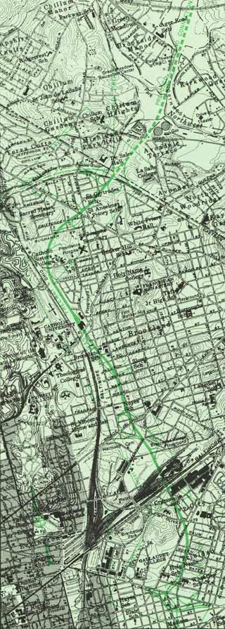
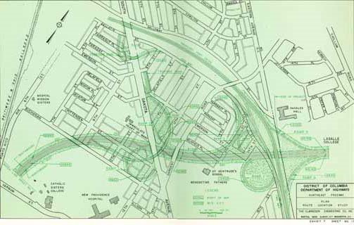
Of these 6 options, the June, 1960 I-95 Northeast Freeway study recommended in favor of the latter route that ran along the B&O railroad. It rejected both the routes along Sherman Avenue and in eastern Brookland because of the formers' conflict with the proposed North Central Freeway (which was then being proposed upon its own alignment in the area between Rock Creek Park, eastwards to Soldiers Home, roughly along the Georgia Avenue corridor), and the latter's disruption to stable neighborhoods by the introduction of a new local separation. It thus settled upon the idea of routing I-95 generally along the existing B&O railroad corridor- that is alongside the railroad and even the railside industrial corridor, so as to build upon the existing separation of land uses. It however, rejected a route along the west side of the B&O railroad, so as to avoid disturbing Catholic University's easternmost edge, selecting instead a route to the east of the railroad through western Brookland neighborhoods south of Michigan and Monroe Streets and west of 10th Street, requiring the removal of historic Brooks Mansion.
 Enters D.C. from Northwest Branch Park in Maryland with southwesterly alignment at Catholic Sisters
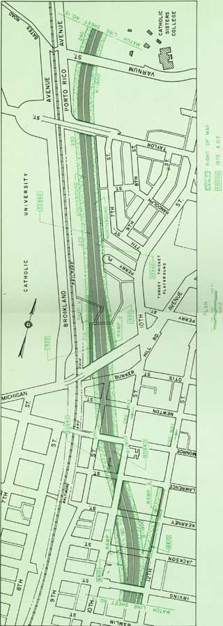 Runs parallel east to B&O RR to Taylor Street through industrial properties southward to Michigan Avenue, before swinging away from RR directly through Brooks Mansion, before running west parallel to 11th Street NE
 Runs west parallel to 11th Street NE as depressed freeway, crossing beneath Rhode Island Avenue, before rising upon a viaduct to cross over New York Avenue
 Viaduct continues southward to an elevated berm section west parallel to Montello Place to elevated interchange with elevated North Leg along Florida Avenue, and depressed East Leg along 11th Street NE/SE.
 This 1960 I-95 route could feed directly into the I-295 East Leg along 11th Street NE/SE.


No comments:
Post a Comment