Saturday, March 03, 2007

How Things Went at the U.S. National Capital Planning Commission: November 1, 2001

I was not alone in my pleas at the November meeting, where I was joined by Alexandria resident Ed Ford. He had purchased and moved into the southern-most house along the east side of St. Asplund Street which ends at the St. Mary’s graveyard immediately next to the Capital Beltway ascent to the bridge. Mr. Ford, having seen the urban deck plans covering this area of the Beltway alongside his house, relied upon these plans in making his offer to purchase that house, prior to the changes in planning. The reduction in the deck would reduce his property’s anticipated value. Having looked for support from various entities in Alexandria that one might think might be helpful, Mr. Ford was quite pessimistic. He hoped to do better before the N.C.P.C., which had worked to increase the traffic on the Beltway by Mr. Ford's neighborhood by canceling I-95 through Washington, D.C., and hence should not turn their backs upon Mr. Ford's neighborhood's plight.

Both of us spoke before N.C.P.C. Mr. Ford was polite enough to note to the N.C.P.C. that he was speaking for his neighborhood, and that they saw no need to bother the N.C.P.C. with a lengthy list of speakers.

But N.C.P.C. would certainly turn their backs upon Mr. Ford's neighborhood, especially N.C.P.C. member Richard L. Friedman (appointed by the preceding U.S. President Clinton whose term ended January 20, 2001), who was anxious to end our pleas. He seemed quite uninterested and unconcerned about our interests and concerns. He moved to end discussion and vote, which they did.

Like before none voted against the deck reduction; but unlike before we got one abstention, the D.C. delegate, Ellen McCarthy.

http://www.committeeof100.net/pdf/test/McCarthytestimony.pdf

I dropped off about 25 or 30 of my Orb “See and Compare” buttons that inspired The Alexandria/Fairfax Journal’s December 18, 2000 page one coverage for each of N.C.P.C.’s members. I figured I would hear back from some, but I heard back from not even a single one.

How about extending Washington, D.C.'s monumental core beauty to a portion of the Capital Beltway? Nah, just block off the southern waterfront instead.

That's some N.C.P.C..

An Example For the U.S. National Capital Planning Commission: Dream Ahead to 2023 -- live, work, play atop I-405

Since the concept of a covered highway provides a more multi-dimensional use of land for benefiting more people, I attached this example to my statement above to the United States National Capital Planning Commission:

Visions for putting a roof over the freeway and reclaiming 26 Portland blocks will be presented today to a convention of landscape architects

Monday, October 5 1998

By Janet Christ of The Oregonian staff

In this city of visioning, dreaming and imagination, we are being asked to imagine yet again.

To project ourselves 25 years ahead in Portland and live in what is now freeway airspace.

By then, a swath of air through the west side may be transformed into 26 reclaimed city blocks.

Think of a brilliant West Burnside "bright lights" district, a pedestrian and cycling crossing that defies weaving freeway pasta below and a southern traffic connection that brings sense to six roads at the top of Southwest Broadway.

These are among a group of detailed visions for putting a roof over much of the Interstate 405 freeway and creating new land for city life.

Mayor Vera Katz will present the concepts today at the Oregon Convention Center where the American Society of Landscape Architects is having its annual meeting.

Sparked by Katz's February address to the city that promoted reconnecting neighborhoods split by the freeway, the architects' Oregon chapter took on designing the air above the 38-block-long ditch as a gift to Portland, the society's 1998 conference host.

With information from public workshops and sessions this summer, designers added their ideas and created a 20-foot model and sketches.

Paul Morris of McKeever/Morris Inc., a Portland planning and design firm, said the free six-month study is worth about $200,000 in work from the team of 30 design, planning and engineering professionals. It is one of three community-assistance team projects donated.

Katz said the City Council will be asked to approve a final concept plan in late November. And that she really does expect to see it happen.

Knowing what the development, engineering and even air rights costs are for such a mammoth project is still a ways off. At this point, when capping the freeway has not even been approved, no specific means of financing has surfaced.

"We must conduct a thorough economic analysis related to cost and market conditions and determine the level of interest of private sector investment, the mayor said, claiming that the value of freeway air space will increase greatly during the next 25 years with a rising population.

As one example, the architects study estimates a tax income of $625,429 based on a proposed section of 195,000 square feet of commercial space in the west end.

Katz also sees the project fitting well with regional plans for the next 25 years of life in the central city. The freeway lid concept came up in the 1988 Central City Plan. It is a way, the mayor said, to allow density within the urban growth boundary while taking the pressure off neighborhoods that prefer the current quality of life.

Morris said projections are that the 26 reclaimed city blocks will include six acres for parks and recreation,1,000 housing units, 50,000 square feet for civic and exhibition space, 650,000 square feet of commercial space, 1,800 permanent jobs and 2,200 parking spaces for existing needs and future demand. "It's a series of sutures. It's like we're healing," Morris said. The freeway divided the west side for 3.6 miles from Northwest Glisan Street to Southwest Fourth Avenue at Portland State University, clearing homesand stores that sustained largely Italian and Jewish communities.

Katz, who came to Portland the year before propertieswere condemned and the ditch dug in 1965, said reconnecting the streets is overdue and that pedestrians no longer should suffer inhumane walks on freeway overpasses.

Starting in the Northwest Pearl District, the concept map offers a three-block sports and recreation center with grocery store and commercial space on the ground floor and a covered soccer field on the top story.

Going south, people come into the bright lights entertainment district, which Morris describes as a Times Square. It includes a plaza surrounded by cafes, restaurants, night clubs, shops, offices, housing and parking. The site also is the doorway into the downtown business district

Much of the pedestrian routes are covered, so rain won't alter walking plans

Continuing, the concept shows office and retail blocks -- a mixed-use area to complement the light-rail system on Southwest Yamhill and Morrison streets. Main Street Plaza comes up next, three blocks connecting the Cultural District and PSU with Goose Hollow and Lincoln High School. Next to the Great Lawn -- more than a block of green open space -- looms high-rise housing.

More retail space, a civic and office center and high-end condominiums with scenic views are next in line.

And then comes the interchange of Interstates 5 and 405 -- the city's western portal -- dwarfed by an arched crossing for walking or biking. Along this section, freeway slopes are landscaped and terraced to capture stormwater.

Near the university, a new market square is created with four blocks of housing and plaza. It's a new neighborhood center, Morris said. And where the South Park Blocks just end beyond the university campus, a new events space is created, and more student housing rises.

At the south end -- or entrance -- of the project, a round-about connects six roads in a traffic circle whose center is open over the freeway. The nearby developments follow the design, arching toward the circle.

The capped blocks will stimulate other development and activity, radiating toward either side, Morris said. A13-block capping project in Duluth, Minn., finished five years ago, stimulated nearly $1 billion in private development for that city, he said. Building it cost about $220 million.

"Developers have personally told me that capping the freeway will lead to the redevelopment of many underutilized parcels bordering the freeway," Katz said.

But where to begin? Morris said that when public groups looked at specific sections along the freeways path, and when separate groups of architects and developers also were asked to pinpoint crucial sites, all three groups fingered the same top two ideas in the west end: the Civic Stadium areas mixed-use blocks by light rail, and the bright lights entertainment center.

Douglas Willinger Comments to U.S. National Capital Planning Commission: March 1, 2001

Woodrow Wilson Bridge Project

The 11th hour Betrayal of the Promise of the Urban Deck

Humanize Highways, or simply pushing the problem away

Douglas A. Willinger

Takoma Park Highway Design Studio

DO NOT SANCTION 11th HOUR BACK-ROOM POLITICAL DEAL TO “TRADE AWAY” ENVIRONMENTAL MITIGATION LONG PROMISED TO NEIGHBORHOODS NEAREST TO HIGHWAY FOR POLITICAL WISH LIST OF PROJECTS ELSEWHERE HAVING LITTLE TO NOTHING TO DO WITH MITIGATION.

IDEA OF SHORTENING THE URBAN DECK WAS OVERWHELMINGLY REJECTED BY CITIZEN”S SPP ON AUGUST 26, 2000. Planning officials had to bypass citizen’s Stakeholders Participants Panel in planning new reduced deck proposals, during 12-14 period when no such SPP meetings were held from May 1999 to August 2000.

For noise abatement and hence preserving the quality of life fro neighborhoods nearest to I-495, the Urban Deck must extend fully east of Hunting Towers, as did the original 1994 design which predated the 1995-1999 1,100 fott design and the late 1999 700 foot “amended: design.

DELETING DECK AS REQUESTED BY OFFICIALS IN VIRGINIA WOULD PAY HOMAGE TO STYE OF HIGHWAY PLANNING WITH INSUFFICENT REGARD TO NEIGHBORS IN BUILT UP AREAS. People in Washington, D.C. stopped that sort of highway planning over 30 years ago; why should the N.C.P.C. then sanction the taking away of envirnental mitigation at 11th hour?

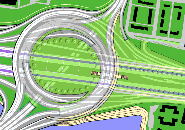
IDEALLY, ADAPT the citizen’s alternative design proposal, so incorporating the Route 1 interchange with the Urban Deck, ALEXANDRIA ORB.

(seen at www.HighwaysAndCommunities.com)

Roughly 25 years ago, with planning stopped for the remaining 2/3erds of the highway network planned for D.C. and inside the Beltway in Maryland, this included abandoning any and all plans for I-95 into and through Washington D.C., leaving its Center Leg, what we now call the I-395 3rd Street Tunnel truncated about 3 blocks from two major railway corridors to the north and to the east Instead, the 1970s solution to the matter of D.C. and I-95 was to re-sign the Capital Beltway between the I-95 interchanges in Greenbelt (with its truncated roadways pointing southerly) and Springfield, as I-495/”I-95” including about 2 expansion joints worth of the Woodrow Wilson Bridge that pass through D.C.’s extreme southern tip. By the 1990s, this was followed with planning for what we are about to embark upon, the Woodrow Wilson Bridge Replacement Project widening the bridge and with it, whether segmented or at once, widening that portion of the Beltway, in order to accommodate a level of service for more than 220,000 vehicles daily.

As environmental mitigation for this road widening project, with its improved ramps and new roadway configuration of a pair of barrier separated carriage-ways in each direction, much like the 12-14 lane New Jersey Turnpike in Newark, or South Chicago’s 14 lane Dan Ryan Expressway -- planning officials from near the start included the Washington Street Urban Deck. Known in the western U.S. as a “Freeway Lid”, this would deck or cover over a portion of the Capital Beltway approach in southern Old Town Alexandria, immediately alongside the neighborhoods of Hunting Towers, Hunting Terrace and Church Street, as well as the historic sites of Freedman’s and St. Mary’s Cemeteries, where an upwards of 17 lanes of highway and ramps would rise/descend to meet the new spans This freeway lid or urban deck would cover over this area of the Capital Beltway, providing sound proofing, and a physical reconnect to tie area back together. Indeed, concerted citizen effort elsewhere has led to their adaptation to numerous highway projects, including I-10 in downtown Phoniex, Arizona, and I-90 in East Seattle and Mercer Island, Washington State, and preliminary planning has already begun for future projects such as capping I-405 in Portland, Oregon.

As always promised and shown as an integral part of the Wilson Bridge Project since the mid 1990s, this cover was to extend from its canted western edge from Alfred Street to just east of the nearest wing of the nearest surviving Hunting Tower, for a distance of about 1,100 feet, though originally it would have extended fully past Hunting Towers (by an additional 100-150 feet easterly), bringing it to 1,200-1,250 feet, providing a multiple-purpose of a sloped viewing platform of Jones Point Park, and the Potomac, and critically needed sound abatement at the 8 story high Hunting apartment towers as close as 15-25 feet from the 12-17 lanes of highway. As noise travels upwards and simple vertical sound walls ineffective in said context, the situation of Hunting Towers is particularly unique in requiring the more effective sound control of a full highway cover. Despite its shortcomings for the easternmost wing of the nearest Hunting Tower, this 1,100 foot design was promised since before during and after selection process, culminating in the September 1996 decision for a pair of 6 lane drawbridge spans. To facilitate citizen input, Stakeholders’ Participants Panels were established, including one for the Route 1 interchange and the Urban Deck, with meetings held regularly up to Spring, 1999, with a 14 month hiatus, with no additional meetings until August 26, 2000.

It would be during this 15-16 month hiatus that project officials, without the advice, consent or even necessarily the knowledge of the Route 1 Interchange/Urban Deck SPP, would hack away about 80% of the Urban Deck’s traditional length, taking it from 1,100 feet, to 700 feet at the end of the EIS process, and then to a mere 200 wide overpass, after the end of the EIS process, and all 3 years after the selection of the 12 lane drawbridge crossing,

The 700 foot design would first publicly appear in the December 22, 1999 Draft EIS. That document would show this “amended” design, deleting decking reducing length from 1,100 to 700 feet, leaving nearest-most Hunting Tower completely exposed to 14-16 lanes of Beltway approach. No SPP panel is ever called to comment upon this new proposal, nor was a SPP meeting ever called for introducing the 700 foot design., despite its clearly far greater environmental impact upon the eastern Hunting Tower.

The 200 foot design (actually two: a curved “Greetings” concept, and a smaller straight-edged “Streetscape”) would first publicly appear in late summer, 2000, with a set of renderings, dated August 14, 2000 of the 700 foot and the 2 new 200 foot designs (with the drawings of the 200 foot designs having much of the area of Hunting Towers conveniently cropped). These proposals for a deck a mere 200 feet in length, would hence leave large areas of southern Alexandria that had been scheduled to be next to relatively quiet landscaped green park space would now be next to an uncovered 14-17 lanes of Beltway and ramps, in the area immediately between Hunting Terrace and the Church Street neighborhoods and Freedman’s Cemetery to the west of Washington Street, and between St, Mary’s Cemetery and Hunting Towers to the east. On August 26, 2000, at the first Route 1 interchange/Urban Deck Stakeholder Participant’s Panel held in over a year, Wilson Bridge Project officials presented the 200 foot design concepts to that SPP and the members of the public present. At that meeting’s end, when asked for their formal recommendation, the Route 1 interchange/urban Deck SPP formally rejected these concepts, as well as the general concept of shortening the Deck, doing so overwhelmingly.

Officials would respond by pretending that this rejection never happened: the Wilson Bridge Project web site would not report this August 26 2000 SPP vote, while the Alexandria City Manager would issue a memorandum, dated October 20, 2000 which errors by stating (at page 10) that:

“The Urban Deck Stakeholder Panel, as a group, has not been presented with the plans for the smaller deck because they have not meet.” [NOT!]

The October 20, 2000 Alexandria City Manager’s report favoring chopping the Urban Deck would be full of errors of logic and fact. For instance, it rejects decking west of Washington Street because of the stated undesirability of a soccer field next to Freedman’s Cemetery with 50 foot high lamps and soccer nets, while continuing that “the proposed topography would require the walls supporting the deck to be very tall, creating an additional barrier rather than knitting this area together. Yet this City Manager’s report states nothing about the things that would result from deleting the deckage, such as the 50-100 foot high highway lamps (as seen at interstate highway interchanges), the noise of an upwards of 17 lanes of traffic, let along the vertical sound walls that would loom 20+ feet over the Cemetery, instead of the only 3-5 foot high terrace that would mark the transition from the Deck and the Cemetery. (Extending the Deck further west as a part of the Alexandria Orb proposal would meanwhile require a terrace 6 inches high as the transition from the extended Deck and Orb at 38 feet above sea level, and Church Street where it is 37.5 feet above sea level.) Apparently, those buying into the new chopped deck proposals did not bother looking at a topographical map to confirm any of its proponent’s claims.

Numerous citizens testified against the concept of denying long promised mitigation and the concept of trading it for other projects having little or nothing to do with mitigating the effects upon the environment from the widened I-495 Beltway at the southern edge of Old Town Alexandria.

Nonetheless, at the November 18, 2000 Alexandria City Public Hearing, Mayor Donley would announce that he and the City Council had already decided to vote unanimously in favor of the new proposal, which includes a $14 million windfall for a new recreation center built alongside new developments being built about 1 mile away from the neighborhoods most affected by the widened highway.

Those promoting chopping the Deck overlook:

A low relative cost: only 3.18% of $2.1 billion Wilson Bridge Project for $66 million 1,100 foot design

A Progressive Solution sought after in other areas, including Portland, Oregon, Seattle, Washington, Phoneix, Arizona.

Improve property values of properties

Indeed, ideas not even considered include:

A longer Urban Deck, designed to restore Alexandria’s access to its southern water front at Hunting Creek

Electrostatic precipitator technology for filtration for traffic emissions

Orb design for Route 1 interchange (Please see the Alexandria Orb site at www.HighwaysAndCommunities.com and incorporate into this record)

The Alexandria Orb design proposal was created in 1998, first seen by some Project officials in late November 1998, and copyrighted December 22, 1998, a full year prior to the December 1999 Draft EIS, with the Alexandria Orb website up and running since April 6, 2000. The Orb proposal would extend and incorporate deck with interchange, employing latter to create new parklands.

Meanwhile, planning officials have worked in the opposite direction, to remove promised environmental mitigation, in what can NOT be called a pursuit of the best design. Indeed, while other major highway projects have pursued numerous design options (for instance, the interchange design process for the I-93 Charles River Crossing of the Central Artery/Tunnel Project produced 26 design proposals for interchanges), the Wilson Bridge Project would consistently show only one basic design for the Route 1 interchange. Other highway officials have been pursuing covering over highways for the sake of neighboring communities (Please see article below “Dream Ahead to 2023—live, work, play, atop I-405”). Yet officials in Virginia would sell out communities nearest to highway for political deal for wish list of projects generally nowhere near the highway.

Do we honor our commitments, or do we let them succumb to 11th hour back-room political deals, filled with letters of support that place environmental factors lower than their wish list of projects having little or nothing to do with mitigation? Should the Virginia’ Millennial Gateway be an extension of the grace of the monumental core, or shall it look like the Springfield interchange or the New Jersey Turnpike alongside Newark Airport?!

Please vote NO on reducing the Urban Deck.

Thank You

Douglas A. Willinger

Takoma Park Highway Design Studio

How Things Went at the U.S. National Capital Planning Commission: March 1, 2001

Following the reduced deck’s debate-less, unanimous approval by the Alexandria City Councils, its next step was its formal approval by the U.S. National Capital Planning Commission. N.C.P.C. considered and followed through with this in two separate public meetings in 2001, one in March, the other in November. I got to plea my case before N.C.P.C. at both meetings. I remember the FHWA’s John Gerner being at the first meeting.

Although I see the name of then D.C. Mayor Anthony Williams within the NCPC membership list, I do not recall seeing him when I spoke at either event. I do remember seeing him there just prior to one of these events, along with a television crew for something that the Mayor was to announce (I don’t remember what), that left immediately after the Mayor did.

They would vote in favor of the deck reduction, without debate, and, unanimously.

Friday, March 02, 2007

Ossified Entrenched Bureaucracy Types


Alexandria Orb interchange designed on spec for Alexandria and the Commonwealth of Virginia by Douglas A. Willinger

Newsgroups: misc.transport.road, dc.urban-planning

From: Rush Wickes ...@rush-w.com>

Date: Mon, 12 Feb 2001 09:37:37 -0500

Subject: Re: Woodrow Wilson Bridge: OPEN LETTER of December 16, 2000 to the Alexandria Environmental Policy Commission: Potential Environmental Benefits of Urban Deck (Freeway Lid) and filtration Regarding Noise and Emissions

On Mon, 12 Feb 2001 13:21:52 GMT, "Douglas A. Willinger" wrote:

- Hide quoted text -

- Show quoted text -

>Best Regards

>Douglas A. Willinger
>Takoma Park Highway Design Studio
>Alexandria...@HighwayAndCommunities.com

>Please see the Alexandria Orb at
>http://www.highwaysandcommunities.com

>cc:
>Alexandria Mayor Donley
>Alexandria City Council
>National Park Service
>National Trust for Historic Preservation
>Alexandria Environmental Policy Commission,
>Alexandria Historical Restoration and Preservation Commission
>P.O. Box 178, Alexandria Virginia, 22313
>Alexandria Archaeological Commission
>105 North Union Street
>Friends of Freedmen's Cemetery
>dc.urban-planning
>alt.planning.urban
>alt.planning.transportation
>misc.transport.road
>vg.general
>The Washington Post

I brought up the 'urban helix' proposal innocently at the Transportation Research Board's annual meeting in January. The opinion on Mr. Willinger's behavior from folks tied in with the Wilson Bridge study team was that it was 'crank like'. Just an observation.

--

Rush Wickes

Blacksburg, VA

Newsgroups: misc.transport.road, dc.urban-planning

From: Robert ...@gte.net>

Date: Tue, 13 Feb 2001 00:30:01 GMT

Local: Mon, Feb 12 2001 7:30 pm

Subject: Re: Woodrow Wilson Bridge: OPEN LETTER of December 16, 2000 to the Alexandria Environmental Policy Commission: Potential Environmental Benefits of Urban Deck (Freeway Lid) and filtration Regarding Noise and Emissions

In article <00tf8tsros2bikqhr5vfso8l45pn90b...@4ax.com>, Rush Wickes

- Hide quoted text -

- Show quoted text -

...@rush-w.com> wrote:
> On Mon, 12 Feb 2001 13:21:52 GMT, "Douglas A. Willinger"
> ...@idt.net> wrote:

>

> >Best Regards

> >Douglas A. Willinger
> >Takoma Park Highway Design Studio
> >Alexandria...@HighwayAndCommunities.com

> >Please see the Alexandria Orb at
> >http://www.highwaysandcommunities.com

> >cc:
> >Alexandria Mayor Donley
> >Alexandria City Council
> >National Park Service
> >National Trust for Historic Preservation
> >Alexandria Environmental Policy Commission,
> >Alexandria Historical Restoration and Preservation Commission
> >P.O. Box 178, Alexandria Virginia, 22313
> >Alexandria Archaeological Commission
> >105 North Union Street
> >Friends of Freedmen's Cemetery
> >dc.urban-planning
> >alt.planning.urban
> >alt.planning.transportation
> >misc.transport.road
> >vg.general
> >The Washington Post

> I brought up the 'urban helix' proposal innocently at the
> Transportation Research Board's annual meeting in January. The
> opinion on Mr. Willinger's behavior from folks tied in with the Wilson
> Bridge study team was that it was 'crank like'. Just an observation.

Just another observation: Mr. Willinger's ideas are well thought out carefully prepared, clearly presented and innovative. It would be a common reaction from ossified entrenched bureaucracy types to nervously dismiss such as "crank." Remember that the Orb addresses a number of points that were originally considered intractable with the WWB land approaches. Any idea that saves footprint should be considered.

Just another observation. I don't agree with a lot of Doug's ideas but I know better than to dismiss them. I've also been on the other side of the coin and have empathy for his position of "not invented here."

http://groups.google.com/group/dc.urban-planning/browse_frm/thread/f4ab717c90cade6f/1278aa9189a1e4f1?lnk=gst&amp;amp;q=dc.urban-planning&rnum=6&hl=en#1278aa9189a1e4f1

Tuesday, February 13, 2007

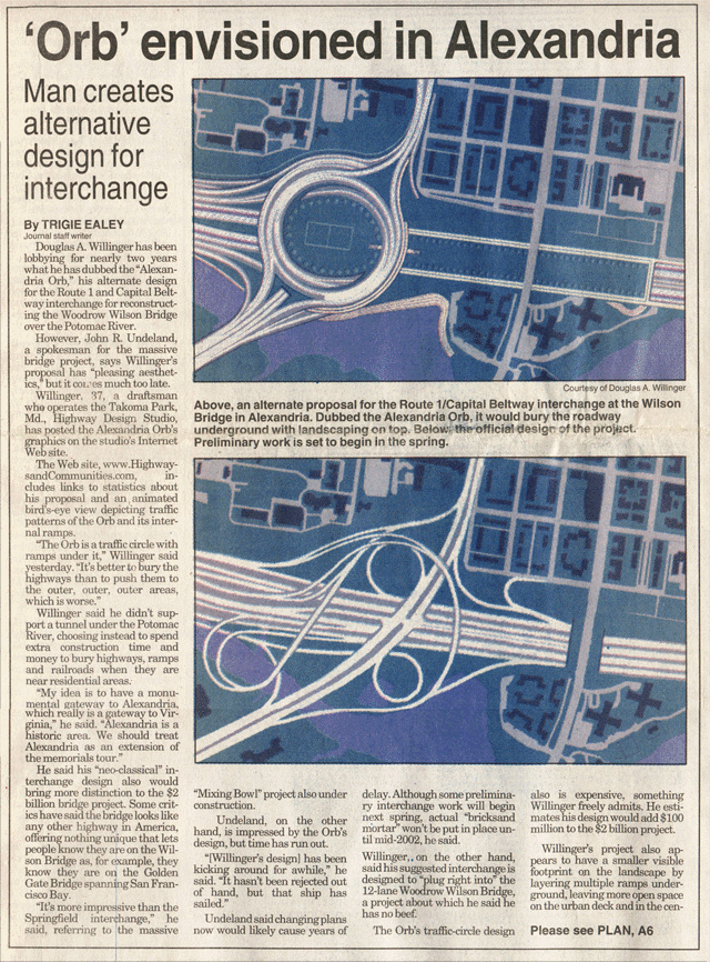
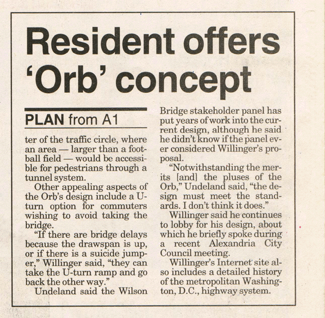
Alexandria Orb Page One News December 18, 2000


Six days after the Alexandria City council voted to trade away most of the proposed Washington Street Urban Deck, the Alexandria Orb with its far more generous lengthier urban deck made page one of The Alexandria Journal, and The Fairfax Journal on December 18, 2000.

Note the ironic juxtaposition with the article about “City negotiating with Feds for open space: Jones Point redesign prompts new talks”, (let alone “Schools turn to big brother: Surveillance Discussed”).

Strange how such negotiations never seemed to include any request to even study the Alexandria Orb design or concept, let alone restoring some of the lost proposed deck as proposed from 1994 to 2000.

This includes the subsequent time, post September 11, 2001, when anti-terrorist incidence planning eliminated the vehicular parking lots beneath the new spans, relocating them elsewhere in Jones Point Park. It seemed to me a logical time for a renewed request to adopt the Alexandria Orb, in late 2001-early 2002, just as construction preparations were underway for the thing that is now – as spring 2007, is almost complete.


What Happened At Alexandria City Hall

The Alexandria, Virginia Government Lies

The Route 1 Interchange/Washington Street Urban Deck Stakeholders Participation Panel overwhelmingly rejected the shorter deck, August 26, 2000.

Nonetheless, the Alexandria City government sold out with a proposal to “trade in” most of the funds for the urban deck for amenities elsewhere in Alexandria. This would trade away the environmental mitigation most needed by those nearest to the highway, to neighborhoods further away from the highway, with the policies contained within City Manager Phillip Sunderland’s October 20, 2000:

"RECEIPT OF REPORT ON THE WOODROW WILSON BRIDGE PROJECT PLANS FOR JONES POINT PARK AND THE URBAN DECK AND SETTING THE REPORT FOR PUBLIC HEARING ON SATURDAY, NOVEMBER 18 AND COUNCIL CONSIDERATION ON TUESDAY, DECEMBER 12."

It would state:

"There is general support for the concept of a shortened deck."

And at page 10:

"The Design Review Working Group supports whatever decision the City makes on the deck. The Urban Deck Stakeholder Panel, as a group, has not been presented with the plans for the smaller deck because they have not yet met."

Wrong. The Urban Deck Stakeholder panel met on August 26, 2000, and said no.

Nonetheless, at the subsequent events, the Alexandria City Council pretended otherwise.

With no public debate about the deck reduction, on December 12, 2000, they approved it unanimously.

That’s some government.