Tuesday, February 13, 2007

Comments February 24, 2000 Under-Appeciated Matters of Sound

Comments; February 24, 2000
Under-appreciated Matters of Sound
SOME POINTS TO STRESS REGARDING THE DEFICIENCIES OF THE FORMAL PLANNING PROCESS FOR THE WOODROW WILSON BRIDGE REPLACEMENT PROJECT:

ENVIRONMENTAL ISSUES ARE NOT BEING ADEQUATELY ADDRESSED FOR THE LOCAL AREA, whether as a 10 or 12 lane facility; both would place major highway approach only 10-30 feet away from what would be the nearest Hunting Apartment Tower, whether the now northernmost tower, or the middle tower, made into the northern tower by the first tower's demolition.

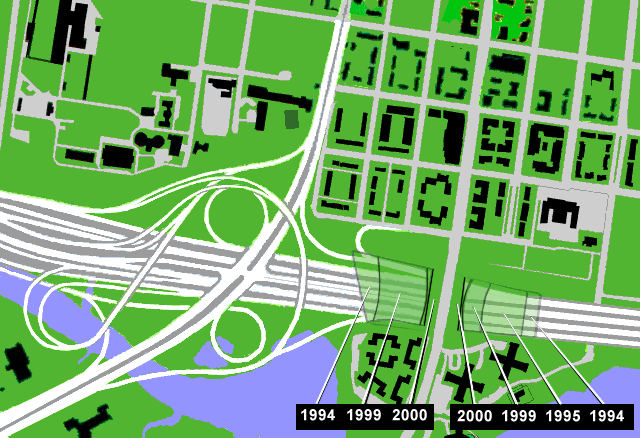
Design decisions concerning the Washington Street Urban Deck are compromising its utility for much needed mitigation in southern Alexandria. Recent decision to maintain Church Street exit ramp in its current location has been followed by apparent decision to delete the canted western edge (from the northwest corner of the Hunting Terrace parking lot to Alfred Street) with a straight edge (or curved variant) with a loss of up to 44,000 square feet of potential landscaped green open space (200' length X 440' width of deck divided by 2)! See DRAFT SEIS Figure 4-13 "Carbon Monoxide Modeling Locations Urban Deck- West Exit Portal" (canted edge can be discerned from the disappearance of the black lines that indicate the eastern portion of the proposed Route 1 interchange).

This is not the first decision to reduce the benefits of the proposed Washington Street Urban Deck: note the inexplicable failure to extend the deck fully to the east of Hunting Towers; initially the deck was to extend just past Hunting Towers, yet a decision made around 1994 was made to truncate the deck just east of the northern *wing* of the nearest Hunting Tower, thus leaving that tower's eastern wing in close proximity to the noise and pollution of the 10-12 lane I-495 approach, some 80 feet away: a deletion of at least 30,000 square feet of potential landscaped green open space (100' length X 300' width). My initial questions to the officials at the Woodrow Wilson Bridge Design and Study Center were met with answers about the fact that this portion of the deck would have a slope of 5%-6%, and result in a higher visual profile.

These following questions to the officials on this matter would be met with silence.

a) that so truncating the deck would instead place a highway with a %5-6% slope in close proximity to Hunting Towers (as if that were locally preferable to a landscaped park!),

b) that the issues of vertical height makes little sense when this portion of the project is likely to receive vertical sound walls (see DRAFT SEIS Figure 4-15 " Current Design Alternative 4A Potential Noise Barrier Locations)

c) that this is a highly questionable decision considering the obvious need for sound barriers that address noise that travels upwards. See:

http://www.djc.com/special/design95/10002599.htm

They add that [standard vertical sound wall] barriers are designed for ground floors only; upper floors receive little or no benefit. "It all depends on location," says Martin Palmer, Assistant Environmental Program Manager for the Washington Dept. of Transportation. "The reduction is heard only by the residents closest to the wall." He adds that benefits are variable, at best.

Highway encasement of the deck could provide effective noise mitigation. Indeed, this very concept of the covering of freeways with decks, caps or lids as they are known in the western U.S. is environmentally popular. Please see:

http://www.asla.org/centennial/OR_I405C.htm
http://www.oregonlive.com/todaysnews/9807/st070309.html
http://www.seattlep-i.com/neighbors/judkins/bg1.html
http://arts.endow.gov/pub/Design95/pda/inter.htm
http://www.dkassociates.com/plan/3.html

d) that such a sloped deck is a key design feature of a proposed covered highway project in New York along Manhattan's upper west side between 72nd and 57th Streets, see:

http://www.pb4d.com/projects/highways/miller/maerials/maerials.htm
http://www.pb4d.com/projects/highways/miller/maerials/13f-opa.jpg

by Parsons Brinckerhoff, the firm that is currently coordinating the Woodrow Wilson Bridge Replacement Project!

e) That decision half a decade ago to deny the benefits of this potential highway encasement to the eastern *wing* of what would be the northernmost Hunting Tower, is being apparently supplemented with a NEW decision for an additional 200 foot deletion of decking at the eastern end, ending the deck fully west of the northernmost surviving Hunting Tower, and exposing the entire northern side of that tower the benefits of the potential landscaped green park space, placing that building 10-30 feet away from 10-12 lanes of Beltway traffic. See:

DRAFT SEIS Figures 2-5 "Washington Street Urban Deck Conceptual Mitigation Plan" and "A-1 "Preliminary Interchange Design Key Plan".

This deletion of 60,000 square feet of landscaped open green park space (200' length X 300' width) would effectively reduce the size of the Washington Street Urban Deck, east of Washington Street, by approximately 50%. It would in effect take away about half the area of the playing field illustrated in the upper left quadrant of the cover illustration of the official publication, "The Woodrow Wilson Bridge Improvement Study: A Summary" Summer, 1997; under the revised deck plans, about half of the area of the recreation field would be deleted, and with the remaining area made into a small park (DRAFT SEIS Figure 2-5.) As this document shows the earlier configuration (with the canted western edge deleted in the area of the Church Street exit ramp) with regard to Figures 4-13 "Carbon Monoxide Modeling Locations Urban Deck- West Exit Portal" and 4-14 "Carbon Monoxide Modeling Locations Urban Deck- East Exit Portal", it is not entirely clear which deck configuration is the final design.

It would appear that, in addition to the demolition of the northernmost Hunting Tower, that the planners might be writing off the currently middle Hunting Tower, at least as a place of residence.

NO alternative designs have been considered for the Route 1 interchange, particularly the approach of the citizen's alternative Alexandria Orb proposal.

The official design with local and express roadways, though offering the potential space for the concurrent or future rail transit, is flawed in two regards:

a) Assigning BOTH tasks of serving as an HOV lane and as a future transit lane places these two modes in direct conflict, possibly threatening the eventual addition of Metro Rail by motorists groups that would not want to relinquish the HOV lane. Rail deserves a physically separate right of way that by its very design, would not be susceptible by possible future demands for maintaining or functionally expanding highway capacity, such as a simple 12 general purpose lane bridge designation. Would the planners of the Woodrow Wilson Bridge replacement project argue that inside the Beltway I-66 should have been constructed WITHOUT either Metro or a dedicated separate railway right of way- leaving the promise of future rail transit vulnerable to future politics.

b) The construction of ramps that conflict with the future addition of rail, whether in the median, or in the shoulder space between the local and express lanes. As officially configured, the Route 1 interchange in alternative 4A provides access to and from the east for the I-495 express roadway, with left hand ramps, which would need to be demolished for future rail transit conversion of the HOV lane (and which the official design does not provide an alternative location for ramps between the I-495 express lanes to and from the east and Route 1). Conversely, the official design provides a right hand on-ramp to the I-495 eastbound roadway, which would conflict with the addition of Metro rail transit via conversion of the shoulder space between the local and express lanes.

A FURTHER POINT: JUST HOW FORTHCOMING HAVE THE AUTHORITIES BEEN AT SHOWING THE PUBLIC RENDERINGS OF THE FINISHED PRODUCT?

Has the Woodrow Wilson Bridge replacement project been as forthcoming with renderings of the proposed project to the degree of other important highway infrastructure projects in the United States? For instance, projects such as New York's canceled Westway project, as well of Boston's current Central Artery Tunnel Project, were featured in models that were placed upon public display; indeed, the public design process for this project's northern portion, the Charles River Bridge, led to a design process where the numerous proposals, including the initially chosen "Scheme Z", where displayed three dimensionally with models. (See the book "Rescuing Prometheus" by Thomas P. Hughes at www.barnesandnoble.com). Yet, asides from one or two small scale cardboard models with little detail that have been seen in the past at the Woodrow Wilson Bridge Design and Study Center, the only model otherwise seen there is one of the existing bridge.

While numerous renderings have been so presented of the replacement bridge, none have been provided that show the area of its abuutement/approach in the tightly settled area between St.Mary's Cemetery and Hunting Towers, nor that of the Route I interchange (which is illustrated only in a direct overhead view).

Douglas A. Willinger
Takoma Park Highway Design Studio

How highway design might have been shaped in Alexandria

I wrote this for the Alexandria Orb web site in 2000

The Alexandria Orb proposal has precedent in the tale of the Scheme Z portion of Boston's current Central Artery Tunnel Project: the substitution of a newer design for the approach ramps to the new Charles River I-93 and Starrow Drive Bridges, replacing the aesthetically unpopular scheme z (so named for being as the 26th design proposal formally considered, complete with 3D models of each of these 26 design proposals that were placed on public display during the selection process.

Adapting the Alexandria Orb proposal would afford little if any delay, if we take advantage of time between start of bridge construction and the start of construction upon the approaches. Unlike the Scheme Z saga, where there was no citizen's alternative design at its onset, the Orb design already exists and is ready for being refined and adapted to the official project plans.

The Alexandria Orb would likely add a minimum of $100 million to the $609 million FHWA Route 1 interchange design for this $2-2.5 billion project, respectively a cost increase of about 15% or 5% taken for the interchange or the whole project.

Approximately $50 million could be pared from the Alexandria Orb proposal if this design were constructed without the full deck within the Orb roadways (which could still be added at a latter date).

The added costs would be a fraction of those for a full tunnel crossing beneath the river.
Of course these figures were for adapting the Alexandria Orb in 2001-2001, and not 2007 -?

The Alexandria Orb Brochures

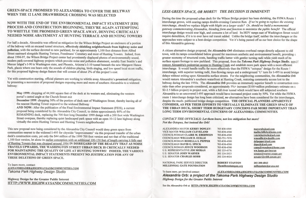
To inform the people of Old Town Alexandria, particularly those living southwards of its City Hall, I created an Alexandria Orb pamphlet showing the curious reduction of the urban deck that appeared later in 2000.

The brochure shows not only the interchanges but also what was happening to the proposed Washington Street Urban Deck, both visually and via additional text on the reverse.

This color brochure lacks the top line that appeared on the non-color version that I distributed more widely through the southern portion of Old Town, Alexandria: Springfield in Alexandria”.

I distributed several hundred of the color brochures in the several blocks immediately adjacent to I-495. And I distributed several thousand of the non-color version of the brochure in the entire area to the northern edge of the neighborhoods to just south of Alexandria City Hall.

I also distributed notices about the public meetings held at Alexandria City Hall.

I also had a button made up showing the Alexandria Orb and the Alexandria Octopus.

The Orchastrated Meeting

Having followed the Wilson Bridge project since mid 1994 and going to its numerous public meetings, including that SPP meeting of August 26, 2000, I was not happy to hear within the following month, of some other meeting, apparently invitation only, favoring the contrary position.

I only heard about this meeting afterwards. Interesting how I never saw this meeting coming when I was on the look out for public meetings. After all that's how I found out in advance about the SPP's August 24, 2000 meeting.

Sentiments that came out of this included fears of Alexandria being stuck with the bill to pay for the electricity to run the urban deck’s ventilation systems, and of having to hear the sounds of people at recreation, rather then 14-17 lanes of freeway and ramps!

So-Called "Environmentalists"

I was not happy to see that the great mass of likely self-identified environmentalist people who attended the first portion of this August 26, 2000 meeting (about the proposal for a new bike path through Jones Point Park), all leave immediately like a group of drones after that segment was concluded, and hence miss out entirely upon the second segment which dealt with the urban deck.

Apparently, land use, waterfront access and noise abatement are not “environmentalist” concerns?


The SPP's August 26, 2000 Rejection of the Deck Chopping

On August 26, 2000, a joint meeting was held for the Stakeholders Participants Panel on Jones Point Park and for the Stakeholders Participants Panel on the Route 1 interchange and the Urban Deck.

The latter was there to consider this new proposal, that had two versions: the slightly curved Concept "A" "Greetings"; and the straight-edged Concept "B" "Streetscape."

SPP members and the attending public were given the opportunity to speak about the proposal. At the end of this meeting, the project officials asked the SPP for their formal recommendation upon the new deck proposals; I was one among the public speakers who spoke out against shortening the deck. Responding that they had heard too many bad things about the new proposals, the SPP would that day publicly recommend AGAINST the shortening the deck. Of the 7 or so SPP members present, only one voiced the opposite position. I was there to see and hear this.

I was happy to have this opportunity to speak before this SPP, and to see it vote favorably.

EIS Comments: Alexandria Orb Un-Considered By Authorities


518

2/25/00 Yvonne Weight:

It would appear that no consideration was given to the “Alexandria Orb”

configuration of Route 1, although such a design creates the possibility

that significantly more space could be covered and utilized as park or

recreation land; indeed, DOT should be required to show in each and

every EIS how much concrete it could actually cover.


4/14/00 FHWA:

During the planning process, twenty-five configurations were studied for

the U.S. 1 interchange. In addition, opportunities were provided for

individuals to present their proposals during the Coordination

Committee Meetings, work group sessions and other public meetings

and hearings. Based upon the consideration of the Coordination

Committee, not all proposals were determined to be further studied. The

requirements for comparative elements to be included in the EIS are

based on items that encompass community, environmental, traffic, cost

elements and differentiating factors.

5/30/00 Douglas Willinger TPHDS:

a) None of these 25 Route 1 interchange configurations included any

designed to cover any of the ramps; this stands in contrast to the use of

"fly under" ramps used successfully in the Mercer Island I-90 project and

elsewhere;

b) Opportunities were of course provided during the public comment

periods allowed at the various Wilson Crossing events; nonetheless, this

does not mean that a proposal's presentation during any of these periods

would receive formal consideration by the Coordination Committee; from

the documentation that I am aware of, this Committee apparently gave

NO formal consideration to the Alexandria Orb proposal, despite the

comparative elements so involved that are enumerated above.


Page 78

Woodrow Wilson Bridge Project

Federal Highway Administration Record of Decision

Attachment 3 - Comments and Responses

78

523

(Consideration of the Orb proposal; extension of covered portion of I-495

to the west of the official preliminary plan.)

4/14/00 FHWA:

This aspect of the project, extending the deck to the west

would be considered outside the scope of the project. The access to

Hunting Creek would be unchanged from the access today.

5/30/00 Douglas Willinger TPHDS:

Untrue on both counts. The Orb proposal falls entirely

within the geographic area of the existing proposed project, in fact the

project area includes the interchange to the west of the Route 1

interchange, to say nothing of to the east to include the river crossing and

the two interchanges to its east. By extending the covered area of I-495

to the west as part of the Alexandria Orb proposal, it would entirely

bridge the gap between the Yates Garden neighborhood and the

northern shore of Hunting Creek, with a terrace to so provide this access,

possibly in the manner that access is provided to the Potomac River just

west of the Lincoln Memorial.

525

2/25/00 Douglas Willinger TPHDS:

The Alexandria Orb/Promenade proposal is a replacement design for that

portion of the project upon land in Alexandria, specifically the area of the abutment, the urban deck and its

western extension . Indeed, the Alexandria Orb/Promenade is a

consolidation of an extended, landscaped highway deck, with a partially

underground spherical replacement design for the Route 1 interchange.

It does not alter the basic design configuration of the bridge itself. As so

conceived and drawn (in AUTOCAD 14), this proposal is fully compatible

with a 12 lane configuration with separate local and express roadways,

with a ramp configuration without conflict with the addition of Metro rail

via left-hand local roadway and right-hand express roadway shoulders,

as well as being adaptable to a broad range of bridge crossing options,

including partial and full tunnel river crossings, as well as those with

differing numbers of lanes.


Page 79

Woodrow Wilson Bridge Project

Federal Highway Administration Record of Decision

Attachment 3 - Comments and Responses

79

4/14/00 FHWA:

The US 1 interchange was studied extensively during the

planning process, documented in the 1997 FEIS and is not subject to

major reconsideration. The Stakeholder Participation Panel assigned to

refine the US 1 interchange was satisfied with a majority of the

movements, although still had some issues.

5/30/00 Douglas Willinger TPHDS:

This design is not necessarily set in cement, as attested

by the example of the Boston Central Artery/Tunnel's adaptation and

eventual replacement of the "Scheme Z" design configuration for the

approach ramps to the replacement I-93 Charles River Bridge. Popular

disenchantment with the officially chosen "Scheme Z" alternative would

led to its outright abandonment, and its replacement with a new design to

plug into the rest of the Central Artery/Tunnel Project. Official recognition

of this sentiment led to a renewed design effort for this portion of the

project, minimizing any possible delays to the rest of the project. By

adapting and incorporating the Alexandria Orb/Promenade proposal within the project

design, we can take advantage of the time that we have (especially given

the legal delays that are likely to occur over the next 9 months) the

project could essentially proceed without further delays. In any case,

construction will begin upon the bridge (or tunnel, in the event of such a

change in plans), before it begins upon the approaches, thus further

allowing time to adopt the Alexandria Orb proposal, which is confined to

the interchange, the approach and the roadways in the immediate area of

Royal Street.