Monday, August 13, 2007

Washington, D.C. Big Dig

http://www.shaunkenney.com/2006/03/tc-is-answer-dc-big-dig.htm

Jim Riley has one of the most thought-provoking posts I've read in a long time when it comes to transportation, namely whether or not the time has come for a D.C. Big Dig:
If a D.C. Big Dig (or anything like it) is ever to be done, this is something that will take an Act of Congress and may have to be shoved down the District’s throat. Am I comfortable with that? Not really, but it is a Federal city, so there is some logic to congressional involvement in spearheading such a project. Congress should also retain oversight and the ability to appoint top officials overseeing it. Perhaps they could tap Massachusetts Turnpike Authority Chairman Matt Amorello, a former State Senator and Republican candidate for Congress from the Worcester, MA area, to head it up. Amorello took over the Big Dig in Boston and turned the troubled project around.

It’s time to stop nibbling around the edges and do something bold to attack our region’s traffic problem. Doing nothing is not an option. Too many politicians have taken that road for too long. This goes to the very heart of the traffic beast in our region. Until someone slays that dragon, all the other work that we do will only continue to forestall the inevitable return of gridlock resulting from commuters trying to get into D.C.

Tuesday, July 10, 2007

Volvo’s Subliminal Message for Takoma Park


Douglas A. Willinger
Takoma Park Highway Design Studio

Published in the July 1997 Takoma Voice

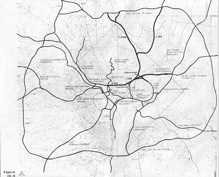
Beyond a possible Federal highway conspiracy with the telephone company to subliminally promote an interstate highway through Takoma Park via the telephone interchange “270 [See: True Fiction,Takoma Voice, April 1997”, what about that being suggested by the Swedish auto-maker Volvo with its new sedan, the “S70”- a likely play upon “70S”, the former name of what we would call the I-270 extension inside the Beltway, known as the “North Central Freeway” that was to run through Takoma Park, along a number of alignments proposed during the 1960s, including Sligo Creek [1963] and along Philadelphia Avenue [1964- right through the site of Takoma Towers], rejected for their destructiveness to houses and park lands.

Subliminally reminding us that this is the ultimate “inside the beltway” car for this inside the beltway highway, whether S70, 70S, 270, or perhaps 270 S, connecting ultimately with the 3rd Street Tunnel downtown, the Volvo S 70 could make for one fast ride downtown. You know it is an omen if you see any of these Volvo sedans at the Takoma Metro parking lot, or in desolate used – car storage lots on the other sides of the tracks – the logical site for this as of yet un-built expressway, employing existing rail-side industrial properties – rather than clear-cutting through neighborhoods. They bespeak of a day when Volvo sedans, filled with shoppers and car-poolers – and heavy traffic in general – traveling into and out of the District have an alternative to driving upon largely residential surface streets.

Furthermore, the advertising slogan for the S 70 suggests a future for an I-270 extension inside the Beltway, ultimately connecting with an upgraded 3rd Street Tunnel: "S70 Unlike any Volvo before it!"

That is, a future for such an I-270 extension UNLIKE those plans of the 1950s and 60s that raised so much ire, such as plans for expressways through Rock Creek Park, then along Wisconsin Avenue and Potomac Palisades, before being kicked over through Takoma Park by 1964 (needlessly cutting a new swath through long-established neighborhoods of Victorian homes and relatively old growth trees along Philadelphia Avenue, rather than hugging the existing B&O rail corridor.

By 1967, the plans for the “North Central Freeway” were reshaped with the proposed highway hugging each side of the rail corridor (with Metro). In response to citizen sentiment, a 1971 highway design consultant report [Deleuw, Cather and Harry Weese Associates, released that November] proposed placing this stretch of I-70S beneath decking between Aspen Street and Piney Branch Road. Foolishly, this plan placed both directions of I-70S along the rail corridor’s east side, thus committing the atrocity of removing the landmark Big Brown on the corner of Eastern and Piney Branch (roughly 85 feet from the tracks) [otherwise known as the Cady-Lee Mansion, at 7064 Eastern Avenue, built around 1884 and designed by the same architect who designed the official residence of the Vice President), along with the Victorian houses northwards along the Takoma Avenue facing the tracks. (All the while preserving the then mainly empty properties northwards along the railroad’s west side for building new apartments as well s “townhouses” along Blair Road. Unlike any 70S before it, any acceptable I-270S is going to have to place the proper respect—this is a historic District and a City. Give us an I-270S tunnel. Use the existing railroad corridor, judiciously widened to avoid classics including Big Brown. Place the existing railroad underground too! Maximize the local benefit by giving Montgomery College access to Blair Park, and the creation of a new Takoma Town Square (complete with a replica of the original Takoma station that was destroyed by fire in 1967) to replace that existing WALL of an elevated railway.

Modern cities around the world are working to complete their urban expressway networks, replacing the destructive planning of the past for a new generation of primarily underground roads. With tunnel portals designed by landscape artists.

Check out what Boston is doing – take a look at the new Charlestown Town Square/Highway Tunnel. How about a new grand mall stretching from Union Station to Silver Spring.

Watch out for any S 70 Volvo sedans spinning their wheels, or parked in the portion of the Metro parking lots closer to the railroad, let alone the used-car lots on the other side of the tracks!


B&O railroad corridor looking south-east from Takoma WMATA Station


B&O railroad corridor looking west from Takoma WMATA Station

I-270 Takoma Station Tunnel

Build a Washington, D.C. Big Dig

Tuesday, May 22, 2007

1971 North Central Freeway Routing Mystery

Accordingly, people in Takoma Park opposed the North Central Freeway, even with the B&O railroad route as proposed in November 1962, because it would displace a row of houses.

Indeed, this was so with both the 1966 and 1971 B&O route North Central Freeway proposals. Although the 1966 plan included a set of 3 lane tunnels alongside the railroad further to the north at the vicinity of Montgomery Community College and Blair Park, it transitions to an open depressed and then elevated along the elevated portion of the railroad where the topography falls back in the Takoma Station area, with 3 lanes on each side of the railroad. This avoids the Cady Lee Mansion, but it relocates Takoma Avenue displacing the adjoining Victorian houses. The 1971 plan replaces this with a 6 lane tunnel on the railroad's east side; this displaces the Cady Lee Mansion, with the open trench portion to the north relocating Takoma Avenue and displacing those houses.

A design with 3 or even 4 lanes on each side of the railroad as cut and cover tunnels would have preserved all of these houses, with Takoma Avenue reconstructed in its existing location atop the northbound cut and cover tunnel.

Why then was not such a plan ever drawn up?

1966 North Central Freeway Routing Mystery

Why does the 1966 plan adopt an alignment with greater parkland impacts at Fort Totten then the 1964 plan?

1964 plan which follows the railroad at Fort Totten

1966 plan which veers to the west at Fort Totten

Why add an objection that was lacking in the earlier plan?

Wednesday, May 16, 2007

B&O "Y" Route Convergence Critique

1966 B&O Route Low Level I-70S-I-95 "Y" route

It was under capacity: committing the cardinal sin regarding the number of lanes, with a lesser number fed by a greater number.

A 6 lane upper left I-70S, and an 8 lane upper right I-95, should converge into 14 lanes, not the mere 12 of the 1966 design (with a questionable 1 lane drop for I-95 at its ramp connections towards North Capitol Street), that would quickly funnel into 10.

I-70S-I-95 convergence
1966 B&O Route Low Level

This set of design defects was shared by the 1964 plan, which also fed more lanes into fewer. The 1964 plan had 6 lanes apiece from the 8 lane main roadways of I-70S and I-95 converge into 12 lanes quickly narrowing to only 10 (plus the 2 lane reversible median roadway that had not been planned with connections to the I-95 Northeast Freeway), with both I-95 and I-70S having a 1 lane drop and pickup, the former for the North Capital connections, the latter with “round the corner” connections between both highways to exchange their southbound to northbound traffic, e.g. southbound I-95 to northbound I-70S and southbound I-70S to northbound I-95: a connection that.

Provided that traffic patterns would allow the lane drops, the combined 6 or 8 +2 I-70S and 6 or 8 I-95, would ideally require the sum of these numbers: 14 to 18 lanes.

As per the 1964 design with its 2 lane median roadway for I-70S (but not I-95), this would translate to a 6/2/6 or 8/2/8 cross section, or perhaps a duel barrel design, with a 4/4/2/4/4 configuration.

To accommodate this number of lanes, the existing 6-8 lane Center Leg would require the addition of an 8 lane East Leg, plus parallel cut and cover tunnels beneath 2nd and 3rd Streets NW/SW along the Center Leg, connected to a new preferably underground SW/SE Freeway with additional capacity for the SW Freeway, and to a new South Capitol Street corridor tunnel.


I-70S-I-95 convergence
1964 Route #11 (Railroad East-Sligo)

Combined with the respective inside the Beltway I-70S and I-95 interchanges with Maryland Route 410 would provide a useful bypass of normally 4 lane 410’s 2 lane bottleneck through Takoma Park. However the latter plans delete this feature.

It would have been interesting to see consideration of greater capacity, with a design capable of as much as 24 lanes, and with separate express carriageways, encased in a multi-cell cut and cover tunnel. Curiously, such a design was not drawn up, despite the utility of the cut and cover segments, particularly if such would bury and stack the express carriageways.

Such a cut and cover tunnel would accomplish and reconcile greater human activity within the existing footprint.

It would cost very little money compared to the various war budgets, and would serve the idea of greater evacuation route capacity that some within the government gave lip service to after 911.

Friday, May 11, 2007

1966 B and O Route Design Persuit

This railroad “Y” Route concept for the Washington, D.C. North Central Freeway, recommended by the November 1, 1962 “Recommendations for Transportation in the National Capital Region: A Report to the President for transmittal to Congress” by the National Capital Transportation Agency, under U.S. President John F. Kennedy, only become the object of the supplementary (the 2nd) North Central Freeway engineering feasibility in late 1966. That 1966 Supplementary Study explored four variations of this B/O “Y” route concept:

· (1) High-Level option: Elevated freeway over or immediately adjacent to existing Railroad, permitting lower lying commercial and industrial buildings to remain in place under the facility.

· (2) Low-Level option: Freeway generally at or below the Railway, located immediately adjacent to the Railroad. .

· (3) Freeway below the Railroad grade, with the Railroad and transit facilities supported on a structure over the Freeway.

· (4) Freeway approximating the existing Railroad alignment and grade, with the Railroad and transit constructed beneath the Project.

Options 1 and 2 would preserve the existing railroad, while options 3 and 4 would remove and replace it.

It recommended option #2: a “low level” route alongside the existing railroad.

It deleted the reversible median roadway that was a feature of the 1964 North Central Freeway plan (but not its connecting I-95 Northeast Freeway), and that for Virginia’s I-95 (I-395) Shirley Highway.

It was further recommended that the depressed portion in Brookland near Catholic University of America be covered (with what’s been called a lid, cap, or deck), effectively making that segment a cut and cover tunnel, with the space atop devoted to new housing and park and recreation space. It includes an illustration showing such a highway cover extending from the north end of the main Catholic University of America campus, southwards of the Brookland/CUA train station.

Such a cut and cover tunnel would additionally shield the area from noise and pollution.