
Superior Environmentally A Shield for local neighborhoods against traffic noise and emissions along southern waterfront and area of incline/descent: Extended covering of highway blocks noise and emissions in key area where grade changes -- the rise to the bridge and the descend from the bridge - forces vehicle to compensate with greater engine acceleration or braking make this particularly acute. Superior Sound Abatement: Highway cover effectively suppresses noise, particularly that which travels up. Reducing Air Pollution: Covering of highway accompanied by a ventilation system equipped with filtration (official plan had promised a ventilation system that merely dilutes before it was quietly deleted near the end of the EIS process) |
| Superior Aesthetics Smaller footprint than official design: No fly-over ramps that cross Cameron Run; no fly-over ramps adjacent to Old Town. All ramps below the 38 foot above sea level Surface Orb. More efficient use of land: primarily underground spherical roadway consolidation, with surface reclaimed for park use! This creates several hundred thousand square feet of new parkland, South Alexandria Park, Hunting Terrace Promenade Park, Freedman's Cemetery Park and Royal Landing Park, as opposed to the ever-more-truncated official proposed design for the Washington Street Urban Deck. Greater long term revenue for Alexandria: Enhanced property values for Hunting Terrace-Hunting Towers; new potential for Route 1 redevelopment west and south of Cameron Run. |
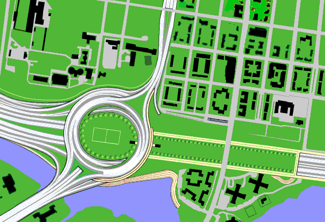
| Superior Operationability Gentler ramp radii then official design: Ramp movements handled by separate ramps at varying levels, concentrically along, within or beneath approximately 800 foot diameter traffic rotary for Route 1 local and Route 1 to Beltway Traffic. 800 foot approximately diameter ramps- larger then the ramps of the design on display at the Woodrow Wilson Bridge Study and Design Center. I-495 eastbound to westbound "U" Turn Ramp WITHOUT exiting onto Alexandria surface streets: Allows I-495 Capital Beltway traffic bound for bridge to reverse direction via underpass beneath I-495 in case of drawbridge delays. Official design requires such traffic to divert to Alexandria surface streets, beyond interchange, as official design does not allow direct access within interchange for traffic from I-495 eastbound to I-495 westbound ramp. Free-flowing I-495 westbound express to Route 1 south traffic: without a stop sign or a light, unlike the official FHWA design. Full Metro Compatibility on Bridge without conflict with HOV lanes or ramps: No right hand express lane ramps, so as leaving no physical barriers to concurrent or future addition of Metro Rail via conversion of right hand express lane and left hand local lane shoulder space. Full Access to Eisenhower Valley, with access to and from the local and express roadways Intuitive design: left is left; right is right: for northbound drivers, left is west, right is east; for southbound drivers, left is east, right is west; for eastbound drivers, left is north, right is south; for westbound drivers, left is south, right is north. Route 1 Tunnel: with portals at southern edge of interchange, with northern portal at Franklin Street for Route 1 traffic, plus intercepting I-495 express westbound and eastbound traffic, sending it north of Franklin Street. |
PURPLE LINE FRIENDLY: This design features access to and from both the local and express roadways, with right and left hand ramps respectively, so as to allow shoulder space conversion (the left hand local roadway and right hand express roadway shoulders) for concurrent or future Metro rail, without taking away a vehicular lane: in other words it would allow HOV with rail. This interchange features a tighter design, using less land then the proposed design (no ramps that twice cross Cameron Run), yet with ramps with a greater turning radii, roughly following the 800 foot surface orb diameter.
The design drawing shown on this page is for a 12 lane bridge with separate local and express roadways with shoulders. The basic design, as it primarily addresses the area from Royal Street to the Route 1 interchange, is adaptable to alternative river crossing proposals, including 10 lane, split bridge-tunnel and full tunnel options, including a 10 lane option with an additional 2 lanes in the median for Metro which would drop beneath the I-495 roadways, which would then converge to "thread the needle" between Hunting Towers in Jones Point Park.
The Alexandria Orb answers the issue of tunneling via burying a commensurately far shorter section of I-495 then building a river crossing tunnel, at a location where such a treatment would provide the greatest mitigation benefit. This proposal would "bury" 4/10th of a mile of the approach, with its eastern end at the location of the edge of the bridge's abutment just west of Royal Street, and with its western end at that end of the spherical
The Alexandria Orb is the only alternative design concept for the Woodrow Wilson Bridge Route 1 interchange; its extra expense would be offset by its multi-purpose mitigation, its creation of a new green space in proximity in southern Alexandria, both at the most historically rich and environmentally sensitive area, and as a Historic District and State of Virginia gateway.
Located in the broad axis of Delaware Avenue/Union Station, roughly midway to the Mt. Vernon traffic circle, Alexandria Orb Promenade may be considered as an extension of the architectural grace of the monumental core.

| ROUTE 1 SOUTHBOUND: to I-495 west: via 800 plus foot open ramp, maximum grade 3.5%; minimal curvature 473 feet radii. to I-495 west express via fly-overs, 1/8 mile west. to I-495 east local: via arced, recessed ramp to local tunnel way; maximum grade 3%, minimum curvature 420 feet radii. to I-495 east express: via arced, recessed ramp to express tunnel way ramp; minimum curvature, 420 feet radii. |
| I-495 WEST LOCAL: to Church Street: underground ramp to Church Street portal, east of Columbus Street to Route 1 north: underground ramp and merge to Route 1 tunnel portal at Franklin Street and fully emerging to Surface Route 1 at Gibon Street to Route 1 south: underground ramp, emerging west of the Route 1 traffic circle, along outer western edge of the sphere. Minimum curvature, 456 feet radii. |
| 1-495 WEST EXPRESS: to Route 1 north: underground ramp to Route 1 underpass-tunnel (w/o access to Franklin Street) to Route 1 south: underground ramp, crossing beneath I-495, ascending to emerge with the above-mentioned Route 1 south to I-495 west ramp, along outer western edge of sphere. Minimum curvature 420 feet radii. |
| I-495 EAST: from express lanes via fly-overs, 1/8 mile west to Route 1 north to I-495 west (high capacity continuous flow U-turn for bridge detour) |
| ROUTE 1 NORTH: to I-495 east local, maximum grade 3%; minimum curvature 309 radii to I-495 east express |
| COVERED I-495: 2,900 feet long encasement beneath Orb and Promenade, past Hunting Towers to abatement just west of Royal Street. |
| ROUTE 1 EXPRESS TUNNEL 1975 foot long 4 lane tunnel from south of the Orb to Franklin Street |
| SURFACE ORB: for Route 1 local, and Route 1 to I-495 Beltway traffic |
| METRO RAIL PURPLE LINE: via left hand local/right hand express shoulder conversion, with out the right hand express ramp conflict of official Route 1 interchange design |
Click on image to see it as animation
| Acres of spaghetti and freeway maze no-man's land- that is, no man or women's outside their automobiles! Or acres of a new spherical park, as a signature southern Alexandria Gateway |
|
Increased property values all around Route 1 Economic Renaissance Cameron Run Restoration: Cameron Run, transformed, new recreational uses along Run, new economic development in re-use of existing paved over properties, unimpeded by the official plan's giant Route 1 Southbound to I-495 Eastbound fly-over ramps that twice cross Cameron Run. This is all from the Alexandria Orb web site, started in 2000 and redesigned in 2002.. |


No comments:
Post a Comment