Friday, January 06, 2012

Grand Arc 95-270


Time to rectify the social injustice of pushing the traffic burden disproportionately through SE, and that previously of the railway burden, to finally deliver Washington D.C.'s missing freeway linkage AND a new Northern Mall

JFK's Administration first proposed it as part of a "Y" route, along with the Committee of 100 on the Federal City - a tightly routed I-95 and I-70S along the B&O Metropolitan Branch RR -- Washington, D.C.'s sole above ground grade separated transportation corridor.

It was botched afterwards, politically sabotaged by the initial North Central Freeway engineering study which excluded it while considering instead an upwards of 37 routes all over the map, with a recommended route partially following the RR but with serious deviations in Brookland and especially Takoma Park. Though decently re-scribed in 1966, the B&O NCF was nonetheless demonified politically as a "white mans road through black mans homes" -- with infinitely greater protest hype upon the 34 houses in Brookland closet to the RR than the 600+ for the final North Leg East segment to link with the existing Center Leg (3rd Street Tunnel) -- never-mind it was relatively uncontroversial while the U.S. President who proposed it was still alive- JFK.

Politics of the past asides, the need and the logic of the still missing I-95 link inside the Beltway and into Washington D.C. is clear, along with the feasibility of the basic corridor proposed by the JFK Administration, augmented with routing its Northeastern Freeway into Maryland via the PEPCO power line right of way (replacing the Northwest Branch Park routing to Prince Georges Plaza Plaza shopping center).

Within the Beltway I-95 is clearly feasible with no residential takings in Maryland, and 13 retail strip properties, including a gasoline station, in an area alongside New Hampshire Avenue where I-95 would be depressed and could be covered with new development. Once within the District, it would displace about 27* houses north of New Hampshire Avenue and along a segment of Eastern and Rittenhouse (*considerably more if the tragically misplaced Comstock Homes "The Hampshires" project is built upon the now open space of the Masonic Eastern Star Home property) and then only 34 for the entire segment along the RR at the western edge of Brookland- 59 total- according to 1973 figures all the way down to interchange "B" within the railyards. This figure of 59 compares with that of 330 and 57 displaced in Virginia respectively for the Wilson Bridge and Springfield interchange widenings of the Beltway that became "I-95" with the cancellation of the real one for Washington D.C. With a re-design of the North Leg East link to the existing Center Leg/3rd Street Tunnel via a tunnel beneath O Street and arcing beneath the recreation field of Dunbar HS reduces the 600+ figure to as few as about 33.

But lets strive to go further to make this project truly knit the area together, with this highway project embracing a comprehensive redefining of this RR corridor,as the Grand Arc Project, building out the walls of Washington D.C.'s Union Station northward, covering over the railroads and the new highway built as encased tunnelways, all as the basis of a new Grand northern mall. The RR was built in one of two interior places with in Washington DC topographically suitable, the other being the Archibald Glover Park, which has no roads. Since the RR buried the creek, have the new buried highway UN-bury the creek, and reconnect the city by so decking over the rail junction trisecting the area Rhode Island and New York Avenues, in a fashion extending the legacy of monumental Washington, D.C.! Have it do this as well to the south by likewise addressing the existing built freeway segments, particularly the I-395 Center Leg and SW (and SE) Freeway and 14th Street Bridges, with parallel tunnelways beneath 2nd, 3rd and G Streets as part of a project building NCPC's 2008 proposal concept for a Washington Chanel Tunnel and replacement 14th Street Bridge[s].

Accommodate and reconcile greater human activity within a given footprint.

Madrid Spain's $5 billion M-30 project shows this is feasible.

Saturday, December 17, 2011

Within The Beltway


See the botching of the planning of I-95 through Washington, D.C. starting in 1963 months after the U.S. President issued a report for I-95 to run near Catholic University of America:
http://wwwtripwithinthebeltway.blogspot.com/2010/05/1960s-washington-dc-freeway-planning.html

Late 1963-1964 study DISREGARDS JFK's prescription for freeway to hug RR
http://wwwtripwithinthebeltway.blogspot.com/2007/05/1964-north-central-freeway-routing_08.html

Federal City Council subverts support for DC I-95 (mere weeks before 'supplementary' report faithful to JFK 1962 B&O Route) by calling for the disastrous 1964 route as "cheaper" (though a longer route taking 471 houses rather then some 30)
http://wwwtripwithinthebeltway.blogspot.com/2010/05/fallacy-of-federal-city-councils.html

Officials fail to commit to JFK B&O railroad route, waffling towards disastrous 1964 plan, as late as 1968 (the year that USNCPC reversed itself and went against freeway)
http://wwwtripwithinthebeltway.blogspot.com/2010/05/significence-of-waffling-on-b-north.html

Letter to Maryland Governor Agnew, 1967 on how waffling on North Central Freeway planning was inciting opposition.
Citizens of Takoma Park and Silver Spring had reason for their demonstrations of bitter dissatisfaction with the highway authorities of your predecessor's administration. After we had been given reason to believe that the causes of our protests had been in at least some part overcome, the matter now threatens to break into renewed bitterness. I am sure you will wish to avoid this as much as many of us.

We showed that the methods of traffic projections which were claimed to justify the North Central were fallacious, the results in error by as much as 400 percent. Our contention was tacitly admitted in "re-studied" versions of the proposal made public last year, sharply reducing the original plan of 5 lanes each way.

The re-studied proposal also tacitly admitted that the route first proposed was needlessly, even carelessly if not ruthlessly, destructive of our communities. The new version hugged both sides of the existing Baltimore and Ohio railway, thus avoiding a new swath of destruction to divide our communities and sharply reducing the number of homes to be taken.

The reduced, re-routed proposal was made public last year with endorsement of D.C. And Maryland highway authorities. The D.C. Portion was forced through the National Capital Planning Commission by votes of representatives of the D.C. Highway Department and of the U.S. Bureau of Public Roads. From this we concluded, reasonably enough, that the highway authorities of the two jurisdictions (Maryland and D.C.) had reached a firm understanding with the Bureau of Public Roads.

Many of us were therefore astonished and aroused to preparations for renewed protests when Washington newspapers recently reported that the Bureau has acted to open it all up again. We have not found the Bureau forthcoming with candid information, but the press articles intimate an intention to force Maryland to accept modifications of route or design ostensibly "cheaper."

The result is that the whole controversy, which had been somewhat quiescent, is beginning to agitate the communities again. I can assure you this is so, for although I recently resigned chairmanship of the Metropolitan Citizens Council for Rapid Transit and write this simply as an individual citizen who wishes your administration well, I do remain in close touch with neighborhood sentiment on transportation-related issues.
And afterwards that Washington, D.C. powerhouse law firm Covington & Burling PAYS for anti-freeway riots in the DC City Council
http://wwwtripwithinthebeltway.blogspot.com/2009/10/ectc-paid-to-riot-via-covington-burling.html

Who Really Stopped Washington, D.C.'s Freeways
http://wwwtripwithinthebeltway.blogspot.com/2008/12/who-really-stopped-washington-dcs.html

Political Mass Within The Beltway
http://wwwtripwithinthebeltway.blogspot.com/2010/09/washington-dcs-supreme-bridge-builder.html

A Sampling of Attitudes Towards D.C. I-95
http://wwwtripwithinthebeltway.blogspot.com/2007/02/sampling-of-attitudes-towards-dc-i-95.html
These were a group of black-clothed priests that attended my June 5, 2005 presentation near Catholic University of America, at the Archbishop Carroll High School through the D.C. NE Historical Society. My presentation was "The Never-Built Freeways of Northeast D.C.: The Plans and the Controversy, Part I" by Douglas A. Willinger of the Takoma Park Highway Design Studio. IIRC, these men were identified to me as Jesuits: members of the Jesuit Order, established by Ignatius Loyola in 1543 to counter the Protestant Reformation, via strategizing to further and expand the power of the Vatican/Roman Catholic Church....

I remember two of these men in particular, one white haired elderly, described to me as liking to jump on the bandwagon rather then think for himself, and a young, dark haired, reddish complexion one – too young to have been more then a child when D.C. I-95 was canceled in 1968-1973 – who appeared to me to be of mixed Irish and German ancestry. It was he who expressed the astonishment that they were actually going to run I-95 through Washington, D.C., as if that was somehow unfathomable. He did not appear too pleased to hear me discuss its feasibility, even as I acknowledged the shortcomings of the earlier designs (and that I felt it was right to stop those earlier specific plans, such as the 1964 plan’s demolition of Brooks Mansion).

Figuring that these men had an interest in what they would likely call “social justice” matters, I ended my laptop projection presentation with my own example of activism: the South Capitol Street/ Frederick Douglass Mall, and its desecration by the atrociously placed Nationals Ball Park Stadium, with the visual image of the stamp-pair that I had created with Ian Goddard in early 2005. I looked forward to an interesting discussion.


http://wwwsouthcapitolstreet.blogspot.com/2007/12/south-capitol-street-frederick-douglass.html

http://wwwsouthcapitolstreet.blogspot.com/2006/07/physical-reality-only-structure-along_22.html

Instead there was only a cold silence.

Such so far reflects the general attitude of the authorities towards any urban freeways.
JFK Gave Us the "Y" Route I-70S-I-95 B&O RR Route D.C. North Central Freeway
http://wwwtripwithinthebeltway.blogspot.com/2010/05/jfk-administration-gave-us-b-north.html

Recommendations for Transportation in the National Capital Region: A Report to the President for transmittal to Congress by the National Capital Transportation Agency November 1, 1962

At page 44:
Significance of Using B&O Route. Use of the Baltimore & Ohio Railroad corridor to bring Routes 70-S and 95 into the city is the key to meeting the need for additional highway capacity in northern Washington, Montgomery County and northwestern Prince Georges Counties and at the same time avoiding the substantial relocation of persons, loss of taxable property and disruption of neighborhoods that would result from construction of the Northeast, North Central and Northwest Freeway proposed in the 1959 plan. Further savings are realized by placing the rapid transit line to Silver Spring and Queen’s Chapel in the same railroad corridor.
And, at pages 25-26:
Three Sisters Bridge In the 1959 plan, Three Sisters Island Bridge was part of an intermediate loop (located between the Capital Beltway and the proposed inner loop) that virtually circled the city. The Agency's studies show no need for the portion of the intermediate loop between the Potomac River and the Soldiers Home area. Standing alone, the only purpose of Three Sisters would to bring trucks and additional auto traffic from Fairfax and Arlington Counties into downtown. For that purpose the bridge is not required.

As of 1957, there were a total of 22 bridge lanes across the Potomac River. Projects now under construction, or recently completed, will nearly double the number of such lanes ... [while] The Agency proposes two rail rapid transit lines to Virginia, one of which would serve the Three Sisters Bridge corridor. Rapid transit service would not have been provided in this corridor under the 1959 plan. With such service available, in 1980 a total of over 30,000 people - many of whom would otherwise be using their autos - would use public transportation from Virginia into the District in the morning peak hour, enough to fill 12 bridge lanes ... The result, as the following table shows, is that under the plan recommended by the Agency, central area bridge capacity will be adequate for the needs of motorists in 1980 without Three Sisters Bridge.
Yet a June 1, 1963 letter enumerates the cross town I-66 North Leg and Three Sisters Bridge as the most controversial segments require further study
“…I noted that certain portions of the highway network within the District of Columbia required further study. The guidelines which I believe should be followed in this re-examination are as follows:

The re-examination should focus upon the sections of the highway plans which have from the beginning been the most uncertain and the most controversial- the North Leg of the Inner Loop and the Three Sisters Bridge, both of which involve the manner in which necessarily involve a re-study of those additional portions of the plan which are directly affected by the conclusions reached in the re-examination…”
Since his November 1962 report had rejected the Three Sisters Bridge, his June 1963 letter calling for that bridge's 're-examination' meant that it might be needed, hence having JFK place freeways alongside Catholic University of America and Georgetown University.

Cancelled D.C. I-95 next to Catholic University of America

The canceled I-266 Three Sisters Bridge- pointing at Georgetown University

If only JFK had not been assassinated, he would have asked why J.E. Greiner dissed his prescription for the freeway to hug the railroad centrally located between the Potomac River and the eastern portion of the I-495 Capital Beltway, hence resulting in the freeways' political demonification. JFK specified the B&O Route, as "the key", to bringing I-70S and I-95 into Washington, D.C. "avoiding the substantial relocation of persons, loss of taxable property and disruption of neighborhoods that would result from construction of the Northeast, North Central and Northwest Freeway proposed in the 1959 plan"; yet the 1964 Greiner 'North Central Freeway' report excluded it, instead offering an upwards of 37 routes each with a far far higher amount of local impacts, akin to that in the 1959 planning. And it offers up a recommended route partially along the railroad but with serious deviations upon longer routes in Takoma Park Maryland and to a lesser degree in Brookland, D.C., creating mass opposition.

Apparently, none of the media outlets asked why the 1963-64 North Central Freeway engineering study report, released in October 1964, so deviated from JFK's proposal. In researching the history of Washington, D.C.'s un-built freeways I have yet to see this question about the Greiner report's betrayal of the JFK freeway plan addressed.

Friday, December 16, 2011

Ribbon Cutting


View more videos at: http://nbcwashington.com.


Only a ribbon cutting- actual opening is in a few days, and from I-295 northbound, with the other ramps completed later.

Thursday, December 15, 2011

Tomorrow's [Scheduled] Opening- 11th Street I-695 Bridges


Friday, December 16, 2011
9:00 am - 9:45 am Refreshments
DC Department of Housing and Community Development
1800 Martin Luther King, Jr. Avenue, SE
Washington, DC

10:00 am, Ribbon Cutting Ceremony

On-site parking will not be made available to the general public on the new bridges. Bus transportation to and from the event will be provided between 9:30 and 10 am from the DHCD Office.


For more information on this event, please call 202.484.2330. To learn more about the 11th Street Bridge Project, visit ddot.dc.gov/11thStreetBridge.

On Top NOT


Emily Badger writes:

http://www.theatlanticcities.com/commute/2011/12/imagining-city-without-its-public-transportation/690/

"Today, where that behemoth of an interchange would have sat right on top of Mount Vernon Square, there is instead a metro line below ground, and a mixed-use grocery store and apartment complex above."

Actually no.

The freeway was to be a TUNNEL, with any of the exposed roadways BELOW GROUND-LEVEL, and accommodating new real estate development.


As Scott M. Kozel correctly describes it:

http://www.roadstothefuture.com/DC_Interstate_Fwy.html

The I-66 portion of the North Leg of the Inner Loop would have extended from the present I-66 terminus near the Watergate Apartments at K Street NW, extending as the North Leg under K Street NW in a tunnel, and emerging east of Mount Vernon Square and junctioning with I-95 about a mile north of the U.S. Capitol Building.

The I-66 portion of the North Leg would have had 6 lanes. The I-66 K Street Tunnel was the solution to the original I-66 alignment that would have run east-west through urban neighborhoods alongside Florida Avenue NW, and between T and U Streets NW about a half mile north of K Street NW. If the K Street Tunnel had been built, it would have been a cut and cover design, about 1.5 miles long, buried out of sight under the straight 147-foot wide avenue, and passing under Mount Vernon Square, and it would have run from near Watergate almost to today's New York Ave./I-395 junction.

The underscores how writers must check facts rather then simply relying upon entities as WMATA, or 'mainstream' media such as The Washington Post, which can't even be honest about the route for I-95, let alone the I-66 K Street Tunnel.

I-66 K Street Tunnel
http://wwwtripwithinthebeltway.blogspot.com/2007/03/i-66-north-leg-west-k-street-tunnel.html

I-395 (I-95) Extension
http://wwwtripwithinthebeltway.blogspot.com/2009/01/i-395-extension.html

Wednesday, December 14, 2011

WMATA Pushing False Dichotomy of Them OR Freeways

misleads by failing to acknowledge reduced footprint of freeway tunnels, particularly in the context of accommodating new development, and that transit and freeways were planned together

November 2011 WMATA report
http://planitmetro.com/wp-content/uploads/2011/12/WMATA-Regional-Benefits-of-Transit-11.28.2011.pdf

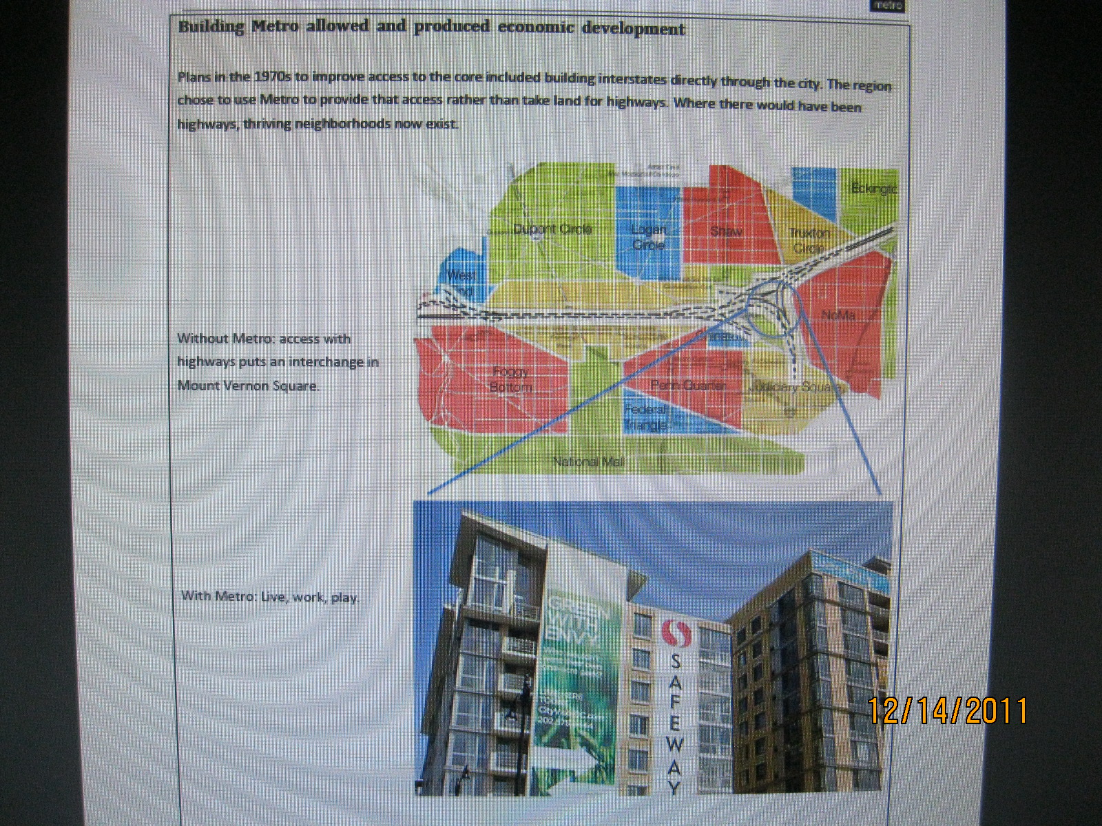
Building Metro allowed and produced economic development

Plans in the 1970s to improve access to the core included building interstates directly through the city. The region chose to use Metro to provide that access rather than take land for highways. Where there would have been highways, thriving neighborhoods now exist.

Without Metro: access with highways puts an interchange in Mount Vernon Square.
Actually beneath the streets and with new development
WMATA would have us forget that the I-66 K Street Tunnel planning came WITH transit planning
With Metro: Live, work, play.
Actually with Metro AND the freeways
In particular, much of the Mount Vernon Square neighborhood would have been lost to a large interchange. At the time, the interchange would have displaced 845 dwelling units and 97 commercial and industrial firms employing 980 people.
Actually not true, the interchange was to be underground, and beneath existing right of way, with some additional land acquisition which would have new development like that now being built. The displacement was quantitatively perhaps none (given the replacement housing within the new development atop), with 148 existing dwellings displaced for the Mt Vernon to 4th Street segment (the 845 figure including the extension to 1st Street NE, including the easternmost block of townhouses demolished about 10 years ago).
As the area has developed, north of New York Avenue, we now have a neighborhood of row houses, small apartment buildings, and churches. The sidewalks are brick and shadowed by tall trees. On New York Avenue, we have several restaurants, bars, and a car mechanic.
The City Vista block (east of 5th, between L and M) would have been parking above the freeway. Thanks to Metro, we instead have a vibrant development: apartments, condominiums, a large Safeway, a mobile phone store, a bank, a hardware store, a variety of restaurants (some with outdoor seating), a gym, and a Starbucks. A farmer's market has opened up a block away. It is a half to three-quarters of a mile to three subway stations, and only a mile to a fourth: Union Station where you can also connect to the Amtrak lines going all up the east coast.
In short, this is a great neighborhood with lots of variety and everything its residents need. Had the region chosen the freeway instead of Metro, we would have lost this neighborhood and its contributions to employment, taxes,and quality of life [sic- see below].

Sources: Map and description of displacement adapted from “District of Columbia Interstate System 1971,” November 1971, DeLeuw, Cather Associates and Harry Weese & Associates, Ltd. City Vista photo: Sean Robertson.

Forgotten is that the rail transit and freeway systems had been designed together.


http://mysite.verizon.net/cambronj/wmata/m80-52.jpg

WMATA Subway Plans Indicate the I-66 K Street Tunnel

1971 DeLeuw Cather Weese study report 
showing intact Mt Vernon Square with I-66 in tunnel beneath


1971 DeLeuw Cather Weese study report 
showing intact Mt Vernon Square with I-66 in tunnel beneath, plus uncovered below-ground interchange to the east with parking lot that would be compatible with a replacement by a building akin to as done above the Center Leg at K Street

Center Leg at K Street- 
WMATA misrepresents the planning as if buildings were not or could not be placed atop freeway area.

http://wwwtripwithinthebeltway.blogspot.com/2007/03/i-66-north-leg-west-k-street-tunnel.html


1971 Freeway Planning Replacement Development


New Development OK with highway traffic on street rather than in tunnel?!
 
WMATA appears to be echoing an inacurate description of the freeway planning seen elsewhere by those acting as if oblivious to the highway history web sites as A Trip Within the Beltway and Scott Kozel's D.C. page at Roads to the Future.


Sunday, December 04, 2011

CSX Virginia Avenue Tunnel- Cross Sections Published

Concept 5 preserves the most space alongside the SE Freeway, thus best facilitating the freeway's lowering/tunnelization, ESPECIALLY if it shifted the new northern tunnel closer to the new southern tunnel, rather then using the existing tunnel's centerline. Concept 5 avoids the waste of filling in a new excavation via making the new cut into a new tunnel, and furthermore preserves part of the existing tunnel's excavation for the outboard portion of the future underground SE Freeway.


The report also includes options of a temporary cut to the north of the existing tunnel, even though that provides less space for lowering-covering the freeway, but may run into issues with the existing elevated freeway's underground piling supports. Concept 2 is essentially CSX's traditional preferred plan, with Concept 5 a recent addition.


Virginia Avenue Tunnel Study
http://www.virginiaavenuetunnel.com/media/uploads/downloads/VAT_Public_Alternatives_Meeting_Presentation_Combined_FINAL_1.pdf

More from JD
http://www.jdland.com/dc/index.cfm/3586/Virginia-Avenue-Tunnel-Project-Concept-Designs-Unveiled/