Saturday, April 21, 2007

1971 D.C. B&O I-70S (I-270) Takoma

I-70S North Central Freeway- Takoma area

District of Columbia Interstate System, by DeLeuw, Cather Associates and Harry Wesse & Associates, LTD, 1971, prepared for the District of Columbia Department of Highways and Traffic, in cooperation with the U.S. Department of Transportation, Federal Highway Administration.

This represents the last formal planning study design for the B&O Low Level Route I-70S Low Level proposal along today's Red Line in the vicinity of the Rhode Island Avenue and Brookland/CUA WMATA Stations.

Including a tunnel segment, this planning for the Takoma Park area segment of the North Central Freeway involved a change in the proposed roadway elevation, replacing the elevated berm configuration (of a pair of 3 lane roadways flanking the existing railroad berm), with a cut (of a pair of 3 lane roadways together along the existing railway berm's east side). Note the building immediately left of the word METRO, which has some space between it and the railway berm, unlike the "Elevation 314" erected there later.

Most of this 1971 design I-70S Takoma tunnel would have been built within the footprint of the demolition of the WMATA Red Line construction. To the south and to the north it would displace a number of houses, including, not insignificantly the landmark Cady-Lee Mansion at the corner of Piney Branch and Eastern Avenue (directions), which was built in 1884 and the northernmost house within D.C. on this railway corridor's east side. While both the 1966 and 1971 plans would have indirectly displaced the houses further to the north along Takoma Avenue in Maryland, only the 1971 plan would have displaced the Cady-Lee Mansion: an absolute NO-NO to anyone aware of its architectural significance.

This 1971 study does not provide illustrations of the connecting Silver Spring segment. I have not seen a drawing of such, and here present the 1966 B&O low level route option, with its tunneled segments in and near Blair Park. Since this 1966 design has southbound I-70S shift to the west side of the railroad to avoid the buildings of Montgomery Community College that face the railroad's east side, my guess is that the 1971 version would have added another tunnel segment to bring southbound I-70S to the east side of the railroad. Doing this would have had I-70S directly displace the houses facing the railroad along Takoma Avenue, which the 1966 plan had I-70S do do indirectly by relocating Takoma Avenue to the east.

1966 B&O Route North Central Freeway
Blair Park/Montgomery Community College

1966 B&O Route North Central Freeway
Takoma, D.C.

Due to the reactionary nature of resentment politics, and the doctrine it here served, no subsequent design modifications were ever formally considered

Friday, April 20, 2007

1971 D.C. B&O I-95 Brookland/CUA (Catholic University of America)- Rhode Island Avenue

I-95 North Central Freeway- Brookland/CUA-Rhode Island Avenue area

District of Columbia Interstate System
, by DeLeuw, Cather Associates and Harry Wesse & Associates, LTD, 1971, prepared for the District of Columbia Department of Highways and Traffic, in cooperation with the U.S. Department of Transportation, Federal Highway Administration.


This represents the last formal planning study design for the B&O Low Level Route I-95 Low Level proposal along today's Red Line in the vicinity of the Rhode Island Avenue and Brookland/CUA WMATA Stations.

These plans would have removed and replaced 34 dwellings in western Brookland near the railroad's east side where this highway route would have ran from the vicinity of Catholic University of America and to the south. Unlike the 1964 and 1960 plans it would spare the historic Brooks Mansion.


It would have furthermore spared Brooks Mansion from the noise of the traffic of this 8-10 lane depressed highway, as this 1971 proposal has this as a cut and cover tunnel extending from near Rhode Island Avenue to a few hundred feet north of Michigan Avenue. Under this plan the space atop would be used for replacement dwellings, retail stores (including a supermarket on the north side of Michigan Avenue), and community uses.

1966 North Central Freeway Study

This general concept of covering I-95 in the Brookland/CUA area also appeared in the 1966 B&O Route North Central Freeway study, though oriented further to the north, extending fully north of the main campus of Catholic University of America, but not as far south as Rhode Island Avenue.

As these plans included highway with railways, the decision to cancel the B&O Route North Central/Northeast Freeway left Washington D.C. with a transportation network that would be less multi-model.

Tuesday, April 17, 2007

B&O (D.C. I-95) Corridor Photos

Looking south of the Franklin Street overpass towards Rhode Island Avenue NE and the Capitol rotunda.

Looking south at the Franklin Street Overpass, from immediately east of RR.

Looking south at the Franklin Street Overpass, from immediately east of RR.

Looking south at the Franklin Street Overpass,
along 8th Street NE on west side of RR.

Note the spans which could accommodate an 8+ lane freeway, even though such a route was not the plan.

Looking south at the Michigan Avenue Overpass, from WMATA Red Line Car.
on the approach to Brookland/CUA Station

With Brooks Mansion at left (which would have been displaced by the 1960 and 1964 plans, and spared by the 1966-1973 plans). Catholic University of America at right (off photo). Note the span to left, which could accommodate an 8+ freeway about where it was planned to run from 1966-1973. The neighborhood of Turkey Thicket which would have been largely displaced by the 1964 plan is left of the bottom photo's view. The 69 remaining dwelling that would have been displaced by the 1966 plan (or 34 for the 1970-73 version) and which were protested by the Emergency Committee on the Transportation Crisis (ECTC) were to the south and slightly south-west of Brooks Mansion, along the east side of the RR.

Please note that the 1960,1964 and 1966-71 plans had I-95 to the east (left) of these views, hence avoiding the open industrial areas to the west along 8th Street NE.

B&O (D.C. I-70S/I-270) Corridor Photos

B&O railroad corridor looking north from New Hampshire Avenue

B&O railroad corridor looking west from Takoma WMATA Station

B&O railroad corridor looking south-east from Takoma WMATA Station

B&O railroad corridor looking north from Takoma WMATA Station at adjacent freight rail

Since these photos were taken, irresponsible planning has placed new dwellings upon these open areas, effectively pinching this corridor, creating a potential railroad-dwelling proximity hazard (with the dwellings at a lower elevation then the freight trains!), and requiring the use of eminent domain for public use. These demolition specials are the entire "Elevation 314" project to the east, and at least a portion of the "Cedar Crossing" project to the west.

Such is what is passed off as "Transit Oriented Development" or "Smart Growth", but which may be called the "New Medievalism.".

The B&O Route North Central Freeway Did

It succumbed to a form of resentment politics.

The B&O Route North Central Freeway was promoted by the Administration of John F. Kennedy via
the report of November 1962, as the replacement of the originally envisioned three separate freeways indicated by 1959 Mass Transportation Plan.

It consisted of a North Central Freeway along the B&O railroad that would be met by the I-95 Northeast Freeway. The North Central Freeway would be I-70S to the north of this junction, and I-95 to the south.

It adopted a different route for the I-95 Northeast Freeway upper right segment of the Y then that of the 1960 I-95 Northeast Freeway study, which adopted the RR route that was later termed the North Central Freeway. It abandoned the route through and alongside Catholic Sisters College property that had been openly opposed by the Roman Catholic Church. Instead it would employ the Fort Drive corridor, shown in the planning from 1963 until February 1973.

The B&O route NCF was undermined by the 1963-64 NCF study. Rather then adhering to the B&O Y Route concept, it studied 37 options, many nowhere near the railroad, and with a recommendation for a route partially along the railroad but with significant deviations in Takoma Park Maryland and Brookland in DC.

In 1966 a supplementary study drew up plans for a B&O Route NCF.

It was undermined by the authorities suggesting that the 1964 plan would be built rather then the 1966 plan. The influential generally pro-highway planning group the Council on the Federal City made much the same mistake of suggesting the 1964 plan for short term expediencies of time and money, in a report of their’s published only weeks before that of the 1966 NCF supplementary study.

It was also undermined by the suppression of efforts to re-open the planning of the North West Freeway, particularly in downtown Bethesda which ended up being largely torn down and replaced with new real estate development induced by the WMATA Red Line Subway, and which would have taken about 74 houses for the Wisconsin Avenue corridor in DC. A January 1965 statement by President Lyndon Johnson that he saw no need in the “foreseeable future” for a Wisconsin Avenue corridor freeway reportedly inflamed opponents of the NCF.

Together, this was basically stating let’s not build a freeway on a more direct route with far less net displacement in a wealthier area, but let’s build one on a longer out of the way route 1/3 mile east of the railroad through Takoma Park taking 471 houses in 1 mile.

Hence most people reacted by simply opposing the North Central Freeway rather then call for a design true to the 1962 proposal. In my review of the papers (Emergency Committee on the Transportation Crisis) at the MLK Library Washingtonian Division, and those (Peter Craig and the Committee of 100) at the GWU Gellman Library Special Collections Division, I found an overwhelming amount of strict opposition, though inspired by the 1964 plan be nonetheless organized around the time that the supplementary 1966 plan was published.

No wonder why Sam Abbott and others would be able to strategically target the NCF via protesting the mere 69 houses in Brookland, just across the railroad from the southern end of Catholic University of America, even though this would ultimately contribute to greater numbers being demolished in Virginia for the Springfield interchange and the Woodrow Wilson Bridge replacement project in Alexandria. Hence, in such a climate of crafted intolerance, official planning efforts to construct significant portions of the NCF as cut and cover tunnel, and to replace and displaced dwellings to avoid a net loss of such were basically ignored as writers appealed to such resentment politics for the basic goal of keeping I-95 away from the area of that railroad corridor.

Will the HAZMAT Railroad Relocation Succumb to Resentment Politics?


Maryland officials oppose the two southerly route options for transferring the Washington, D.C. burden to significantly longer routes through Maryland.

The position of Virginia (if there is one) is not reported, AFAIK.

Washington, D.C. officials favor any choice amongst these three options, whether the 2 significantly longer options through Maryland, or the new tunnel through D.C. along the south (east) side of the Anacostia River.

According to the statement (PDF) given by Joseph Passonneau, the people there will not tolerate this through their community, even though involving an already existing railroad and highway corridor. This suggests that the people there already see their area as having a disproportionate portion of the burden; they have suggested that D.C. spread the burden.

This status quo reminds me of Ben Franklin's statement that "we can hang together or separately," with our Nation's Capital being ruled by a spirit of parochialism.

Monday, April 09, 2007

Maryland Officials Oppose Longer HAZMAT Rail Routes through their state

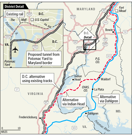
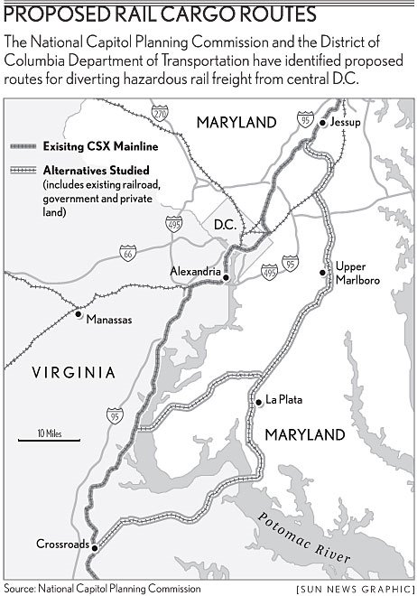
The Two Long Routes Through Maryland

href="http://www.baltimoresun.com/news/traffic/bal-md.rail06apr06,0,1273945.story?coll=bal-local-headlines">http://www.baltimoresun.com/news/traffic/bal-md.rail06apr06,0,1273945.story?coll=bal-local-headlines

There's a difference of opinion between Washington, D.C. and Maryland officials regarding the newly released HAZMAT railroad relocation study, with Maryland officials strongly opposed to two route options that significantly lengthen the route segment in Maryland. From The Baltimore Sun:
The report was praised by the District of Columbia government, which commissioned the report. "This study shows that it is possible to eliminate a serious security threat to the nation's capital," said Emeka Moneme, director of the District's Department of Transportation.

But Maryland Transportation Secretary John D. Porcari said two of the proposed routes were "simply unacceptable" and expressed skepticism about the third.

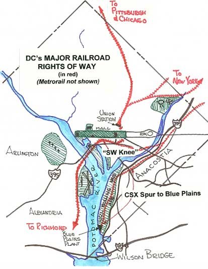
District leaders have long been concerned that the CSX freight line through Washington, which runs just blocks from the National Mall and the Capitol, could pose an inviting target for terrorists. Among other cargoes, the railroad line has carried tank cars with such hazardous contents as chlorine.

The report also ran into political trouble on Capitol Hill, where the No. 2 leader in the House of Representatives expressed concern that two of the proposed routes would run through the growing Southern Maryland counties he represents.

"While I remain supportive of efforts to secure the National Capital Region by reducing the threats posed by hazardous cargo, I would be strongly opposed to any plan that would only shift the potential risk to other parts of the region or that would come at the expense of the communities along the alternative routes," said Majority Leader Steny Hoyer in a statement issued by his office.

The report suggested three routes -- each costing billions of dollars and involving a new crossing of the Potomac River -- to bypass the current bridge near the Jefferson Memorial:

• A tunnel running from the Potomac Yard in Alexandria, Va., to the Anacostia region of Southeast Washington.

• A crossing from Stafford County, Va., to western Charles County, connecting to an existing railroad in Waldorf.

• A route across the Potomac near the U.S. 301 bridge, passing through La Plata on its way to Waldorf.

Porcari, who was briefed on the report last week, fired off a blunt letter accusing the Washington planning commission of ignoring the potential dangers of diverting hazardous cargo through Southern Maryland.

"You have not solved the security problem, but have simply displaced it," Porcari wrote.

Bill Dowd, the commission's director of project planning, rejected Porcari's criticism. He called the objections from Maryland "premature" and denied that Southern Maryland residents would face the same level of threats as District of Columbia now do.

Here's an interesting thread at misc.transport.road