Saturday, May 15, 2010

The Fallacy of the Federal City Council's 'Support' for Washington, D.C. Freeways

The Federal City Council’s Questionable ‘Support’ of D.C. Freeways
with 'support' as this, one can see why the highways did not get built!

Prioritizing opposing delays, meaning support for earlier far more destructive plans rather than wait a few months for an alternative plan.

The Federal City Council was founded in 1954, as an organization focused upon the planning of Washington, D.C. , ostensibly as an alternative to the Committee of 100 on the Federal City, Their web site boasts they involve themselves with the biggest projects – a claim juxtaposed with a picture of a statute of a lion, suggesting an indifference to smaller projects – with a mention of their supporting the construction of the WMATA subway system.

Its first major venture was the SW D.C. ‘urban renewal’ plan’ that included the SW Freeway.

Perhaps its most prominent official amongst the MSM is Donald Graham, executive publisher of The Washington Post: the newspaper that lies about the feasibilities of DC freeways, and which infamously did not report on the 1990s Extending the Legacy South Capitol Mall.

LINK- WP Lies About D.C. I-95

LINK- WP continues to Lie- false claim of 200,000 dwellings when it was but 1,065
LINK- Media Non-Reporting NCPC South Capitol Mall

LINK- Media Non-Reporting Abortion of NCPC South Capitol Mall
Given such a performance, Graham’s presence can hardly inspire confidence in the Federal City Council nor any other entity ostensibly devoted to Washington DC planning.

Unmentioned is their past questionable (Hegelian dialectic style) ‘support’ for constructing a fairly comprehensive inside the Beltway-Washington DC freeway system: note how I-95, I-66 and I-295 are truncated.

Such ‘support’ centered upon their opposition to *delaying* highway construction, as it meant going with highly unpopular, infinitely far more invasive highway designs/routings, rather then far more politically and environmentally sensible designs already on the drawing boards, was self defeating.

This was most true with the mystery of the political subversion of John F. Kennedy’s B&O Route North Central Freeway.  It would have gone alongside Catholic University of America (which really did not want it anywhere near them, with CUA strangely silent on proposals to cover the freeway).  And to this day CUA opposes proposals to cover this railroad corridor, evidencing an attitude that they like CUA being isolated from the neighborhoods to the east.

And it was also true with the Federal City Council's opposition to the K Street Tunnel concept for cross-town D.C. I-66, favoring instead the infamous 1955 plans.

From Freeways in the National Capital Region, by the Federal City Council, April 1966
"... The delaying effects of these new questions extend throughout the entire proposed road network."


And to think that this would be more months before the November 1966 publication of the Supplementary North Central Freeway that essentially followed the John F. Kennedy prescription , and also featured the I-66 K Street Tunnel alternative.
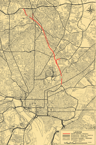

The Federal City Council position was remarkably similar to the Little report except for their spin upon their pessimism, with the former decrying delays and the latter decrying the supposed impracticalities, such as the need to as a start further develop the design of the I-66 K Street Tunnel's connections with the other segments.

1960s Washington, D.C. Freeway Planning Hegelian Dialectic

A Highway Program Designed to Fail

elements:

The 1964 deviation from the 1962 JFK B&O Route NCF concept- undermining public support for a freeway along the B&O corridor, alongside which the most important property is Catholic University of America, and the subsequent additions of design objections absent with the previous plans.

http://wwwtripwithinthebeltway.blogspot.com/2007/05/1964-north-central-freeway-routing_08.html

http://wwwtripwithinthebeltway.blogspot.com/2007/05/1966-north-central-freeway-routing.html

http://wwwtripwithinthebeltway.blogspot.com/2007/05/1971-north-central-freeway-routing.html

http://wwwtripwithinthebeltway.blogspot.com/2007/06/north-central-freeway-most-botched-most.html

http://wwwtripwithinthebeltway.blogspot.com/2009/05/telling-deletion.html

The mid-late 1960s ‘pro’ highway push from organizations as the 'Federal City Council' that prioritized opposing highway construction delays, hence, meaning support for earlier more impactive unpopular plans.

http://wwwtripwithinthebeltway.blogspot.com/2010/05/fallacy-of-federal-city-councils.html

The mid to late 1960s waffling of various officials as late as 1968 to build the earlier (1964) versions of the North Central Freeway.

http://wwwtripwithinthebeltway.blogspot.com/2010/05/significence-of-waffling-on-b-north.html

The lack of much discussion regarding proposals to cover portions of such proposed roads as the North Central Freeway, or the section of I-95 that would have run through the property of the Masonic Eastern Star Home at 6000 New Hampshire Avenue, for the PEPCO route alternative that only became the official route in Maryland between its July 1973 cancellation, and the February 1973 cancellation of the previous proposed routing via Northwest Branch Park that had been the plan since the late 1950s.

http://wwwtripwithinthebeltway.blogspot.com/2010/05/telling-indifference.html


Friday, May 14, 2010

JFK Administration D.C. Freeway System- Other Aspects


A down sized, down scaled highway system


JFK Administration- November 1, 1962

It eliminated the high capacity (8 lane) cross town I-66 North Leg in a new swath alongside Florida Avenue and U Street, replacing said with a 4 lane depressed express street beneath Florida Avenue, ascending to grade at U Street though with depressed underpasses.

It eliminated the high capacity East Leg of the Inner Loop alongside 11th Street NE/SE, effectively replacing it with a spur along Eastern Avenue NE to the I-95 Northeastern Freeway.

It eliminated the Three Sisters Bridge

at page 25:
In the 1959 plan, Three Sisters Bridge was part of an intermediate loop (located between the Capital Beltway and the proposed inner loop) that virtually circled the city. The Agency's studies show no need for the portion of the intermediate loop between the Potomac Rover and The Soldiers Home area. Standing alone, the only purpose of Three Sisters would be to bring trucks and additional auto traffic from Fairfax and Arlington Counties into downtown. For that purpose the bridge is not required.

As of 1957, there were a total of 22 bridge lanes across the Potomac. Projects now under construction, or recently completed, will nearly double the number of lanes, as the following table shows:

The above table does not include the Old Highway Bridge, though the Virginia Department of Highways proposes that the bridge be used with reversible lanes. This would add still another two lanes in each direction for peak traffic.

The Agency proposes two rail rapid transit lines to Virginia, one of which would serve the Three Sisters Bridge corridor. Rapid transit service would not have have been provided in this corridor under the 1959 plan. With such service available, in 1980 a total of over 30,000 people - many of whom would otherwise be using their autos -- would use public transportation from Virginia into the District in the morning peak hour. This is 18,000 more people than use such transportation today, enough to fill 12 bridge lanes. Figure 14 shows the difference in growth of vehicular traffic across the Potomac and compares that with present traffic needs.

The result, as the following table shows, is that under the plan recommended by the Agency, central bridge capacity will be adequate for the needs of motorists in 1980 without Three Sisters Bridge.

This letter of John F. Kennedy illustrates a further evolution of his administration's freeway plans for Washington, D.C.
“…I noted that certain portions of the highway network within the District of Columbia required further study. The guidelines which I believe should be followed in this re-examination are as follows:
The re-examination should focus upon the sections of the highway plans which have from the beginning been the most uncertain and the most controversial- the North Leg of the Inner Loop and the Three Sisters Bridge, both of which involve the manner in which necessarily involve a re-study of those additional portions of the plan which are directly affected by the conclusions reached in the re-examination…”
“ the very large part of the highway program which is not under study can go forward as scheduled.”- John F. Kennedy letter June 1, 1963
Notably the June 1, 1963 JFK letter has him discuss the I-66 North Leg and the [I-266] Three Sisters Bridge as controversial and in need of further study.

Since his Administration’s November 1, 1962 report had down-scaled the former while unequivocally excluding the latter altogether, his June 1, 1963 letter can be taken to suggest that JFK had become receptive to considering some sort of road alternative to the previous North leg proposals, and to the Three Sisters Bridge in some form as parts of the future Washington, D.C. road network.

Proposed I-266 Three Sisters Bridge between Virginia and Washington, D.C.
pointing at Georgetown University


JFK Administration Gave us the B&O North Central Freeway Concept

Recommendations for Transportation in the NATIONAL CAPITAL REGION Finance and Organization: A Report to the President for transmittal to Congress ,the NATIONAL CAPITAL TRANSPORTATION AGENCY, November 1, 1962

at p 29:
The 1959 plan proposed three radial highways between downtown and Montgomery County and western Prince Georges County: one in Northwest, a second in North Central and a third in Northwest Washington. Considerable controversy has developed over all three routes, but in the Northwest has generated by far the most controversy.

It is the Agency’s view that the North Central and Northeast freeways should be brought into the District and joined as a single route connecting with the recommended downtown freeway system and that the George Washington Memorial Parkway be built as planned. This highway system and the high speed raid transit service in Northwest, North Central and Northeast Washington will more than accommodate predicted traffic
at p 44:
Routes 70S and 95 in the District of Columbia and Maryland

The Third Street Leg will be extended along New York Avenue to 9th Street, N.E. From there the route will turn and follow the Baltimore & Ohio Railroad tracks towards Silver Spring. This will be the means of bringing Interstate Routes 70-S and 95 into the city from Maryland and of serving the central and eastern portions of Montgomery County and the western portions of Prince Georges County. Freeway service between downtown and western Montgomery County will be provided by the George Washington Memorial Parkway and the Potomac Freeway.

The North Capitol Street Expressway from Route 70S to downtown is an essential part of the freeway network in this area.

As pointed out in Chapter III, the combination of these freeways, improvements in arterial streets, and rail rapid transit lines in the northwest and north central corridors will provide all the capacity needed by 1980 for auto, truck and public transportation trips between Montgomery Counties and the District

Significance of Using B&O Route. [italics original] Use of the Baltimore & Ohio Railroad corridor to bring Routes 70-S and 95 into the city is the key to meeting the need for additional highway capacity in northern Washington, Montgomery County and northwestern Prince Georges Counties and at the same time avoiding the substantial relocation of persons, loss of taxable property and disruption of neighborhoods that would result from construction of the Northeast, North Central and Northwest Freeway proposed in the 1959 plan. Further savings are realized by placing the rapid transit line to Silver Spring and Queen’s Chapel in the same railroad corridor.

B&O Route North Central Freeway in green
along the northerly Metropolitan Branch RR


Following this November 1, 1962 report, John F. Kennedy issued this letter dated June 1, 1963.
The John F. Kennedy letter of June 1, 1963 enumerates the cross town I-66 North Leg and Three Sisters Bridge as the most controversial segments require further study

“…I noted that certain portions of the highway network within the District of Columbia required further study. The guidelines which I believe should be followed in this re-examination are as follows:

The re-examination should focus upon the sections of the highway plans which have from the beginning been the most uncertain and the most controversial- the North Leg of the Inner Loop and the Three Sisters Bridge, both of which involve the manner in which necessarily involve a re-study of those additional portions of the plan which are directly affected by the conclusions reached in the re-examination…”

The very large part of the highway program which is not under study can go forward as scheduled.”- John F. Kennedy letter June 1, 1963

The B&O Route North Central Freeway, which is not mentioned above as then being controversial, was about to undergo its initial engineering study, commissioned by the relevant authorities in Maryland and the District of Columbia, with its report released October 1964.

That report would seriously undermine the B&O route concept by essentially excluding it.

That report did not study a single option that followed the B&O RR for its entire route, instead it considered an upwards of 37 routes basically all over the map in a vast band between 16th Street and the Masonic Eastern Star property at 6000 New Hampshire Avenue NE.


LINK- Highway Routing Mystery 1964

LINK- 1964 North Central Freeway

LINK- 1964 North Central Freeway Engineering Study

LINK- 1966 Supplementary Study Report North Central Freeway


Monday, May 10, 2010

JFK I-95 Dedication: November 14, 1963

Outside the Beltway, between Baltimore, Maryland, and the Delaware line


http://www.jfrederickandsons.com/delawarehistory/1963.html

On November 14, 1963, President John F. Kennedy dedicated the Delaware-Maryland Turnpike, the first completed section of I-95. The ribbon-cutting event for the 59-mile strip of highway would be Kennedy's last appearance at a public works project, prior to his assassination eight days later. Delaware officials appearing with Kennedy were Governor Elbert N. Carvel and Representative Harris McDowell.
Also present, Robert Moses.

John F. Kennedy; 35th U.S. President
http://www.presidency.ucsb.edu/ws/index.php?pid=9522

Remarks at the Dedication of the Delaware-Maryland Turnpike.


November 14, 1963

Mr. Moses, Governor Carvel, Governor Tawes, Congressman Fallon of Maryland, Congressman McDowell of Deleware, Mrs. Brewster, representing Senator Brewster, who stayed on the Senate floor today, distinguished guests, ladies and gentlemen:

It is a pleasure for me to join the citizens of Delaware and Maryland in opening this new highway. This highway has been built by the dedicated effort of the citizens of these two States, and it joins a great interstate highway which represents a cooperative effort between the United States Government and the people of the various States, through which this long ribbon will pass.

It symbolizes, I believe, this highway, first of all, the partnership between the Federal Governement and the States, which is essential to the progress of all of our people; and secondly, it symbolizes the effort we have made to achieve the most modern interstate highway system in the world, a system which, when completed, will save over 8000 lives a year and $9 billion in cost. And third, it symbolizes the effort which we are giving and must be giving to organizing an effective communication system here in the United States of America.

No industry has a greater impact upon the Nation and no industry has a greater opportunity to affect our economic progress. This administration has proposed a new, comprehensive, national transportation policy, calling for an examination of the relationship between highways, rails, air routes, and water routes, and our goal is the development of the most efficient, economic, and the safest transportation system for all of our people.

Finally, this highway symbolizes a coordinated effort which is consistent with the approach which we must have to the problems in this section of the United States, for it may be only a few years when the whole area, stretching from Washington to Boston, will be one gigantic urban center. We have now undertaken a comprehensive study of all of the transportation needs which this area of the country will require in the coming years. But highway planning is not enough.

Already one-third of the people of the United States live in the 15 States through which this highway will pass. By the year 2000, these States will need to find housing and parks for 23 million more people, an increase of roughly 50 percent in less than 40 years. They will need schools for 6 million more of your children. They will need hospital and nursing homes for some 8 million men and women over the age of 65, compared to 4 1/2 million today. They will need to provide an additional 2 billion gallons of water every day.

So we must clean these rivers and we must get fresh water from salt water. These are some of the facts which the people of the Northeast must face, and the State governments must face them with them, and the Federal Government must take the lead. They may be facts which some would prefer to ignore. They may be facts which some would prefer to forget, but if the United States of America, and particularly the Northeast United States, these 15 States, are going to move ahead and provide a better life for the people of Delaware and the people of Maryland, and the people of the United States, then we are going to have to do something about it.

Because people several years ago made the plans and took the initiative, this highway is now being dedicated. I hope in the year 1963 we will again take stock of the needs of the country over the next decade and we will begin today, this year, this decade, the things which will make this country a better place to live in for the rest of this century.

I congratulate you, the people of Delaware, the people of Maryland, and the people of the United States.

Thank you.

Friday, April 30, 2010

The Fallacy of NOT Building D.C. I-95

Questioning Reality

from http://continuingcounterreformation.blogspot.com/2010/04/dcs-monumential-indicator.html

That things where not what they were popularly presented as being was something I began thinking about in 1972, at the age of 9, traveling with my family by automobile to Washington, D.C., and first encounter this paradox with regard to the I-95 ‘stumps’.

Supposedly, I-95 was stopped at the Beltway as a ‘white mans roads through black mans’ homes’.

Yet clearly juxtapositioned with this stopped highway is its physically clear existing right of way of a 250 foot wide power line right of way pointing towards this Union Station’s northern B&O Metropolitan Branch railroad industrial corridor.

I-95 ‘stub’ roadways just inside the Beltway, alongside parallel PEPCO right of way.

That was some ‘white mans road through black man’s home’ with its wide open 250 foot wide PEPCO power line right of way extending to some 1600 feet from the DC line at New Hampshire Avenue, before continuing another 1600 feet to connect with the B&O Railroad route.

Un-built inside the Beltway & D.C. I-95 via the PEPCO-B&O RR Route,

National Archives II at right

This is THE logical route for inside the Beltway I-95, for its use of existing right of way and for its proximity to New Hampshire Avenue and by extension the east west Missouri Avenue providing superior serviceability into northern Washington, D.C..

As planned by 1973, this route for inside the Beltway I-95 would have taken about 0 dwellings in Maryland, and clusters of 23 and 5 near the north side of New Hampshire Avenue, just inside D.C. flanking the open field of the Masonic Eastern Star Home at 6000 New Hampshire Avenue, and then another 34 at the western edge of Brookland.

The numbers are so low because of the extensive re-use of existing corridors and right of ways- namely the PEPCO right of way and the B&O Metropolitan Brach RR corridor with its lightly developed industrial strip providing the space to grade an 8 lane freeway, with little need to displace residential dwellings- with that for the I-95 segment of the B&O North Central Freeway limited to 34, as per a 1970 DCDPW design revision reducing it from the 69 of the 1966 design.

Completing I-95 all the way from its ‘stumps’ at the Beltway to New York Avenue, as designed by 1973 would have displaced a total of some 57 dwellings- a figure comparable to that taken for constructing the – mile long Inter Counter Connector – miles to the north in Maryland, or the reconstruction of the I-95/I-495 Beltway interchange in Virginia – while serving some 220,000 vehicles of people daily (the 1960 design meanwhile would have displaced some 1,095 alone).

See how the Washington Post LIES about this route:

http://wwwtripwithinthebeltway.blogspot.com/2007/01/washington-post-lies-about-inside.html

Completing its continuations to the portions of the Washington, D.C. that were built – the I-95 North Leg East connecting to the I-95 Center Leg, and the I-295 East Leg connecting to the SE Freeway – as designed by 1971 would have respectively displaced 600+ and 172 dwellings.

This is where the most dwellings would have been torn down (and replaced with new housing).

Yet the biggest protests against “white mans roads through black mans homes” occurred at the site of the proposed I-266 Three Sisters Bridge alongside Georgetown University (that would have displaced 0 dwellings), and at the area of the B&O Route I-95 North Central Freeway in Brookland alongside Catholic University of America, that would have displaced 34 as per the 1970s and later planning, or 69 as per the 1966 plan.

Meanwhile, such issues of mitigation as the increasing use of the existing corridors – earlier planning took far more of a lets cut an all new swath through dwellings and parklands – and that of cut and cover tunneling, containing noise and pollution while reclaiming surface land for other uses, were oddly “forgotten.” (As a historian of the planning of Washington, D.C.’s – discuss matter of finding nothing about the 1966 plan’s proposal to cover the I-95 North Central Freeway alongside the main campus of Catholic University of America, nor any objection when the cover was deleted.)

Things took on a clearly Hegelian dialectics turn by the mid 1960s with the political undermining of the B&O route that had been proposed by the November 1, 1962 Kennedy Administration report.

1959 proposal with 3 separate northern radial freeways


1962 Kennedy Administration proposed Washington, D.C. interstate highway system with 2 into 1 “Y” route along the B&O RR

Initial North Central Freeway study: 1963-1964- making a mockery of JFK’s B&O Route NCF


John F, Kennedy letter June 1, 1963

“…I noted that certain portions of the highway network within the District of Columbia required further study. The guidelines which I believe should be followed in this re-examination are as follows:

The re-examination should focus upon the sections of the highway plans which have from the beginning been the most uncertain and the most controversial- the North Leg of the Inner Loop and the Three Sisters Bridge, both of which involve the manner in which necessarily involve a re-study of those additional portions of the plan which are directly affected by the conclusions reached in the re-examination…”

“ the very large part of the highway program which is not under study can go forward as scheduled.”- John F. Kennedy letter June 1, 1963

Not included in the list of the controversial sections of the highway plans, and thus amongst those which 'can go forward as scheduled' would include the B&O Route North Central Freeway.

LINK- the subversion of JFK’s B&O North Central Freeway

LINK- North Central Freeway Most Needed Most Botched

LINK- North Central Freeway 1964 Highway Routing Mystery

Illustrations: Sam Abbott 1964


The 1964 ‘recommended route’ (Railroad East-Sligo) would have displaced 471 such houses within Takoma Park, Maryland, for the I-70S segment; this town was established by a developer Benjamin Franklin Gilbert in 1883 along the then recently constructed B&O Metropolitan Branch RR into northern Washington. D.C.; the 1.1 mile segment of this 1964 plan had it deviate ¼ of a mile away from said RR upon a longer more out of the way route then simply following the RR: far more invasive then necessary for creating the North Central Freeway.

The negative popular response that would subside with the subsequent supplementary North Central Freeway engineering study released in November 1966 (that essentially followed the 1962 Kennedy plan), would be re-kindled by various officials waffeling between the 1966 and 1964 designs, as late as 1968; included in that was the supposed highway 'advocacy' of the Federal City Council with its highly questionable prioritization against delaying highway construction, hence meaning supporting the 1964 plan over the 1966 plan in order to start construction a few months sooner. That amount of time, would be sufficient to reverse the official positions of the U.S. National Capital Planning Commission, and the D.C. City Council.

Letter to Maryland Governor Agnew, 1967 on how waffling on North Central Freeway planning was inciting opposition.

Citizens of Takoma Park and Silver Spring had reason for their demonstrations of bitter dissatisfaction with the highway authorities of your predecessor's administration. After we had been given reason to believe that the causes of our protests had been in at least some part overcome, the matter now threatens to break into renewed bitterness. I am sure you will wish to avoid this as much as many of us.

We showed that the methods of traffic projections which were claimed to justify the North Central were fallacious, the results in error by as much as 400 percent. Our contention was tacitly admitted in "re-studied" versions of the proposal made public last year, sharply reducing the original plan of 5 lanes each way.

The re-studied proposal also tacitly admitted that the route first proposed was needlessly, even carelessly if not ruthlessly, destructive of our communities. The new version hugged both sides of the existing Baltimore and Ohio railway, thus avoiding a new swath of destruction to divide our communities and sharply reducing the number of homes to be taken.

The reduced, re-routed proposal was made public last year with endorsement of D.C. And Maryland highway authorities. The D.C. Portion was forced through the National Capital Planning Commission by votes of representatives of the D.C. Highway Department and of the U.S. Bureau of Public Roads. From this we concluded, reasonably enough, that the highway authorities of the two jurisdictions (Maryland and D.C.) had reached a firm understanding with the Bureau of Public Roads.

Many of us were therefore astonished and aroused to preparations for renewed protests when Washington newspapers recently reported that the Bureau has acted to open it all up again. We have not found the Bureau forthcoming with candid information, but the press articles intimate an intention to force Maryland to accept modifications of route or design ostensibly "cheaper."

The result is that the whole controversy, which had been somewhat quiescent, is beginning to agitate the communities again. I can assure you this is so, for although I recently resigned chairmanship of the Metropolitan Citizens Council for Rapid Transit and write this simply as an individual citizen who wishes your administration well, I do remain in close touch with neighborhood sentiment on transportation-related issues.

As Governor of our State, you are in position better than we as private citizens to require straightforward answers from the Bureau of Public Roads. You can also insure that the Maryland State Roads Commission refuses to go along with divisive proposals which these communities will regard as cause for new protests.

You can make yourself even better appreciated here by doing both, and by supporting the earliest and most extensive development of rail rapid transit. Will you do so?


The North Central Freeway segment through Takoma Park, Maryland was for I-70S (I-270); the I-95 segment was further south.

Such mis-managment of the highway program made perfect sense when the route is along the railroad passing alongside Catholic University of America, and with the most logical connecting segment to the power line right of way -- the PEPCO route officially unconsidered until 1971 and only adopted for a few months in 1973 prior to the extension's outright cancellation that July -- running through the Masonic Eastern Star property at 6000 New Hampshire Avenue NE.)

LINK- RR Industry law firm Covington & Burling paid ECTC to riot at DC City Council

The only place along the route where I am aware of a solitary tree standing in the middle of the route is that within the field of the Masonic Eastern Star Home at 6000 New Hampshire Avenue NE

Forgotten in all of the group ‘think’ regarding doctrinaire hatred of urban freeways and love of urban railway REGARDLESS OF DESIGN*, is the latent monumental beauty expressed by Union Station as the headpiece of a northeastern linear park atop a set of railway and highway tunnels literally pointed at the head of the beast

(*aka the existing status quo that an underground highway with parkland atop is bad but placing the traffic simply upon the surface streets or way out on the Beltway is good, along with that of splitting the poorer areas of DC apart by surface railways, along with a disproportionate amount of the traffic through SE of the Anacostia River.)

I call it ‘Grand Arc’

Alas, the political pyramid favors blotting this potential majestic thrust in favor of apparently piece-meal appearing projects, for this helps obscure comprehending JD’s ‘King of the world’, by creating the illusion that the government is too weak to organize its Capital City. Note not only the new buildings atop, but also alongside, particularly at the picture’s bottom.

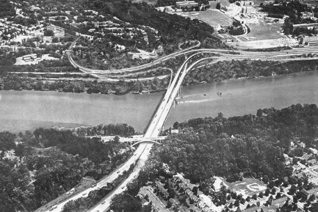
Urban Highways Underground

http://cos-mobile.blogspot.com/2008/02/going-below-big-roads-below.html


'Artspace' Demolition Special April 30 2010 Groundbreaking

Blocks the right of way of the Grand Arc Mall Tunnel-
mis-located "artspace" project blocks public space

Also see: The Fallacy of NOT Building D.C. I-95
http://wwwtripwithinthebeltway.blogspot.com/2010/04/fallacy-of-not-building-dc-i-95.html

Dance Place


OPEN LETTER to artspace:

The new artspace center in Washington, D.C. is too close to the railroad corridor- DC's only major transportation corridor, and is in space needed for a multi-model solution for handling our transportation needs:

http://wwwtripwithinthebeltway.blogspot.com/2008/02/extending-legacy-with-grand-arc.html

http://wwwtripwithinthebeltway.blogspot.com/2008/12/under-selling-b-metropolitan-branch.html

Please let this serve as formal notice that your project is mis-located (should be re-located further from the corridor), and that in its current location, it should be demolished- as should any such developments placed too close to the corridor.

I understand that our government has totally gone apostate in defending the public interest regarding transport.

However, as a private citizen I want you to know what you are doing by supporting this unconscionable chock of this important transportation corridor.

Please inform anyone involved in this project of its demolition special nature.

I totally support the use of eminent domain for public use to remove the mistake that ground was broken for today.

Either relocate the project, or be emotionally prepared to see its demolition- assuming that we get a government for the people rather then the elites that we have allowed to abort the South Capitol Mall.

http://wwwsouthcapitolstreet.blogspot.com/2007/12/south-capitol-street-frederick-douglass.html

http://continuingcounterreformation.blogspot.com/2008/07/jesuitical-medievalist-government.html


Sincerely

Douglas A. Willinger
A Trip Within The Beltway

Be sure to explore the tags "North Central Freeway' and "Highway Routing Mysteries"

8th Street NE facing south, with lightly developed rail-side industrial properties at left


Project was assisted by the D.C. Mayor Fenty.
http://www.beinkandescent.com/articles/136/bognet-construction-will-build-brookland-artspace-lofts-affordable-apartments-and-gallery-space-for-dc-artists

Jennifer: Tell us a little more about what the Brookland Artspace Lofts in D.C. will feature.

Heidi: It will have open interiors, underground parking, performance areas, wide hallways and large elevators so the artists can easily transport their artwork around the building. It will also feature a mosaic tile installation that will be provided by community volunteers, and a “green” roof that will be installed as a community service project.

Jennifer: I know that you worked closely with the D.C. government to make this project happen.

Heidi: That’s right. Discussions about the project began in 2006, when the leaders of Artspace worked with the D.C. Department of Housing and Development, then subsequently with D.C. Mayor Adrian Fenty (pictured right).

The government had developed a policy that would direct D.C. agencies to work together to create and fund art projects that act as an effective tool for economic revitalization. The Brookland Artspace Lofts are a result of that initiative.

Jennifer: I understand that the District’s Department of Housing and Community Development (DHCD) will provide $10.4 million in stimulus funding. Is that correct?

Heidi: Yes, and that includes $1 million in low-income-housing tax credits for the role Artspace is playing in revitalizing the Brookland neighborhood.

This is not the first time that Fenty has committed an act of planning malfeasance; another was the "Elevation 314" apartment house built within the corridor right of way zone (of this same railroad) .

Fenty is a complete idiot with pushing/promoting/accepting these mis-placed development projects. If he is so blind to something as apparent as this, how can people trust his judgment overall?

Of course when this planning malfeasance is brought to his attention, he can only say "shut up" - as there is no defense for this planning malfeasance.

Alas, there is no prosecution of officials such as Fenty, who betray the public's right of way interest.

http://cos-mobile.blogspot.com/2008/07/homeland-security-goal-would-be-better.html