Monday, April 19, 2010

Planning in a Vacuum- CSX-SE Freeway Tunnelization

With Virginia Avenue to be torn up anyway, what about something more comprehensive?


How will the CSX tunnel expansion project affect a future tunnel project to replace the existing elevated SW-SE Freeway?

Proximity Demand Coordination- yet were where the Feds?

Why was this corridor’s planning languishing as EYA and others rushed in to develop up against the right of way?

Note the close proximity of the SE Freeway’s transition from elevated berm to open viaduct in order to cross the mouth of the Virginia Avenue Tunnel, with the connections at left with the interchange with the Center Leg and the SW Freeway.

Note how the viaduct portion over South Capitol and New Jersey Streets is entirely south of the CSX railroad, before swinging to the railroad’s north side at 1st Street SE

That was how the original 1955 Inner Loop design had it, shown here with the original East Leg along 11th Street.

This 1961 rendering below at its top shows an un-adopted routing of the SE Freeway, along the Virginia Avenue railroad tunnel’s southern side. I have not yet seen a rendering of this option for the segment further east (with this rendering failing to show even the connections to the 11th Street Bridges[s]).

Given their proximity and grade requirements – freeways can tolerate 5-7 % while heavy rail can only take 1% -- and the short distances to the 11th Street Bridges – the under-grounding of the SE Freeway is surely a project to coordinate with that for reconstructing the railway, such as that now announced to start construction by 2011.

Here’s a close of the 1955 design.

Here’s what was built.

And here’s a close up where the freeway crosses the RR at the start of the latter’s tunnel


Note the proximity of the support columns for the SE Freeway viaduct.

Photos by Matt Johnson

The CSX Project:

Reconstruct the Virginia Avenue railroad tunnel with greater height and width; digging it lower and widening it with a temporary trench to the south that is later filled in.

How:

- Dig a trench about 25 feet wide along the existing tunnel’s southern side for diverting the trains throughout the reconstruction
- Remove the roof and at least one of the lateral walls, excavate the floor 3 or 4 feet lower and widen to 40 feet.
- Route trains into reconstructed tunnel and fill the trench

Not yet known to me is:

- whether or not both of the existing tunnel walls are replaced/relocated
- whether the center-line shall remain the same, or is shifted
- the method of construction, particularly the method of securing the ‘temporary’ trench- perhaps a less expensive yet noisier to construct pile driving instead of a more expensive yet quieter to build and more permanent slurry wall?

Idea:

Facilitate the reconstruction-restoration of Virginia Avenue with a well thought overall plan encompassing the CSX project and a future underground SE Freeway

According to this communiqué from Capitol Hill:

- The District comprehensive plan stipulates that the railroad tunnel expansion should only occur in conjunction with the tunnelization of the existing parallel SE Freeway

Since this segment of the SE Freeway is an elevated berm-way, framed by vertical concrete retaining walls, its burial will require some space, particularly while maintaining traffic to and from the reconstructed 11th Street Bridges and the SW Freeway.

Apparently CSX shall pursue this tunnel augmentation project as inexpensively as possible, meaning:

- open trench construction (without a street deck), except for the cross streets
- replacing only one of the existing tunnel’s lateral walls, which given that era’s generous ‘over-engineering’ could be incorporated into the reconstructed tunnel, hence shifting the mainline fully to one side or the other.

With the ‘temporary’ trench to the south and the option of replacing one or both of the existing tunnel walls, the likeliest option is that of shifting the center-line to the north, closer to the elevated SE Freeway, using the existing southern RR tunnel wall to segregate the trench from the RR tunnel construction.

But given the cost premium of underground construction particularly with excavation, is simply configuring this project via filling in this space really its most cost effective and productive potential use?

What consideration has been given to any sort of coordination between the future stated goal of an under grounded SE Freeway tunnel from South Capitol Street to 8th Street with the CSX project?

Likewise, what about that concerning the just started 11th Street Bridges Project?

Let alone the accompanying mandatory project to so bury the SW Freeway, given that its meeting with the SE Freeway is an elevated viaduct, meaning that any CSX-SE Freeway Tunnel project would otherwise require its SE Freeway Tunnel be built while retaining the existing elevated berm-way SE Freeway until the realization of the full SW-SE Freeway Tunnelization Project. Clearly thus they must be planned all together, yet where’s any indication of that?

Photo by Matt Johnson
SE Freeway berm-way at left

Instead we have a situation with questionable decisions to extend new real estate development – aka buildings full of peoples’ dwellings – in extra close proximity to such major transportation corridors. The plethora of simply bad decisions as:

- Failing to reserve a strip of the Cappersburg properties along the along the area closest to the Virginia Avenue RR tunnel

- Failing to reserve a strip of the properties along the entire southern side of the SW Freeway, especially between 9th and 7th Streets with the 1999 construction of the ‘Capital Square’ townhouse project.

- Approving the ‘Capital Square’ project with its northernmost row of 28 townhouses- complication the future under-grounding of the SW Freeway via creating a right of way band pinch.

- Selling the interchange land for the northbound I-395 Tunnel on ramp between Massachusetts Avenue and K Street for the demolition special "Golden Rule" apartment house, blocking the on-rap and potentially creating a dangerous migratory pattern of elderly citizens carrying home their groceries from the nearest food market - also named 'Golden Rule' for the association with the Bibleway Church at the northern end of I-395.

- Allowing the transportation corridor reconstruction to lag behind decisions by entities as EYA to construct new dwellings

It is hardly a flattering indication of those within the government.

Given this track record, anyone is going to have to ask if the CSX project, in its current form, present the most optimal ‘defragging’ of this right of way- or might its cost savings as so configured, be more than offset by it increasing the costs of the SE Freeway Tunnel project?

SE Freeway Physical Realities:

Burying the SE Freeway is going to require some space, particularly with the need to maintain traffic throughout the construction to and from the reconstructed 11th Street Bridges.

Along its southern side is Virginia Avenue, with the RR tunnel beneath.

It has underpasses for cross streets.

It connects to its west to the SW Freeway, with the configuration being an elevated viaduct before a slightly depressed segment between 7th and 9th Streets Sw

It connects to its east with the 11th Street Bridges with a brief continuation to a set of tunnels beneath Barney Circle where it is truncated since 1974.

Situate the CSX Project to facilitate SE Freeway under-grounding, while preserving the easements for its connections to an under grounded SW Freeway, the already underground Center Leg and a future South Capitol Street Tunnel.

This is essentially ‘defragging’ the existing corridor right of way by assembling the needed contiguous space for constructing the future eastbound cut and cover SE Freeway tunnel before demolishing the existing elevated freeway to construct the westbound twin.

Such a stage ability is required to reduce construction impacts, and is subverted by the government’s apparent inability to just say no to developer projects located closer and closer to a right of way (such as the infamously placed row of EYA Capitol Square townhouses alongside the SW Freeway).

Basic options include:

- Cut and cover CSX tunnel shifted south, re-using existing northern tunnel wall, creating space for future eastbound cut and cover SE Freeway tunnel

- Cut and cover CSX tunnel shifted north, re-using existing southern tunnel wall, and thereby in the median space for future cut and cover SE Freeway tunnel

- Drilled railroad tunnel directly beneath eastbound lanes of SE Freeway berm, allowing full Virginia Avenue right of way for the future eastbound SE Freeway Tunnel

- Full Virginia Avenue right of way cut and cover tunnel accommodating the expanded railway and future eastbound SE Freeway tunnel

These decisions can’t be avoided.

Capitol Hill communities will need to be vigilant, including being fully willing to sue the government for failing to plan.

Sunday, March 28, 2010

Eisenhower's Burning Tree Commute Desire?

An Eisenhower favorite hang out, immediately within the I-495 Capital Beltway


Recently a controversy emerged amongst historical researchers of Washington, D.C.’s truncated freeway system. It is centered upon claims that Dwight Eisenhower opposed urban freeways; these are based upon a story of his encountering freeway constructing in either in the NW area of Washington D.C. (which did not exist, e.g. the West Leg by the Kennedy Center started construction in 1961 or later) or just to the north of the construction of the circumferential Capital Beltway (which was under construction, though not an urban freeway). See the conversation thread here.

Perhaps seeing a portion of the Capital Beltway under construction through the Bethesda area inspired Eisenhower to think about these road’s right of way requirements- a thought making me ask if he ever questioned the use of eminent domain particularly as being used at the time of his Presidency in SW Washington, D.C. which leveled far more buildings then did the right of way for the SW Freeway which started construction by 1959.

The Eisenhower library papers cited indicate that he had misgivings about urban freeway planning, specifically that through the “congested parts of the city”, calling for a subsequent study: a fact pattern of the extensive freeway system of the 1959 ‘Mass Transportation Plan’ displacing the dwellings of some 33,000 people that fits with the subsequent U.S. Presidential Administration of John F. Kennedy’s November 1, 1962 report for a smaller though still continuous freeway system with I-66 and I-70S into, and I-95 through the District with far less negative local impacts.


However, what primary resources indicate that Eisenhower opposed urban freeways unequivocally? Deleting urban segments from the early stages of the construction of the national interstate highway system does not necessarily translate to never having urban segments, particularly as definitions of terms as ‘urban’ or ‘congested’ and conceptualizations of feasibility may vary, as can those of routing and design for reducing impacts?

Would Eisenhower agree, in the case of the Washington, D.C. area, of having I-95, I-66 and I-270 never extend within the Capital Beltway, nor favor today’s status quo of the past few decades of I-95, I-66 and the SE Freeway’s truncations?

The following suggests not.

Concerning the recent conversation about Eisenhower’s position on urban freeways, here’s what I just located, page 2 of a letter by Peter S. Craig (Gelman Library Special Collections)

The big question is who ‘in the White House’ is responsible for this pressure.

One member of the Executive Committee of the Northwest Committee for the transportation Planning reports that he heard the President himself wants the Wisconsin Avenue corridor because he was irritated by the traffic congestion in getting to Burning Tree Country Club.

All White House contacts should be pursued in an effort to pin down the source of pressure on Welling, Tallamy and others to push through the Wisconsin Avenue corridor routing.

A google search of ‘Burning Tree Country Club’ led me to this in Maryland, just outside NW Washington, D.C., and immediately inside the Capital Beltway segment between the western I-270 spur and the Potomac River.

It is something that comes up frequently in searches about Eisenhower, as he evidently spent a great deal of time there, as an avid golf enthusiast said to have played some 800 games throughout his 8 years as U.S. President, alongside many powerful people. Just 'google' the terms 'Dwight D. Eisenhower' with 'Burning Tree Country Club'.


Constructing the Wisconsin Avenue corridor segment of the NW Freeway, as planned in 1957 southwards from the Pooks Hill interchange of the eastern spur of today’s I-270 and the Capital Beltway – miles to just south of a set of cut and cover tunnel underpasses beneath Tenley Circle, would have displaced 74 houses within D.C., and an indeterminate number in Bethesda, Maryland, largely within the footprint of the WMATA induced re-development that leveled much of that downtown.

Responding to barriers further south of denser, older Georgetown, and the political ban upon routing via the Glover Archbold Park (with only a brief cir 1957 consideration of a ‘Cathedral Heights Tunnel’- details unknown to me other then it running somewhere near the National Cathedral), official planning by 1958-59 went with planning the NW Freeway’s southern segment as the ‘Cross Park Freeway’. This would swing due east from the Wisconsin Avenue corridor just before Fannie Mae, skirting the northern edge of the Sidwell Friends School-Cleveland Park area, crossing below Connecticut Avenue and across Rock Creek Park to the Mt Pleasant area along Fort Adams Road and Irving Place before turning south some 500 west parallel to 14th Street, meeting the east-west I-66 North Leg of the Inner Loop between T and U Streets.


Almost all of this plan’s building displacement would be to Rock Creek Park’s east, in Mt Pleasant. Yet all of the 1959 revisions re-specifying certain segments as tunnels would be to the west, with the depressed Fannie Mae-Sidwell Friends and Cleveland Park-Connecticut Avenue segments respectively as drilled and cut and cover tunnels, though to east, only considering the options of sloped embankments versus retaining walls, despite the denser development resulting in greater displacement and greater local separation by the addition of the uncovered freeway.


The opposition from to the west was instrumental in stopping the Cross Park Freeway planning (and indeed any freeway within NW D.C. west of 16th Street NW: the eastern edge of Rock Creek Park), namely that of Peter S. Craig, Cleveland Park resident, and railroad industry with the Washington, D.C. law firm Covington & Burling (co-founded in 1919 by railroad industry attorney Edward Burling), along with the ‘Committee of 100 on the Federal City’ (founded in 1924 upon the popular excitement about constructing the McMillian Plan’s West Mall-Lincoln Memorial, by Burling’s brother in law, Frederic Adrian Delano who sat on the original US Federal Reserve in 1914, and was uncle to 32nd U.S. President Franklin Delano Roosevelt).


Stopping the NW D.C. Freeway planning stopped any further design evolution – something conceivably advance able with the idea of a subsequent look at a deep drilled tunnel in the Cathedrial Heights general area and/or parallel to Glover-Archbold Park that would be significantly longer then that to skirt Sidwell Friends, though providing a significantly shorter direct route.

That would not necessarily stop freeway planning, with a faction from Bethesda pushing the idea of constructing the 1959 Mass Transportation system’s North Central Freeway along Georgia Avenue- an idea with far greater impacts then the 1959 NW – Cross Park Freeway.

Meanwhile another faction or factions favoring I-70S uphill parallel (via the former trolley right of way) to the Canal Road corridor- seemingly a more direct route from the White House to this Burning Tree Country Club.

Clearly there is far more to this story to discover.

Friday, March 19, 2010

SW Freeway to Center Leg/Capitol Hill Signage

I wrote in my last article that the placement of EYA 'Capitol Square' townhouse development project, particularly its northernmost row of some 28 houses with their rear walls some 16 or so Linkfeet from the SW Freeway retaining wall stood as mute testimony to the non-planning of the very federal agencies headquartered only a few hundred feet to the north- the U.S. Department of Housing & Urban Development and the U.S. Department of Transportation visible in the above picture.

The following photos from a piece about this area of the SW Freeway from the JDLand site, and the response of 'Froggie' (see further below) serves as yet another example of this non-planning, though with something far easiest to remedy.

JD photo and caption: The first sign, instructing drivers who wish to get off at C Street SW for the US Capitol and House office buildings to get in the second lane from the left (though it's hard to tell which of the left lanes the sign is pointing to). Before the bridge was reconstructed, this sign was placed over the second-right lane, with the 395 sign nudged further to the right, which wasn't absolutely correct either but was closer to being accurate.

JD photo and caption: The second sign, about a quarter-mile later, properly telling drivers to be in what has become the second-right lane but was the right-most lane back at the first sign. If drivers follow these signs, they'll have veered left and then veered right within a quarter-mile.

In a follow up piece, JD writes:

Technically off-topic, but: I've been grumbling for more than seven years now about the poorly placed sign on the SW Freeway for the C Street SW exit, which points drivers to a left-side lane but then requires them to move two lanes to the right within a quarter-mile to get to their ramp, So I finally took some photos to explain the issue and tweeted them to blow off some steam. Soon after, @ajfroggie posted two great images of how to replace the signage along that stretch to fix not only my complaint but some general problems with all of the signs.


I prefer the 2nd option shown here as exit 6 to the northbound Center Leg (3rd Street Tunnel) actually splits, with one lane as the off ramp, and one lane into the northbound Center Leg (yes, the planned D.C. I-95 northbound route necked down to a single through lane).

In the long term, this freeway needs to be entirely reconstructed underground by the most practical way of being dug lower starting in a band along its southern side, allowing the maintaining of traffic during the construction, and allowing the highway to be offset about 20 to 30 feet to the south, mitigating the mistakes of the original design, including its capacity pinch - obstensibly decided simply upon aethestics without regard to the cut and cover tunnel concept nor the fact that all of the buildings allong its southern side where being torn down anyway - while improving its geometry, particularly the connections with the Center Leg/3rd Street Tunnel and the likewise undergrounded SE Freeway. One would supect the existence of a government design process for this project, tethered with a statutory authorization for the protection of the needed adjacent lands for something as important as this; yet in fact there apparantly is not- as with the EYA 'Capitol Square' project, and the South Capitol Street corridor re-development.

But even as the government non-planning of the Washington, D.C. freeways, oh so fashionable amongst its political ruling class, despite extending the life of this highway in its existing form, extends beyond a disregard to the long term, with even the infinitely simpler things to fix as this signage.

If you think the signs are bad deliberately to punish or discourage outsider traffic, just look at the philosophy embodied by such things as the U.S. National Capital Planning Commission's reletively recent 'Charrette' [PDF link] on the New York Avenue corridor attitude towards extending the I-395 tunnel.

That's some planning for the freeways of our nation's Capital.


Monday, March 01, 2010

SW-SE Freeway Burial

Burying the SW-SE Freeway: or more accurately remove and replace the existing almost entirely elevated freeway with an underground covered freeway.

Illustration: 1993 NCPC SW-SE Freeway Tunnel

A idea needed yet continually delayed and botched

The idea of burying the SW-SE Freeway is one long considered, though apparently with little in depth engineering studies, with segments developed piecemeal, without a design tying them together.

The idea appears in the U.S. National Capital Planning Commission’s planning, as reported by the Washington Post in 1993, from Water Street SW to 7th Street SE, together with burying the railroads and restoring surface roads as F Street, Maryland and Virginia Avenues, along with reconstructing the major bridges.

U.S. NCPC's Extending the Legacy: Planning America's Capital for the 21st Century with the unnamed 'South Capitol Mall' on the cover

It disappears in the subsequent “Extending the Legacy: Planning America’s Capital for the 21st Century”, which retains the idea of reconstructing the railroads, along with a freeway system becoming even less continuous via a ‘proposed road network’ that -- while covering portions of the existing I-66 West Leg by the JFK Center, and reconstructing and covering portions of the Anacostia Freeway -- becomes more disjointed by eliminating the SW-SE Freeway, substituting instead the local street grid with the addition of a parallel cross Potomac Tunnel from Virginia to M Street SW.

This plan routes the new replacement for the existing jumble of 14th Street Bridges to a traffic light intersection at the intersection of 14th Street and a restored F Street SW to a small set of ramp portals to a Center Leg (3rd Street Tunnel), just before the top of what was to be a grand new “Mall” along a widened South Capitol Street, with the SE Freeway replaced by a surface Virginia Avenue, and with the railroad to the west replaced or covered with a restored Maryland Avenue.

1996 NCPC 14th Street Bridge to E Street


1996 NCPC E Street Ramp to I-395

The reality of the traffic feeding into this I-395 SW Freeway via the 14th Street Bridges from the I-395 Shirley Highway, Routes 27 and 1 as well as the George Washington Parkway makes this idea impractical.

This reality was acknowledged such subsequent work as the following year 2000 presentation at the National Building Museum by Joseph Passonneau to bury the SE Freeway and the adjoining railroad along Virginia Avenue SE, from South Capitol Street to the approaches to the 11th Street Bridge, and with the SE segment further east converted into a boulevard. Although focusing upon the SE Freeway, Passoneau’s lecture would give lip service to the idea of decking over the currently depressed segment of the SE Freeway just west of 7th Street SW.

Passoneau’s proposal was done without any apparent engineering considerations for the connections between this proposal for a SE Freeway Tunnel that somehow met the existing elevated grade of the SW Freeway.


West Portal of Joseph Passoneau’s SE Freeway Tunnel Proposal
at South Capitol Street


West Portal of Joseph Passoneau’s SE Freeway Tunnel Proposal

SE Freeway – existing; Passonneau ‘tunnel’ illustration simply a ‘photoshoped’ lid atop the existing elevated freeway

Constructing a lid atop the existing elevated SE Freeway would require raising the elevation of South Capitol Street to radically affect its relationship with the buildings to the south- eg. placing at least the 1st story of the buildings alongside South Capitol Street below street level.

Note the SE Freeway’s transition from elevated berm to open viaduct in order to cross the mouth of the Virginia Avenue Tunnel.

I was disappointed to see no illustrations of this freeway being lowered before being covered, nor any of how the under grounded freeway and railway roadways would be configured. Given their proximities and grade requirements – freeways can tolerate 5-7 % while heavy rail can only take 1% -- and the short distances to the 11th Street Bridges – the under-grounding of the SE Freeway is surely a project to coordinate with that for reconstructing the railway, such as that now announced to start construction by 2011.

Passoneau’s undeveloped central section for the SW-SE Freeway reflects the apparent lack of any officially commissioned engineering study. With the SW-SE Freeway transition an elevated viaduct, there’s far more work involved then simply placing a lid atop an existing road, with this segment involving all new underground roadways that would connect to an existing roadway near 7th Street SW. AFAIK there has been no official study upon this area of the SW-SE Freeway, despite all of the lip service given to opening up the South Capitol Street vista.

Although alongside, and shown in the median of the Passonneau tunnel cross-section, there’s been no apparent planning coordination regarding any lowering-covering of the SE Freeway (and by default eastern SW Freeway) with the Virginia Avenue Railroad tunnel due to start construction by 2012.

Instead, through their actions and inactions, the authorities would ‘cement’ or literally lock in the status quo extending its life while thwart under-grounding.

In 1996-2001, the Federal government would spend millions of $ reconstructing the SW-SE Freeway in its existing configuration, with the addition of an auxiliary ramp from the northbound 11th Street Bridge along the SE Freeway to the ramp to the Center Leg (3rd Street Tunnel). This extends its lifespan by at least 40 years and thus likely to push its under-grounding into a more distant future.

Nearly simultaneously, authorities would allow real estate development to further encroach upon land immediately adjacent to the SW Freeway that was cleared of buildings and critical for facilitating the freeway’s lowering and covering while maintaining traffic (to say nothing of that immediately adjacent as a temporary construction staging site reducing construction vehicle traffic upon local streets).


The entire strip along the SW Freeway’s southern side was entirely cleared of buildings as a part of the SW ‘Urban Renewal’, with the westernmost segment occupied by the new Banecker Overlook, and by the early 1970s further east all developed with buildings placed as close as 70 or so feet from the freeway’s southern edge.


Given that the land along the southern side of the SW Freeway was cleared anyway as part of the late 1950s early 1960s SW Urban ‘Renewal’ , why was not the freeway located say a half block or more to the south, giving a gentler turning radii for its connections with the Center Leg gentler turning radii and even, if placed either south of G Street, or as a tunnel beneath, avoid blocking the local east-west vista to and from the Jefferson Memorial.

Such real estate development directly impacted the idea of covering the existing SW Freeway between 7th and 9th Streets SW by the 1999 construction of the strip of 28 townhouses built as the northernmost edge of the Capital Square project. These townhouses, a mere 16 ½ feet from the SW Freeway’s southern side retaining wall that was not designed to support a tunnel roof and hence need to be replaced, complicate the tunnelization, thanks to EYA Associates choosing to place them so close to the SW Freeway, simply asking for a future situation where their dwellings inhabitants are surprised by the proximity of their townhouses to the new construction- sort of as how some further east along Virginia Avenue SE may be regarding the railroad project. Beyond complicating the SW Freeway tunnelization, the meager 16 1/5 foot setback creates a route construction, with the buildings further east being some 70 feet or more away, with regional implications regarding traffic congestion at a spot segment significantly necked down – with its planned South Leg and I-95 14th Street Bridges, each with 6 lanes, feeding into a 10 lane SW Freeway with mere 2 lane connectors for the SW Freeway I-95 Center Leg interchange.


Illustration: SW Freeway close up

Note the various ramp connections, with this line illustration before the addition of the EYI Capital Square townhouse project

A roughly concurrent and subsequently discarded proposal for a new museum to the west would continue this mere 16 ½ setback promoted by the ‘Committee of 100 on the Federal City’ and its spin-off organization ‘Save the Mall’ would be rejected by 2006.

That EYA was able to secure approval for this project, and that planning authorities failed to preserve a strip or band of land along the southern side of the SW Freeway stands as mute testimony of the failure of official planning, along with such neighboring entities here as the U.S. Departments of Housing & Urban Development, and of Transportation.

Illustration: overhead of area with USHUD and USDOT across from the EYI/Capital Square pinch of the SW Freeway corridor

Such a juxtaposition attests to the need for major real estate development projects to be allowed to proceed after an evaluation within an environmental impact statement upon how they would effect the costs of foreseeable future transportation corridor upgrades, such as with an improved underground SW-SE Freeway replacement- for instance the “Capital Square” property would have made an idea construction staging area for the SW-SE Freeway burial requiring far fewer truck trips upon local streets owing to its adjacent location.

U.S. NCPC, which embraced the idea of a buried SW Freeway in 1993 only to ‘forget’ it in 1996-97, has since reversed itself with its 2008 proposal extending this idea further west with its proposal for an all new “14th Street Bridge” including an I-395 Washington Chanel Tunnel. This would replace the existing Washington Channel Bridge which now carries I-395.


Illustrations: 2008 USNCPC

This would reconfigure the 9th and 12th Street connectors, reversing their current directions.

The basic tunnel alignment -- upon the extended axis of Louisiana Avenue – is virtually the same as where my studies led- though without my idea of extending G Street west via fill towards the Jefferson Memorial.

However, apparently only for an apparently unnecessary (given the elevations) to avoid going beneath the Bannecker grassy knoll, the 2008 NCPC design has a sharper curved transition onto the existing SW Freeway right of way. It does not displace that northernmost row of Capital Square townhouses, hence staying entirely within the existing right of way.

As with previous NCPC proposals, this 2008 initiative includes a redesign of the nearby railroad.

Likewise it includes a recreation of the surface street grid.

Alas the proposal fails to go further in showing how the re-design of the SW-SE Freeway center section with its connections to the Center Leg (3rd Street Tunnel) and the South Capitol Street corridor, while hobbling it with the constraint that it displace 0 buildings- indicated by the preservation of the northernmost row of EYI Capital Square townhouses.


Note the ‘Capitol Square’ location’s appearance here as an empty field- which would have been ideal as a staging area for a construction project to bury the SW Freeway , yet an irresponsible government would not even purchase its northernmost strip necessary for the start of a new parallel lowered roadway

Such a constraint against parallel construction, particularly where the new Washington Channel Tunnel meets the portion of the existing SW Freeway that would not simply be covered but replaced with its mainline lowered, would make the NCPC design relatively difficult to construct while maintaining traffic. AFIAK, this is unmentioned in the NCPC text, as are any such parallel construction ideas as starting the SW Freeway cut and cover reconstruction directly along the southern side of a right of way widening displacing the 28 foolishly placed EYA townhouses, and that of a parallel tunnel beneath G Street to SE, connecting to a Center Leg augmented with parallel tunnels beneath 2nd and 3rd Streets NW/SW.

Such parallel construction would make the under-grounding of the SW-SE Freeway and its interchange with the Center Leg (3rd Street Tunnel) infinitely more practical, while providing the capacity for eliminating the need for 2 into 1 lane merges that would otherwise come with the added capacity and links, such as officially proposed South Capital Street corridor tunnel that would essentially provide a direct southern extension of the Center Leg (3rd Street Tunnel), along with a 1996+ D.C. government proposal for a northern extension via a new tunnel beneath New York Avenue.

Because of these highway segment’s proximity, they need to be planned together- something which really is not very apparent from any of the studies. Though each study naturally is focused upon a specific corridor, the broader based studies nonetheless behave all fearful of the idea of daring to plan a more continuous and contiguous freeway system- regardless of the types of designs. Although encased tunnel designs could provide the express routes while blocking the noise and pollution, government planning remains beholden to a strictly anti-freeway doctrine that subverts livability in so many ways (yet remains useful for other political purposes).


Illustrations: 1996+ New York Avenue Tunnel; 2003 DCDOT SCST- 2 options;

This sort of fear of from the top of the political pyramid has effectively thwarted both the New York Avenue and South Capital Street corridor tunneled motorways.

The New York Avenue Tunnel as proposed since the so-called ‘Ron Linton’ plan of 1996, is beholden to a ‘golden rule’ that it may not displace a single dwelling (a standard adhered to by Washington D.C. for NOTHING else), hobbling it with deficient geometry with a transition radii from the existing I-395 right of way to beneath New York Avenue of under 500 feet, when USFHWA rules state that a curved tunnel’s radii should be no less than 850 feet. It is understandable that they do not want to revive the previous design of the 1970s that had a somewhat better radii but displaced 600+ dwellings in a band paralleling the northern side of New York Avenue between 3rd Street NW and 1st Street NE. Yet the option of the idea of an even better radii tunnel to the north passing beneath the intersection of New Jersey Avenue and N Street and then the recreation field of Dunbar HS and O Street, displacing as few as 33 dwellings remains officially unconsidered.

For ‘reasoning’ that places all of this beholden to a parochialist ideology, its planning is further in doubt, as expressed by the USNCPC ‘Charate’ – or more appropriately ‘charade’ on the New York Avenue corridor planning which concludes that the tunnel should not be built because it would benefit too many groups of people. It is a sentiment that has deeply infected the planning of Washington DC, that it should serve fewer people, leading to the cancellation of ALL of the remaining major freeway links including those that had already been redesigned as significant tunnels all for an ideology that assumed that a manmade oil shortage – it was after all the OPEC oil embargo – mean that nothing could replace petroleum and hence since we would soon run out, that private autos would be an obsolete concept by the 1990s. It is furthermore evident, not only with the above mentioned fearfulness, but via such predictions from USNCPC documents, as this from ‘Extending the Legacy- Planning America’s Capital for the 21st Century', that bridges will be made obsolete by amphibious automobiles.

The South Capitol Tunnel has continued to receive some lip service since being put off by the 2004 Urban Land Institute, even as the refusal to move the St Vincent de Paul Roman Catholic Church, the construction immediately to the east with the 20 M Street Building, and to the south with ‘Nationals Ballpark Stadium’ opened in March 2008, has effectively blocked the east-parallel option. Though it could conceivably still be constructed directly beneath South Capitol Street at greater expense, I have not found any indication of any planning reservations for any sort of ramp access from encroachment by the real estate development being enthusiastically pursued along South Capitol Street.

The idea of burying the SW-SE Freeway, particularly with its apparent inevitability with the continuing existence of the 11th Street Bridges further extended with the recently started replacement project, is politically popular enough to appear within official planning documents now cited by residents concerned about the impending CSX National Gateway Virginia Avenue RR Tunnel project.


Monday, February 01, 2010

Cap Connecticut Avenue NW


An excellent idea that also should be applied to the open depressed segments of North Capitol Street at Rhode Island and New York Avenues

Found at Greater, Greater, Washington:
http://greatergreaterwashington.org/post.cgi?id=4764
From Left For LeDroit:

http://leftforledroit.com/2010/01/putting-a-lid-on-it/

January 31, 2010

Putting A Lid On It

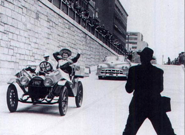
Opening day for the Dupont Circle underpass

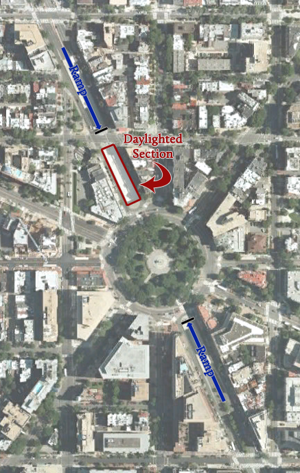
In 1950 the District opened a vehicular underpass allowing Connecticut Avenue to dive under Dupont Circle. The underpass, which still exists today, is flanked by two abandoned (and hidden) streetcar tunnels that sit behind each rusticated retaining wall. In March 2007, DDOT finished refurbishing the automobile underpass, but the city missed an excellent opportunity to restore the gashed avenue above.

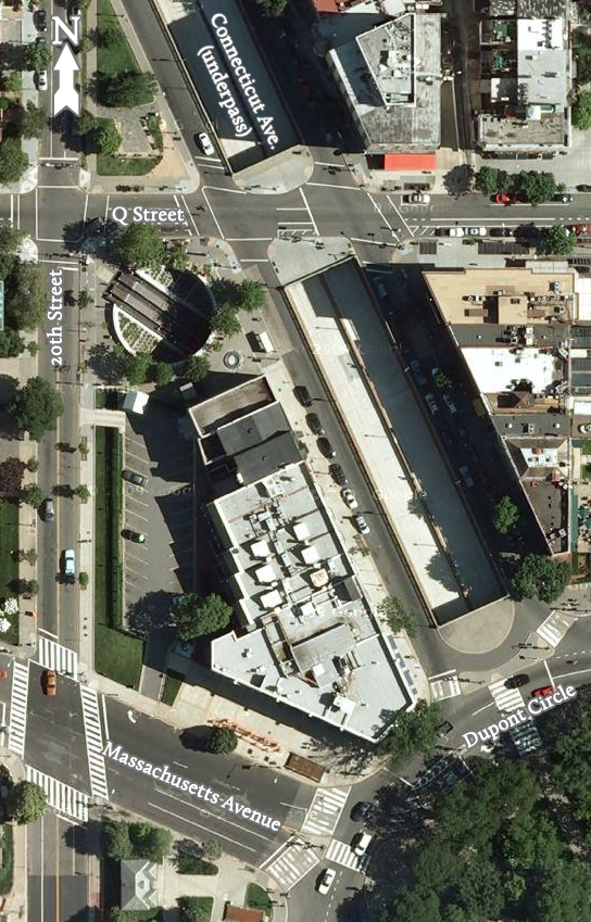
Between Dupont Circle and Q Street, the underpass is “daylighted”— exposed to the sky— needlessly monopolizing space from the block’s active street scene.

Our solution for street reclamation is simple: cap the underpass for that one block.


Toggle

Connecticut Avenue, for that one block, would become much like P Street or Nineteenth Street (on the north side) as they approach the circle. Each provides a travel lane and a parking lane in each direction— far different from the cramped and highway-like atmosphere on Connecticut Avenue.

The businesses along the block would benefit from sidewalks that will double in width as well as from easier access from the roadway, parking spaces and sidewalk on the opposite side of the avenue. The increased sidewalk space will relieve the pedestrian congestion on the sidewalks (particularly on the east side) and provide space for outdoor seating and for stores’ promotional placards. Pairs of facing street benches perpendicular to the avenue will provide more seating for shop patrons and passersby.

Furthermore, the ample, seamless space would provide another truck-accessible venue for weekend farmers’ markets or art sales and other events that a stodgy National Park Service may not permit in the circle itself.

Plans are already in motion to build over I-395 and the National Capital Planning Commission dreams of covering the E Street Expressway in Foggy Bottom east of the Kennedy Center. Compared to those proposals, this one is simpler, easier, and cheaper and would benefit more residents.

Update: We considered the idea of a medial park, but worried that it would suffer from desolation due to its separation from the active sidewalks. Though certainly better than the status quo, we suspect fewer people would want to sit in what is essentially a grassy street median. That said, it would certainly be cheaper to build— and money is no small matter in this case!

The advantage of our proposal above is that it enhances existing spaces (the sidewalks) whose heavy use warrants improvement.

Categories: Recreation, Transportation
Tags: , , , ,
-----