
Displeasure with the design of the SW/SE Freeway has led to thought about its replacement, despite the proliferation of new buildings erected close along its southern side making this more difficult and expensive.
Basic Design Flaws:
- Insufficient Capacity from 14th Street Bridges to Center Leg
- Too far northward, blocking sight lines to Jefferson Memorial and resulting in a sharper transition raddi for the connections to the Center Leg
- Is not a tunnel and hence divides area locally
- Rises above ground level east of 7th Street SW to viaduct to cross over South Capital Street and the railroad.
None of the following planning addresses these first two concerns.
Underground SW/SE Freeway Replacement
In 1993, The Washington Post published an article about the U.S. National Capital Planning Commission's "Vision" planning for the future Washington, D.C. Included within was an underground SW/SE Freeway on its existing alignment from L'Enfant Plaza to about 7th Street SE. This is presented together with the concept of an all new I-395/14th Street Bridge.
No SW/SE Freeway: Put the traffic on F Street and a new cross Potomac Tunnel to M Street SW
NCPC's 1996-97 "Extending the Legacy: Planning America's Capital for the 21st Century" keeps the 1993 plan's idea for a new I-395/14th Street Bridge, but it deletes the SW/SE Freeway, replacing it with a reconstituted F Street and Virginia Avenue, all with traffic lights, and supplemented by an all new tunnel under the Potomac River from Virginia's I-395 Shirley Highway to surface onto M Street SW.
This leaves the I-395 Center Leg (
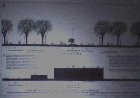
SE Freeway Tunnel
 West Portal: SE Freeway Tunnel
Passonneau & Associates
This proposal was presented at an August 2000 slide show presentation at the National Building Museum in Washington, D.C. by Joseph Passonneau.
A strictly SE Freeway is a misnomer for reasons of topography; it should actually say SW/SE Freeway Tunnel, for the eastern portion of the SW Freeway, and the western portion of the SE Freeway meet as a viaduct elevated over South Capital Street.
During his speech. Passonneau acknowledged that the project could be extended to that portion of the SW Freeway which is already below grade, such as west from 7th Street SW, either to 9th Street SW or the L'Enfant Plaza overpass at 10th Street SW.

However, Passonneau would have to be asked about the obvious lack of design work for actually depressing (lowering) this highway's grade. Take note that the configuration shown in these Passonneau & Associates renderings are implausible as a "lid" atop the existing SW/SE Freeway viaduct would be several stories high, yet is not shown in their rendering (below) of their preference for the future South Capitol Street corridor.

 This thing juxtapositions Passonneau's name with reproduction of a rendering from NCPC's "Extending the Legacy: Planning America's Capital for the 21st Century" that features the un-named South Capitol Mall: a plan he opposes. As I wrote for my original South Capitol Street web site in 2005:
Passonneau acknowledged his support for major elements of the post 1997 South Capitol related planning when questioned about them during the Q&A period of his March 21, 2005 National Building Museum lecture Washington Through Two Centuries, particularly his position against the 1997 NCPC concept for a South Capitol Street green way, and his position favoring constructing massive new real estate development projects before constructing a new tunnel along this corridor.
According to Passonneau, for South Capitol Street, "a green way would wreck the mall". Sidestepping the issue of making infrastructure projects more difficult and expensive ... [he stated] ... that "as an engineer, anything was possible". Possible sure. But how much more difficult and expensive to construct? And with what comparisons of the advantages of some real estate development occurring a few years earlier?
Passonneau has written about the Anacostia Waterfront Initiative and has produced a useful set of drawings showing the historical evolving Washington, D.C., including the National Mall's westward extension and its creation of the Reflecting Pool and the Lincoln Memorial area. He has written articles and books.
Nonetheless, Passonneau's stated stance that a South Capitol Street "green way would wreck the Mall", nor any other such opinion against the Legacy green-way/promenade/esplanade/extension of the National Mall/continuous 3rd Century Mall concept for South Capitol, does not appear in his published writings.
Passonneau's book "Washington Through Two Centuries: A History in Maps and Images" makes only scant reference to the NCPC "Legacy" plan, mainly with a single small scale plan view of the general area at page 277 with regard to its proposed railroad relocation, without even mentioning this planning substitution.
Passonneau's article "A Perspective: History of the South Capitol Street Study Area and How the Study Area Came to Exhibit its Present Conditions" discusses the Anacostia Waterfront Initiative and the focus on South Capitol Street. But it does not even mention, let alone discuss or defend the decision to replace the "Legacy" green way concept with that of yet another urban boulevard, as if the sacrifice of the relatively rare urban opportunity for a monumental green way for the sake of a plan for yet another relatively common urban surface street is too trivial of mention.
The web site of Passonneau's firm, Passonneau and Associates makes no mention of his/their involvement with South Capitol Street related planning. http://www.Passonneau.com
Much like the Committee of 100 of which he is a member, Joseph Passonneau appears to have nothing but words of praise for the Anacostia Waterfront Initiative, D.C. Mayor Williams and Office of Planning Director Altman.

Un-reported in any newspaper account of Mr. Passonneau's August 2000 National Building Museaum presentation, were his comments that he personally opposed any SW/SE Freeway, that "if he were King of the World" there would be no SW/SE Freeway tunnel at all, with the traffic placed on the surface street grid or perhaps the Capital Beltway miles away.
Perhaps this is why he fails to provide a workable plan for a SW/SE Freeway Tunnel?
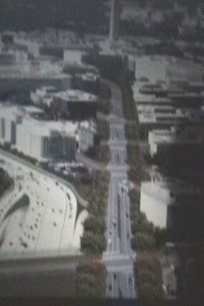
Cover I-395 by the Jefferson Memorial
Arthur Cotton Moore
This is the latest proposal I have seen for doing something to the SW Freeway approach roadways alongside the Jefferson Memorial.
It places a lid over the I-395 roadways immediately to the south of the Jefferson Memorial.
All of the planning illustrations misrepresent the space between this memorial and these roadways, to create the impression of a far gentler "slope" then the actual steep wall that this would create.
This proposal was presented at a December 2005 meeting.
SE Freeway Tunnel: Un-named
This appears in the Middle Anacostia Transportation Study
It applies to the segment to the east of the 11th Street Bridges.
Due to the topography it present the least expensive underground highway segment in Washington D.C.
It could be applied to the not yet built continuation beyond Barney Circle, as I have already suggested.
However this idea appears on this study only in the illustrative cross sections for how to cover this SE Freeway segment with a boulevard, with no text acknowledging the obvious practicality of reserving the existing roadways as a covered highway.
Making it more difficult
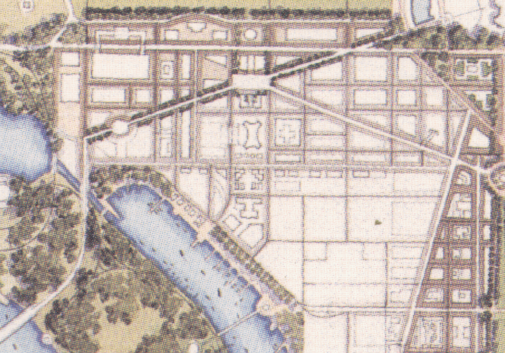
 "Capital Square" site at lower left, before its construction
with USDHUD at upper left and USDOT at upper right
Image produced by National Capital Planning Commission for the Washington Geographic Information System. Distributed by VARGIS LLC of Herndon, VA.
This makes it more difficult and expensive to construct new retaining wall for tunnel roof (as the existing walls would not be likely to be so designed), hence keeping the existing SW Freeway in a configuration that divides DC SW - hence contrary to long term NCPC planning for the removal of the mass of elevated highways and railways that now cross over South Capital Street.
This also makes it more difficult and expensive to improve safety and decrease congestion and pollution with mitigating the SW Freeway bottleneck southwards and westerly of the Center Leg, hence more likely remaining a traffic bottleneck with ripple effects well into Virginia.
And to think that this planning malfeasance occurs within site of the headquarters of the US Department of Housing and Urban Development and the US Department of Transportation!


No comments:
Post a Comment