Friday, December 16, 2011

Ribbon Cutting


View more videos at: http://nbcwashington.com.


Only a ribbon cutting- actual opening is in a few days, and from I-295 northbound, with the other ramps completed later.

Thursday, December 15, 2011

Tomorrow's [Scheduled] Opening- 11th Street I-695 Bridges


Friday, December 16, 2011
9:00 am - 9:45 am Refreshments
DC Department of Housing and Community Development
1800 Martin Luther King, Jr. Avenue, SE
Washington, DC

10:00 am, Ribbon Cutting Ceremony

On-site parking will not be made available to the general public on the new bridges. Bus transportation to and from the event will be provided between 9:30 and 10 am from the DHCD Office.


For more information on this event, please call 202.484.2330. To learn more about the 11th Street Bridge Project, visit ddot.dc.gov/11thStreetBridge.

On Top NOT


Emily Badger writes:

http://www.theatlanticcities.com/commute/2011/12/imagining-city-without-its-public-transportation/690/

"Today, where that behemoth of an interchange would have sat right on top of Mount Vernon Square, there is instead a metro line below ground, and a mixed-use grocery store and apartment complex above."

Actually no.

The freeway was to be a TUNNEL, with any of the exposed roadways BELOW GROUND-LEVEL, and accommodating new real estate development.


As Scott M. Kozel correctly describes it:

http://www.roadstothefuture.com/DC_Interstate_Fwy.html

The I-66 portion of the North Leg of the Inner Loop would have extended from the present I-66 terminus near the Watergate Apartments at K Street NW, extending as the North Leg under K Street NW in a tunnel, and emerging east of Mount Vernon Square and junctioning with I-95 about a mile north of the U.S. Capitol Building.

The I-66 portion of the North Leg would have had 6 lanes. The I-66 K Street Tunnel was the solution to the original I-66 alignment that would have run east-west through urban neighborhoods alongside Florida Avenue NW, and between T and U Streets NW about a half mile north of K Street NW. If the K Street Tunnel had been built, it would have been a cut and cover design, about 1.5 miles long, buried out of sight under the straight 147-foot wide avenue, and passing under Mount Vernon Square, and it would have run from near Watergate almost to today's New York Ave./I-395 junction.

The underscores how writers must check facts rather then simply relying upon entities as WMATA, or 'mainstream' media such as The Washington Post, which can't even be honest about the route for I-95, let alone the I-66 K Street Tunnel.

I-66 K Street Tunnel
http://wwwtripwithinthebeltway.blogspot.com/2007/03/i-66-north-leg-west-k-street-tunnel.html

I-395 (I-95) Extension
http://wwwtripwithinthebeltway.blogspot.com/2009/01/i-395-extension.html

Wednesday, December 14, 2011

WMATA Pushing False Dichotomy of Them OR Freeways

misleads by failing to acknowledge reduced footprint of freeway tunnels, particularly in the context of accommodating new development, and that transit and freeways were planned together

November 2011 WMATA report
http://planitmetro.com/wp-content/uploads/2011/12/WMATA-Regional-Benefits-of-Transit-11.28.2011.pdf

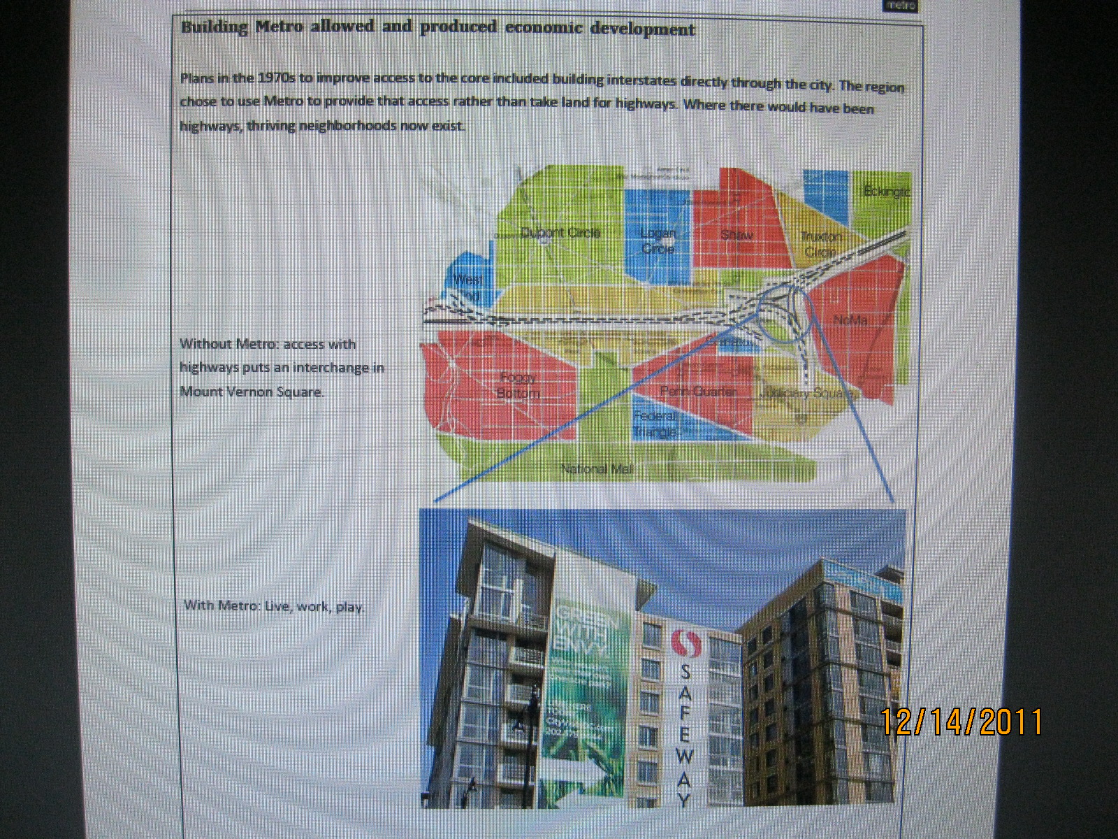
Building Metro allowed and produced economic development

Plans in the 1970s to improve access to the core included building interstates directly through the city. The region chose to use Metro to provide that access rather than take land for highways. Where there would have been highways, thriving neighborhoods now exist.

Without Metro: access with highways puts an interchange in Mount Vernon Square.
Actually beneath the streets and with new development
WMATA would have us forget that the I-66 K Street Tunnel planning came WITH transit planning
With Metro: Live, work, play.
Actually with Metro AND the freeways
In particular, much of the Mount Vernon Square neighborhood would have been lost to a large interchange. At the time, the interchange would have displaced 845 dwelling units and 97 commercial and industrial firms employing 980 people.
Actually not true, the interchange was to be underground, and beneath existing right of way, with some additional land acquisition which would have new development like that now being built. The displacement was quantitatively perhaps none (given the replacement housing within the new development atop), with 148 existing dwellings displaced for the Mt Vernon to 4th Street segment (the 845 figure including the extension to 1st Street NE, including the easternmost block of townhouses demolished about 10 years ago).
As the area has developed, north of New York Avenue, we now have a neighborhood of row houses, small apartment buildings, and churches. The sidewalks are brick and shadowed by tall trees. On New York Avenue, we have several restaurants, bars, and a car mechanic.
The City Vista block (east of 5th, between L and M) would have been parking above the freeway. Thanks to Metro, we instead have a vibrant development: apartments, condominiums, a large Safeway, a mobile phone store, a bank, a hardware store, a variety of restaurants (some with outdoor seating), a gym, and a Starbucks. A farmer's market has opened up a block away. It is a half to three-quarters of a mile to three subway stations, and only a mile to a fourth: Union Station where you can also connect to the Amtrak lines going all up the east coast.
In short, this is a great neighborhood with lots of variety and everything its residents need. Had the region chosen the freeway instead of Metro, we would have lost this neighborhood and its contributions to employment, taxes,and quality of life [sic- see below].

Sources: Map and description of displacement adapted from “District of Columbia Interstate System 1971,” November 1971, DeLeuw, Cather Associates and Harry Weese & Associates, Ltd. City Vista photo: Sean Robertson.

Forgotten is that the rail transit and freeway systems had been designed together.


http://mysite.verizon.net/cambronj/wmata/m80-52.jpg

WMATA Subway Plans Indicate the I-66 K Street Tunnel

1971 DeLeuw Cather Weese study report 
showing intact Mt Vernon Square with I-66 in tunnel beneath


1971 DeLeuw Cather Weese study report 
showing intact Mt Vernon Square with I-66 in tunnel beneath, plus uncovered below-ground interchange to the east with parking lot that would be compatible with a replacement by a building akin to as done above the Center Leg at K Street

Center Leg at K Street- 
WMATA misrepresents the planning as if buildings were not or could not be placed atop freeway area.

http://wwwtripwithinthebeltway.blogspot.com/2007/03/i-66-north-leg-west-k-street-tunnel.html


1971 Freeway Planning Replacement Development


New Development OK with highway traffic on street rather than in tunnel?!
 
WMATA appears to be echoing an inacurate description of the freeway planning seen elsewhere by those acting as if oblivious to the highway history web sites as A Trip Within the Beltway and Scott Kozel's D.C. page at Roads to the Future.


Sunday, December 04, 2011

CSX Virginia Avenue Tunnel- Cross Sections Published

Concept 5 preserves the most space alongside the SE Freeway, thus best facilitating the freeway's lowering/tunnelization, ESPECIALLY if it shifted the new northern tunnel closer to the new southern tunnel, rather then using the existing tunnel's centerline. Concept 5 avoids the waste of filling in a new excavation via making the new cut into a new tunnel, and furthermore preserves part of the existing tunnel's excavation for the outboard portion of the future underground SE Freeway.


The report also includes options of a temporary cut to the north of the existing tunnel, even though that provides less space for lowering-covering the freeway, but may run into issues with the existing elevated freeway's underground piling supports. Concept 2 is essentially CSX's traditional preferred plan, with Concept 5 a recent addition.


Virginia Avenue Tunnel Study
http://www.virginiaavenuetunnel.com/media/uploads/downloads/VAT_Public_Alternatives_Meeting_Presentation_Combined_FINAL_1.pdf

More from JD
http://www.jdland.com/dc/index.cfm/3586/Virginia-Avenue-Tunnel-Project-Concept-Designs-Unveiled/

Wednesday, November 02, 2011

Takoma, D.C. Death Trap Residential Development

"The zoning permits wood framed construction, reducing costs"


Post 2001 Washington, D.C. 'planning' for death trap residences of wood framed construction 'reducing costs' within rail-car derailment footprint, in total disregard of safety to chock this important transportation corridor.


Such de-railments along this corridor in 1976 and 1996 avoided mass loss of life because the dwellings were set back from the railroad, either via Blair Avenue, or a parking lot.

And to consider that these death trap developments, starting with Elevation 314 and Cedar crossing occurred after 911 with the lip service given towards transportation evacuation routes.

That would logically include this corridor -- the sole main north-south transportation corridor for what is said to be the Nation's Capital -- for the un-built and deceitfully de-maped North Central Freeway proposed by U.S. President John F. Kennedy, November 1, 1962, only to be botched by its initial engineering study - deviating from JFK's prescription for the freeway to tightly follow this existing railway - initiated at about the time of his assassination some 8 days after he personally inaugurated this freeway's Baltimore-Deleware segment.

More potential death trap 'transit oriented' development favored by WMATA:

http://wwwtripwithinthebeltway.blogspot.com/2011/08/forgotten-elephant-building-too-damn.html


Tuesday, October 18, 2011

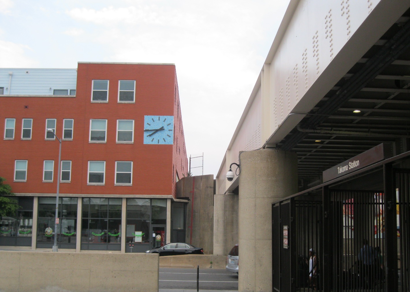
Takoma D.C. Travesty- Cram 'em in

Another example of a planning malfeasance- just inside Washington D.C.

This cramming in of residential units next to RR is insane- especially when it is built within the footprint of a derailment AND at a lower elevation, such as the dangerously close "Elevation 314".

I say it can all be demolished as hazardous- which it is not only to the new dwellers, but to local and larger community and societal interests and needs, particularly for a much needed super-project to give the area its missing and needed comprehensive transportation, linear parkland, and bringing that creek back to the surface.

Douglas Willinger
A Trip Within The Beltway
Build the Grand Arc
---

Proposed Spring Place Apartments – October 19 & 24 Meetings & Hearings

Developers Donald Tucker and Bruce Levin propose building two five-story buildings, a total of 140 apartments, on Spring Place, NW (along the RR Tracks and behind the Gables Apartments on Blair Road, NW). Access would be at Blair and Chestnut.

Some residents have asked for changes and more time to work on the proposal. I hope the developers will agree. They are making revisions. As it now stands, here are the project details and the timing.

Details
* Buildings will be approximately 45 feet tall
* Phase I – 60 affordable rental units, funded by several DC government programs, 11 parking spaces
* Phase II – 80 market rate rental units, 31 parking spaces (parking lot backs up to Chestnut Street homes)
* Materials are Hardie Plank (a concrete product) and pressed concrete block

The developers are requesting that a short street/alley be closed and are also asking for a reduction to the parking requirements, which must be approved by the Board of Zoning Adjustment (BZA). The developers must provide a traffic study, which they estimate will be available in November. It is possible that no new traffic controls at Chestnut and Blair will be provided and that none will be required.

1. Wednesday, October 19 - Developers meet at the Landis Building, 7059 Blair Road, NW from 6:30 -8:30 pm to present revised plans. Contact the developers (info below) for a site tour between 4:30 and 6:30 pm.

2. Key Vote, Public Views Solicited - October 24, 7 pm, Advisory Neighborhood Commission 4B - 4th District Community Room, 6001 Ga. Ave., NW

ANC 4B will vote on its recommendation to the DC Historic Preservation Review Board (HPRB) . The proposal is in the Takoma Historic District and HPRB must review and approve the design for its appropriateness, size, materials, and impact on the historic district, among other issues. Traffic and environmental issues are not part of HPRB’s review.

3. Deciding Vote, Public Testimony Solicited - November 17 (Time TBA, but during the day)
441 4th St., NW, Room 220 South (next to Judiciary Square Metro – Red Line)
HPRB will decide whether to approve the design, reject it, make changes, or ask staff to make changes
4. February?? 2012 - Board of Zoning Adjustment Public Hearing – Traffic Issues - TBA
To see the proposal (no revised drawings available yet), go to my web page, ANCSaraGreen.org
Please share your comments with me.

--- Sara Green, ANCSaraGreen@yahoo.com (202) 829-8802

Developer Contact Information:
Bruce Levin – 301-364-4510 blevin@keystarrealestate.com
Donald Tucker – 301-654-6670 don@ecohousing.net


Sara Green, ANC 4B01
See my website: http://ANCSaraGreen.org