Monday, February 01, 2010

Cap Connecticut Avenue NW


An excellent idea that also should be applied to the open depressed segments of North Capitol Street at Rhode Island and New York Avenues

Found at Greater, Greater, Washington:
http://greatergreaterwashington.org/post.cgi?id=4764
From Left For LeDroit:

http://leftforledroit.com/2010/01/putting-a-lid-on-it/

January 31, 2010

Putting A Lid On It

Opening day for the Dupont Circle underpass

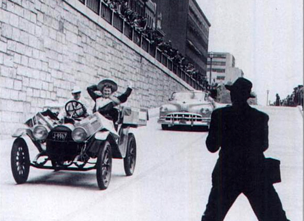
In 1950 the District opened a vehicular underpass allowing Connecticut Avenue to dive under Dupont Circle. The underpass, which still exists today, is flanked by two abandoned (and hidden) streetcar tunnels that sit behind each rusticated retaining wall. In March 2007, DDOT finished refurbishing the automobile underpass, but the city missed an excellent opportunity to restore the gashed avenue above.

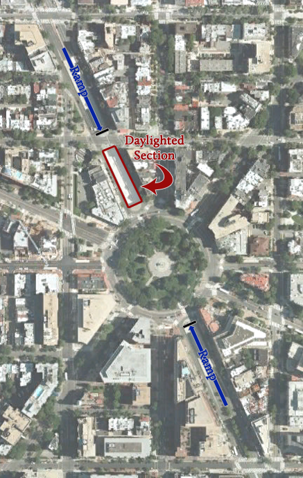
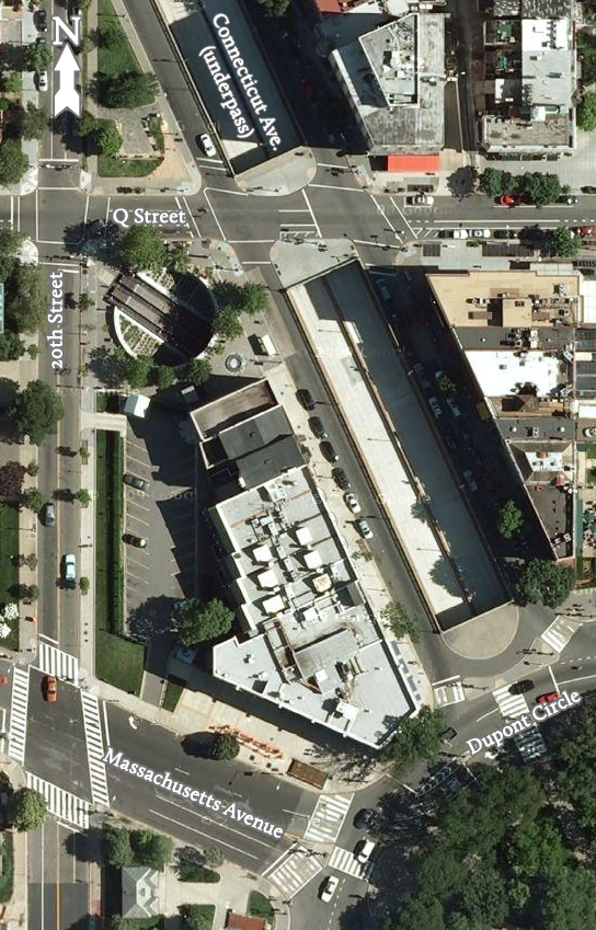
Between Dupont Circle and Q Street, the underpass is “daylighted”— exposed to the sky— needlessly monopolizing space from the block’s active street scene.

Our solution for street reclamation is simple: cap the underpass for that one block.


Toggle

Connecticut Avenue, for that one block, would become much like P Street or Nineteenth Street (on the north side) as they approach the circle. Each provides a travel lane and a parking lane in each direction— far different from the cramped and highway-like atmosphere on Connecticut Avenue.

The businesses along the block would benefit from sidewalks that will double in width as well as from easier access from the roadway, parking spaces and sidewalk on the opposite side of the avenue. The increased sidewalk space will relieve the pedestrian congestion on the sidewalks (particularly on the east side) and provide space for outdoor seating and for stores’ promotional placards. Pairs of facing street benches perpendicular to the avenue will provide more seating for shop patrons and passersby.

Furthermore, the ample, seamless space would provide another truck-accessible venue for weekend farmers’ markets or art sales and other events that a stodgy National Park Service may not permit in the circle itself.

Plans are already in motion to build over I-395 and the National Capital Planning Commission dreams of covering the E Street Expressway in Foggy Bottom east of the Kennedy Center. Compared to those proposals, this one is simpler, easier, and cheaper and would benefit more residents.

Update: We considered the idea of a medial park, but worried that it would suffer from desolation due to its separation from the active sidewalks. Though certainly better than the status quo, we suspect fewer people would want to sit in what is essentially a grassy street median. That said, it would certainly be cheaper to build— and money is no small matter in this case!

The advantage of our proposal above is that it enhances existing spaces (the sidewalks) whose heavy use warrants improvement.

Categories: Recreation, Transportation
Tags: , , , ,
-----

Friday, January 15, 2010

11th Street Bridges Project: How We Got There

Cancelling All The Other D.C. Freeways:
the Barney Circle Project and the earlier East Leg


11 Street Bridges (new replacement- construction started late 2009)

This area’s previous project was the Barney Circle Connector, proposed in 1982-83 to essentially continue the I-695 SE Freeway to a split to a parkway not allowing commercial traffic to RFK East Capital Street, and a straight ahead continuation of the mainline freeway upon a new bridge crossing the Anacostia River to the existing 295 freeway to and from the east. Initially each of these was to have 2 lanes per direction, feeding into the 4 lane per direction SE Freeway; however this was soon downsized with the parkway having a single lane per direction.

Illustration: Barney Circle Connector

It succumbed to a law suit alleging environmental grounds, and had its political death with a 1996 D.C. City Council rejection of its initial construction contract. Although promoted by the D.C. government under a Mayor Marion Barry who had risen to political prominence with the anti-freeway organization ECTC – the Emergency Committee on the Transportation Crisis – the project towards the end was not supported by U.S. NCPC.

Illustrations: BCC

The preceding plan was the East Leg of the Inner Loop as routed towards RFK Stadium.

Illustrations: East Leg 1967

The original plan for the East Leg along 11th Street.

Illustrations: East Leg 1955

Illustration: 1961 East Leg ideas

Yes, the 11th Street Bridges were actually initially meant as a link in a longer north-south route.

Illustration: 1959 Mass Transportation Plan

As per both the 1959 Mass Transportation Plan, and the initial I-95 Northeastern Freeway engineering study report released in 1960, this 11th Street corridor would have linked directly with I-95.

The East Leg was to be I-295, with I-95 routed via the north south Center Leg to the SW Freeway.

Under all of these plans with an East Leg, the traffic burden was to be spread with north-south traffic upon a north-south route within northern Washington, D.C. While the 1959 Mass Transportation Plan had three separate northern radial freeways, the November 1, 1962 Kennedy Administration report proposed a single 2 into 1 “Y” route B&O railroad aligned North Central Freeway signed as I-70S to the north of the point of its interception via the Fort Drive-Northwest Branch route I-95 Northeastern Freeway.


JFK 1962 Plan

1963-1964 Study

A sensible idea for its central location and its existence as the sole north-south railroad industrial corridor, minimizing residential displacement, the B&O Route North Central Freeway would be politically subverted by its initial 1963-64 engineering studies extreme deviation. That study had an upwards of 37 route options either nowhere near the railroad, or partially paralleling it with serious deviations in Takoma Park, Maryland, and in Brookland, NE D.C.; that would understandably inflame opposition, while the subsequent supplementary 1966 study’s more true to the 1962 JFK version, would be sabotaged by various officials refusing to commit to it; they would argue in favor of instead constructing the infamous 1964 version as late as 1968, long enough to stoke the opposition to reverse the support of the D.C. City Council and the U.S. NCPC for the B&O Route North Central Freeway over the 69 houses (reduced by a design revision in 1970 to 34) for its I-95 segment (while approving I-66, Route 50 and I-295 links with segments respectively displacing 148, 600+ and 172 dwellings as per the 1971 plans).

Illustrations: 1971 plans

These plans would have provided replacement housing, perhaps with even greater numbers of dwellings as the size of the buildings shown suggest.
These northern segments of Washington, D.C.’s planned Inner Loop Freeway system, though substantially redesigned to minimize and mitigate impacts, would be ‘de-mapped’ as per the reasons stated byPeter S. Craig:

Quote 1973-76

This period of de-mapping, leading to a cir 1976 decision to rename inside the Beltway I-95 as I-395 with its extension alongside New York Avenue to Maryland Route 50 cancelled a few years later, culminating in I-395’s current northern truncation at New York Avenue and 4th Street with the 1986 opening of I-395’s northernmost segment with the tunnel segment between Massachusetts Avenue and K Street.

In 1996, at about the time that the Barney Circle Connector Project was under serious political attack, the D.C. Office of the Mayor (Marion Barry) released its proposal for an I-395 extension via a tunnel directly beneath New York Avenue- an idea that would displace no buildings and, upon a single level, allow as many as 7 lanes with shoulders, yet nonetheless be offered only with 4, and have a relatively tight transition radii – something to think about for a curved tunnel – essentially wrapping behind the Bibleway Church complex. The 1996 report includes two options regarding its length, a short tunnel option with its eastern portal at Florida Avenue, and a long option with its eastern portal at 6th Street NE. A 1998 revision would extend this long tunnel to Montana Avenue.


Yet later planning would subsequently go in reverse, with D.C. government planning suggesting a tunnel even shorter then the 1996 short option, with the mainline crossing over Florida Avenue, and with USNCPC even endorsing a tunnel shorter then that already in use today by closing I-395’s northernmost tunnel segment hereby truncating I-395 at Massachusetts Avenue.

Quote

Sunday, January 03, 2010

11th Street Bridges 11th Hour Design Revision

Anacostia to get new 'sky-way'

Skanska/Facchina

This a part of the 11th hour redesign of the 11th Street Bridge project that changes the configuration of southbound DC 295 to pass as an elevated viaduct.

This is part of a plan that was reported favorably by Greater Greater Washington/ David Alpert.

Athough elevated waterfront urban freeways are generally decried, apparantly no one within the 'new urbanist' community felt that the area to the southeast of the Anacostia was worthy enough to even mention this aspect of the design change.

Reportedly, construction on this project started on December 29, 2009.

Where are the protests?

And what is the position of such organizations as the 'Committee of 100 on the Federal City'?

Tuesday, December 29, 2009

Peter S. Craig: An Editorial Reply

The Washington Post Does Not Get It-
subverting transportation based upon lies
(excerpts)

http://www.washingtonpost.com/wp-dyn/content/article/2009/12/20/AR2009122002242.html

For more than two decades, Mr. Craig battled business interests, developers and members of Congress who wanted to build a bridge over the Potomac River to carry Interstate 66 into Georgetown and seven multilane highways, which would have destroyed more than 200,000 housing units, many in historically black sections of the city.

http://www.washingtonpost.com/wp-dyn/content/article/2009/12/22/AR2009122203176.html?sub=AR

CHRISTOPHER WREN, the great 17th-century English architect, whose many works dominated the London scene, had as his epitaph, "If you seek his memorial, look about you." Similar words might be fitting for Peter S. Craig, who died Nov. 26 at the age of 81, only in his case it would be what you didn't see that would mark his significance. ... [such as] a long-planned North-Central Freeway running through much of the eastern part of the city and over places where thousands of people live. In all, Mr. Craig and his allies succeeded in blocking about three-quarters of the interstate highway system once planned for the District....

There are still some who argue that the city made a major mistake when it blocked those highways. Most Washingtonians, we think, when they look about the city, with all its beauty and its history as community and national capital, would say otherwise.
The Washington Post reports he was a railroad attorney at Covington & Burling- something to think about concerning Washington, D.C.'s beauty, given the Posts' own expressed cluelessness convenient for diverting attention from the blight of to Washington, D.C. NE in the areas behind Union Station, with beauty in from, but ugliness behind.

http://www.washingtonpost.com/wp-dyn/content/article/2009/12/20/AR2009122002242.html

Mr. Craig was working for the powerful Covington and Burling law firm in the 1950s, specializing in transportation regulation matters, when he became aware of plans to build a freeway from the Georgetown waterfront up Glover-Archbold Park and out Wisconsin Avenue into Bethesda, where it would have joined what is now Interstate 270.

Craig was also long involved with the “Committee of 100 on the federal City”- a private organization founded in 1923 by Frederic A. Delano, uncle to FDR and brother in law to Covington & Burling co-founder, railroad industry attorney Edward Burling. OK, so this law firm has a long history representing the railroad industry.

He got involved in 1959 when planning was going to bring a highwa, the I-70S Northwest Freeway, near his residence in Cleveland Park.

Why- the logic of the Wisconsin Avenue corridor as the most commercialized corridor spaced roughly midway between the Potomac River and the B&O corridor, & the barring of a highway allowing trucks via Glover-Archbold Park, leading to a search of alternatives, with a brief consideration of a Cathedral Heights Tunnel, before a 1958-59 route via a split at the top of Glover-Archbold for a parkway not allowing trucks, with an I-70S continuation via a separate route known as the Cross Park Freeway starting as a tunnel just north of Fannie Mae and the northern edge of the Sidwell Friends School property to parallel Tilden Street, skirting the northern edge of Cleveland Park and entering another tunnel crossing east of Connecticut Avenue and emerging to cross Rock Creek Park via a highway arc bridge before continuing as an open depressed freeway through Mt Pleasant, starting at , crossing 16th Street before turning south to parallel 14th Street continuing to an interchange with the open trench I-66 along U Street.

This highway would have displaced 74 dwellings along the Wisconsin Avenue corridor, about 8 to the east in or near Cleveland Park, and 100s if not 1000s to the east of Rock Creek Park. Whereas the 1959 version added the two tunnel segments in the Sidwell Friends/Cleveland Park area in addition to the Tenley Circle underpass, it would fail to even consider tunnel segments anywhere to the east of Rock Creek Park, limiting any options to merely depressed with sloped embankments or depressed with vertical retaining walls. From a preservationist standpoint, the most sensible opposition was that to the east of Rock Creek Park, with the least sensible being Bethesda, Maryland which ended up tearing out and replacing most of its downtown business district anyway via WMATA Red Line subway induced denser development that could and should have included an underground highway.

Its effective cancellation via the 1960 – Act mandating a moratorium on free planning for DC NW west of Rock Creek Park – via political pressure from the area with the fewest impacts testifies to the dominance of political affluence.

This did not mean that Peter S. Craig necessarily opposed other freeways within Washington, D.C.

During the early 1960s, Craig and the "Committee of 100" publically supported the concept of a “Y” route B&O railroad I-70S North Central Freeway featured by the November 1, 1962 Kennedy Administration White House report "Recommendations for Transportation in the National Capital Region; A Report to the President for transmittal to Congress by the National Capital Transportation Agency". Regarding that multi-model concept, the report stated:
http://wwwtripwithinthebeltway.blogspot.com/2006/12/1962-national-capital-transportation.html

"avoiding the substantial relocation of persons, loss of taxable property and disruption of neighborhoods that would result from constrction of the Northeast, North Central and Northwest Freeways proposed in the 1959 plan. Further savings are realized by placing the rapid transit lines to Silver Spring and Queen's Chapel in this same railroad corridor."
The B&O corridor makes perfect sense not only as a railroad corridor providing a band of lightly developed industrial property, but also with its placement roughly midway between the Potomac River and the eastern portion of the I-495 Capital Beltway in Maryland.

It was consistent with a philosophy embodied in proposals made via Craig cir. 1962. Not for not buildings the highways. But rather for building highways instead more via existing corridors/right of ways, occasionally coupled with the idea of some short segments of these highways as tunnel.

I found two such proposals in perusing some of his papers and those of the Committee of 100 on the Federal City that are graciously made publicly available at the GW University Gelman Library Special Collections: constructing inside the Beltway Virginia I-66, not via the official route, but rather via a reconstructed fully grade separated Route 50 (already a major 4 – 6 lane artery generally flanked by service roads); and constructing the downtown D.C. north-south I-95 Center Leg (known today as the I-395 3rd Street Tunnel), not via the official routing via a swath cut via clearing a swath of buildings between 2nd and 3rd Streets, but instead as a pair of cut and cover tunnels respectively beneath 2nd and 3rd Streets. Obviously, neither idea was adopted, and I did not find any evidence of any official consideration.

Craig at times expressed favor for this concept for the Georgetown waterfront via removing and replacing the elevated Whitehurst Freeway with a tunnel within the existing right of way; in 1968 the Committee of 100 briefly proposed extending that tunnel beneath the Potomac – a Three Sisters Tunnel – to Virginia; they soon abandoned that idea due to the costs of drilling a sufficiently long tunnel to accommodate a sufficiently gentle grade transition for trucks, with Craig’s idea for a shorter tunnel only along the Georgetown waterfront being coupled with the idea of it being sufficiently reduced in capacity not to preserve anything but rather so that it would be useful to fewer.

Such was followed by Elizabeth Rowe with the I-66 K Street Tunnel proposal

The flip- said to have been guilted by Abbott. Since he strictly opposed freeways in NW, he would have to do the same elsewhere.

Its absurdity- was in response to a response to a bastardized program - came in the name of stopping white mans roads through black mans homes. The idea of opposing “white mans roads through black mans houses” could make sense: as such meant a road that would go through a less affluent area rather then a more affluent area, or through the latter without the extra mitigation of tunnels seen in more affluent areas. Such example of this include the 1955 Inner Loop design for I-66 different treatments west and east of New Jersey Avenue- to the west as trench, to the east as an elevated berm, the 1959 NW Freeway that Craig stopped which would have taken fewer then 100 from the Maryland line to Rock Creek Park, but considerably more to the east, with tunnels only for areas to the west, and of course the 1964 NCF report’s options. [This led to some intelligent things as the I-66 K Street Tunnel proposal via Elizabeth Rowe in 1965-66. ] But opposing such was hardly was synonymous as simply stopping freeways as that would simply kick the can elsewhere- a main consistency of the shifting polices of Craig and the Committee of 100.

He could have called for greater right of way efficiency and tunnelization for the highways within the western part of the inner loop.

He could also have done that with the NW Freeway proposing a different tunnel for its southern end. But AFAIK he did not.

He could have called for greater right of way efficiency and tunnelization for the highways within the eastern part of the east loop. Oddly to me, despite all of his opposition to say the Glover-Archibold Parkway I saw no indication he opposed the Northwest Branch Park routing for the I-95 Northeastern Freeway before he opposed the freeway outright, failing to apply the concept of reusing existing corridors in this instance with that giant PEPCO power line right of way to New Hampshire Avenue that would require only 13 retail strip properties, and clusters of 24 and 5 houses flanking a short jaunt through the open field of the Masonic and Eastern Star Retirement Home at 6000 New Hampshire Avenue NE to meet the B&O Route. Craig could have further applied such concepts to the B&O NCF. But AFAIK he did not.

Instead he took a course that would effectively be a “white mans road through black mans homes” – or area, depending upon if it displaced dwellings along the railroad corridor in Anacostia SE – via the Anacostia Freeway. If it had not displaced any homes, it would have simply been placing the traffic disproportionately through such areas by stopping both the NW Freeway and the NCF-NEF.

Craig's allies, the Committee of 100 did this with a 1968 proposal for re-routing inside the Beltway I-95 along a longer portion of the NWBP and Virginia 4 Mile Run.

It was SE and in Virginia that Craig's allied "Committee of 100" would soon promote receiving even more of the burden, with their work to cancel the B&O Route North Central Freeway, supplemented by their 1968 proposal for a longer routing of inside the Beltway I-95 via Northwest Branch Park bringing it directly to the Anacostia Freeway, with the Baltimore-Washington Parkway reconfigured to come directly into the I-295 East Leg of the Inner Loop, and with I-95 continuing via the Anacostia Freeway extended somehow across the Potomac River to Virginia and continue via the 4 Mile Run corridor to the existing I-95 Shirley Highway.

Illustration: 1968 proposal, Brookland houses, ECTC protests

All to avoid 69 post WW1 townhouses targeted by the 1966 plans at the western edge of Brookland from the west side of 10th Street NE to the railroad’s eastern side, all to the south of Monroe Street that crosses the railroad just to the south of Catholic University of America located immediately to the railroad’s west side along Brookland Avenue. These 69 dwellings, a fraction of that targeted by the 1964 and 1960 proposals which would have decimated Turkey Thicket and Brooks Mansion which the 1966 and later plans spared, were colorfully protested by ECTC- the Emergency Committee on the Transportation Crisis, even after this number of 69 was reduced to 34 by a 1970 D.C. Department of Public Works design modification realigning the freeway closer to the railroad, and/or substituting its eastern side sloped embankment with a vertical retaining wall. Internet writer Mark Bentley, in misc.transport.road noted:

http://wwwtripwithinthebeltway.blogspot.com/2007/02/review-of-1998-panel-freeways-in.html

Mr. Korr was followed by our own Douglas Willinger, who, in rather agonizing detail, laid out some of the literally dozens of alignments that were at one time or another planned for DC. The most horrifying was of course the Rock Creek Park alignment. By 1971, as we know, the alignment was almost entirely along mostly abandoned industrial corridors, and had gone from taking 4,500 homes to a whopping 69. But of course those 69 homes were worth saving, as they are today worth 1,017,391,304 each (225,000 commuters at $10/hr for 30 years spending an extra half hour on the beltway). The bargain of the century, in fact, in that you can buy one today (well, one that's remaining, several have been torn down anyway) for about $75,000. Not a bad return!

With only 34 rather the 69 that $1,017, 391, 304 figure is roughly doubled.

With only 11-14, that doubled figure is roughly tripled.

I did not find any discussion on how a longer route via a longer route along a more sensitive watershed area of Northwest Branch Park was necessarily more worthy then a more direct route via the existing railroad-industrial corridor, nor consideration of tunnel segments. Nor did I find anywhere near the amount of consideration that lead to the B&O NCF route concept in 1962, regarding whatever they gave to the Craig-Committee of 100 flip, against the B&O North Central Freeway by 1966 reportedly in response to Sam Abbott shaming him into eventually opposing any proposed freeway, never-mind the actual designs and consequences, all based upon the B&O North Central Freeway’s bastardization which lead to the rush of popular opposition.

Indeed, the idea of “white mans roads through black mans homes” a great deal of sense for a NCF that would displace 720/590 with options going as high as 2770/--- on the heels of cancelling a NWF that would have taken fewer then 100 dwellings to the west of Rock Creek Park, as opposed to simply the 1962 Kennedy Administration B&O Route NCF that as per the 1966 supplementary study would have displaced 372 within DC, of these 69 for the I-95 segment. That slogan made far less sense against the B&O concept due to its central location and status as an industrial corridor providing a swath of lightly developed properties.

Perhaps this was because such a mangling, such as that seen in 1964, was required to stoke the opposition, hence the political need to use the righteous opposition to the 1964 plan to inflame the passions against any NCF, and for purely selfish reasons.

Such appears to be the case, even after the release of the 1966 plan with officials waffling on the earlier plan through 1967 and as late as 1968. From a June 1, 1967 letter from Takoma Park, Maryland resident Duncan Wall:

The re-studied proposal also tacitly admitted that the route first proposed was needlessly, even carelessly if not ruthlessly, destructive of our communities. The new version hugged both sides of the existing Baltimore and Ohio railway, thus avoiding a new swath of destruction to divide our communities and sharply reducing the number of homes to be taken.

The reduced, re-routed proposal was made public last year with endorsement of D.C. And Maryland highway authorities. The D.C. Portion was forced through the National Capital Planning Commission by votes of representatives of the D.C. Highway Department and of the U.S. Bureau of Public Roads. From this we concluded, reasonably enough, that the highway authorities of the two jurisdiction cons (Maryland and D.C.) had reached a firm understanding with the Bureau of Public Roads.

Many of us were therefore astonished and aroused to preparations for renewed protests when Washington newspapers recently reported that the Bureau has acted to open it all up again. We have not found the Bureau forthcoming with candid information, but the press articles intimate an intention to force Maryland to accept modifications of route or design ostensibly "cheaper."

The result is that the whole controversy, which had been somewhat quiescent, is beginning to agitate the communities again. I can assure you this is so, for although I recently resigned chairmanship of the Metropolitan Citizens Council for Rapid Transit and write this simply as an individual citizen who wishes your administration well, I do remain in close touch with neighborhood sentiment on transportation-related issues.

As Governor of our State, you are in position better than we as private citizens to require straightforward answers from the Bureau of Public Roads.

You can also insure that the Maryland State Roads Commission refuses to go along with divisive proposals which these communities will regard as cause for new protests.
Such was sufficient time to stoke the opposition to get the DC City Council and the U.S. NCPC to flip their support to opposition.

Quote USNCPC 1968

Such fit with the pursued legal strategy, of declaring the freeway illegal for lacking support of the legally required government entities for approving additions and subtractions to the Washington, D.C. road network.- even as this was untrue as the Council voted to approve .--- and USNCPC had voted … supporting the NCF and East Leg – positions they would only change after much colorful protest by ECTC – the Emergency Committee on the Transportation Crisis disproportionately centered upon the 69 WW1 era houses in westernmost Brookland nearest to the B&O railroad this one portion of the I-95 NCF displacing houses – in comparison to the 600+ late 1800s houses as per the 1971 plans for its connecting segment to the built portion of the I-95 (now I-395) Center Leg (3rd Street Tunnel) that was also required for the Route 50/logical I-66 east extension, and which remained on planning books for about a decade after the B&O NCF’s abandonment.

Indeed it was the 69 – reduced by a 1970 DCDPW revision to 34 – where Brookland meets the B&O railroad immediately across from Catholic University of America, and at the site of the officially proposed I-266 Three Sisters Bridge practically pointing at Georgetown University that marked the two hot spots of latter 1960s-early 1970s anti-freeway protests. Such strategy by the anti-freeway forces would be matched by such ostensibly pro-freeway forces as the Federal City Council – founded in 1954 as a sort of rival to the Committee of 100 – which in 1966 issued a report on the DC freeway system with a sufficiently heavy emphasis upon opposing delays sufficient to have it endorse building the NCF via the 1964 plan - good for saving perhaps a few weeks on the construction and perhaps cheaper if eminent domain is sufficiently abused by underpaying for properties then the additional retaining walls and tunnel roof segments of something true to the 1962 Kennedy Administration NCF – at the expense of literally splitting the town of Takoma Park Maryland.

Such useful blundering for increasing popular opposition to freeways in general continued not only via the 1964 reports betrayal of the 1962 Kennedy B&O NCF, and the waffling and support for the 1964 plan at least as late as 1968, but with the addition of new design objections with each subsequent official proposal useful for generating new opposition. The 1966 plan, though following the basic 1962 concept, changes the arcs of the roadway connections to and from the I-95 Northeastern Freeway to increase the footprint within Fort Totten Park- an issue that saw being brought up in 1966 just prior to the release of the supplementary study in November 1966 as a new objection. The 1971 plan does this same basic thing with its reconfiguration of the I-70S segment alongside the northwest edge of Takoma Park; though changing it to a cut and cover tunnel through the Takoma Station area between Piney Branch Avenue and Aspen Street, a definite improvement from the 1966 plan’s tightly aligned elevated segment flanking the existing elevated railroad, the 1971 plan places all 6 lanes of I-70S along the railroad’s eastern side, bringing it into direct conflict to displace the northernmost along the railroad’s east within Washington, D.C. landmark Cady Lee Mansion- something I found no mention within the Peter S. Craig and Committee of 100 papers, though nonetheless certainly a potential flashpoint for generating opposition. Further helping sustain this opposition was the slowness of the DCDPW in adopting the K Street Tunnel alternative for I-66.

Such blundering would be the thesis of the antithesis of the openly opposing ever more doctrinaire anti freeway sentiment that under the guise of opposing “white mans roads through black mans homes” even opposed such things as an I-66 K Street Tunnel via some accompanying sentiment against people outside one’s immediate neighborhood – commuters – sufficiently parochial to have people forget how such an attitude would work against them anywhere they went out of their immediate neighborhood. …

In the middle were some people making an effort to serve the most by making design suggestions. The leader of the Shepard Heights[?] Neighborhood Association for instance questioned the need for a 3 sisters bridge while favoring new bridges connecting D.C.’s Eastern Avenue to SE and another to Virginia, and B&O I-95 which he proposed be redesigned to spare the 69 or 34 houses in Brookland via being elevated directly over the railroad, taking advantage of the area immediately to its west south of and by extension alongside CUA. The Urban Freeways Committee of the National Urban League would propose an alternative plan for the easternmost segment of the I-66 K Street Tunnel, by having it at Mt Vernon Square swing to beneath New York Avenue and continue to and east of the Center Leg (3rd Street Tunnel), this New York Avenue Tunnel intercepting I-95 as well. Yet their voices were eventually drowned out in a environment being dominated by theatrics and threats with ECTC reportedly being to riot by Covington & Burling at DC City Council meetings.

Council and NCPC votes 1969 1970

The NCF was 1st to disappear from official DC planning, though effectively remaining in that of MD until July 16, 1973.

Then I-266.

Then the I-66 K Street Tunnel

Then everything else but the Center Leg to New York Avenue and then the North Leg east tunnel to 1st street NE. then that, and then the leaving only Center Leg to New York Avenue, completed in 1986 with a set of added walls reducing its capacity in half- while not saving a single dwelling. IOW, a message of lets benefit fewer people for the benefit of fewer people.

Cancelled under the name of opposing “white mans roads through black mans homes”, the D.C. freeway system as planned by 1971 would have displaced a small fraction of the earlier designs: 148, 600+, 172 for completing the full Inner Loop, plus 59 for B&O/PEPCO I-95 and 303 for I-70S. Granted this could have been further improved significantly be redesigning the connecting segment along New York Avenue, as with my own redesign that reduces the displacement figure of 600+ residences along New York Avenue between New Jersey Avenue and North Capitol Street to as few as 34 all situated between New Jersey Avenue and 4th Street, south of N Street., via a gentler radii tunnel arcing beneath the intersection of New Jersey Avenue and N Street and ultimately connecting to the Grand Arc Mall Tunnel.

Such would be a far better memorial in honoring the positive side of Craig’s actions in preserving neighborhoods – although I have yet to see an ECTC or the “Committee of 100” mention or protest of the 600+ residences along New York Avenue between New Jersey Avenue and North Capitol Street, nor show any interest in extending Washington, D.C.’s monumental core beauty to the area to the relative ugliness of the area to north of Union Station- as I guess can be expected from the sort of doctrinaire anti-freeway, anti-questioning existing railroad design emanating from an attorney and a law firm well connected to the railroad industry, Covington & Burling.

Friday, December 25, 2009

The Washington Post Continues Lying About D.C. Freeways

From The Washington Post obituary of Peter S. Craig:
http://www.washingtonpost.com/wp-dyn/content/article/2009/12/20/AR2009122002242.html

For more than two decades, Mr. Craig battled business interests, developers and members of Congress who wanted to build a bridge over the Potomac River to carry Interstate 66 into Georgetown and seven multilane highways, which would have destroyed more than 200,000 housing units, many in historically black sections of the city.
This 200,000 dwellings figure is something the Post repeats from its error ridden November 2000 article, which was refuted in the newsnet group misc.transport.road, by participants including Scott M. Kozel, and in a Post forum since made unavailable. It is something that the Post has simply ignored any requests for them to publish a correction, and something they grossly misreported with that November 2000 article's map with the false depiction of the I-95 Northeastern Freeway route.

The Posts' characterization is misleading not only in the number, but in presenting it as static, when in fact the proposed freeways underwent significant routing and design revisions to reduce impacts via the greater use of existing right of ways and of tunnels for pollution containment and land reclaimation. It mentions for instance a North Central Freeway routed via a new swath paralleling the Georgia Avenue corridor, displacing some 4,000 dwellings- in fact the variant of this 1959 proposal appearing within the initial North Central Freeway engineering report in 1964 with the most residential displacement was option #4 "Sherman, 8th Street, Ritchie, Sligo" with figures of 2,770 within D.C., and 440 within Maryland.

But it fails to tell the readers that such a concept was explicitly rejected by the Kennedy Administration, which instead proposed for that highway a tight alignment along the B&O Metropolitan Branch Railroad, which is Washington, D.C.'s sole north-south transport and industrial corridor located roughly mid way between the Potomac River and the eastern north-south portion of the I-494 Capital Beltway.

It fails to mention the 1962 Kennedy initiative, and blurs the history by failing to go into the history of the design evolution of the B&O Route North Central Freeway- for instance not mentioning how the North Central Freeway was effectively sabotaged via the initial engineering report -- dated October 1964 -- disregarding the Kennedy administration idea of the North Central Freeway strictly hugging the B&O railroad together by this report excluding it while presenting an upwards of 37 preliminary and alternative routes[- see plates] mainly nowhere near the railroad, with a recommended route that deviated sharply from the railroad through Takoma Park, Maryland, taking 471 houses in 1 mile where strictly following the railroad would be a fraction of that, that followed the railroad elsewhere just enough to help derail the highway altogether. It fails to mention that it took another two years for the supplementary report to appear that essentially followed the Kennedy idea, yet which was continually sabotaged by officials refusing to commit to it, and such highway "advocacy" as that of the Federal City Council, which only weeks earlier issued a report calling for the North Central Freeway's construction via the earlier 1964 design simply to save some time and money. According to a letter to Maryland Governor Spiro T. Agnew from Takoma Park resident Duncan Wall dated June 1, 1967- excerpt:

The re-studied proposal also tacitly admitted that the route first proposed was needlessly, even carelessly if not ruthlessly, destructive of our communities. The new version hugged both sides of the existing Baltimore and Ohio railway, thus avoiding a new swath of destruction to divide our communities and sharply reducing the number of homes to be taken.

The reduced, re-routed proposal was made public last year with endorsement of D.C. And Maryland highway authorities. The D.C. Portion was forced through the National Capital Planning Commission by votes of representatives of the D.C. Highway Department and of the U.S. Bureau of Public Roads. From this we concluded, reasonably enough, that the highway authorities of the two jurisdiction cons (Maryland and D.C.) had reached a firm understanding with the Bureau of Public Roads.

Many of us were therefore astonished and aroused to preparations for renewed protests when Washington newspapers recently reported that the Bureau has acted to open it all up again. We have not found the Bureau forthcoming with candid information, but the press articles intimate an intention to force Maryland to accept modifications of route or design ostensibly "cheaper."

The result is that the whole controversy, which had been somewhat quiescent, is beginning to agitate the communities again. I can assure you this is so, for although I recently resigned chairmanship of the Metropolitan Citizens Council for Rapid Transit and write this simply as an individual citizen who wishes your administration well, I do remain in close touch with neighborhood sentiment on transportation-related issues.

As Governor of our State, you are in position better than we as private citizens to require straightforward answers from the Bureau of Public Roads.

You can also insure that the Maryland State Roads Commission refuses to go along with divisive proposals which these communities will regard as cause for new protests.

It furthermore fails to discuss the evolution of the I-95 Northeastern Freeway connection from the B&O Route to the I-95 'stumps' at the Beltway via the 195os decision to route it via the more sensitive closer watershed area of Northwest Branch Park in Maryland then that existing 250 foot wide right of way that conveniently parallels I-95 at and beyond the Beltway that would be ignored by official highway planning -- and apparently even the opposition -- until about 1971.

By so blurring the history, it increases the likelihood of confusion between say, 1,095, the figure for completing I-95 from the Maryland line to roughly along the B&O corridor though veering significantly into Brookland along 12th Street as per the 1960 proposal, with that of 1,166 for completing the entire system via the 1971 design, with figures of 148, 600+*, and 172 for the three areas along the downtown Inner Loop segment with displacement, and with a figure of 59 for completing I-95 from the Capital Beltway to just north of New York Avenue via the B&O-PEPCO combination. That figure of 59 includes the cluster of about 24 and about 5 along the northern side of New Hampshire Avenue flanking that large open field of the Masonic Eastern Star Home, just inside D.C., and the 34** at the western edge of Brookland. The I-70S portion of the B&O Route North Central Freeway as per the 1966 supplementary study would have displaced 303 dwellings [372 total NCF - 69 of I-95 segment] within D.C., and 163 *** in Maryland, a reduction from the figures of 720 and 590 for the infamous 1964 "recommended alternative" #11 "Railroad-Sligo East" proposal.

*the 600+ figure is reducible to as few as 34 via my superior alternative employing a some 1,400 radii transition cut and cover tunnel passing beneath the intersection of New Jersey Avenue and N Street, taking advantage of the convenient placement of the Dunbar HS building that seems to me as if it was situated for this very purpose, and transitioning to a multilevel tunnel beneath O Street to its junction with New York Avenue. This alternative entirely bypasses the stand of Victorian development extending from the southwest quadrant of New York Avenue and North Capital Street to New Jersey Avenue, minimally requiring displacement only within the area immediately west to the east side of 4th Street NW between N and M Streets, while sparing those prettier dwellings along M Street nearest to New Jersey Avenue, while providing a greater -- gentler -- tunneled turning transition radi then the 1971 design that had a 50 mph design speed.

**the 34 figure is reducible to about 11 if a portion of the highway is shifted to the railroad's immediate west side which has a generous amount of underutilized industrialized space. (However a development project just approved for this area includes a structure that is directly in the way -- IOW a 'demolition special' -- named the "Arts Walk". Meanwhile, further development along the railroad-industrial corridor promises to place 100s of new 'demolition special' dwellings, with official planning abandoning the idea of at least decking over a short stretch of the railroad.)

***the 163 figure is reducible qualitatively by a redesign that extends the idea of cut and cover tunnels that the 1966 supplementary study report shows alongside Montogomery Community College, further south beneath Takoma Avenue preserving the entire row of Victorian houses that face the railroad that both the 1966 and 1971 plans would have destroyed, along with preserving the sanctity of the landmark Cady Lee Mansion that the 1971 design displaced via replacing the 1966 plans configuration of 3 lanes in each direction flanking the railroad, with that instead placing both directions along the railroad's east side. (The 1966 plan's mainline would miss the houses to the north along Takoma Avenue but the open depressed design would push the replacement Takoma Avenue into the houses). However, the cir. 1966 construction of the Montgomery Gardens apartment complex -- located all the way up to the very edge of the RR's western side created a right of way chock at the expense of the Victorian structures that were built a century earlier with a sensible amount of set back allowing cut and cover highway tunnels.

Hence, if right of ways are preserved, and the designs are so further developed, completing I-95 through Washington, D.C. and all the way to the Capital Beltway in Maryland would displace as few as 74 dwellings- which was about the number that would have been taken for the D.C. Wisconsin Avenue corridor portion of the late 1950s NW Freeway.

Thursday, December 03, 2009

Peter S. Craig: RIP


Peter S. Craig, once an attorney at the Washington, D.C. law firm Covington & Burling and a member of the 'Committee of 100 on the Federal City' was an instrumental figure in preventing the construction of useful freeways within northern Washington, D.C., including a highly useful and environmentally responsive cross-town tunnel initially proposed by opponents of an earlier destructive alternative, resulting in a disproportionate amount of DC area traffic east of the Anacostia River
http://blog.eogn.com/eastmans_online_genealogy/2009/11/peter-s-craig-rip.html

Peter Craig passed away Thursday, November 26, 2009. He was both a Fellow of the American Society of Genealogists and a Fellow of The Genealogical Society of Pennsylvania. A brilliant genealogist, he was a friend to many, a prolific author on the Swedish Colonial Period in the Delaware Valley, and will be greatly missed.
According to The Washington Post
http://www.legacy.com/WashingtonPost/DeathNotices.asp?Page=LifeStory&PersonID=136594428

CRAIG PETER STEBBINS CRAIG, KNO, FASG (Age 81) Passed away peacefully after a brief illness on Thursday, November 26, 2009, surrounded by family in the Cleveland Park home he had lived in for more than 50 years. He is survived by his wife of 40 years, Sally; his children, Steve, Cary, Jenny and Katie; his brother John; four grandchildren; eight nephews and a niece; and countless friends. Memorial services will be held at 11 a.m., Saturday, December 19 at Gloria Dei Old Swede''s Church in Philadelphia, PA; and 4 p.m., Sunday, December 27 at the Friends Meeting of Washington. In lieu of flowers, contributions may be made to Community Council for the Homeless at Friendship Place ( www.cchfp.org ) or Crossings: Caring for Our Own at Death ( www.crossings.net ).
And from the Swedish Colonial Society
http://www.colonialswedes.org/Headlines/CraigPS.html

Dr. Peter S. Craig Receives Swedish Royal Honors


 Washington, D.C., 23 November 2002: Ambassador of Sweden Jan Eliasson (left) reveals the Badge of the Royal Order of the Polar Star to Dr. Peter S. Craig and Mrs. Sally Craig.

 Mrs. Kerstin Eliasson (left), Ambassador of Sweden Jan Eliasson, Dr. Peter S. Craig and Mrs. Sally Craig.

 Ambassador of Sweden Jan Eliasson (left) and Dr. Peter S. Craig, Knight First Class of the Royal Order of the Polar Star.


http://wwwtripwithinthebeltway.blogspot.com/2009/12/washington-post-continues-lying-about.html

Tuesday, November 24, 2009

COG 'Greater Washington 2050' Remains Subserviant to Anti Highway Doctrine;
continues subversion of inside the Beltway highway system
such as that undertaken for selfish Roman Catholic Church and Masonic interests


http://www.mwcog.org/gw2050/home.html

Greater Washington 2050 is a new regional initiative to improve the quality of life for Washington area residents in the next 50 years by fostering stronger regional awareness, leadership and action today and in the next few years. Led by COG and a coalition of public, business, civic and environmental stakeholders, Greater Washington 2050 will build on what many people now believe is an opportunity for convergence of agreement on big issues of growth, transportation and the environment. Greater Washington 2050 will identify actions that advance areas of agreement, assess progress and measure performance. In short, Greater Washington 2050 seeks to shape the future by supporting sound regional action today.

Sharon Bulova

Chair, Greater Washington 2050 Coalition
Chair, Fairfax County Board of Supervisors
From the comments at Greater Greater Washington:
http://greatergreaterwashington.org/post.cgi?id=4160#comments

In the very beginning of your post, you say the report recommends "a choice of transportation modes including roads, rails, bicycling and walking." Had you actually read the report, you would find ZERO recommendations concerning roads, other than the smart growth fantasy that by 2050 most people will no longer use them.

Nearly 90% of all travel are on roads, and it is not because we have not invested in public transit. Our region has the second largest public transit system in the country, and yet the second worst traffic congestion. Our region has constructed nearly all of the planned transit projects recommended in the 1950s, yet only a fraction of the highways and bridges.

I've read up on NVTA and Chase, who you attack for seeing the world as it is, rather than through the lens of your liberal Utopian ideology. NEWSFLASH. Most people in this region like their cars, and like that they can go where they want, when they want. And if you actually looked at NVTA, you'd see that they were one of the first groups to support dedicated funding for Metro, the VRE and a host of public transit projects. The difference is, they support highways too. They support ALL MODES, not just those that fit your narrow lifestyle.

Public transportation is important, and our region has done better than most in getting people on it. But public transportation will NEVER, no matter how much money we poor into it, replace the automobile. It won't even come close.

This report simply ignores congestion. It says we need to better connect regional activity centers, which of course we do, but only through public transit? That is just laughable. Things like bus-rapid transit need dedicated lanes, which do no exist and must be built. Yet, there are no recommendations to built dedicated transit lanes.

Building bypasses and things like the Western Transportation Corridor will not result in suburban sprawl in themselves. They can be built in combination with stricter land use, making the roads limited access without stoplights. It's not the roads fault that local public officials take a great highway like the Fairfax County Parkway and ruin it with stoplights every 100 yards. These new highways can also be built with dedicated transit lanes.

In short, all modes of transportation must be used, and ignoring any of them for the sake of ideology is simply wrong. And that's exactly what this report has done.

by Frank on Nov 24, 2009 2:15 pm (link)