with tunnel west from North Capitol Street
DeLeuw, Cather, with Harry Weese "District of Columbia Interstate System" November 1971
The North Leg East segment of the Washington, D.C Inner Loop Freeway would connect interchange “A” (the eastern end of the cross-town D.C. I-66 North Leg West- un-built) and the I-95 Center Leg (the northern end of today’s I-395 3rd Street Tunnel) to the northeast to an interchange “B” to a northern and an eastern radial (respectively the B&O Route North Central/Northeast Freeway and a New York Avenue Industrial Freeway), and to the East Leg of the Inner Loop- all three being un-built .
As with the other un-built Inner Loop segments, such as the I-66 North Leg West, the I-95 (I-395) North Leg East had underwent radical routing and design changes to reduce its impacts, such as dwelling displacement.
The design featured in the 1955 Inner Loop had a Center Leg that extended blocks due north of New York Avenue, to an upside down “T” interchange to the north of P Street with a depressed I-66 to the west and an elevated I-95 to the east. See plates 3 and 4 at 1955-62 Plans.

1955 I-95 North Leg East
The 1971 design shows the I-95 North Leg East as a cut and cover tunnel located immediately parallel to the north side of New York Avenue, with its portal just east of North Capitol Street, transitioning to an elevated configuration to overpass Florida Avenue NE.and the B&O railroad to meet interchange "B". This route segment follows the alignment that appears in the 1962 Kennedy Administration "Recommendations for Transportation in the National Capital Region; A Report to the President for transmittal to Congress by the National Capital Transportation Agency" published November 1, 1962.

Isometric looking north at I-66/I-95 underground interchange from DeLeuw, Cather, with Harry Weese "District of Columbia Interstate System" November 1971
The North Leg East Tunnel concept came with the radical design and routing changes to other such un-built Inner Loop segments, most notably the I-66 North Leg West. The replacement with the 1955 Inner Loop Freeway proposal placing an open trench cross town I-66 along Florida Avenue and U Streets NW, with the I-66 K Street Tunnel concept, and the subsequent refinement of the latter with an eastern approach to the east of Mt Vernon Square as a tunnel beneath and along New York Avenue for the North Leg West, lead to a similarly radical change to the North Leg East, particularly with making it a tunnel at least as far east as North Capitol Street.
The earliest proposal for a North Leg East Tunnel that I am aware of is that from the 1967 Urban League Neighborhood Advisory Council. It placed the North Leg to the east of
1) The need to avoid the Carnegie Library foundations. The design as evolved by 1971 had the I-66 tunnel do that by swinging to the north, and hence pushing the route largely under
2) The fact that

The 1971 plan addresses this by placing the I-95 North Leg East Tunnel entirely to the north of
This would more easily allow
It would provide something on the order of a 50 mph design speed for the curved transition to and from the Center Leg.

http://www.narpac.org/REXLRNYA.HTM
But, for an overall un-built freeway system that had its dwelling displacement reduced by perhaps 90% from the 1955 designs, the North Leg East 1971 design would remove the 600+ Victorian dwellings in this new swath between New Jersey Avenue and North Capitol Street (plus a few to the east that were later torn down under the administration of D.C. Mayor Anthony Williams). The 1971 study would show these replaced with new dwellings, perhaps with a greater number. Today these dwellings are largely intact, and are what could be called the vanguard of D.C.’s historic neighborhoods that greets visitors from the east.
It is also the segment essential for connecting un-built I-66 and built I-95 (I-395) to the north-east, with a relatively short residential area to transverse to reach the open lands to the east of
Hence it was the last Inner Loop segment to be “de-mapped” around 1978-1981, after the East Leg and the earlier cancellation of the North Leg West. Although the Center Leg extension – the tunnel from
(That ramp had its continuation irresponsibly blocked by the misplacement of the “Golden Rule” apartment building in 2002-2003).
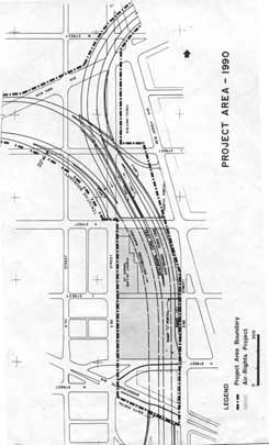
Center Leg extension showing transition radii to North Leg East
Center Leg extension: Built 1978-1982


No comments:
Post a Comment